Download presentation
Presentation is loading. Please wait.

1
Compiled / Created by: Bernardin-Lochmueller & Associates, Evansville, IN Quantm, Henderson, NV KARST FEATURES: Why Software is the CINDERELLA in I-69’s BIG DANCE

2
► First and foremost there needs to be clarification for a title like this, so… Why is software a Cinderella? GIS software is used for pre & post field work Quantm software is a decision making tool GPS software speeds up field work Cuts down on cost – no more hunting for the ‘Needle in the Haystack’ In the I-69 Mega-Project, software has made a Stunning impact on Karst analysis.

4
HOW DOES SOFTWARE HELP? GLOBAL POSITIONING SYSTEM – GPS GEOGRAPHIC INFORMATION SYSTEM – GIS ROUTE ANALYSIS SOFTWARE - QUANTM

5
Trimble GeoExplorer

6
► GPS SOFTWARE Allows for field crews to accurately pinpoint the location of cave locations Locations of caves can be loaded into the GPS unit prior to conducting field work, this allows for field personnel to go directly (in many cases) to cave opening instead of wandering around ‘hunting’ for the cave and thus saving valuable time & money.
 to cave opening instead of wandering around ‘hunting’ for the cave and thus saving valuable time & money.")
7
ArcView

8
GIS SOFTWARE Aids in identifying critical issues before conducting field work Create maps to aid in field work Create differing scenarios

9
QUANTM SOFTWARE

10
► Quantm Software With necessary data inputs Quantm can help by. ► Cutting Construction cost ► Manage Complex Environmental Issues ► Critical decision making process’s ► Improved environmental outcomes

11
A BRIEF HISTORY OF I - 69 INDOT wanted a GIS for the southwestern 26 counties of Indiana. Tier I began January 5 th 2000. Tier I ended March 24 th 2004. Indiana GIS completed in 2002. Tier II began March 2004.

12
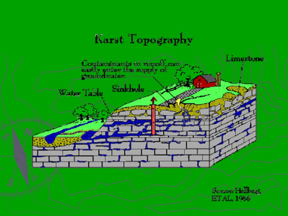
WHAT IS KARST? Karst occurs in carbonic rock such as limestone & dolomite. Karst forms by the rock dissolving groundwater in subterrainean settings

13
KARST EXTENT IN THE U.S.

15
WATER FLOW IN KARST CROSS-SECTION

16
KARST & CAVES

17
GROUNDWATER CONTAMINATION

18
SINKHOLE PLAIN

19
SURFICIAL CAVE-IN

20
CAVE-IN REPAIR

21
Where is Karst in Southern Indiana?

22
Where is I-69 in Southern Indiana?

23
INDIANA KARST FEATURES

24
GIS, GPS, AND QUANTM SOFTWARE HELPS US MAP IT! LOCATE IT! EVALUATE IT!

25
CONSIDERATIONS IN KARST CAVE ENVIRONMENTS SPECIES GROUND WATER & SPRINGS ENGINEERING

26
Threatened & Endangered SPECIES Indiana Bat

27
Threatened & Endangered SPECIES Blind CrayFish

28
Threatened & Endangered SPECIES Spotted Cave Salamander

29
Threatened & Endangered SPECIES Cave Cricket

30
KARST WELL

31
DYE TRACING

32
SPRINGS

33
SUBSURFACE EXPLORATION

34
HYDROLOGIC MODELING

35
MATERIAL TESTING

36
SOFTWARE IS ESSIENTIAL IN PROBLEM SOLVING IN THE I-69 PROJECT

Similar presentations