Download presentation
Presentation is loading. Please wait.

1
AFRICA - DIVERSE CONTINENT

2
While watching the clip, list 4 landforms you see in the video.

3
OBJECTIVES: understand key physical features and human activity that affect river systems by identifying how the Nile changes from source to mouth. examine how hydroelectric dams impact river systems around the world. SS-HS-4.2.2Students will explain how physical (e.g., climate, mountains, rivers) and human characteristics (e.g., interstate highways, urban centers, workforce) of regions create advantages and disadvantages for human activities in a specific place
 and human characteristics (e.g., interstate highways, urban centers, workforce) of regions create advantages and disadvantages for human activities in a specific place.")
4
PREVIEW What interesting details do you see?
What do you think this physical feature is? Complete the Preview

5
It is not surprising that you have so many questions about the Nile River.
At 4,160 miles in length, it is generally considered to be the longest river in the world. In the upcoming activity, you will follow the path of the Nile as it flows from its sources in the mountains and highlands of Africa to its mouth on the Mediterranean Sea. You will also learn about how the river changes along the way.

6
Read Section 1, Introduction, in the Student Text.
Identify at least four details in the mosaic that relate to ideas in the text you just read. Be prepared to share your answers with the class.

7
Examine the Graphic Organizer.
What interesting details do you see? What are the sources of the NILE? At about what parallel is each source located? Where is the river’s mouth? Through how many countries does the Nile flow?

8
What physical changes do you expect to happen to the Nile as it flows from its sources to its mouth?
What other types of changes might you expect to see as the Nile flows from its sources to its mouth?

9
How do rivers change as they flow across Earth’s surface?
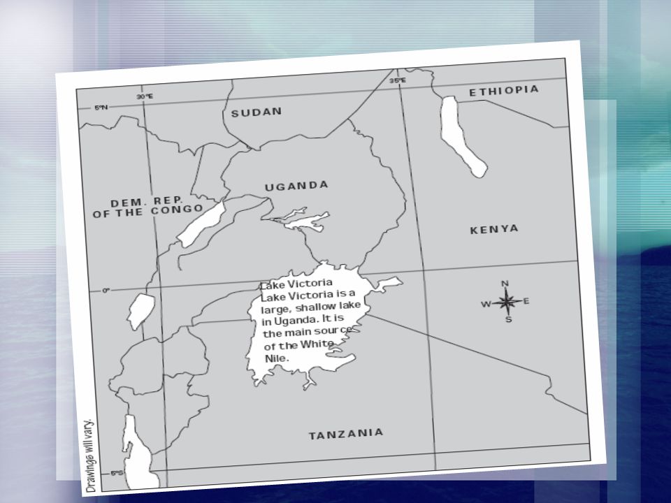
This map shows the course of the Nile River from its sources to the sea. The Nile flows through several countries and crosses several parallels of latitude, including the equator and the Tropic of Cancer. During its long journey, the Nile changes in many ways. Keep this map in mind as you try to answer the Essential Question.

11
Mark and label the feature on your map.
Step 2: Use the latitude and longitude coordinates on the placard to locate the feature on your map in Reading Notes for Section 19.

12
Step 3: Read the 19.3 of your text to find out more about the feature.
Step 4: In an appropriate place on your map, draw the feature. Write a caption that describes what the feature is. Your caption should also explain how the Nile River changes at that location.

15
Mark and label the feature on your map.
Step 2: Use the latitude and longitude coordinates on the placard to locate the feature on your map in Reading Notes for Section 19.

16
Step 3: Read the 19.3 of your text to find out more about the feature.
Step 4: In an appropriate place on your map, draw the feature. Write a caption that describes what the feature is. Your caption should also explain how the Nile River changes at that location.

18
Mark and label the feature on your map.
Step 2: Use the latitude and longitude coordinates on the placard to locate the feature on your map in Reading Notes for Section 19.

20
Step 3: Read the 19.4 of your text to find out more about the feature.
Step 4: In an appropriate place on your map, draw the feature. Write a caption that describes what the feature is. Your caption should also explain how the Nile River changes at that location.

22
Mark and label the feature on your map.
Step 2: Use the latitude and longitude coordinates on the placard to locate the feature on your map in Reading Notes for Section 19.

23
Step 3: Read the 19.5of your text to find out more about the feature.
Step 4: In an appropriate place on your map, draw the feature. Write a caption that describes what the feature is. Your caption should also explain how the Nile River changes at that location.

25
Mark and label the feature on your map.
Step 2: Use the latitude and longitude coordinates on the placard to locate the feature on your map in Reading Notes for Section 19.

26
Step 3: Read the 19.6 of your text to find out more about the feature.
Step 4: In an appropriate place on your map, draw the feature. Write a caption that describes what the feature is. Your caption should also explain how the Nile River changes at that location.

27
Longest River in the world – Nile
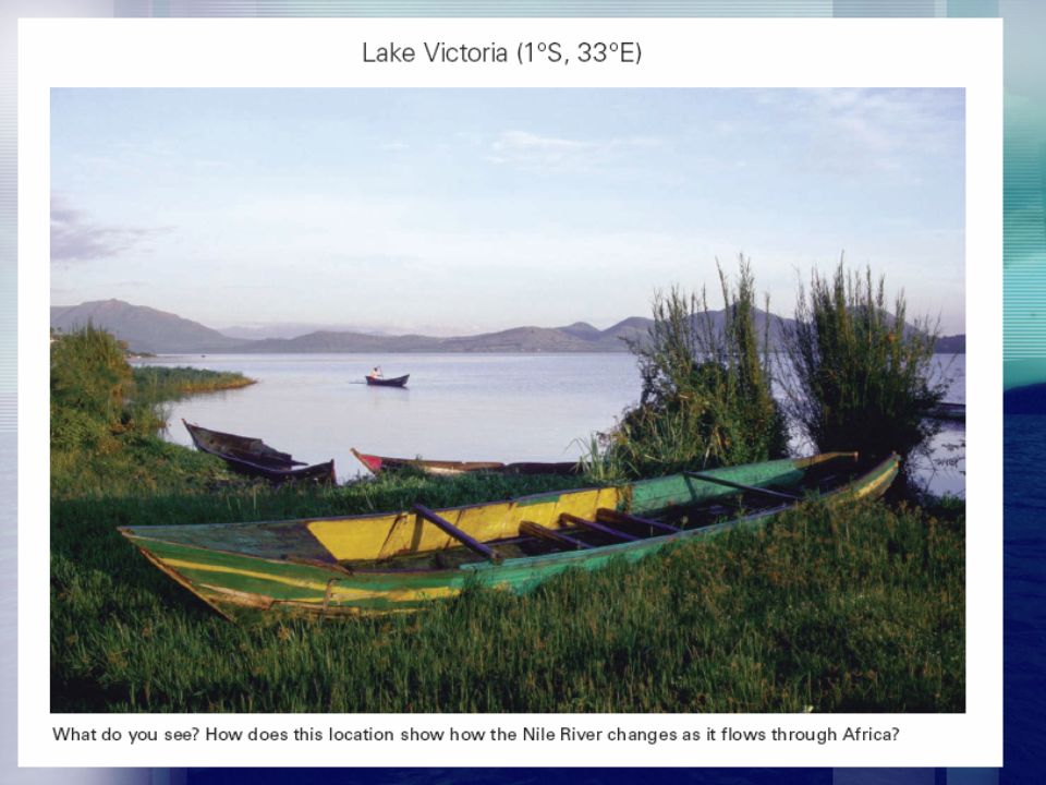
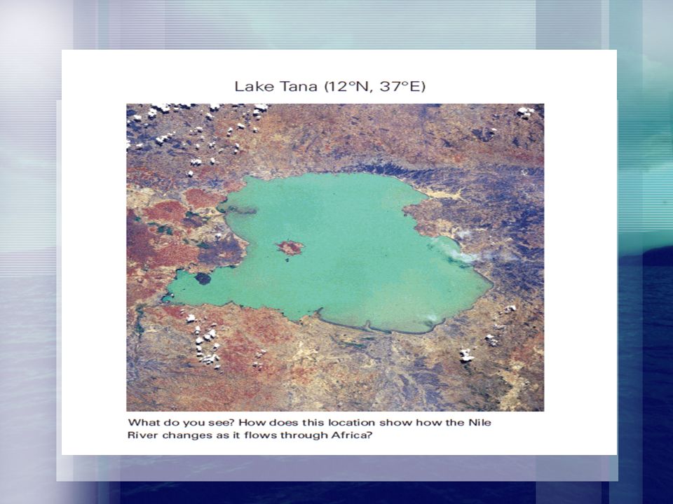
Two main branches of the Nile – Blue and White which meet in Khartoum, Sudan Blue Nile – source is Lake Tana White Nile -(begins in Lake Victoria) Flows through deserts and arid landscape
 Flows through deserts and arid landscape.")
28
Gift of Water, Transportation and Power
Drinking, cooking, washing, farming, transportation, and energy Aswan High Dam – 2 reasons why it was built Hydroelectric power control flooding

29
PREVIEW Complete Part 1 of the Preview for this lesson in your Interactive Student Notebook.

30
EXAMINE THE IMAGE

31
The physical environment is one influence on how people live.
People living on an island in the ocean may lead very different lives from people living on a continent near a river, because their physical environments are so different. Do you think that you would have the same daily routines and activities that you have now if you lived in the vast, dry lands of the Sahara?

32
In this lesson, you will learn about the physical characteristics of the Sahara and the Sahel and how people have adapted to the varied environments in this desert region. OBJECTIVES: Describe the physical characteristics of 3 environments of the Saharan Region Identify ways in which people have adapted to life in these environments Analyze the impact of desertification on people living in desert regions around the world

33
Sahara – Largest Desert in the world
3.5 million sq miles (United States) 15 African Countries Harshest, driest area in the world Less than 5 inches rain yearly What makes some of the Sahara liveable? Oases- an isolated area of vegetation in a desert
 15 African Countries. Harshest, driest area in the world. Less than 5 inches rain yearly. What makes some of the Sahara liveable Oases- an isolated area of vegetation in a desert.")
34
Sahel Lies on the southern border of the Sahara – drought and a little rain Not suitable for farming (MARGINAL LAND)
")
35
20.3 The Desert Environment
What are the physical characteristics of the desert? The Sahara has three main landforms: ergs – (sand dunes) regs-gravel covered plains and hammadas – high rock covered flatlands Only two rivers flow through the Sahara, the Nile and the Niger. Desert temperatures vary greatly between day (above 100) and night (below freezing) . Rain is unpredictable. How do you think people have adapted to living in the desert?
 regs-gravel covered plains and hammadas – high rock covered flatlands. Only two rivers flow through the Sahara, the Nile and the Niger. Desert temperatures vary greatly between day (above 100) and night (below freezing) . Rain is unpredictable. How do you think people have adapted to living in the desert")
36
20.4 Adaptations to Life in the Desert
How have people adapted to living in the desert? Among those who live in the Sahara are pastoral nomads such as the Tuareg. The Tuareg wear long, loose clothing to protect them from the sun. Tuareg traders use camels for transportation. Drilling machines have reached underground water to create new oases.

37
20.5 The Oasis Environment What are the physical characteristics of oases? Oases are tiny islands of fresh water in the desert. Some oases are natural. Others are made when humans dig or drill into the ground. Date palms are the most important and common oasis plant. How do you think people have adapted to living in oases?

38
20.6 Adaptations to Life in the Oases
How have people adapted to living in oases? Farmers grow cash crops like dates and vegetables. Visiting nomads trade their products for water and food. Farmers build windbreaks to protect their fields from the desert. People sometimes must walk to distant wells as an oasis town expands.

39
20.7 The Sahel Environment What are the physical characteristics of the Sahel? The land is marginal for farming. The vegetation is a mix of grasslands, acacia trees, baobab trees, and small bushes. Drought is a fact of life. Desertification has begun in some areas. How do you think people have adapted to living in the Sahel ?

40
20.8 Adaptations to Life in the Sahel
How have people adapted to living in the Sahel? Farmers plant crops, like millet and sorghum, that grow in dry places. Farmers use shifting agriculture. Herders move their herds from one grazing area to another throughout the year. Farmers are testing new ways of farming. People are starting to use coal instead of wood for cooking.

Similar presentations


 What might cause people to plant or graze their animals.>")


