Download presentation
Presentation is loading. Please wait.

1
Sarah E. Minson California Institute of Technology Benjamin A. Brooks, Jessica R. Murray U.S. Geological Survey Susan E. Owen Jet Propulsion Laboratory Robert A. Iannucci Carnegie Mellon University – Silicon Valley

2
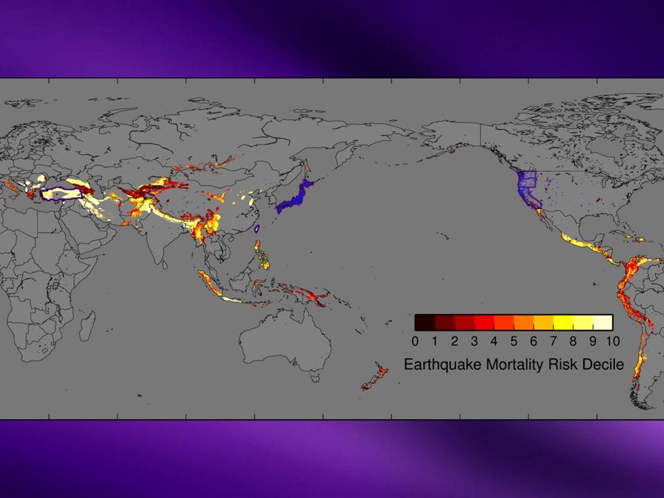
EEW and real-time GPS are expanding globally Most high-risk areas still not covered RT GPS EEWEEW

3
Requires dense networks of scientific instruments Expensive to build and maintain Scientific GPS: $1,000-$7,500 per year, per station Many high-risk areas cannot afford this investment RT GPS EEWEEW

4
Consumer electronics contain geophysical sensors Smartphones, laptops, tablets, cars What if we could monitor earthquakes with just consumer-quality sensors? RT GPS EEWEEW

5
This is not what you get from scientific instruments Pseudorange only (no phase information) Single frequency (coarse acquisition) vs. dual frequency Broadcast orbits

6
Post-processed scientific GPS PseudorangePseudorange

8
NorthNorthUpUpEastEast StaticStatic PseudorangePseudorange

9
Count number of stations for which they and their 4 closest neighbors have offsets greater than threshold

11
5 excursion from background

12
Displacement amplitude decays with distance Power law fit to observed offsets

13
S-wave reaches population center 5 exceeded

15
EEWEEW True Mw NEIC/PTWCNEIC/PTWC PseudorangePseudorange

18
If we wanted to replace GPS network with iPads: 500 stations @ $100 = $50,000 About the cost of installing 1-2 permanent GPS stations To replace GPS network with equal noise: 2,000 stations @ $100 = $200,000

19
We could build a workable early warning network for orders of magnitude less cost… …But really we don’t want to be responsible for the network

20
We should be using the GPS receivers people already own and maintain Significantly noisier (bad sky view, noisy environment) Potentially orders of magnitude more sensors Marginal cost to build and maintain Built-in way to track location and customize warnings Citizen science
 Potentially orders of magnitude more sensors Marginal cost to build and maintain Built-in way to track location and customize warnings Citizen science")
21
Scientific GPS: Mw 8.9 Best Slip Model: Mw 9.1 Pseudorange: Mw 8.9

22
Seismic EEW Scientific GPS NEIC/PTWCNEIC/PTWC PseudorangePseudorange True Mw What we are doing What we could do in western U.S. A way forward everywhere else

Similar presentations


 Prepared by Gary Cone.>")


, Norsang Gelsor 1) and Jens Havskov 2) 1) Jiangsu Road No 36 Lhasa, Tibet, PRC 2) University of Bergen, Department.>")

 August 2010 slow-slip.>")