Download presentation
Presentation is loading. Please wait.

1
Background for the Atlantic Trade Triangle A brief geography of winds and currents in the North Atlantic Ocean

2
Here is a globe, viewed from an angle that helps you focus on the Atlantic Ocean and the continents around it.

3
The orange square marks the location of the Cape Verde Islands, which were an important stop for sailing ships.

4
Near these islands, the wind blows from the northeast most of the time.

5
Near these islands, the wind blows from the northeast most of the time. This was good news if you wanted to go west in a sailing ship.

6
This was bad news if you thought that a flat world had an edge to the west!

7
What would you do about this?

8
One possibility is to observe the prevailing winds in different places.

9
For example, you might see what direction the winds blew at the latitude of Great Britain or northern France.

10
Observations there led to the conclusion that the winds tended to blow more often from the west or southwest.

11
When people put these observations together, they realized that a ship could “ride the trade winds” across the Atlantic Ocean..

12
.. and then turn northward and go along the coast (or the edge of the world!) until the westerly winds could push their ships back to Europe.
 until the westerly winds could push their ships back to Europe..")
13
That is why explorers often landed on islands in the Caribbean Sea rather than the coasts of North America or South America.

14
Now let’s look at how this worked during the era of colonial trade.

15
Ships from Europe would first go south along the coast of Africa.

16
Then they turned and headed west, pushed by the wind from the east.

17
The trade winds could take them quickly across the Atlantic Ocean.

18
Then they would go north along the coast of North America.

19
Finally, they used the westerly wind to push them back to Europe.

20
Summary From the British point of view, the North Atlantic winds were like an automatic gold-delivery system. Spanish ships went to the Americas, loaded up with treasure, and then had to sail close to England on their way back home.

21
And that is the geographic setting for the Spanish Armada and, later, the Triangle Trade.

23
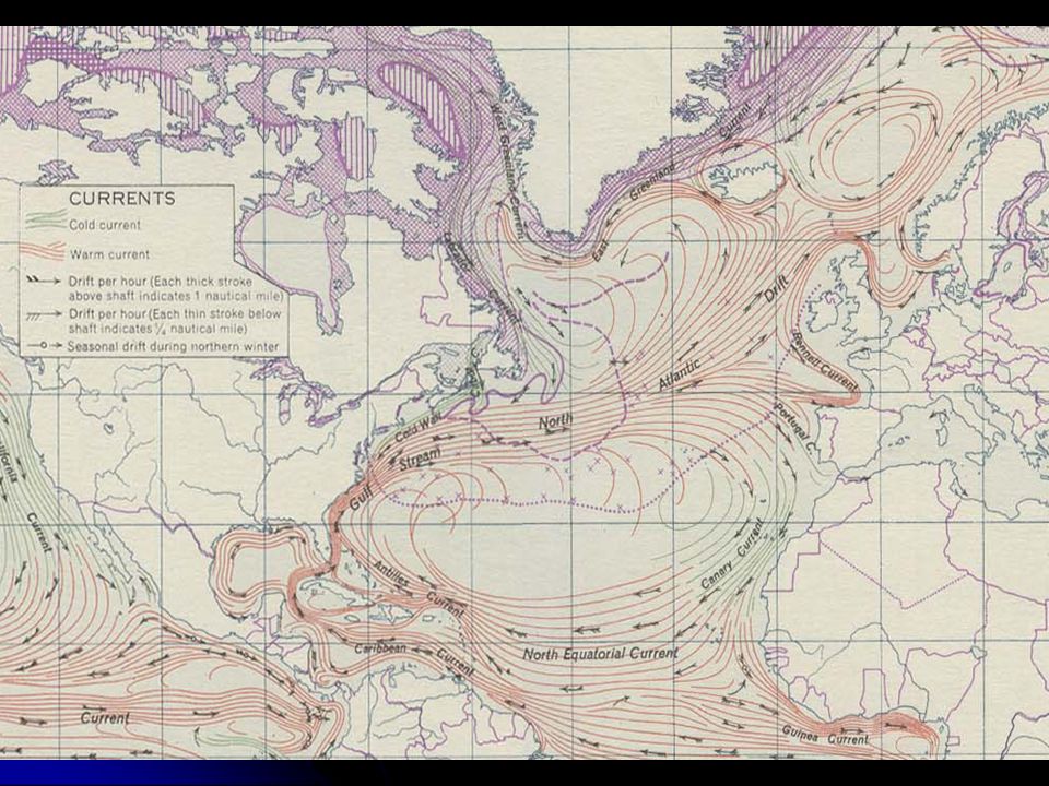
PS. Benjamin Franklin drew the first maps of this circulation.

24
Here is one of his maps He was especially interested in the Gulf Stream.

25
This is a modern map showing the temperature of the surface water in the Gulf Stream (red is warm, blue is cold). (National Oceanic and Atmospheric Administration

Similar presentations


>")

 were military expeditions sent>")


>")

