Download presentation
Presentation is loading. Please wait.

1
The Firewise Virginia Program John Miller - Chief, Resource Protection Virginia Department of Forestry

2
VDOF - 5 Year Average – 1529 Wildfires - 14,458 Acres

3
DOF Emergency Response Resources

4
DOF Incident Management Resources

5
The Firewise Virginia Effort firewise logo

6
Wildland Urban Interface Wildland Urban Interface

7
Virginia Statistics Virginia Homes/Structures Damaged or Destroyed YearNumber 2000178 2001121 200250 200322

8
Virginia’s Woodland Homes Estimate based on some preliminary assessment work in 2003

9
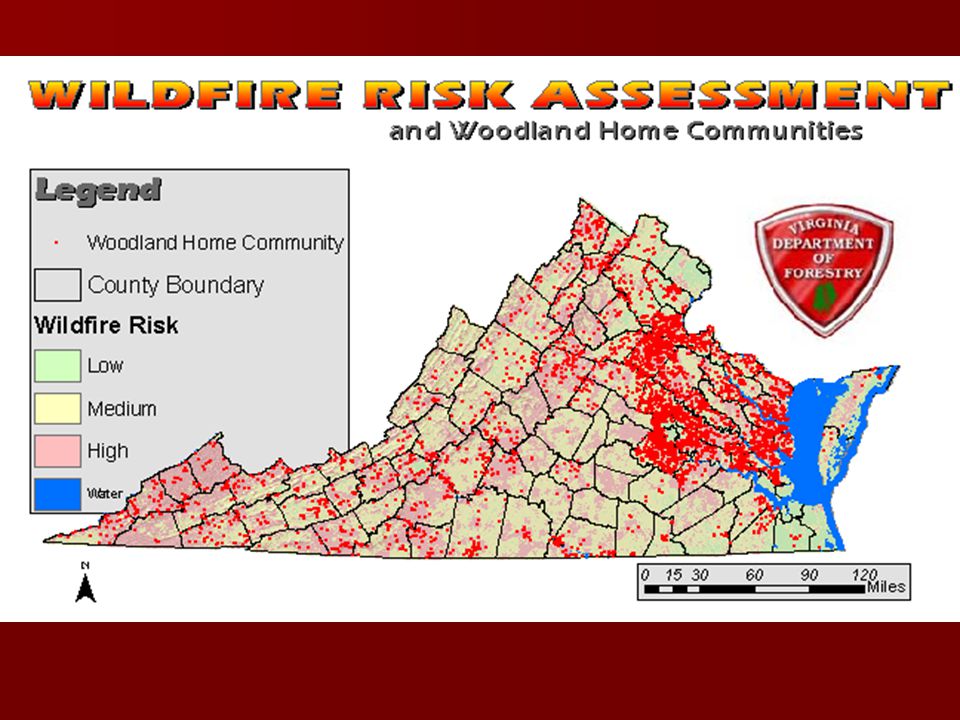
Firewise Virginia Statewide Risk Assessment Community Assessment Public Information Website Hazard Mitigation Projects

10
Statewide Wildfire Risk Assessment Goals - Identify and Quantify Wildfire Risks and Hazards Statewide. - Identify and Assess at-risk communities. - Reduce and/or Mitigate the hazards in identified at-risk communities. - Utilize risk assessment information for agency planning needs.

11
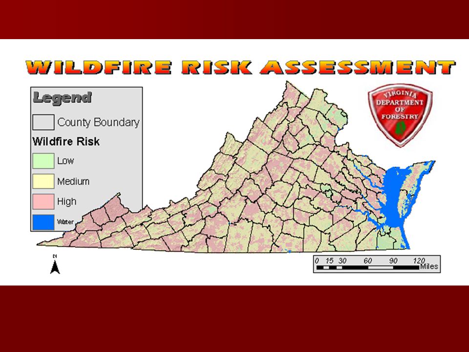
VDOF Wildfire Risk Assessment GIS Model VDOF Wildfire Risk Assessment GIS Model DOF developed a GIS model to objectively determine Wildfire Risk in Virginia DOF developed a GIS model to objectively determine Wildfire Risk in Virginia Used multiple input layers to model potential occurrence of wildfire Used multiple input layers to model potential occurrence of wildfire Layers were given different weight depending on their relative importance in determining risk Layers were given different weight depending on their relative importance in determining risk Layers were clipped by physiographic province so model could be run with three sets of parameter weights. Layers were clipped by physiographic province so model could be run with three sets of parameter weights.

12
VDOF Wildfire Risk Assessment GIS Model Inputs - Historical Wildfire Density - Landcover, Fuel Type, Resource Information - Topographic Features - Slope, Aspect, - Population Density - Distance to Roads - Cultural Improvements, Values at Risk

17
Wildfire Risk Assessment Uses - Woodland Home Communities, Firewise VA - Wildfire Hazard Mitigation - Dry Hydrant Program - Resource Allocation, Grants - Prevention Activities

18
Risk Assessment – New Focus

19
Virginia Forest Resource Information Mapper “ForestRIM” Project funding made possible through grants from

20
Objective To provide DOF field staff and the public-at-large with GIS tools and data for more informed decision-making. To provide DOF field staff and the public-at-large with GIS tools and data for more informed decision-making. ForestRIM is a warehouse for mapped information

21
ForestRIM Data Aerial photos - 1990’s DOQQs, 2002 VBMP Topo quads Landcover – NLCD, VDOF Forests, Soils, Wetlands Census - Block data for 1990, 2000 Hydrography - streams/rivers, waterbodies, watersheds, impaired waterways, public drinking water supply, scenic rivers Infrastructure - roads, airports, schools, hospitals Boundaries – counties, fed lands, political districts Topography - hillshade, slope, contours VDOF layers - Wildfire Risk, WHC, Dry hydrants, fire incidents, fuels, gypsy moth defoliation, etc. Over 100 Data Layers

22
ForestRIM Tools View information/GIS layers (zoom, pan, etc.) View information/GIS layers (zoom, pan, etc.) Query information/GIS layers: Query information/GIS layers: –By Attribute (i.e. Fires > 5 ac.) –By Geography (i.e. All Fires in Lee County) Produce professional-quality maps Produce professional-quality maps Annotate maps with text, points, lines, polys Annotate maps with text, points, lines, polys Calculate polygon acres Calculate polygon acres Get Lat/Long from cursor position Get Lat/Long from cursor position Upload and view GPS jobs over GIS layers Upload and view GPS jobs over GIS layers
 –By Geography (i.e. All Fires in Lee County) Produce professional-quality maps Produce professional-quality maps Annotate maps with text, points, lines, polys Annotate maps with text, points, lines, polys Calculate polygon acres Calculate polygon acres Get Lat/Long from cursor position Get Lat/Long from cursor position Upload and view GPS jobs over GIS layers Upload and view GPS jobs over GIS layers.")
23
WWW.DOF.FORESTRIM.ORG WWW.VDOF.ORG

24
ForestRIM Interface

25
Map Annotation Options Add Text, Points, Lines, Polygons Add Text, Points, Lines, Polygons Add GPS data Add GPS data Edit Symbology for annotations Edit Symbology for annotations Save Map View Save Map View

26
Secondary Search

27
What’s Next? Regional Workshops Continuing Push to Raise Awareness Focus on Hazard Mitigation Projects Continuous Program Improvements

28
Questions ?? MILLERJ@VDOF.ORG

Similar presentations


 G.P. Singh Technical Director National Informatics Centre, Govt. of India Kendriya Bhawan.>")


