Download presentation
Presentation is loading. Please wait.

1
West Virginia Department of Transportation Division of Highways Geospatial Transportation Information Section

2
Background GIS in wvOASIS LRS in wvOASIS Setting up GIS & LRS in wvOASIS Near Future Plan Qs & As

4
wvOASIS LRS

6
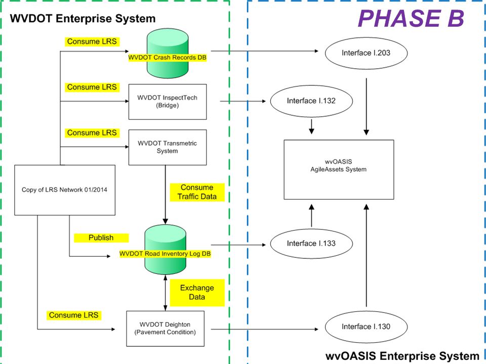
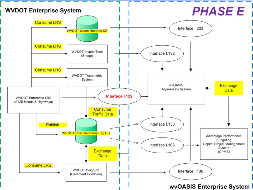
Our Advanced Solution w/ Integrated Systems Goals o Replace multiple outdated, stand-alone system w/ one integrated ERP System o Standardize business processes & practices across the state o Facilitate timely access to information for daily business Phases o Phase B: Safety, ROW, Transportation Asset Inventory, LRS, & GIS o Phase E: Transportation Asset Inventory, Transportation Operations Management, Capital Planning, Fleet, Facilities, Real Esate, & the Interface

7
4 th Quarter 2012 1 st Quarter 2013 2 nd Quarter 2013 3 rd Quarter 2013 4 th Quarter 2013 1 st Quarter 2014 2 nd Quarter 2014 3 rd Quarter 2014 4 th Qtr 2014 1 st Qtr 2015 2 nd Qtr 2015 Scope Budget Development Safety, Right of Way, Utility, Transportation Asset Inventory GL, Budget Control, AP, Revenue Accounting, Pcard, Grants, Cost Accounting, Project Accounting, Cash Management, Fixed Assets, Investments, Purchasing, Contracts, Inventory, Travel Expense, Financial Transparency, CAFR HR/Payroll, Time & Leave, Position Control, Class & Comp, Benefits, Learning, EE Relations, Billing, EES Transportation Ops & Assets, Safety, FHWA Billing, Fleet, Facilities & Real Estate, Travel, Federal Reciprocity Achieve Build Phase E Envision Build Achieve August 2013 January 2014 July 2014 January 2015 Phase A Envision Phase B Envision Phase D Envision Phase C Envision Build Achieve Build wvOASIS LRS Interface Design Kickoff A Snapshot of LRS Was Provided.

8
(AgileAssets AMS)
")
9
“ A linear reference system stores data using a relative position along existing line features. That is, location is given in terms of a known linear feature and a position, or measure, along it. For example, route I-10, mile 23.2, uniquely identifies a position in geographic space, and can be used instead of an x,y coordinate.” (http://resources.arcgis.com/en/help/main/10.1/index.html#//003m00000002000000)

10
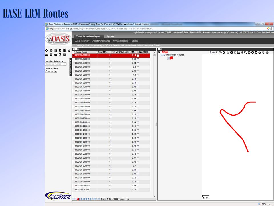
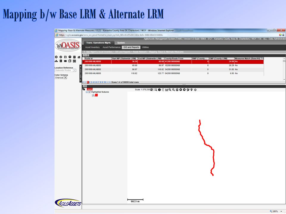
Two Linear Referencing Methods (LRMs) o Countywide LRM o Statewide LRM LRS Roadway Network o All Public Roads State Maintained Routes Non State Local Streets o Ramps o Crossovers o Railroads o Routes De-segmented at Intersections o Directionality
 o Countywide LRM o Statewide LRM LRS Roadway Network o All Public Roads State Maintained Routes Non State Local Streets o Ramps o Crossovers o Railroads o Routes De-segmented at Intersections o Directionality")
12
Client-Server GIS Solution o GIS Explorer o Oracle Spatial: SDO_GEOMETRY Other Features o Support Spatial Data in Multiple Formats o Support Integration w/ Esri ArcGIS o Possess Simple Mapping Functions

13
Easy-to-Follow GIS Layout Data from Multiple Sources in Multiple Formats Simple Symboligy Print or Export as PDF Map Save As Etc.

15
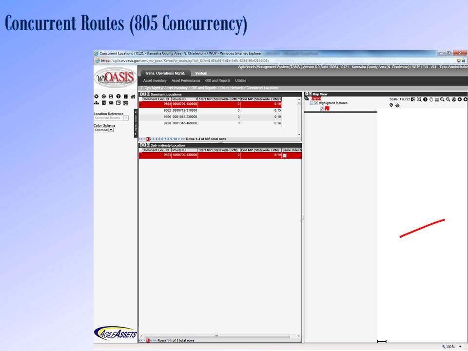
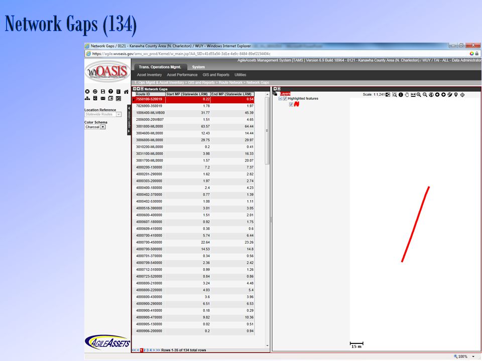
Two Linear Referencing Methods o Statewide LRM Base LRM o Countywide LRM Alternate LRM All Public Roads o State Maintained Routes o Non State Local Streets Railroads Special Road Network Features o Network Gaps o Concurrency

23
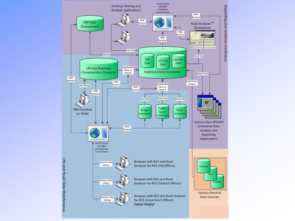
Make Sure GIS & LRS in wvOASIS Seamlessly Integrated into the WVDOT GIS & LRS Infrastructure

25
LRS Data Preparation for Phase B o LRS Model Improved o LRS Data Cleaned, Reformatted, Delivered, & Converted GIS Data Preparation for Phase B o Cultural/Economic/Social GIS Data Delivered o Web Services Published o Business GIS Data Delivered (e.g. Right-of-Way) Knowledge Transfer o Training in March 2014
 Knowledge Transfer o Training in March")
26
Maintaining GIS & LRS in wvOASIS/AgileAssets Implementing Esri Roads & Highways (R&H) Solution Integrating R&H & AgilesAssets AMS
 Solution Integrating R&H & AgilesAssets AMS")
27
Between AgileAsset AMS & Esri R&H Data Exchange for LRS Updates & Related Event Updates Functional Design Completed May 2013 In Production by December 2014

31
Deploy Esri R&H on time Deploy the Interface on time Improve LRS Data Fine Tune GIS Explorer Improve Web Services Customize Develop Applications Etc.

32
Yueming Wu, Ph.D., GISP GIS Manager WVDOT-Highways (304) 558-7437 yueming.wu@wv.gov
")
33
Others o Carrie Haight o Dustin Lowers o Everett Perry o Jessica Perkins o Lingyang Chen o Marla Johnson o Robert Maynard o Etc. IRG o Chuck Larson AgileAssets o Abhishek Bhargava o Eric Perrone o Phil Hardy o Siamak Saliminejad o Etc. Esri o Adrien Litton o Jackie Magnant o Silvia Casas o Will Isley o Etc. Transcend Spatial o Andrea Compton o Bill Schuman o Jesse Jay o Steven Korzekwa o Etc.

Similar presentations


 based “Decision Support System for Transport”>")


