Download presentation
Presentation is loading. Please wait.

1
NOAA Space Weather Prediction Center Products and Services T. Onsager, J. Kunches, W. Murtagh, and C. Balch NOAA GPS/GNSS Workshop Boulder, CO October 24, 2007

2
Outline Customer needs and actions Recent customer growth Products and services Vision for future products

3
Impact AreaCustomer (examples)Action (examples)Cost (examples) Radiation dose (dose limits & health risks, possible acute effects for space exploration missions) NASA exploration ISS Space tourism Airline crews/passengers Postpone activities Seek shelter Re-route flight paths Safety Issue Health risks Spacecraft (Individual systems to complete spacecraft failure; comm, drag, and radiation effects) Lockheed Martin Orbital Boeing Space Systems Loral NASA, DoD Postpone launch In orbit - Reboot systems Turn off/safe instruments and/or spacecraft Maintain orbit Loss of spacecraft ~$500M Commercial loss exceeds $1B Worst case storm - $100B Electric Power (Equipment damage to electrical grid failure and blackout conditions) U.S. Nuclear Regulatory Commission N. America Electric Reliability Corp. Allegheny Power New York Power Authority Adjust/reduce system load Disconnect components Postpone maintenance Estimated loss ~$400M from unexpected geomagnetic storms $3-6B loss in GDP (blackout) Airlines (Communications) (Loss of flight HF radio communications) United Airlines, Continental, Lufthansa, Korean Airlines NavCanada (Air Traffic Control) Divert polar flights Change flight plans Change altitude Select alternate comms Cost ~ $100k per diverted flight $10-50k for re-routes Surveying & Navigation (Use of magnetic field or GPS could be impacted) FAA-WAAS Dept. of Transportation BP Alaska and Schlumberger Fugro Chance – offshore oil rig Postpone activities Redo survey Use backup systems From $50k to $1 mil daily for single company Space Weather User Community
 Airlines (Communications) (Loss of flight HF radio communications) United Airlines, Continental, Lufthansa, Korean Airlines NavCanada (Air Traffic Control) Divert polar flights Change flight plans Change altitude Select alternate comms Cost ~ $100k per diverted flight $10-50k for re-routes Surveying & Navigation (Use of magnetic field or GPS could be impacted) FAA-WAAS Dept. of Transportation BP Alaska and Schlumberger Fugro Chance – offshore oil rig Postpone activities Redo survey Use backup systems From $50k to $1 mil daily for single company Space Weather User Community.")
4
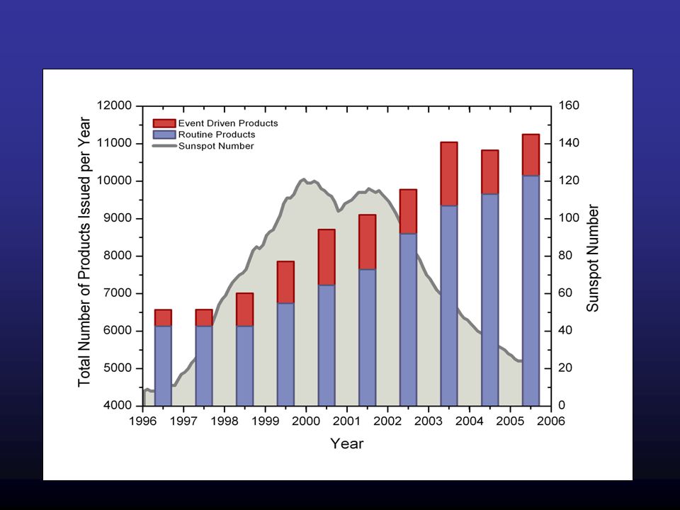
Recent Trends Steady overall growth of users Fastest growing user areas: GPS & Polar Aviation

5
Drivers for GPS market Deep-sea drilling Surveying FAA navigation systems DOD operations Mining & Farming operations Construction GPS Global Production Value – expected growth: –2003 - $13 billion –2008 - $21.5 billion –2017 - $757 billion Industrial Technology Research Institute (ITRI) – Mar 2005 Recent Trends
 – Mar 2005 Recent Trends")
7
If airborne survey data, or marine seismic data, are useless or poor, due to high solar activity levels…the financial and scheduling impact is significant, with costs in the $50,000 to $200,000 range daily for large airborne and marine platforms. Fugro Chance (April 2006) - “We use GPS worldwide to position oilrigs and survey vessels, perform marine construction survey operations as well as a variety of airborne GPS survey operations…It is crucial to our organization to receive information on impending solar activity”
 - We use GPS worldwide to position oilrigs and survey vessels, perform marine construction survey operations as well as a variety of airborne GPS survey operations…It is crucial to our organization to receive information on impending solar activity .")
8
SEC Customers – Drilling/Surveying

9
Major Forecast Center Products Daily Forecasts: -Solar flares -Solar energetic particles -Geomagnetic activity -10.7 cm radio flux Event-Driven Warnings and Alerts: -Warnings: geomagnetic storms, proton events -Alerts: solar flare, proton event, geomagnetic storm, electron event, solar radio burst

10
Operational Models U.S. Total Electron Content D-Region Absorption – HF Comm Outage STORM time empirical ionospheric correction model Geomagnetic Activity Index Prediction Solar Wind Prediction Relativistic Electron Forecast Model

11
U.S. Total Electron Content Model Real-time ionospheric maps of total electron content every 15 minutes Currently uses about 100 real-time GPS stations Model uncertainty is provided as the standard deviation in estimated TEC US-TEC slant path total electron content uncertainty < 2 TECU US-TEC vertical electron content uncertainty < 1 TECU Goal: Provide regional maps of TEC over the entire globe

12
NOAA POES NOAA GOES NASA ACE ESA/NASA SOHO L1 ACE (NASA) –Solar wind speed, density, temperature and energetic particles –Vector Magnetic field SOHO (ESA/NASA) –Solar EUV Images –Solar Corona (CMEs) GOES (NOAA) –Energetic Particles –Magnetic Field –Solar X-ray Flux –Solar EUV Flux –Solar X-Ray Images POES (NOAA) –High Energy Particles –Total Energy Deposition –Solar UV Flux Ground Sites –Magnetometers (NOAA/USGS) –Thule Riometer and Neutron monitor (USAF) –SOON Sites (USAF) –RSTN (USAF) –Telescopes and Magnetographs –Ionosondes (AF, ISES, …) –GPS (CORS) Key Data Sources STEREO (NASA) –Solar EUV Images –Solar Corona & Heliosphere (CMEs) –In-situ plasma & fields –In-situ energetic particles –SWAVES
 –Solar wind speed, density, temperature and energetic particles –Vector Magnetic field SOHO (ESA/NASA) –Solar EUV Images –Solar Corona (CMEs) GOES (NOAA) –Energetic Particles –Magnetic Field –Solar X-ray Flux –Solar EUV Flux –Solar X-Ray Images POES (NOAA) –High Energy Particles –Total Energy Deposition –Solar UV Flux Ground Sites –Magnetometers (NOAA/USGS) –Thule Riometer and Neutron monitor (USAF) –SOON Sites (USAF) –RSTN (USAF) –Telescopes and Magnetographs –Ionosondes (AF, ISES, …) –GPS (CORS) Key Data Sources STEREO (NASA) –Solar EUV Images –Solar Corona & Heliosphere (CMEs) –In-situ plasma & fields –In-situ energetic particles –SWAVES")
13
Future Products Forecasts, Forecasts, Forecasts!!! –IF GOES, STEREO, and SDO give better solar observations –AND ACE, STEREO, KwaFu give the solar wind propagating earthward –PLUS CORS, COSMIC give ionospheric conditions globally –THEN USTEC and newer renditions give predictions for Positioning /Navigation/Timing (PNT) users External user base continues to grow –Electronic navigation (GPS III, Galileo, Glonass, Compass, etc., plus backup system eLoran) –Commercial providers, per recent interaction with AGI –NextGen, E911/E112, ADS-B implementations all rely on GPS/GNSS to be the best it can be Internal to NOAA, user base also expanding –Airborne, marine, ground surveying all need optimal GPS/GNSS
 users External user base continues to grow –Electronic navigation (GPS III, Galileo, Glonass, Compass, etc., plus backup system eLoran) –Commercial providers, per recent interaction with AGI –NextGen, E911/E112, ADS-B implementations all rely on GPS/GNSS to be the best it can be Internal to NOAA, user base also expanding –Airborne, marine, ground surveying all need optimal GPS/GNSS.")
Similar presentations