Download presentation
Presentation is loading. Please wait.

1
Integrating Global Species Distributions, Remote Sensing and Climate Station Data to Assess Biodiversity Response to Climate Change Adam Wilson & Walter Jetz, Yale University on behalf of PIs W. Jetz, R. Guralnick, B. McGill, R. Nemani, F. Melton April 26, 2012

2
1970–1997 1940–1969 1915–1939 Scattered examples of range shifts… 20 th century changes in the range of butterfly Pararge aegeria Nature (1999) 399:579:583 … but no global analysis across taxa Great Britain http://www.nymphalidae.net/
 399:579:583 … but no global analysis across taxa Great Britain")
3
Question: How much change in the: 1.geographic and 2.multivariate niche space of (best-sampled) species? Assessing species distribution responses to recent environmental change

4
Project Overview

5
Aster GDEM2 ASTER/SRTM Blend using Gaussian function at overlap area: 55N-60N SRTM 2) Accuracy assessment: Compare to GMTED2010 (1km resolution) Global DEM GMTED2010 Global DEM GMTED2010 Oregon, USA: Datasets should match Northwestern Canada: Data in blend zone Global 90m DEM from SRTM & ASTER data
 Accuracy assessment: Compare to GMTED2010 (1km resolution) Global DEM GMTED2010 Global DEM GMTED2010 Oregon, USA: Datasets should match Northwestern Canada: Data in blend zone Global 90m DEM from SRTM & ASTER data")
6
WorldClim.org Temperature stations included in WorldClim 1km Monthly climatology >6,500 citations since 2006

7
Satellite-Station Data Fusion Two statistical approaches: 1.Interpolate raw values day-by-day using remotely sensed information (LST, clouds, topography, land cover, etc.) as covariates 2.Climate-aided interpolation – Monthly climatologies (2000-2011) from MODIS and station means – Interpolate daily station anomalies Goal: Develop daily 1km surfaces of tmax, tmin, and ppt with MODIS and climate station data (1970- 2011).
 as covariates 2.Climate-aided interpolation – Monthly climatologies ( ) from MODIS and station means – Interpolate daily station anomalies Goal: Develop daily 1km surfaces of tmax, tmin, and ppt with MODIS and climate station data ( ).")
8
Satellite Weather Products Precipitation: 1.TRMM (1/4 o ) 2.MODIS Cloud Product (MOD06_L2) Temperature: MODIS LST (MOD11A1)
 2.MODIS Cloud Product (MOD06_L2) Temperature: MODIS LST (MOD11A1)")
9
Interpolation Methods (raw & climate-aided) 1.Generalized Additive Models (GAMs) 2.Geographically weighted regression (GWR) 3.Thin-plate splines 4.Kriging/co-kriging (conventional and Bayesian)
 1.Generalized Additive Models (GAMs) 2.Geographically weighted regression (GWR) 3.Thin-plate splines 4.Kriging/co-kriging (conventional and Bayesian)")
10
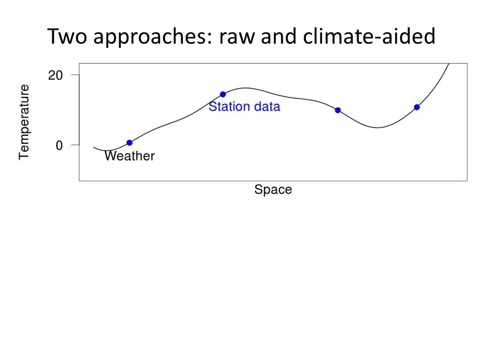
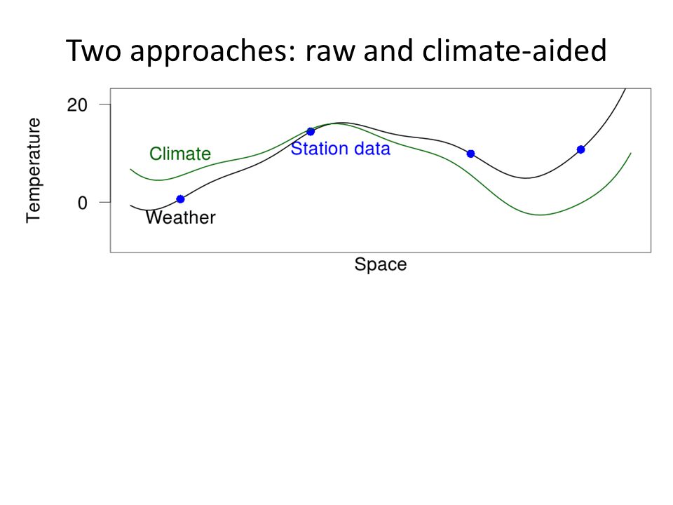
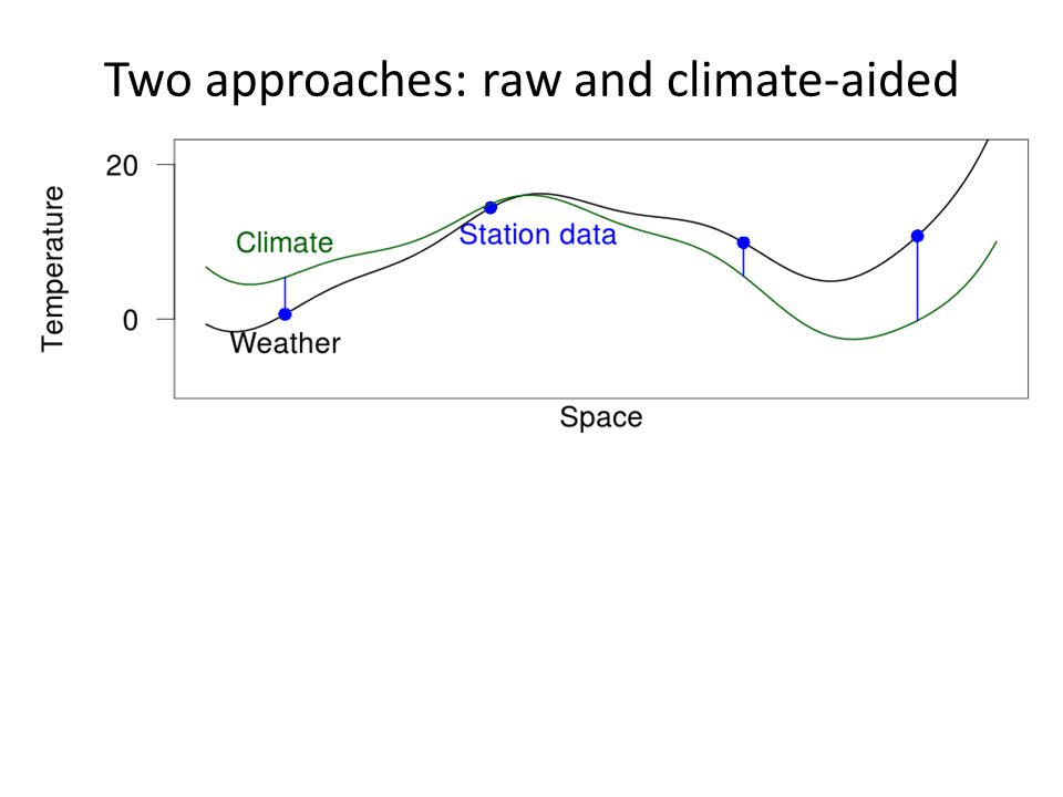
Two approaches: raw and climate-aided

15
Much smoother surface

16
spatial variability within the climatology accounts for most of the temporal between-station variability (Willmott & Robeson, 1995) anomalies are strongly correlated out to distances of the order of 1000 km (Hansen and Lebede, 1987) anomalies are relatively free of the considerable topography-forced spatial variability (Willmott & Robeson, 1995) Climate-aided Interpolation Di Luzio, et. al (2008); Hunter & Meentemeyer (2005); Perry, et. al (2005); Willmott & Robeson (1995)
; Hunter & Meentemeyer (2005); Perry, et. al (2005); Willmott & Robeson (1995).")
17
Case Study: Oregon Model Comparison (RMSE of validation data across models)
")
18
Case Study: South Africa 1980-2010 daily interpolations at ~1.5km resolution in South Africa Used existing climate surfaces, no satellite data

19
Case Study: South Africa Successful prediction of: 97% dry days (≤ 2mm) 66% wet days Predictive Accuracy for Validation Stations
 66% wet days Predictive Accuracy for Validation Stations")
20
Next Steps: Phase 1 Develop monthly climatologies using MODIS LST (MOD11A1) and cloud data (MOD06_L2) Finalize comparison of interpolation methods Expand analysis to other focal regions – Oregon, South Africa, Costa Rica, Norway Generate layers globally
 and cloud data (MOD06_L2) Finalize comparison of interpolation methods Expand analysis to other focal regions – Oregon, South Africa, Costa Rica, Norway Generate layers globally")
21
GBIF: 43,700,000 bird records … Available species point occurrences Geographically and environmentally biased Need extensive cleaning/processing before use

22
Map of Life Mobilizing multi-source biodiversity data: Point records Expert range maps Species lists Facilitates quality control on large datasets Jetz, McPherson, & Guralnick (2012) Integrating biodiversity distribution knowledge: toward a global map of life. Trends in Ecology & Evolution, 27(3), 151–159 TypeSourceAmphibiansBirdsMammalsReptilesFish PointsGBIF1.8m132.4m4.4m1.7m Expert MapsIUCN/others6k10k4k1k Local InventoriesVarious2k48k10k Regional ChecklistsWWF12k201k68k
, 151–159 TypeSourceAmphibiansBirdsMammalsReptilesFish PointsGBIF1.8m132.4m4.4m1.7m Expert MapsIUCN/others6k10k4k1k Local InventoriesVarious2k48k10k Regional ChecklistsWWF12k201k68k.")
23
Assessing Change: historical species observations ClassSpeciesAvg. records per species 1971‐1990 Avg. records per species 1991‐2010 Amphibia126831567 Aves1,2863,07528,044 Mammalia3608341,070 Reptilia119379605

24
Extended team and funding Mark Schildhauer, Jim Regetz, Benoit Parmentier, George Cooper mappinglife.org

Similar presentations


 MOHC (results to be used in WP3): max and min surface air temperature products.>")

 Project is funded by the Climate Change Action Fund and provides climate change scenarios and related information.>")


>")

>")


