Download presentation
Presentation is loading. Please wait.

1
The Physical Geography of Canada

2
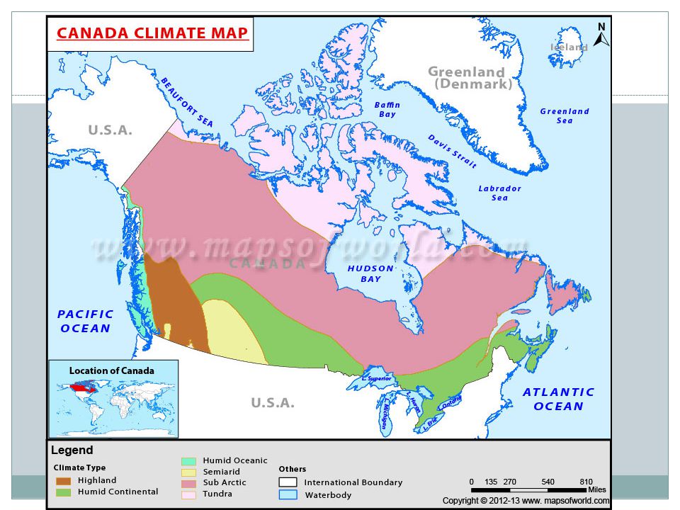
Overview Canada occupies most of the northern half of the American continent. It is located directly north of the United States It has fertile plains, rugged mountains, and large metropolitan cities.

4
Provinces and Territories
Province- a territory that is under the control of a larger country- Head of State the Queen of England A province is similar to a state in the United States. - Have governments, governors in each province -created/listed in their Constitution - Can make laws on education, the environment, and changes to their constitution. -10 provinces in Canada

5
Provinces and Territories
Territories have less power than provinces -Created by federal law and managed by Canadian national government. -Have representation in government -cannot make changes to their constitution - 3 territories in Canada

6
Memorizing Canadian Provinces
Acronym: Bart A. Simpson Marred Our Quiet Night Come up with your own!!

7
Canadian Facts, Eh? Canada is the second largest country in the world (space wise, not population) It is slightly smaller than all of Europe which is made up of 45 countries. It only borders one country, the United States. 90% of Canada is too cold for agriculture to take place.

9
Where do People Live? Why?

10
Landforms and Soils The physical make-up of Canada is the result of changes to the Earth: For example, the bringing together of several smaller continents more than 2. 5 billion years ago accounts for the different types of rocks found in the Canadian Shield. For example, the mountain systems are geological developments (The Rockies). The landscape of Canada was also affected by glaciation and was under a thick sheet of ice called a glacier. Melting glaciers formed the Great Lakes and lakes in CS. Almost all of Canada was under ice a sometime during the last 1.5 million years. Now only 1% is under ice.
. The landscape of Canada was also affected by glaciation and was under a thick sheet of ice called a glacier. Melting glaciers formed the Great Lakes and lakes in CS. Almost all of Canada was under ice a sometime during the last 1.5 million years. Now only 1% is under ice.")
11
Regions of Canada 1. Western Cordillera 2. Interior Plains
3. Canadian Shield 4. Arctic North St. Lawrence Lowlands

12
1. Western Cordillera The Western Cordillera runs along the west coast of North America. This region is made up of rugged mountains. The Rocky Mountains are included in Western Cordillera/ Major provinces include British Columbia and Yukon Territory.

13
Western Cordillera The region is a major source of lead, zinc, copper, and gold. Therefore, the economies in the Western Cordillera are based on logging, mining, and tourism.

14
2. Interior Plains Grassy plains that are mostly flat.
Consist of Alberta, Saskatchewan, and Manitoba. There are a lot of farms. Primary industry is agriculture

15
3. Canadian Shield Largest region that includes most of Quebec, Ontario, northern Manitoba, northern Saskatchewan, Nunavut and half of the North West Territory. Covers more than half of Canada A rocky landscape with lots of rivers and lakes.

16
Canadian Shield Has very rich mining opportunities including copper, iron, nickel, silver and gold. Very few people live there- mining towns.

17
Contains a chain of islands in Canada’s far north called the Artic Archipelago.
It is a polar region located at the northernmost part of the Earth. Permafrost is soil that remains frozen for more than 2 years. It includes a major part of the North West Territory and small parts of the Yukon, Manitoba, Ontario, and Quebec. 4) Arctic North
 Arctic North.")
18
Arctic Population and Cities
Over 20 Aboriginal bands live in the region, as well as over 30, 000 Inuit. Earliest Europeans came around 1500s during the age of exploration looking for Northwest passage.

19
The Arctic Economy Gold discoveries in the Yukon in the 1890s and mining finds in the 1930s brought more significant settlements. oil and gas exploration Trapping and fishing. Metallic minerals have also been found, including zinc, iron ore, lead, and, most recently, diamonds

20
5. St.Lawrence Lowlands Also referred to as the Heartland of Canada
Very small region that includes southern tips of Ontario and Quebec. However, includes 50% of Canada’s population. Extremely fertile soils result great agriculture. A lot of industry located here Easy transportation routes

21
St. Lawrence Lowlands

22
6) Atlantic Region Covers 2 percent of Canada’s area.
Includes Nova Scotia, New Brunswick, and Prince Edward Island Fishing is a major industry offshore oil and gas development in current years.

Similar presentations