Download presentation
Presentation is loading. Please wait.

1
HERAKLION (partner NOA) Institute of Geodynamics National Observatory of Athens, Greece (1892-today) HERAKLION (partner NOA) Institute of Geodynamics National Observatory of Athens, Greece (1892-today)
 Institute of Geodynamics National Observatory of Athens, Greece (1892-today) HERAKLION (partner NOA) Institute of Geodynamics National Observatory of Athens, Greece (1892-today)")
2
Institute of Geodynamics, NOA 1892-today -national seismograph system 24/7 -national tsunami warning center -geodynamics/active tectonics -engineering seismology -applied geophysics - early warning systems/forecasting

4
Daskalaki et al., EGU, 2013

5
Tsunami history of Crete Many earthquakes Pre-historical documented from geology & archaeology Historical documented through a long nmuber of documents Instrumental after 1910 Several tsunamis hit Crete/Heraklion

6
Large tsunamigenic earthquakes Rupture zones of the most important tsunamigenic earthquakes in Greece and surrounding regions (Papadopoulos & Papageorgiou, Cambridge Univ. Press, 2014)
.")
7
Region:Crete Island, Greece Test site: Heraklion Coastal Zone, Crete, Greece Area: 200km2 – important selected localities are included Responsible : NOA Impacts by: Earthquakes in the South Aegean region Volcanic eruptions in the Aegean region - Santorini Landslides in the South Aegean region and possibly other areas in the East Mediterranean Main endangered assets: Main Shipping Port and ferry dock (See site description text below) International Airport (the second largest in Greece - major tourist and holiday destination) Coastal city of Heraklion (173,993 inhabitants) Hotel Complexes, Marinas, Tourist attractions, Ancient Knossos Palace, Crowded Beaches Main Power Plant for Crete, Oil, Petrol and Gas Storage Tank facilities
 International Airport (the second largest in Greece - major tourist and holiday destination) Coastal city of Heraklion (173,993 inhabitants) Hotel Complexes, Marinas, Tourist attractions, Ancient Knossos Palace, Crowded Beaches Main Power Plant for Crete, Oil, Petrol and Gas Storage Tank facilities")
8
EXISTING DATA AND RESOURCES FOR HAZARD, VULNERABILITY AND RISK ASSESSMENT Baseline data Digital Elevation Model (DEM) Available at NOA from cartographic data (1:5000 scale), 30-m ASTER, 90-m SRTM Bathymetric data Available at the Hellenic Navy Hydrographic Service at 1:5000 scale Land use/Land cover Available from CORINE database (year 2000, scale 1:100.000) and scientific studies from Universities Socio-Economic Vulnerability Data Coastal communities Available at NOA from EL.STAT, population, boundaries etc Tourism Available from the Greek Chamber for Tourism
 Available at NOA from cartographic data (1:5000 scale), 30-m ASTER, 90-m SRTM Bathymetric data Available at the Hellenic Navy Hydrographic Service at 1:5000 scale Land use/Land cover Available from CORINE database (year 2000, scale 1: ) and scientific studies from Universities Socio-Economic Vulnerability Data Coastal communities Available at NOA from EL.STAT, population, boundaries etc Tourism Available from the Greek Chamber for Tourism")
9
Environmental Vulnerability Data Seafloor and coastal erosion and sedimentation Base line administration reports (Region of Crete) and maps and scientific studies from HCMR and Universities Ecosystem abrasion, suffocation and other damages Base line administration reports (Region of Crete) and maps and scientific studies from HCMR and Universities Flooding by salt water Base line administration reports (water management – City of Heraklion) and maps and scientific studies
 and maps and scientific studies from HCMR and Universities Ecosystem abrasion, suffocation and other damages Base line administration reports (Region of Crete) and maps and scientific studies from HCMR and Universities Flooding by salt water Base line administration reports (water management – City of Heraklion) and maps and scientific studies")
10
Structural Vulnerability Data Buildings Available at NOA Heraklion City Plan 1:5000 Road network Available at NOA Heraklion City Plan 1:5000 Pipelines Available at NOA Heraklion City Plan 1:5000 Crisis Management Resources Civil Protection system (including firemen, evacuation,..) Decentralized Administration of Crete (POSEIDON 2011 tsunami exercise) Hospitals Decentralized Administration of Crete, Region of Crete and Municipality of Heraklion Authorities Security Decentralized Administration of Crete, Region of Crete and Municipality of Heraklion Authorities
 Decentralized Administration of Crete (POSEIDON 2011 tsunami exercise) Hospitals Decentralized Administration of Crete, Region of Crete and Municipality of Heraklion Authorities Security Decentralized Administration of Crete, Region of Crete and Municipality of Heraklion Authorities")
11
ASTARTE INNOVATIVE CONTRIBUTIONS Recurrence, sources (WP2) and tsunami generation mechanisms (WP3) Submarine Earthquakes Review on Earthquakes in the South Aegean Landslides Review on Landslide sources in the South Aegean Submarine volcanism Santorini volcano and the Hellenic Volcanic Arc Zone Impacts on coastal structures (WP5) Buildings Knossos Ancient Palace Road network Main Coastal Motorway Lifelines Main Power Plant Harbors Heraklion Port Other Heraklion International Airport Numerical modeling (WP4) Hazard Tsunami impact and harbor resonance Vulnerability Structural, socio-economic and environmental RiskCoastal flooding
 and tsunami generation mechanisms (WP3) Submarine Earthquakes Review on Earthquakes in the South Aegean Landslides Review on Landslide sources in the South Aegean Submarine volcanism Santorini volcano and the Hellenic Volcanic Arc Zone Impacts on coastal structures (WP5) Buildings Knossos Ancient Palace Road network Main Coastal Motorway Lifelines Main Power Plant Harbors Heraklion Port Other Heraklion International Airport Numerical modeling (WP4) Hazard Tsunami impact and harbor resonance Vulnerability Structural, socio-economic and environmental RiskCoastal flooding")
12
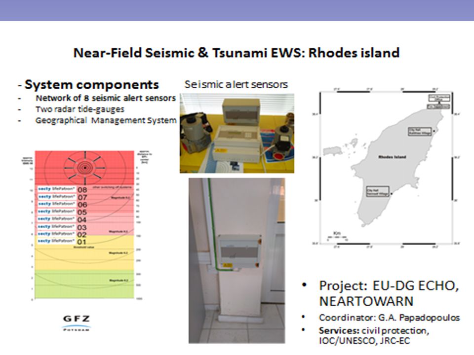
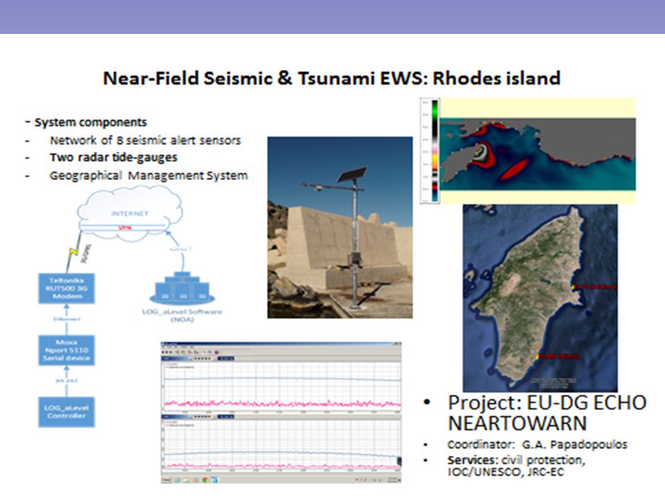
Operational detection and communicat ion (WP6) The site has been hit by tsunamis since ancient times (e.g. Minoan tsunami). Tide gauge data in the Aegean sea and their integration into TWS. Review of communication infrastructure, methodologies and protocols Early warning and forecast (WP7) Assessment of alert methodology and criteria and proposals for improvement. Interaction with Civil Protection on the expected information and products to be obtained from a TWS. Test and validation of new products for tsunami forecast implemented in extra-European regions. Interoperability, and data and information exchange policy.
. Tide gauge data in the Aegean sea and their integration into TWS. Review of communication infrastructure, methodologies and protocols Early warning and forecast (WP7) Assessment of alert methodology and criteria and proposals for improvement. Interaction with Civil Protection on the expected information and products to be obtained from a TWS. Test and validation of new products for tsunami forecast implemented in extra-European regions. Interoperability, and data and information exchange policy..")
13
From hazard to risk assessment (WP8) Probabilistic Tsunami Hazard Assessment (PTHA) and Scenario- Based Tsunami Hazard Assessment (SBTHA). Addressing tsunami analyses in terms of vulnerability and risk, integrated coastal management, and examining tools and strategies of prevention and mitigation in the long term as well as emergency plans. Building tsunami resilient societies (WP9) Interaction with Civil Protection on the expected information and products to be obtained. Experiences from the late POSEIDON 2011 Tsunami Exercise in Crete
 Interaction with Civil Protection on the expected information and products to be obtained. Experiences from the late POSEIDON 2011 Tsunami Exercise in Crete.")
14
END USERS NameExpression of interest Municipality of HeraklionYes (letter of support) Decentralised Administration of Crete Yes (letter of support) ASTARTE TEST SITES Test Site: Heraklion City Coastal Zone: Strategic Coastal Zone for Tourism in Crete, Greece, with important lifelines such as Main Port, International Airport, Power Plant, Industrial Zone, Shopping Malls and Sports Complex all situated within this coastal zone (North Crete Island)
 Decentralised Administration of Crete Yes (letter of support) ASTARTE TEST SITES Test Site: Heraklion City Coastal Zone: Strategic Coastal Zone for Tourism in Crete, Greece, with important lifelines such as Main Port, International Airport, Power Plant, Industrial Zone, Shopping Malls and Sports Complex all situated within this coastal zone (North Crete Island)")
15
Photographs of the Heraklion Coastal Zone Old and New Port next to each other (left) and International Airport (right), situated both one next to the other to the East end of the Heraklion City A tsunami risk management pilot study in Heraklion, Crete. Natural Hazards, 18, 91-118, 1998 (G. A. Papadopoulos & Th. Dermentzopoulos). Assessing tsunami vulnerability, an example from Herakleio, Crete. Natural Hazards and Earth System Sciences, 3, 377–389, 2003 (M. Papathoma et al.).
. Assessing tsunami vulnerability, an example from Herakleio, Crete. Natural Hazards and Earth System Sciences, 3, 377–389, 2003 (M. Papathoma et al.)..")
Similar presentations


![Climate Change Impacts in the United States Third National Climate Assessment [Name] [Date] Coasts.](/13/3925513/big_thumb.jpg "Climate Change Impacts in the United States Third National Climate Assessment [Name] [Date] Coasts.>")

 NTHMP.>")


 ASTARTE WP8 Meeting Bologna, 7 March 2014.>")
 Pacific Disaster Center.>")


 (2002 – 2003) Pacific Risk Management `Ohana (PRiMO) (2004.>")

