Download presentation
Presentation is loading. Please wait.

1
King Abdulaziz University, Kingdom of Saudi Arabia

2
Biography Since Aug. 2012 and on, Dr. Elhag is practicing his field of expertise as assistant professor in King Abdulaziz University, Department of Hydrology and Water Resources Management on both of academic and research levels. Dr. Mohamed Elhag had obtained his PhD degree from the School of Agricultural Sciences, University of Thessaly, Greece in Water Resources Management. He is the author of several articles published in reputed journals and is a member of different international working groups related to his background. A substantial portion of his work at the graduate level has involved groundwork and teaching the applications of Remote Sensing in Natural Resources Management as a part of multi prospective of Earth Science. Earlier, his PhD thesis in which he conducted a full literature search, investigate and analyse original documents, synthesized hisresearch, and wrote on water resources management using integrated Remote Sensing applications and Geographical Information System techniques.

3
OMICS Group welcomes submissions that are original and technically so as to serve both the developing world and developed countries in the best possible way. OMICS Journals are poised in excellence by publishing high quality research. OMICS Group follows an Editorial Manager® System peer review process and boasts of a strong and active editorial board. Editors and reviewers are experts in their field and provide anonymous, unbiased and detailed reviews of all submissions. The journal gives the options of multiple language translations for all the articles and all archived articles are available in HTML, XML, PDF and audio formats. Also, all the published articles are archived in repositories and indexing services like DOAJ, CAS, Google Scholar, Scientific Commons, Index Copernicus, EBSCO, HINARI and GALE. For more details please visit our website: http://omicsonline.org/Submitmanuscript.php http://omicsonline.org/Submitmanuscript.php OMICS Journals are welcoming Submissions

4
OMICS Group Contact us at: contact.omics@omicsonline.org OMICS Group International through its Open Access Initiative is committed to make genuine and reliable contributions to the scientific community. OMICS Group hosts over 400 leading-edge peer reviewed Open Access Journals and organizes over 300 International Conferences annually all over the world. OMICS Publishing Group journals have over 3 million readers and the fame and success of the same can be attributed to the strong editorial board which contains over 30000 eminent personalities that ensure a rapid, quality and quick review process. OMICS Group signed an agreement with more than 1000 International Societies to make healthcare information Open Access.

5
Remote Sensing and GIS in Water Management What is GIS ? An Information System that is used to input, store, retrieve, manipulate, analyze and output geographically referenced data or geospatial data, in order to support decision making for planning and management of land use, natural resources, environment, transportation, urban facilities, and other administrative records

6
Components of GIS Key components of GIS are: Computer system, geospatial data, and users Sources of geospatial data are: Digitized maps, aerial photographs, satellite images, statistical tables, and other related documents

7
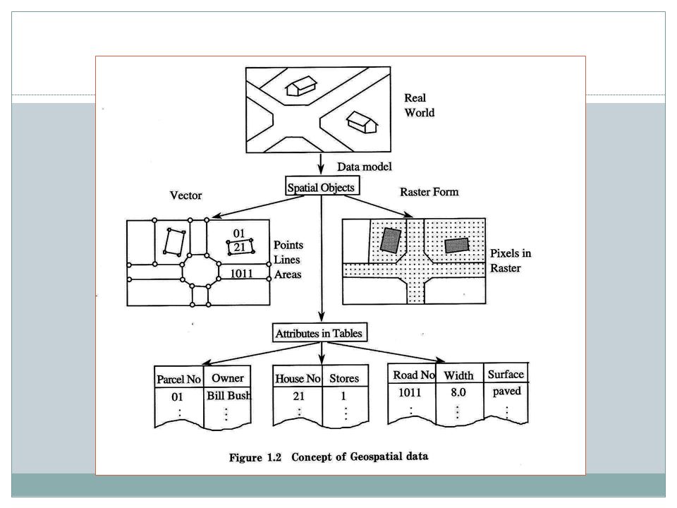
Classification of Geospatial Data Graphical data (called geometric data) Attributes (called thematic data)
 Attributes (called thematic data)")
8
Components of GIS Key components of GIS are: Computer system, geospatial data, and users Sources of geospatial data are: Digitized maps, aerial photographs, satellite images, statistical tables, and other related documents Computer System Geospatial Data Users Figure: Key components of GIS

10
Classification of Geospatial Data Graphical data (called geometric data) Attributes (called thematic data) Figure: Concept of Geospatial Data Real World VectorVector Raster Form Spatial Objects Attributes in Tables Pixels in Raster Points Lines Areas Data Model
 Attributes (called thematic data) Figure: Concept of Geospatial Data Real World VectorVector Raster Form Spatial Objects Attributes in Tables Pixels in Raster Points Lines Areas Data Model")
11
Why GIS is needed ? Common problems of handing geospatial information: Geospatial data are poorly maintained. Maps and statistics are out of date. Data and information are inaccurate. There is no data retrieval service. There is no data sharing.

12
Benefits once GIS is implemented Geospatial data are better maintained in a standard format. Revision and updating are easier. Geospatial data and information are easier to search, analysis and represent. More value added product. Geospatial data can be shared and exchanged freely. Productivity of the staff improved and more efficient. Time and money are saved. Better decision can be made.

13
Computer System for GIS Hardware System Central Processing Unit (CPU) Memory (RAM) > 64 MB I/O Device Plotters, printers, mouse, digitizers, scanners, digital camera Software System Operating System DOS, Windows Compiler C++, Pascal, Fortran, BASIC Application Programs ArcGIS, MGE, Geo/SQL, GFIS, IDRISI*, GRASS* * public domain software
 Memory (RAM) > 64 MB I/O Device Plotters, printers, mouse, digitizers, scanners, digital camera Software System Operating System DOS, Windows Compiler C++, Pascal, Fortran, BASIC Application Programs ArcGIS, MGE, Geo/SQL, GFIS, IDRISI*, GRASS* * public domain software")
14
Area of GIS Applications AreaGIS Applications Facilities Management Locating underground pipes & cables, planning facility maintenance, telecommunication network services Environmental and Natural Resources Management Environmental impact analysis, disaster management and mitigation Street NetworkLocating houses and streets, car navigation, transportation planning Planning and Engineering Urban planning, regional planning, development of public facilities Land InformationTaxation, zoning of land use, land acquisition

15
What is remote sensing Remote Sensing: remote sensing is science of acquiring, processing, and interpreting images and related data that are obtained from ground-based, air-or space- borne instruments that record the interaction between matter (target) and electromagnetic radiation. Remote Sensing: using electromagnetic spectrum to image the land, ocean, and atmosphere. In this class, we will mostly focus on the principles and techniques for data collection and the interaction of electromagnetic energy with the Earth's surface some application examples also you will get familiar with ENVI, an image processing software.

16
1 2 3 4 5 7 What we measure in remote sensing?

17
Solar radiation

18
Agricultural Efficiency Air Quality Water Management Disaster Management Carbon Management Aviation Ecological Forecasting Invasive Species Coastal Management Homeland Security Energy Management Public Health Applications of National Priority

19
NASA & NOAA jointly funding NRC studies on improving transition NPP NPOESS SeaWiFS TerraAqua Joint Center for Satellite Data AssimilationNCEP Short-term Prediction Research and Transition CenterNWS Observation Data Assim ACRIMsat SORCE Glory NPOESS SAGE IIIAURA NPOESS JasonOSTM NOAA/EUMETSAT Landsat 7 LDCM Operational NPOESS GIFTS* GOES Tropo Winds TBD Imaging and Sounding Solar Irradiance, Ozone, and Aerosols Ocean Surface Topography Land Cover/Land Use Change Tech In Formulation In operation Under Development Atmospheric Composition UARSAURA TBD * Canceled flight mission; gleaning technology for GOES-R Tech Development NPP Research Systems to Operational Systems

20
Trend and Future of Remote Sensing Globe coverage, high repeatability (or improved temporal resolution) - AVHRR, 1100m, morning or afternoon - MODIS, 250-1000m, morning or afternoon - NPOESS (will be launched in 2013), 370-740m, 4 hours Real-time or near real-time availability - MODIS available online in the second day ? - NEXRAD available online in 6 minutes - NPOESS available online in 15 minutes Cost free or affordable - Most of the federal collected images are free available or lower cost, while commercial high resolution images are affordable. Integrated remote sensing and GIS - Remote sensing applications with the support of GIS - Remote sensing data as a major GIS data source

21
4th International Conference on Hydrology & Meteorology-USA 4th International Conference on Hydrology & Meteorology-USA Hydrology: Current Research Related Conferences

22
Hydrology: Current Research Related Journals Journal of Geology & Geosciences Journal of Geophysics & remote Sensing Journal of Geology & Geosciences Journal of Geophysics & remote Sensing

23
OMICS Group Open Access Membership OMICS publishing Group Open Access Membership enables academic and research institutions, funders and corporations to actively encourage open access in scholarly communication and the dissemination of research published by their authors. For more details and benefits, click on the link below: http://omicsonline.org/membership.ph p OMICS publishing Group Open Access Membership enables academic and research institutions, funders and corporations to actively encourage open access in scholarly communication and the dissemination of research published by their authors. For more details and benefits, click on the link below: http://omicsonline.org/membership.ph p

Similar presentations