Download presentation
Presentation is loading. Please wait.

1
CEE 795 Water Resources Modeling and GIS Learning Objectives: List the essential data needed for water resource modeling Identify sources of water resources data in the U.S. and Clark County Handouts: Assignments: Exercise #2 Lecture #3: Data Sources and Projections (some material from Dr. David Maidment, University of Texas) January 30, 2006
 January 30,")
2
http://www.geodata.gov/gos Geospatial One-Stop

3
Google Earth http://earth.google.com/

4
Watersheds of the US 2-digit water resource regions 8-digit HUC watersheds

5
Hydrologic Unit Code Watersheds ~ 2000 for US, about the size of counties

6
Watershed Hierarchy 8 HUC 4 2 6 EDNA 10 12 Available In Progress Digit #

7
Watershed Boundary Dataset National Program by USGS and USDA (NRCS) Boundaries for 10- and 12- digit watersheds First cut is by automated delineation from NED Hand checked and edited 10-digit watersheds
 Boundaries for 10- and 12- digit watersheds First cut is by automated delineation from NED Hand checked and edited 10-digit watersheds")
8
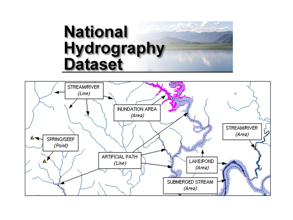
EPA River Reach File 1 (RF1)
")
9
State and Local Data Decisions Watershed Management. TMDL. Source Water Protection. StormwaterDecisions Watershed Management. TMDL. Source Water Protection. Stormwater DataCartographic Monitoring MonitoringLoadingsDataCartographic LoadingsModels HSPF - NPSM HSPF - NPSM QUAL2E QUAL2E TOXIROUTE TOXIROUTEPost-ProcessorsModels HSPF - NPSM HSPF - NPSM QUAL2E QUAL2E TOXIROUTE TOXIROUTEPost-ProcessorsToolsTargetAssessment Data Mining ReportingToolsTargetAssessment Reporting BASINS BASINS - Integrating GIS and Water Quality Modeling Target Assess DM

10
River networks for 8-digit HUC watersheds http://nhd.usgs.gov/

12
Lower West Fork, Trinity River Basin HUC = 12030102

13
NHD River Reaches 412 River Reaches In Upper West Fork of Trinity Basin

14
River Reach Codes Used for river address locations ReachCode = 12030102000151 ReachCode = 12030102000005 HUC# Segment# Location 0.392 on Reach 12030102000005

16
National Elevation Dataset Digital Elevation Model with 1 arc- second (30m) cells Seamless in 1° blocks for the United States 10 billion data Derived from USGS 1:24,000 quadrangle sheets http://seamless.usgs.gov/Get the data: http://gisdata.usgs.net/ned/
 cells Seamless in 1° blocks for the United States 10 billion data Derived from USGS 1:24,000 quadrangle sheets the data:")
17
Digital Elevation Model (DEM) Contours 720 700 680 740 680700720740 720
 Contours")
18
Austin West 30 Meter DEM

19
http://www.ngdc.noaa.gov/mgg/shorelines/shorelines.html

20
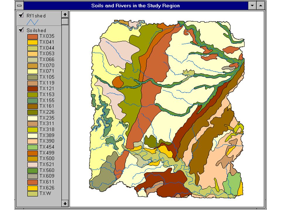
http://www.ncgc.nrcs.usda.gov/products/datasets/statsgo/ 1:250,000 Scale Soil Information

22
County Level Digital Soil Maps 1:24,000 scale soil information http://www.ncgc.nrcs.usda.gov/products/datasets/ssurgo/

23
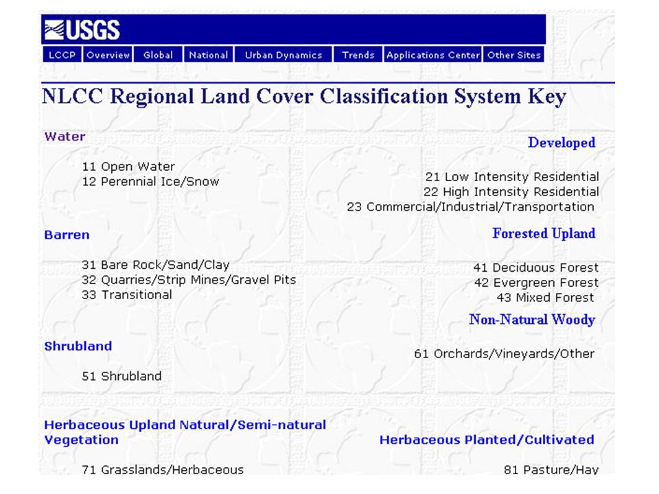
National Land Cover Dataset http://landcover.usgs.gov/nationallandcover.html http://seamless.usgs.gov/Get the data:

24
Hydrologic Landscape Regions USGS Characterization of nature of soil and groundwater systems

26
http://www.ncdc.noaa.gov/oa/ncdc.html

27
PRISM Mean Annual Precipitation http://www.wcc.nrcs.usda.gov/climate/prism.html

28
http://www.daymet.org/

29
National Water Information System Web access to USGS water resources data in real time http://waterdata.usgs.gov/usa/nwis/

30
USGS Water Watch Web access to USGS water resources data in real time http://waterdata.usgs.gov/nwis/rt

31
USGS National Water Information System. Real-time and Historic Data –Streamflow and stage –Groundwater levels –Water Quality –Site information Tabular or Graphical Format

32
http://srtm.usgs.gov/

33
http://www.geographynetwork.com/

34
GTOPO30 - 1 km Digital Elevation Model of the Earth http://edcdaac.usgs.gov/gtopo30/gtopo30.html

35
Drainage in North America http://edcdaac.usgs.gov/gtopo30/hydro/index.html Hydro1K is derived from GTOPO30 using raster GIS analysis

36
NASA Satellite Data http://edcimswww.cr.usgs.gov/pub/imswelcome/

37
Global Energy and Water Experiment http://www.gewex.org/

39
http://maps.utah.gov/

40
http://www.wrcc.dri.edu/

41
http://www.wcc.nrcs.usda.gov/snotel/

42
Clark County Data Clark County GIS Management Office (GISMO)
")
43
Clark County Data Flood Threat Recognition System

Similar presentations


 fusion into DEM raster (burning in) - Sink removal - Flow direction - Flow.>")


 January 18, 2006 Learning Objectives:>")

. The Coquille River is the major.>")


