Download presentation
Presentation is loading. Please wait.

1
Space for Geo-information (RGI): Connecting worlds! Jacqueline Meerkerk Workshop SDI Assessments, Wageningen, 24 May 2007

2
Overview presentation 1. What is RGI? 2. RGI & NSDI user demands 3. Conclusion

3
1. What is RGI? Lisbon Agenda for EU Investment in knowledge Economy: New knowledge (more innovation) Better flow of knowledge from universities to companies (shorter time to market) Additional budget of 800 M Euro Space for geo-information was funded (20 M Euro)!
 Better flow of knowledge from universities to companies (shorter time to market) Additional budget of 800 M Euro Space for geo-information was funded (20 M Euro)!.")
4
Ambition Better services and citizen interaction Top R&D (internat.) More demand orientation More demand orientation More coherence More awareness More flow of knowledge More flow of knowledge More innovation Enhancement and innovation of the NSDI and the geo- knowledge community Sound and efficient public administration Robust business
 More demand orientation More demand orientation More coherence More awareness More flow of knowledge More flow of knowledge More innovation Enhancement and innovation of the NSDI and the geo- knowledge community Sound and efficient public administration Robust business")
5
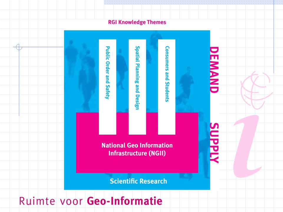
Role RGI: Catalyst for geo-innovation Flow of NSDI knowledge NSDI Knowledge development Catalyst for NSDI implementation

6
Consortium

7
Aspects of the program GI-science and GI-practice 4 Knowledge themes (45 projects and 35 innovation pilots) Total budget 40 M euro (20 M euro new money) From 2004-2009 250 participating organizations (20 international) Similar to Geoide (Canada) en CRC-SI (Australia)
 Total budget 40 M euro (20 M euro new money) From participating organizations (20 international) Similar to Geoide (Canada) en CRC-SI (Australia)")
9
E.g.: Public order and safety 3 projects and 7 innovation pilots A few examples: Mobile services for fire brigades Spatial planning and risk management Real-time data collection & emergency

10
Experiences NSDI is difficult to communicate NSDI is BIG (and dynamic) NSDI awareness is growing Connecting user worlds is difficult but valuable (inspiration & anchoring) “What’s the problem” syndrome Challenge: reducing complexity!
 NSDI awareness is growing Connecting user worlds is difficult but valuable (inspiration & anchoring) What’s the problem syndrome Challenge: reducing complexity!")
11
2. NSDI user demands - Users Why do we need NSDI assessments results? To communicate the benefits of NSDI To make investment decisions Who are potential users of NSDI assessments results? Decision makers (decision making): “GI-Beraad”, GeoManagers, Industry Lobby/ Policymakers (promoting & advise): Policymakers at the Ministries, RGI, GeoNovum, GeoMeeting… Stakeholders in the world of Supply AND Demand
: GI-Beraad , GeoManagers, Industry Lobby/ Policymakers (promoting & advise): Policymakers at the Ministries, RGI, GeoNovum, GeoMeeting… Stakeholders in the world of Supply AND Demand.")
12
RGI & NSDI assessments results Value for RGI: To strengthen the role of catalyst for implementation SDI (To strengthen the scientific output of RGI ) Usability demands Simple & Comprehensive (brochure?) Illustration (what is SDI)? Concrete facts Good and Best practices!

13
RGI & Demands on results Qualitative, quantitative, monetary? Yes Special interest: View on organization roles and their interests Search for the common interest Culture of decision making (Dutch “polder” culture) Benchmarking
 Benchmarking.")
14
RGI & indicators Scientific output Societal output - Sectoral SDI’s - Transparent business model - Use by industry/ # licencies Innovation output Economic output -New user fields, e.g. health - Concrete NSDI vision - % awareness

15
3. Conclusions Users, suggestion: stakeholders in the world of Demand to convince the world of supply Keep it simple Focus on organization roles It’s all about connecting worlds! www.rgi.nlwww.rgi.nl (digital newsletter SynRGI in English!)
.")
Similar presentations


 Outreach overview, Jan 2011 Mark Reichardt, President and CEO Open Geospatial Consortium © 2011 Open Geospatial Consortium.>")


 Why participate ? Industry participation in FP6 What’s.>")


