Download presentation
Presentation is loading. Please wait.

1
Uncertainty Quantification and Visualization: Geo-Spatially Registered Terrains and Mobile Targets Suresh Lodha Computer Science, University of California, Santa Cruz Common consistent representation of multiple views of geo-spatially registered terrains Low uncertainty compression algorithms preserving line features within terrains Visualization of uncertainty of GPS-tracked mobile targets Integration of mobile targets and terrains with geographic databases for decision-making

2
Accomplishments - I Development of GIS infrastructure for context-aware situational visualization Development of GPS infrastructure for mobile visualization Work on consistency and uncertainty issues in mobile situational (GIS-GPS) visualization
 visualization")
3
Accomplishments - II Modeling and quantifying uncertainty –Probability-based uncertainty (collaboration with Pramod Varshney, Syracuse University) –Spatio-temporal GPS uncertainty –Low uncertainty line preserving compression algorithms for terrains (extension from point preserving algorithms from previous year)
 –Spatio-temporal GPS uncertainty –Low uncertainty line preserving compression algorithms for terrains (extension from point preserving algorithms from previous year)")
4
Accomplishments - III Integration of data and uncertainty within a global geospatial system (collaboration with Georgia Tech) Application to –Geospatial visualization –General Aviation Continuing work on –Multimodal interaction (speech) –Database querying –Wireless networks for communicating and visualizing data and information with associated uncertainty –Probability-based uncertainty (collaboration with Pramod Varshney, Syracuse University) –Spatio-temporal GPS uncertainty –Low uncertainty line preserving compression algorithms for terrains (extension from point preserving algorithms from previous year)
 Application to –Geospatial visualization –General Aviation Continuing work on –Multimodal interaction (speech) –Database querying –Wireless networks for communicating and visualizing data and information with associated uncertainty –Probability-based uncertainty (collaboration with Pramod Varshney, Syracuse University) –Spatio-temporal GPS uncertainty –Low uncertainty line preserving compression algorithms for terrains (extension from point preserving algorithms from previous year)")
5
GIS Infrastructure Aerial Imagery (DOQQs) Elevation Data –Digital Elevation Models (DEMs) –LIDAR Data Architectural Drawings Street Maps Schematic Diagrams
 Elevation Data –Digital Elevation Models (DEMs) –LIDAR Data Architectural Drawings Street Maps Schematic Diagrams")
6
GIS Images: Aerial Imagery and LIDAR

7
GIS Images: DEM and AutoCAD

8
GPS Infrastructure Ashtech Z-12/G-12 Sensors –Standalone (1 meter) / Differential (1 cm) –Velocity (.1 knots) –L1/L2 frequency (ionospheric delay correction) –RTK/RTCM messages –10 Hz update rate
 / Differential (1 cm) –Velocity (.1 knots) –L1/L2 frequency (ionospheric delay correction) –RTK/RTCM messages –10 Hz update rate")
9
GPS Receiver Equipment

10
Consistency and Uncertainty in Mobile Situational Visualization Disparate data sources Different data formats Different coordinate systems Different resolutions/ sampling/ sizes Different accuracy Different time stamps Communication time lags

11
Common Consistent Representation: Multiple Views of Terrains Aerial Imagery AutoCAD Drawing LiDAR Data Common Coordinate System Geo-Spatial Registration Accuracy

12
Common Consistent Representation: Multiple Views of Terrains

13
Modeling and Visualizing Uncertainty Probability-based uncertain particle movement GPS-based spatio-temporal uncertainty in particle movement Low uncertainty compression algorithms preserving line features within terrains

14
Algorithmic Computation Compute the probability of target at a point x after time t –Probability at an initial location (p) –Probability of movement along a direction (d) –Probability of speed (s) –Final probability = p * d * s
 –Probability of movement along a direction (d) –Probability of speed (s) –Final probability = p * d * s")
15
Computation of Probabilistic Locational Uncertainty

16
Uncertain Probabilistic Shapes

17
GPS Sources of Uncertainty Measurement Errors –Satellite clock drift, receiver clock drift, satellite location error, atmospheric effects, multipath effect, selective availability GPS Availability Issues GPS Integrity Anomalies and Vulnerability

18
Parameters Mode –Standalone / Differential Environment –Urban / Foliage Movement –Stationary –Moving (Constant Velocity, Random)
")
19
Modeling: Static Data Number of accessible/used satellites –Urban higher than foliage –Standalone same as differential SNR (Signal to Noise Ratio) values –Urban higher than foliage –Standalone same as differential DOP (Dilution of Precision) values –Urban smaller than foliage –Standalone smaller than differential
 values –Urban higher than foliage –Standalone same as differential DOP (Dilution of Precision) values –Urban smaller than foliage –Standalone smaller than differential")
20
Satellite Availability

21
Dilution of Precision Satellite Geometry and Orientation Good satellite geometryPoor satellite geometry

22
SNR Modeling

23
Observations and Analysis: Constant Velocity Data

24
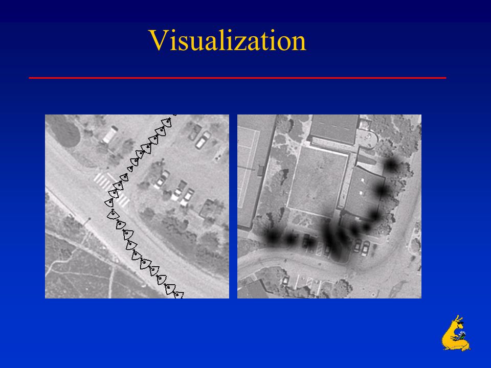
Visualization

26
Terrain Uncertainty Point feature preserving compression algorithms (last year MURI) Line feature preserving compression algorithms –EMD (earth movers distance) concept extended to line features –More efficient local algorithm –Line preservation (coastlines etc.)
 Line feature preserving compression algorithms –EMD (earth movers distance) concept extended to line features –More efficient local algorithm –Line preservation (coastlines etc.)")
27
Topology Degradation Metric EMD ( Rubner et al. ‘98, Batra et al. ‘98, ’99, Lodha et al. 2000 ) –amount of work required to move one set of lines to another (similarity) –Variables # features Location of features Feature Attributes –Length, Orientation
 –amount of work required to move one set of lines to another (similarity) –Variables # features Location of features Feature Attributes –Length, Orientation.")
28
Line EMD Error

29
Line Preserving Compression UnconstrainedCoastline preserving

30
Line Preserving Compression OriginalUnconstrained Coastline preserving

31
Hierarchical Line Simplification

32
Integration of Data and Uncertainty within VGIS Hierarchical zooming from the globe into the UCSC Campus (1/2 foot resolution imagery) Real-time visualization of GPS-tracked objects and associated uncertainty within VGIS
 Real-time visualization of GPS-tracked objects and associated uncertainty within VGIS")
33
Hierarchical Zooming into UCSC Campus

34
Real-Time Mobile Uncertainty Visualization within VGIS

35
Uncertainty Quantification, Visualization and Communication: Continuing Work Heterogeneous Geo-Spatial Uncertainty Mobile Temporal Uncertainty Multi-Sensor Data Fusion (Images, LIDAR) Multi-modal Interaction (speech) Database Querying Wireless Networks
 Multi-modal Interaction (speech) Database Querying Wireless Networks")
36
Collaborations - I Worked with Pramod Varshney on probabilistic uncertain particle movement (1 joint paper and 1 jointly supervised student); continuing to collaborate on uncertainty with mobility constraints Worked with Bill Ribarsky on integration of uncertainty within VGIS (1 joint paper and 1 jointly supervised student); continuing to collaborate on uncertainty in mobile situational visualization
; continuing to collaborate on uncertainty with mobility constraints Worked with Bill Ribarsky on integration of uncertainty within VGIS (1 joint paper and 1 jointly supervised student); continuing to collaborate on uncertainty in mobile situational visualization")
37
Collaborations - II Worked with Ulrich Neumann on development of GPS infrastructure Worked with Avideh Zakhor on acquistion of LIDAR data continuing to collaborate on uncertainty in GPS, LIDAR and image data

38
Major Accomplishments Computation and visualization of uncertainty for terrains while preserving point and line features of terrains, Computation and visualization of uncertain mobile GPS-tracked targets embedded within a GIS Environment, and Embedding and visualization of uncertainty within the VGIS.

Similar presentations


>")