Download presentation
Presentation is loading. Please wait.

1
Introduction to GIS © 2007 Austin Troy Instructor: Austin Troy University of Vermont School of Natural Resources Email: austin.troy@uvm.edu Lecture materials by Austin Troy except where noted. Acknowledgements are due, in particular, to the UC Berkeley GIS Center, where many of the ideas for these lectures evolved in the development of their short course series. NR 143: Introduction to GIS Lecture 1

2
Introduction to GIS © 2007 Austin Troy Source: adapted from UC Berkeley GIS Center What is GIS? (some boring definitions) The complete sequence of components for acquiring, processing, storing and managing data (Star and Estes, 1990) It is a configuration of computer hardware and software specifically designed for the acquisition, maintenance and use of cartographic data, (Tomlin, 1990) It is a set of computer tools for collecting, storing, retrieving at will, transforming and displaying spatial data from the real for a particular set of purposes, (Burrough et al. 1998) A system of hardware, software, data, people, organizations and institutional arrangements for collecting, storing, analyzing and disseminating information about areas of the earth.
 The complete sequence of components for acquiring, processing, storing and managing data (Star and Estes, 1990) It is a configuration of computer hardware and software specifically designed for the acquisition, maintenance and use of cartographic data, (Tomlin, 1990) It is a set of computer tools for collecting, storing, retrieving at will, transforming and displaying spatial data from the real for a particular set of purposes, (Burrough et al. 1998) A system of hardware, software, data, people, organizations and institutional arrangements for collecting, storing, analyzing and disseminating information about areas of the earth..")
3
Introduction to GIS © 2007 Austin Troy Big Picture Concepts Quality

4
Introduction to GIS © 2007 Austin Troy “Clouds are not spheres, mountains are not cones, coastlines are not circles, and bark is not smooth, nor does lightning travel in a straight line.” -Mandelbrot, 1983 A first lesson in GIS:

5
Introduction to GIS © 2007 Austin Troy Core Concepts Quality Scale

6
Introduction to GIS © 2007 Austin Troy Coastline of Britain measurement problem

7
Introduction to GIS © 2007 Austin Troy Core Concepts Quality Scale Documentation and transparency

8
Introduction to GIS © 2007 Austin Troy Important that we know more than just “where?” What is this a map of? Federally owned lands

9
Introduction to GIS © 2007 Austin Troy How about this map? IQ test scores in the UK

10
Introduction to GIS © 2007 Austin Troy What is the heck is this a map of?!! Percent of population that buys salsa

11
Introduction to GIS © 2007 Austin Troy Any clue? Amount of manure created by county

12
Introduction to GIS © 2007 Austin Troy We are used to road maps! GIS maps tell a far more complex story These stories need cliff notes!! METADATA

13
Introduction to GIS © 2007 Austin Troy Approaches to GIS Projects Custom GIS applications Internet Map Servers Client side applications Some examples of GIS in action

14
Introduction to GIS © 2007 Austin Troy Viewshed analysis

15
Introduction to GIS © 2007 Austin Troy Some examples of GIS in Action: Conservation Planning Image by Dave Catts at http://3dnworld.com/galapp.php ?user=DCatts&app=CARTOG

16
Introduction to GIS © 2007 Austin Troy Conservation Planning: Analysis of road disturbance in ecologically important areas Source: Thesis research from Dick Cameron; http://greenwich.colorado.edu/drc/rese.htm

17
Introduction to GIS © 2007 Austin Troy Watershed delineation using digital elevation models

18
Introduction to GIS © 2007 Austin Troy Urban vegetation assessment

19
Introduction to GIS © 2007 Austin Troy Urban Park Planning

20
Introduction to GIS © 2007 Austin Troy Change detection from LANDSAT over 2003 NAIP 1999 Orthophotos with parcel boundaries Estimated 99-02 changed pixels from LANDSAT Land use change detection

21
Introduction to GIS © 2007 Austin Troy Land use change simulation

22
Introduction to GIS © 2007 Austin Troy Shelburne road, circa 1937 2003 Historical analysis

23
Introduction to GIS © 2007 Austin Troy Natural Hazards: Fire Mitigation Decision Support

24
Introduction to GIS © 2007 Austin Troy Natural Hazards: Susceptibility of hillsides to seismically-induced landslides Source: Dissertation research by Bijan Khazai, UC Berkeley,Dept. of Civil Engineering

25
Introduction to GIS © 2007 Austin Troy Market cluster analysis

26
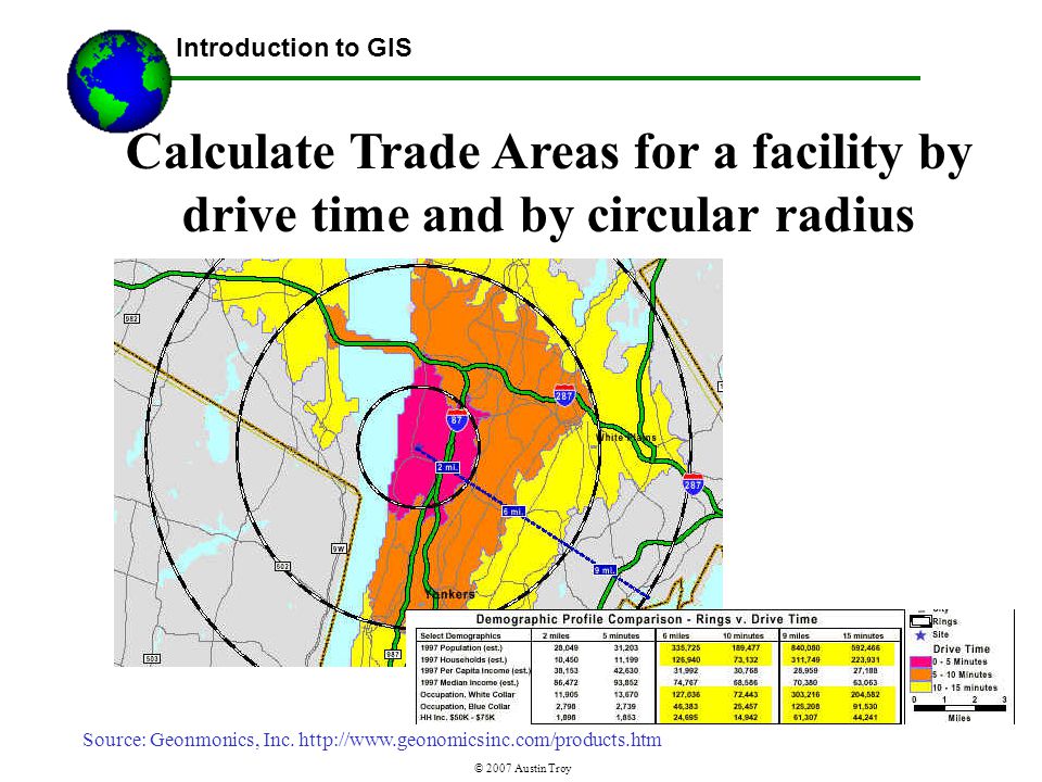
Introduction to GIS © 2007 Austin Troy Calculate Trade Areas for a facility by drive time and by circular radius Source: Geonmonics, Inc. http://www.geonomicsinc.com/products.htm
27
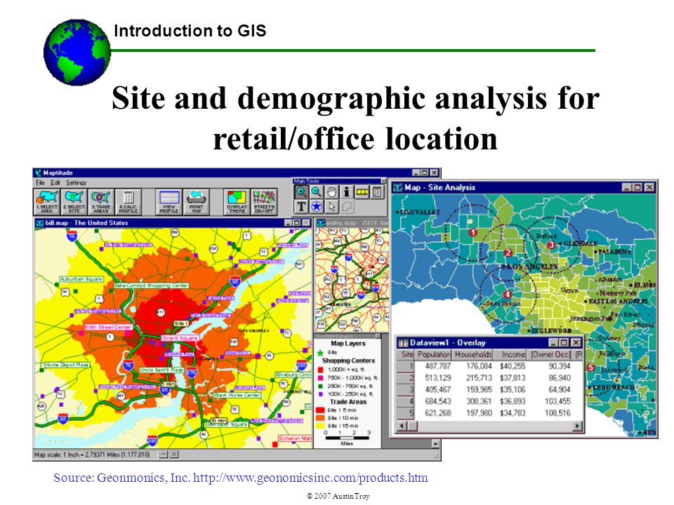
Introduction to GIS © 2007 Austin Troy Site and demographic analysis for retail/office location Source: Geonmonics, Inc. http://www.geonomicsinc.com/products.htm
28
Introduction to GIS © 2007 Austin Troy Transportation: predicting potential transit ridership to help Determine the location of a new transit route Source: UC Berkeley GIS Center

29
Introduction to GIS © 2007 Austin Troy Transportation: Network routing and driving directions Source: Google maps

30
Introduction to GIS © 2007 Austin Troy Drive-time service area

31
Introduction to GIS © 2007 Austin Troy Some examples of GIS in Action: 3 D Visualization for scenario analysis Image by Eric Crews, US Forest Service at http://3dnworld.com/gallery.php?user=ECrews

32
Introduction to GIS © 2007 Austin Troy Some examples of GIS in Action: Visualization of proposed sites Image by Jeff Nighbert, at http://3dnworld.co m/users/40/images/n ighbertblendtest.jpg

33
Introduction to GIS © 2007 Austin Troy Some examples of GIS in Action: 3 D Visualization for development scenario analysis Image by Marco Gualdrini at http://3dnworld.com/ users/27/images/Phase 1OriginalState1.jpg

34
Introduction to GIS © 2007 Austin Troy Some examples of GIS in Action: 3 D Visualization for development scenario analysis Image by Marco Gualdrini at http://3dnworld.com/ users/27/images/Phase 2ActualState1.jpg

35
Introduction to GIS © 2007 Austin Troy Municipal Information Internet Map Server: NaviGate LA

36
Introduction to GIS © 2007 Austin Troy Site Selector Internet Map Server for urban development

Similar presentations


: A Brief Introduction to Network Analysis Parts of the Network Analysis section of this lecture were borrowed from a UC Berkeley.>")


 Fundamentals for Program Managers.>")