Download presentation
Presentation is loading. Please wait.

1
Lunchless Learn First Encounters of the GIS Kind: An Introduction to the Basics of Geographic Information Systems

2
Agenda What is GIS? What is GIS? Planning a trip to San Diego Planning a trip to San Diego The Basics The Basics Q & A Q & A Session Evaluation Session Evaluation

3
What if I have questions? Feel free to ask questions throughout the session – just raise your hand Feel free to ask questions throughout the session – just raise your hand There are no stupid questions There are no stupid questions (trust us!) One voice at a time please! One voice at a time please!
 One voice at a time please. One voice at a time please!.")
4
Geographic Information Systems (GIS) GIS is everywhere! GIS is everywhere! Used everyday Used everyday Used worldwide Used worldwide

5
With GIS you can… Manage the environment Manage the environment Work more efficiently Work more efficiently Provide better customer service Provide better customer service Save money Save money

6
You can use GIS to: Create maps Create maps Find information Find informationHow?Why? Create & edit data Create & edit data Solve problems Solve problems

7
Learning Objectives A student who completes this module will be able to: explore a GIS map and get information about map features explore a GIS map and get information about map features describe the structure of a GIS map describe the structure of a GIS map explain how a GIS represents real-world objects explain how a GIS represents real-world objects access feature information access feature information describe spatial relationships of map features describe spatial relationships of map features describe how GIS can be used to solve problems describe how GIS can be used to solve problems

8
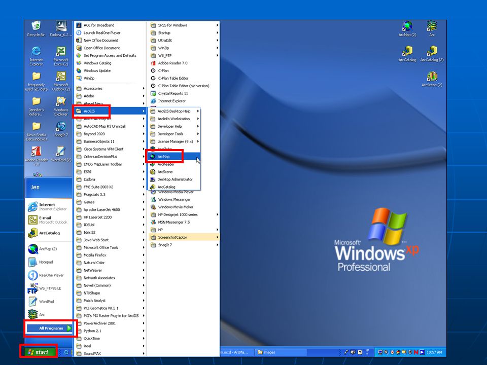
First Encounter with ArcGIS – Planning a Trip to San Diego Step 1 – Start ArcMap Open ArcMap Open ArcMap Click Start Button – All Programs – ArcGIS – ArcMapClick Start Button – All Programs – ArcGIS – ArcMap

10
First Encounter with ArcGIS Step 1 – Start ArcMap Open ArcMap Open ArcMap Click Start Button – All Programs – ArcGIS – ArcMapClick Start Button – All Programs – ArcGIS – ArcMap Open Open c:\temp\VirtualCampus\LearnArcGIS9\ c:\temp\VirtualCampus\LearnArcGIS9\ Start\tourism.mxd

11
Table of Contents Page Layout Window

12
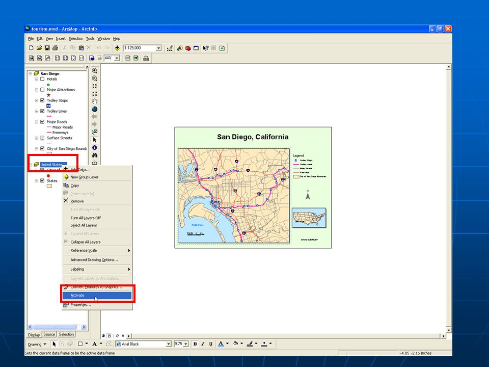
Step 2 – Explore United States Map Activate the United States Map Activate the United States Map Right click on United States in Table of Contents – Choose ActivateRight click on United States in Table of Contents – Choose Activate

14
Step 2 – Explore United States Map Activate the United States Map Activate the United States Map Right click on United States in Table of Contents – Choose ActivateRight click on United States in Table of Contents – Choose Activate Turn on/off State Data Turn on/off State Data Uncheck/check box next to States LayerUncheck/check box next to States Layer

16
Step 3 – Zoom in to San Diego Activate the San Diego Map Activate the San Diego Map Right click on San Diego in Table of Contents – choose ActivateRight click on San Diego in Table of Contents – choose Activate

18
Step 3 – Zoom in to San Diego Activate the San Diego Map Activate the San Diego Map Right click on San Diego in Table of Contents – choose ActivateRight click on San Diego in Table of Contents – choose Activate To see more details of San Diego To see more details of San Diego Zoom in using Zoom In toolZoom in using Zoom In tool

20
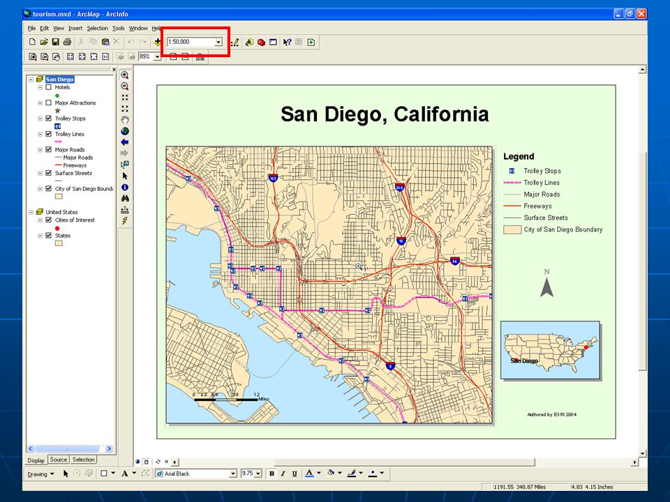
Step 3 – Zoom in to San Diego Activate the San Diego Map Activate the San Diego Map Right click on San Diego in Table of Contents – choose ActivateRight click on San Diego in Table of Contents – choose Activate To see more details of San Diego To see more details of San Diego Zoom in using Zoom In toolZoom in using Zoom In tool With Zoom still active click centre of mapWith Zoom still active click centre of map Type 50000 into the Scale boxType 50000 into the Scale box

22
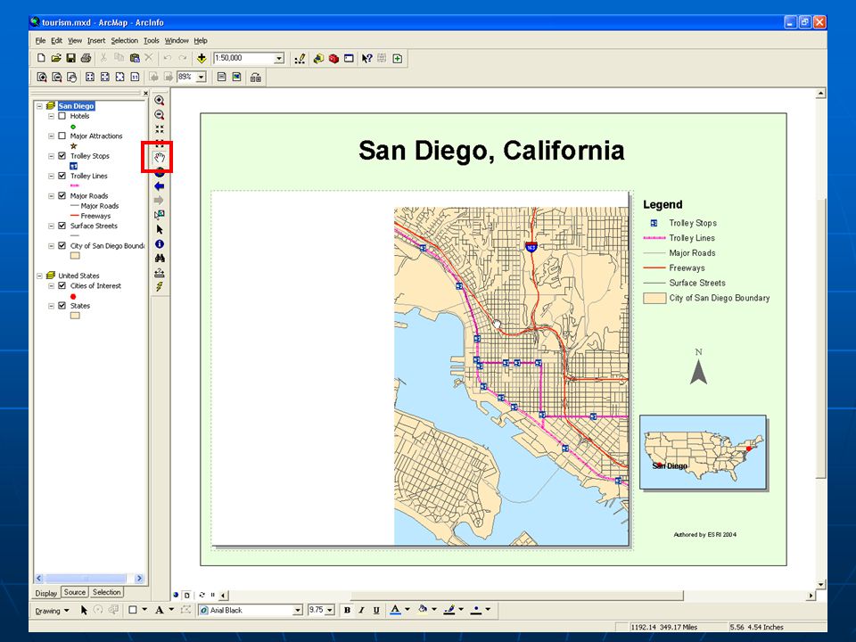
Step 3 – Zoom in to San Diego Activate the San Diego Map Activate the San Diego Map Right click on San Diego in Table of Contents – choose ActivateRight click on San Diego in Table of Contents – choose Activate To see more details of San Diego To see more details of San Diego Zoom in using Zoom In toolZoom in using Zoom In tool With Zoom still active click centre of mapWith Zoom still active click centre of map Type 50000 into the Scale boxType 50000 into the Scale box Use Pan tool and click and dragUse Pan tool and click and drag

24
Step 4 – Switch to Data View and Label Hotels Switch to Data View window Switch to Data View window

26
Step 4 – Switch to Data View and Label Hotels Switch to Data View window Switch to Data View window Turn on Hotels so they are viewed on Map Turn on Hotels so they are viewed on Map Table of Contents – check box next to HotelsTable of Contents – check box next to Hotels Get Hotel name Get Hotel name Zoom into cluster of hotels on coast – click the Select tool and place mouse over hotel symbolZoom into cluster of hotels on coast – click the Select tool and place mouse over hotel symbol

27
HYATT REGENCY HOTEL

28
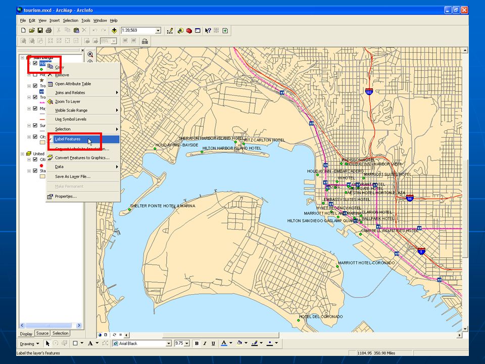
Step 4 – Switch to Data View and Label Hotels Switch to Data View window Switch to Data View window Turn on Hotels so they are viewed on Map Turn on Hotels so they are viewed on Map Table of Contents – check box next to HotelsTable of Contents – check box next to Hotels Get Hotel name Get Hotel name Zoom into cluster of hotels on coast – click the Select tool and place mouse over hotel symbolZoom into cluster of hotels on coast – click the Select tool and place mouse over hotel symbol Turn on the names of all Hotels at once Turn on the names of all Hotels at once Right click on Hotels in Table of Contents – choose Label FeaturesRight click on Hotels in Table of Contents – choose Label Features

30
Step 5 – Find Hotel and get Information about it Find all Marriott Hotels in San Diego Find all Marriott Hotels in San Diego Click Find tool – In Find Field type Marriott - Click dropdown arrow next to In and choose Hotels – Click FindClick Find tool – In Find Field type Marriott - Click dropdown arrow next to In and choose Hotels – Click Find

32
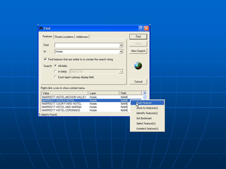
Step 5 – Find Hotel and get Information about it Find all Marriott Hotels in San Diego Find all Marriott Hotels in San Diego Click Find tool – In Find Field type Marriott - Click dropdown arrow next to In and choose Hotels – Click FindClick Find tool – In Find Field type Marriott - Click dropdown arrow next to In and choose Hotels – Click Find Find Marriott Suites Hotel on Map Find Marriott Suites Hotel on Map Right click on Marriott Suites Hotel – Click Flash FeatureRight click on Marriott Suites Hotel – Click Flash Feature

34
Step 5 – Find Hotel and get Information about it Find all Marriott Hotels in San Diego Find all Marriott Hotels in San Diego Click Find tool – In Find Field type Marriott - Click dropdown arrow next to In and choose Hotels – Click FindClick Find tool – In Find Field type Marriott - Click dropdown arrow next to In and choose Hotels – Click Find Find Marriott Suites Hotel on Map Find Marriott Suites Hotel on Map Right click on Marriott Suites Hotel – Click Flash FeatureRight click on Marriott Suites Hotel – Click Flash Feature Get Telephone number of Hotel Get Telephone number of Hotel In Find Dialogue right click Marriott Hotel and Marina – choose Identify FeatureIn Find Dialogue right click Marriott Hotel and Marina – choose Identify Feature

36
Step 5 – Find Hotel and get Information about it Find all Marriott Hotels in San Diego Find all Marriott Hotels in San Diego Click Find tool – In Find Field type Marriott - Click dropdown arrow next to In and choose Hotels – Click FindClick Find tool – In Find Field type Marriott - Click dropdown arrow next to In and choose Hotels – Click Find Find Marriott Suites Hotel on Map Find Marriott Suites Hotel on Map Right click on Marriott Suites Hotel – Click Flash FeatureRight click on Marriott Suites Hotel – Click Flash Feature Get Telephone number of Hotel Get Telephone number of Hotel In Find Dialogue right click Marriott Hotel and Marina – choose Identify FeatureIn Find Dialogue right click Marriott Hotel and Marina – choose Identify Feature Select Hotel Select Hotel Find Dialogue - Right click on Marriott Hotel and Marina - Choose Select FeatureFind Dialogue - Right click on Marriott Hotel and Marina - Choose Select Feature

38
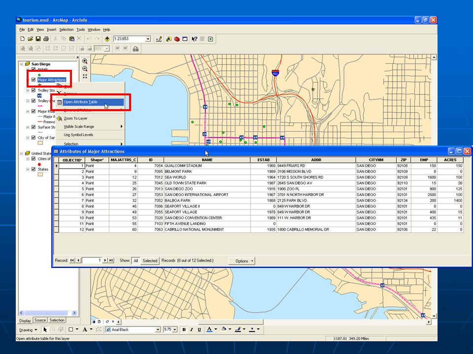
Step 6 – Get Info on Major Attractions Show Major Attractions Show Major Attractions Table of Contents – Check Major Attractions – right click choose Open Attribute TableTable of Contents – Check Major Attractions – right click choose Open Attribute Table

40
Step 6 – Get Info on Major Attractions Show Major Attractions Show Major Attractions Table of Contents – Check Major Attractions – right click choose Open Attribute TableTable of Contents – Check Major Attractions – right click choose Open Attribute Table Sort Table Sort Table Scroll through attributes – Right click on Name field – choose Sort AscendingScroll through attributes – Right click on Name field – choose Sort Ascending

42
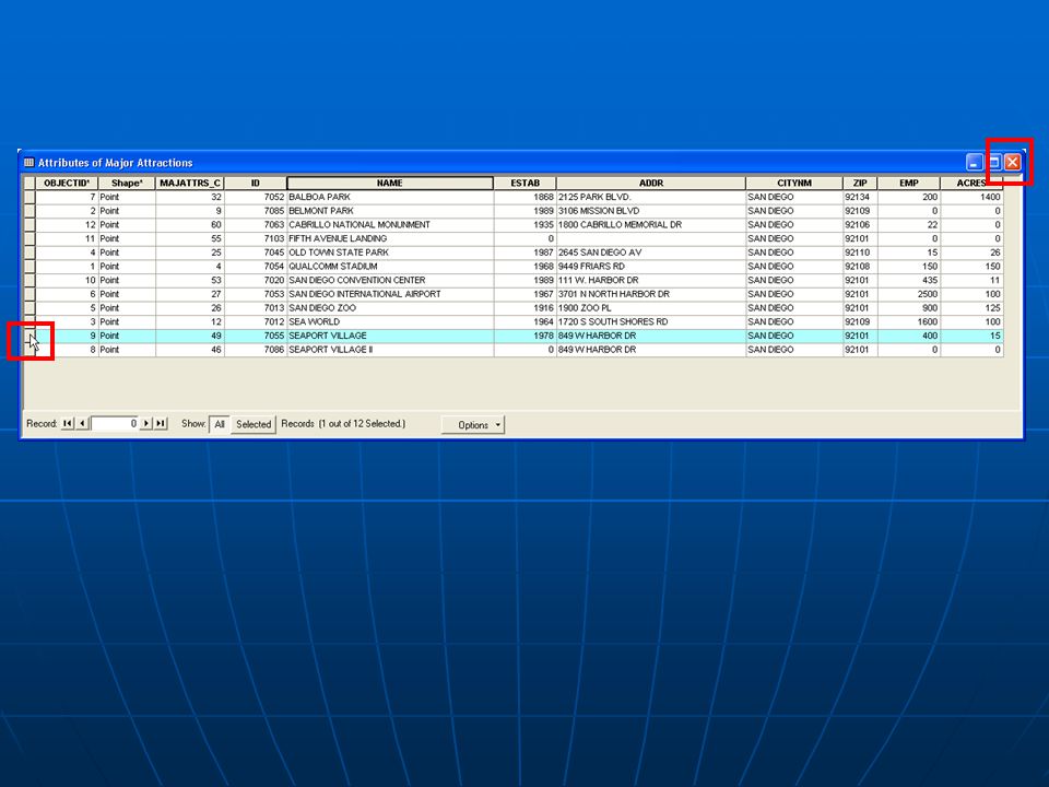
Step 6 – Get Info on Major Attractions Show Major Attractions Show Major Attractions Table of Contents – Check Major Attractions – right click choose Open Attribute TableTable of Contents – Check Major Attractions – right click choose Open Attribute Table Sort Table Sort Table Scroll through attributes – Right click on Name field – choose Sort AscendingScroll through attributes – Right click on Name field – choose Sort Ascending Find Seaport Village Find Seaport Village Scroll through list until you find Seaport Village – click grey box left of recordScroll through list until you find Seaport Village – click grey box left of record Close Table Close Table

44
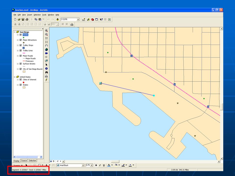
Step 7 – Measure Distance Between Features Zoom into area with Hotel and Seaport Village Zoom into area with Hotel and Seaport Village Measure Distance Measure Distance Click Measure Tool - single click on Marriott Hotel and Marina – move mouse over Seaport Village – double click and check distanceClick Measure Tool - single click on Marriott Hotel and Marina – move mouse over Seaport Village – double click and check distance

46
Step 8 – Find Attractions and Determine Method of Transportation Clear Selected Features Clear Selected Features Selection menu – choose Clear Selected FeaturesSelection menu – choose Clear Selected Features

48
Step 8 – Find Attractions and Determine Method of Transportation Clear Selected Features Clear Selected Features Selection menu – choose Clear Selected FeaturesSelection menu – choose Clear Selected Features Show map of San Diego Show map of San Diego View menu – Bookmarks – San Diego CityView menu – Bookmarks – San Diego City Turn off Major Roads Turn off Major Roads Table of Contents – Uncheck Major RoadsTable of Contents – Uncheck Major Roads

50
Step 8 – Find Attractions and Determine Method of Transportation Clear Selected Features Clear Selected Features Selection menu – choose Clear Selected FeaturesSelection menu – choose Clear Selected Features Show map of San Diego Show map of San Diego View menu – Bookmarks – San Diego CityView menu – Bookmarks – San Diego City Turn off Major Roads Turn off Major Roads Table of Contents – Uncheck Major RoadsTable of Contents – Uncheck Major Roads Label Major Attractions Label Major Attractions Table of Contents – right click Major Attractions – choose Label FeatureTable of Contents – right click Major Attractions – choose Label Feature

52
Step 8 – Find Attractions and Determine Method of Transportation Clear Selected Features Clear Selected Features Selection menu – choose Clear Selected FeaturesSelection menu – choose Clear Selected Features Show map of San Diego Show map of San Diego View menu – Bookmarks – San Diego CityView menu – Bookmarks – San Diego City Turn off Major Roads Turn off Major Roads Table of Contents – Uncheck Major RoadsTable of Contents – Uncheck Major Roads Label Major Attractions Label Major Attractions Table of Contents – right click Major Attractions – choose Label FeatureTable of Contents – right click Major Attractions – choose Label Feature Get details on the closest Trolley Stops Get details on the closest Trolley Stops Click Identify tool - Layer Dropdown choose Trolley Stops – on map click stop closest to Qualcomm Stadium – close Identify windowClick Identify tool - Layer Dropdown choose Trolley Stops – on map click stop closest to Qualcomm Stadium – close Identify window

54
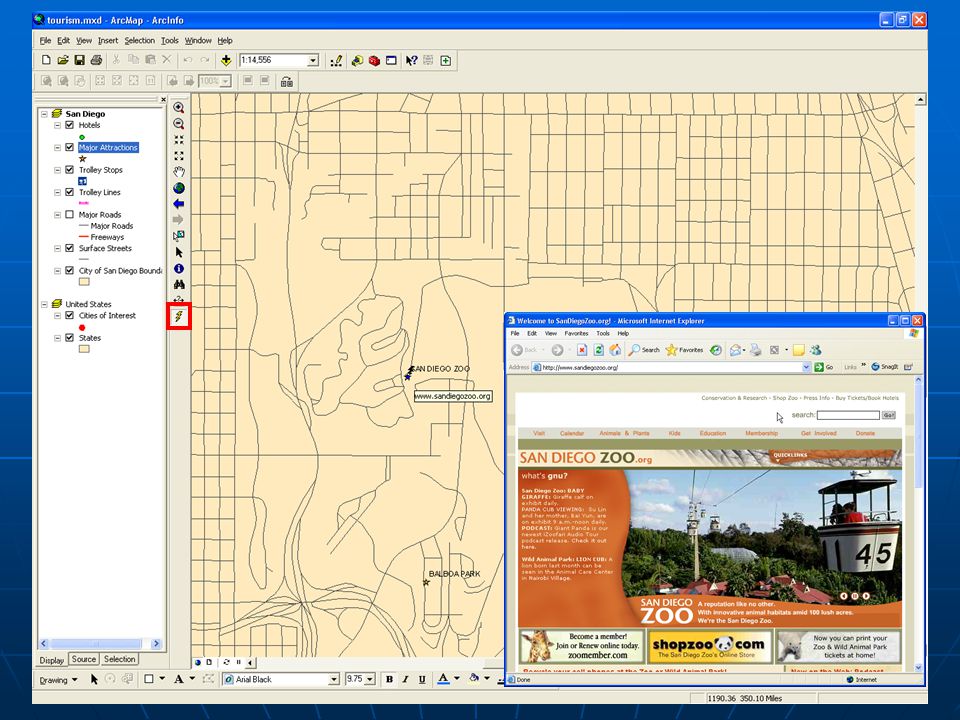
Step 9 – Use Hyperlink for San Diego Zoo Website Zoom to San Diego Zoo Zoom to San Diego Zoo Find San Diego Zoo – Zoom in toolFind San Diego Zoo – Zoom in tool Access San Diego Website info through Hyperlink Access San Diego Website info through Hyperlink Click Hyperlink tool - click on San Diego Zoo symbol on mapClick Hyperlink tool - click on San Diego Zoo symbol on map

56
Step 10 – End ArcMap Session Close ArcMap Close ArcMap File menu – choose Exit – Click no when asked if you want to save dataFile menu – choose Exit – Click no when asked if you want to save data

58
Exploring a GIS map Dynamic Dynamic Zoom, pan, resize Zoom, pan, resize Add/remove features Add/remove features Change symbolization Change symbolization Access database of information Access database of information

59
How is a GIS map organized? Data frames Data frames Thematic layers Thematic layers Features Features

60
How is a GIS map organized? Features have: Location Location Shape Shape Symbol Symbol Features grouped in a layer have: Same shape Same shape Same characteristics Same characteristics AND they are located within the same geographic extent

61
Layers Contain features located within the same boundary Contain features located within the same boundary Each represents a distinct "theme" Each represents a distinct "theme" Are drawn on top of each other to create an informative GIS map Are drawn on top of each other to create an informative GIS map

62
Representing the real world PointLinePolygon One coordinate pair Sequence of 2 or more coordinate pairs One or more lines whose start and end coordinate pairs are the same GIS world – 3 types of features:

63
Representing the real world In this map of South America… What are countries represented as? What are countries represented as? Rivers? Rivers? Cities? Cities?

64
Representation* PolygonsLinesPoints objects with boundaries objects with boundaries countries, building footprints, lakes countries, building footprints, lakes objects too narrow to be polygons objects too narrow to be polygons streets, rivers, telephone lines streets, rivers, telephone lines objects too small to be polygons objects too small to be polygons cities, trees, hospitals cities, trees, hospitals * Depends on map scale

65
Linking features to information For a road For a city - Name - Speed - Direction (one-way or two- way) - Population - Average monthly temperature - Number of schools More than just location and shape Information associated with feature More than just location and shape Information associated with feature
 - Population - Average monthly temperature - Number of schools More than just location and shape Information associated with feature More than just location and shape Information associated with feature")
66
Feature attributes Types or categories of information Types or categories of information Stored in attribute table Stored in attribute table Each feature is a record (row); Each attribute is a column or field Each feature is a record (row); Each attribute is a column or field Same layer, same attribute table Same layer, same attribute table
; Each attribute is a column or field Each feature is a record (row); Each attribute is a column or field Same layer, same attribute table Same layer, same attribute table")
67
Feature attributes This attribute table for a layer of cities stores each feature's ID number, shape, name, the country in which it's located, and its status. This attribute table for a layer of cities stores each feature's ID number, shape, name, the country in which it's located, and its status.

68
Feature attributes Features are linked to attributes by a unique numerical identifier (ID) Features are linked to attributes by a unique numerical identifier (ID) Every feature has an ID Every feature has an ID One-to-one relationship between feature, identifier and attribute record One-to-one relationship between feature, identifier and attribute record
 Features are linked to attributes by a unique numerical identifier (ID) Every feature has an ID Every feature has an ID One-to-one relationship between feature, identifier and attribute record One-to-one relationship between feature, identifier and attribute record")
69
Feature attributes cont’d Click feature on map – see attributes in table Click feature on map – see attributes in table Select record in table – selects feature on map Select record in table – selects feature on map Ask questions of attribute table – display answer on map Ask questions of attribute table – display answer on map

70
Example The city of Bombay is selected. Its record is also selected in the attribute table. The unique identifier for Bombay is stored in the FID field. The city of Bombay is selected. Its record is also selected in the attribute table. The unique identifier for Bombay is stored in the FID field.

71
Understanding Map Scale Scale - the relationship between size on the map and size in the real world Expressed as a ratio, or representative fraction (RF) Expressed as a ratio, or representative fraction (RF) A scale of 1:50,000 means one unit on the map equals 50,000 units on earth. It also means that the objects on earth are 50,000 times larger than the features on the map.

72
Map Scale Two types: Large-scaleSmall-scale Examples? Covers a small area in more detail Covers a large area in less detail

73
Map Scale samples

74
Credits This demonstration was created using course materials from ESRI’s Virtual Campus. If you are interested in taking more Virtual Campus courses, please contact the GIS Centre.

75
GIS Centre Located at the back of the Learning Commons on the first floor of the Killam Library Jennifer Milne Jennifer.Milne@dal.ca 494-6719 Jennifer Strang Jennifer.Strang@dal.ca 494-1386

Similar presentations


 732-7188 GIS and Mapping Procedures in ArcMap 9.x Creating an ArcMap Project Editing an ArcMap Project Printing an ArcMap Project.>")


