Download presentation
Presentation is loading. Please wait.

1
Soil

2
I. Physical and Chemical Properties of Soil A. Soil Texture – Relative amounts of sand, clay, and silt in the soil. Gives one of the best indicators of soil quality. B. Once soil percentages are determined the Soil Texture triangle can be used to classify the soil. 1. Loam one of the best soil types for plant growth and agriculture

4
Soil Texture % Sand, Silt, or Clay PorosityPermeability Capacity to Store Nutrients

5
Physical Properties of Soil C. Porosity – The volume of air and water the soil can hold. Porosity is determined by the size of the soil particles. 1. Sand – Large particles, big pores 2. Clay – Small particles, small pores

6
Porosity Sand – Large spaces, high porosity Good Aeration Silt – Medium Spaces, medium porosity Medium Aeration Clay – Small Spaces, small porosity Poor Aeration

7
Physical Properties of Soil D. Permeability – How quickly water can flow through the soil. High permeability – loose and large particles, water infiltrates quickly but soil does not hold moisture. Low permeability compacted small particles, water infiltrates slowly but soil holds moisture well.

8
Permeability Sand – Large spaces, water infiltrates quickly Poor water- holding capacity Silt – Medium Spaces, water infiltrates more slowly Medium water- holding capacity Clay – Small Spaces, water infiltrates slowly Good water- holding capacity

9
E. Soil color = indicates its composition and fertility – Black or dark brown = rich in organic matter – Pale gray or white = indicates leaching of nutrients out of soil

10
Chemical Properties of Soil F. pH – Soil pH influences the availability and solubility of nutrients, and stable, neutral – ish pH is important for soil microbes G. N-P- K – Macronutrients for plants H. Nitrates – nitrogen needed for protein production. Crops with high nitrogen have higher yields and are more nutritious I. Phosphates – phosphorus needed for root, flower, and fruit growth. J. Nitrates and Phosphates are critical components of fertilizer, with some levels of potassium

11
Chemical Properties pH Between 6- 8 is ideal Nitrates 10-25 ppm is ideal Phosphates 2-4 ppm is ideal

12
II. Soil Formation A. Soil consists of mineral matter, organic matter, air, and water 1. Dead and living microorganisms, and decaying material

13
B. Soil formation is slow and complex C. Parent material = the base geologic material of soil 1. Lava, volcanic ash, rock, dunes 2. Bedrock = the continuous mass of solid rock comprising the Earth’s crust

14
D. Weathering = the physical, chemical, or biological processes that break down rocks to form soil!

15
Examples of Weathering Agents Biological WeatheringChemical WeatheringPhysical Weathering Tree roots, lichensWater, acids, gases (sulfur dioxide, acid rain) Wind, rain, thermal expansion and contraction from water freezing Weathering is the primary way soil is formed!
 Wind, rain, thermal expansion and contraction from water freezing Weathering is the primary way soil is formed!")
16
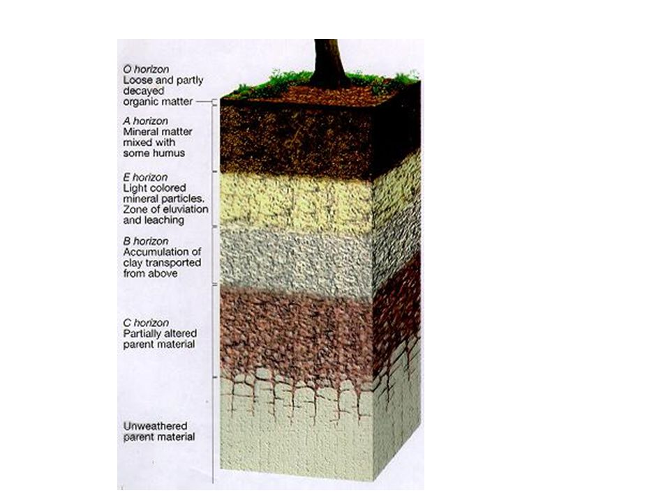
E. A soil profile consists of horizons 1. Horizon = each layer of soil 2. Soil profile = the cross-section of soil as a whole 3. Up to six major horizons may occur in a soil profile - O, A, E, B, C, and R.

17
Copy the layers into your diagram!

19
II. Soil Formation F. Humus = a dark, spongy, crumbly mass of material formed by partial decomposition of organics. Top “O” horizon in soil profile.

20
F. Topsoil = inorganic and organic material most nutritive for plants, found in the second “A” horizon of the soil profile.

21
Soil profile = the cross-section of soil as a whole G. The E horizon is formed in some acidic soils and is a layer of minerals leached from the O and A horizons. H. The B horizon is called the subsoil, and has mostly mineral material and little organic matter. I. The C horizon is the just broken-down parent material, and the R horizon is the bedrock or parent material.

22
II. Soil Formation J. Leaching = dissolved nutrients move down through horizons, via rain, reducing accessibility to plant roots. 1.Huge issue in areas of high precipitation 2.One of the reasons that rainforest soils are so unproductive once agricultural crops are planted 3.Swidden agriculture = cultivation of a tropical plot for a few years and then letting it regrow into forest

23
III. Erosion A. Erosion = the dislodging and movement of soil by wind or water 1. Occurs when vegetation is absent

24
III. Erosion Erosion is just movement of material from one place to another. Streams and rain cause most erosion, but wind is important in soil erosion as well.

25
Erosion degrades ecosystems and agriculture B. Deposition = the arrival of eroded material at its new location C. Flowing water deposits sediment in river valleys and deltas 1. Floodplains are excellent for farming D. Erosion is a problem because topsoil is lost faster than new soil is formed

26
E. Erosion increases through: excessive tilling, overgrazing, clearing forests, and off-road vehicle use F. Soil erosion causes loss of soil fertility through depletion of plant nutrients in topsoil, and water pollution in the form of sediment pollution. G. It is estimated that topsoil is being lost faster than being formed on over 38% of the world’s cropland.

27
H. Soil conservation involves using a variety of ways to reduce soil erosion and restore soil fertility. I. Preventing Erosion can be done improved plowing techniques, planting techniques, and vegetative cover.

28
J. Planting Techniques 1. Crop Rotation = alternating the crops grown field from one season or year to the next, – Cover crops protect soil when main crops aren’t planted

29
2. Intercropping = planting different types of crops in alternating bands or other spatially mixed arrangements – Increases ground cover

30
K. Vegetation 1. Shelterbelts or Windbreaks = rows of trees or other tall, perennial plants that are planted along the edges of fields to slow the wind – Alley cropping = shelterbelts + intercropping

31
2. Planting along waterways: Eroding banks along creeks and roadsides are stabilized by planting plants to anchor soil

32
L. Plowing Techniques 1. Terracing = level platforms are cut into steep hillsides, sometimes with raised edges – A “staircase” to contain water

33
2. Contour Farming = plowing furrows sideways across a hillside, perpendicular to its slope, to prevent gullies

34
Protecting soil: shelterbelts and reduced tillage 3. Conservation Tillage/No- Till Farming = furrows are cut in the soil, a seed is dropped in and the furrow is closed. Eliminates plowing and tilling of the soil. Almost half of U.S. farmland uses no-till farming.

35
Pros and cons of no-till farming Benefits: reduced soil erosion, greater crop yields, enhanced soils Negatives: increased use of herbicides and fertilizers

36
The Dust Bowl – Extreme Soil Erosion Human activities (destroying vegetation that holds soil in place, leaving fields unplanted) accelerates erosion.
 accelerates erosion.")
37
The Dust Bowl Grew wheat, grazed cattle – Removed vegetation A drought in the 1930s made conditions worse Thousands of farmers left their land and had to rely on governmental help

38
IV. Desertification A.Desertification = Productive potential of soil, especially in arid or semiarid land, falls by 10% or more. B.Topsoil degradation from drought and human activities such as removal of vegetation and overgrazing. C.Once productive or semi-productive land turning more desert-like (poor soil, less biomass able to grow).
..")
39
IV. Desertification D. Only in extreme cases does desertification actually lead to a new desert; more commonly it expands boundaries of existing deserts into once fertile land. E. Costs tens of billions of dollars each year – China loses over $6.5 billion/year alone from goat overgrazing – In Kenya, 80% of he land is vulnerable to desertification from overgrazing and deforestation

40
V. Salinization A.Water used for irrigation is a very dilute solution of various salts, picked up as the water flows over rocks and soil. Irrigation water that has not been absorbed into the soil evaporates, leaving behind a thin crust of dissolved salts in the topsoil. B.Repeated irrigation in dry climates leas to the gradual accumulation of salts in top soils, a process called salinization. C.Salinization stunts crop growth, lowers crop yields, eventually kills plants and ruins the land. Salinization effects over 10% of the world’s irrigated cropland, and up to 25% of the U.S.’s irrigated land

41
D. Salinization prevention/mitigation 1. Do not plant water-guzzling crops in arid areas 2. Plant salt-tolerant crops such as barley, cotton, and sugar beet 3. Irrigate with low-salt water 4. Irrigate efficiently, supplying only water that the crop requires – Use drip or micro irrigation

Similar presentations


 A.>")


>")

 anion: atom that forms a negative charge (example: S -2 )>")


 covering bedrock.>")