Download presentation
Presentation is loading. Please wait.

1
Pablo Sastre Olmos Introduction to Geographic Information Systems (GIS) 7 May 2008
 7 May 2008")
2
Geographic Information Systems

3
Mapping criteria must be relevant for the organisms or processes studied

4
1 km Mapa 1:50.000 1 km 1:18.000 1 km 1:6.500 1 x 1 Km UTM 30T VK3796 Analysis at different resolution scales

5
Stream Density (m/ha) at different scales
 at different scales")
6
Analysis at different extents (area of samples)
")
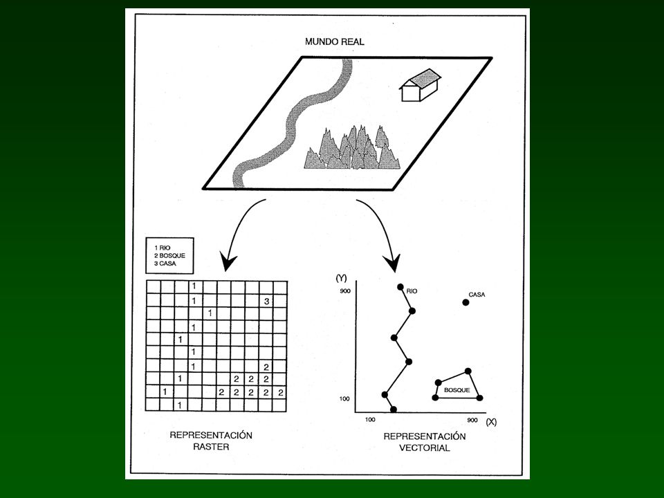
7
Query by attribute: show the location Spatial query: show the attributes

10
Storage of attributes Raster model (digital code)
")
11
Vector model (table associated to objects) Storage of attributes
 Storage of attributes")
13
Raster Digital Terrain Model (DTM) Vector Contour lines (dist.=500m)
 Vector Contour lines (dist.=500m)")
15
Georeferencing Collection Database (Darwin Core): Country = Spain Digital map “Countries-World” (GIS layer with database): Country = Spain Geographic references
: Country = Spain Digital map Countries-World (GIS layer with database): Country = Spain Geographic references")
16
Collection Database (Darwin Core): Country = Spain Digital map “Countries-Europe” (GIS layer with database): Country = Spain Georeferencing Geographic references
: Country = Spain Digital map Countries-Europe (GIS layer with database): Country = Spain Georeferencing Geographic references")
17
Limits Land - Sea: - Continents - Islands, archipelagos Administrative limits: - Countries - Regions - Provinces - Counties - Districts, etc. Streets, roads (post addresses) Rivers, etc. Mountains, etc. ¿What?: Phylum, Species, Sex,... ¿How?: BasisOfRecord, PreparationType ¿Who?: Collector,... ¿When?: YearCollected,... ¿Where?: ContinentOcean Country Province County Locality Longitude Latitude CoordinatePrecision, BoundingBox MaximumElevation, MaxDepth,... Darwin Core Fields Systems of X,Y coordinates Lat./Long. (decimal degrees) UTM (metres, …) Etc. Geographic references
 Rivers, etc. Mountains, etc. ¿What : Phylum, Species, Sex,... ¿How : BasisOfRecord, PreparationType ¿Who : Collector,... ¿When : YearCollected,... ¿Where : ContinentOcean Country Province County Locality Longitude Latitude CoordinatePrecision, BoundingBox MaximumElevation, MaxDepth,... Darwin Core Fields Systems of X,Y coordinates Lat./Long. (decimal degrees) UTM (metres, …) Etc. Geographic references.")
18
Birds Colection – Spanish Museum of Natural Sciences (MNCN-CSIC) Genus Parus Forest Genus Circus Agriculture Madrid / Counties
 Genus Parus Forest Genus Circus Agriculture Madrid / Counties")
20
Historical Data Example: Country = Nueva Granada Virreinato de Nueva Granada (1718-1819) (Colombia, Panamá, Venezuela, Ecuador) República de Nueva Granada (1830-1861) (Colombia, Panamá)
 (Colombia, Panamá, Venezuela, Ecuador) República de Nueva Granada ( ) (Colombia, Panamá)")
21
Dorcadion (J. Lauffer, 1899-1902)
")
Similar presentations


 & ArcView GIS software? What is a Geographical Information System (GIS)? Introduction to ESRI ArcView 3.x.>")


