Download presentation
Presentation is loading. Please wait.

1
Dr. Dan Trent Mississippi Valley State University January 28, 2013

2
1 Present a broad overview of the SURVEYING METHOD 2 Discuss the importance of civil drafting and surveying as professions 3 Introduce basic concepts regarding measurement, computation, and surveying mathematics

3
Surveying involves the measurement of distances and angles. These distances and angles may be horizontal or vertical in direction Angles may also be measured in a horizontal or vertical plane

4
To determine the relative positions of existing points or objects on or near the surface of the earth. To lay out or mark the desired positions of new points or objects that are to be placed or constructed on or near the earth’s surface.

5
Art. Dependent upon the: Skill Judgment Experience of the Surveyor Science Applied Science Field and office procedures rely upon a systematic body of knowledge related primarily to: Mathematics Physics

6
Based on PRECISE measuring instruments in the field And Systematic computational procedures in the office

7
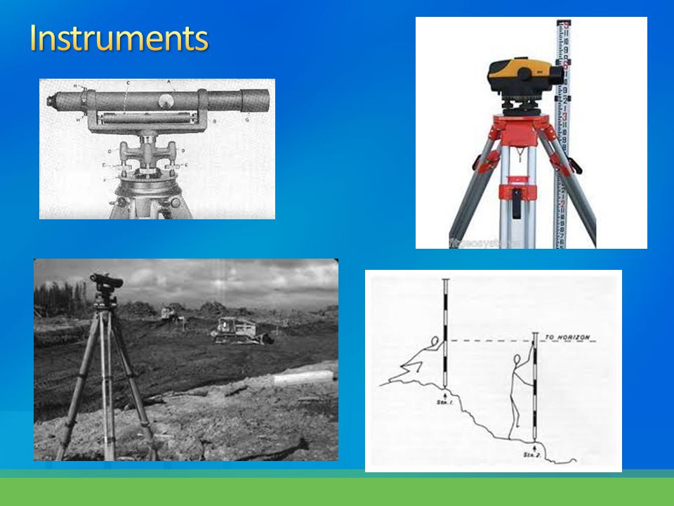
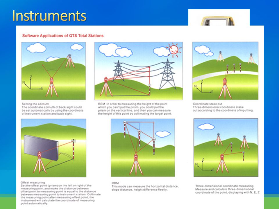
Transit or theodolite Measures angles Level and Level Rod Measures vertical distances Steel Tape Measures horizontal distances These instruments have largely been replaced by electronic recording tacheometer (Total Station)
")
11
Why is surveying an important technical discipline? Essential to planning, design, layout and construction to our physical environment Serves as a link between design and construction Industrial technology (nuclear research, laser technology, etc.)
.")
12
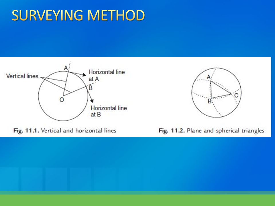
Vertical Direction The direction of gravity – varies based on location Horizontal Direction The direction perpendicular (at an angle of 90 degrees) to the vertical direction of gravity Not a straight line – curves to match the surface of the earth Plumb Line A weight or plumb bob attached to a string
 to the vertical direction of gravity Not a straight line – curves to match the surface of the earth Plumb Line A weight or plumb bob attached to a string")
14
Horizontal Distance or Length Measured along a level surface Vertical Distance Measured along the direction of gravity Equivalent to difference in height between two points When the height is measured with reference to a given level surface (such as mean sea level) it is called an ELEVATION
 it is called an ELEVATION")
15
Leveling The relative vertical positions of several points separated by long distances can be determined by a continuous series of level rod observations The line of sight of the level is horizontal at each observation

16
Leveling The relative vertical positions of several points separated by long distances can be determined by a continuous series of level rod observations The line of sight of the level is horizontal at each observation

17
Transit Theodolite

18
PLANE SURVEYING Basic assumption is that the surface of the earth is perfectly flat and horizontal Neglect the curvature of the earth Use principles of plane geometry and plane trigonometry to compute results of our surveys

19
GEODETIC SURVEYING A survey that takes the earth’s curvature into account Used by government (i.e. U.S. Geologic Survey, U.S. National Geodetic Survey, etc.) Do not use Plane Geometry/Trigonometry Plane Geometry the 3 angles of a triangle always add up to 180° Curved Surface Geometry the 3 angles can be more than 180 °
 Do not use Plane Geometry/Trigonometry Plane Geometry the 3 angles of a triangle always add up to 180° Curved Surface Geometry the 3 angles can be more than 180 °.")
20
PROPERTY SURVEY Establishes positions of boundary lines and property corners A.k.a. Land survey, title survey, or boundary survey

21
TOPOGRAPHIC SURVEY Determines relative positions (horizontal and vertical) of existing natural and constructed features on land Ground elevations, bodies of water, vegetation, roads, buildings, etc.
 of existing natural and constructed features on land Ground elevations, bodies of water, vegetation, roads, buildings, etc.")
22
CONSTRUCTION SURVEY Marks the positions of new points on the ground A.k.a. layout survey, location survey

23
CONTROL SURVEY Horizontal Vertical

24
ROUTE SURVEY

25
HYDROGRAPHIC SURVEY RECONNAISSANCE SURVEY PHOTOGRAMMETRIC SURVEY CADASTRAL SURVEY MINE SURVEY BRIDGE SURVEY TUNNEL SURVEY CITY SURVEY

27
Is surveying an independent profession? What is the basic purpose of statewide professional licensure laws http://www.pepls.state.ms.us/pepls/web.nsf/webpages/LN_ER_PAGE_ER?OpenDocument

28
Why is the proper recording of field notes a very important part of surveying practice? What is one of the important rules with regard to survey field note? Why is it so important? List three others

29
Disadvantages of using loose leaf notebooks for recording survey data What general information should a field book contain? What is the basic advantage of using a data collector for recording surveying measurements? Will these devices completely replace conventional field books?

30
Quiz #1 will be available on the course website at 3:00 p.m. on January 29, 2013. Bonus period for early submission will end January 31, 2013 at 5:00 p.m. Drop Dead Deadline is 5:00 p.m. on Friday, February 1, 2013

31
At the TOP of your paper write: AT – 403Your NameWeek 1 Quiz Papers must be word processed using Microsoft WORD Write out each question, then answer it using complete sentences, correct grammar and spelling below each question Use 12 point Ariel or 12 point Times New Roman font, double spaced Email completed paper to Dr. Trent with the subject line heading EXACTLY LIKE THIS: AT 403 – Your Name – Week 1

Similar presentations


addition of altimetry to a planimetric map b)determination of volume using a net of squares 1.>")


