Download presentation
Presentation is loading. Please wait.

1
Ocean Basins Structure of the Oceans From Continental Shelf to Abyssal Depths

2
2 Measuring Depth 85 BC Posidonius ~2km Hemp line and greased lead weight tension Fathoms (6 feet) Piano wire and cannonball w/ winch By 1895 only 7000 measurements to 2000m and 550 to >9000m Echo sounder (depth recorder) 1920s Meteor- mid-Atlantic ridge 1950s detailed mapping of ridges and trenches Heezen and Tharp
 Piano wire and cannonball w/ winch By 1895 only 7000 measurements to 2000m and 550 to >9000m Echo sounder (depth recorder) 1920s Meteor- mid-Atlantic ridge 1950s detailed mapping of ridges and trenches Heezen and Tharp")
3
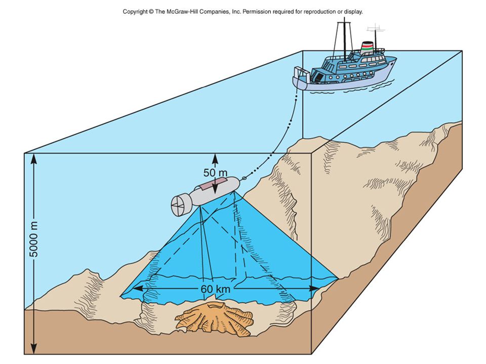
Echo Sounder

4
4 Bathymetry LADS (shallow water) Laser airborne depth sounder Fixed winged aircraft/ GPS Operating depth of 0.5-70m Gravity measurements Changes in sea surface elevation Seamounts +5m and ridges +10m Trenches -25-30m Satellite altimetry Side-scan sonar
 Laser airborne depth sounder Fixed winged aircraft/ GPS Operating depth of m Gravity measurements Changes in sea surface elevation Seamounts +5m and ridges +10m Trenches m Satellite altimetry Side-scan sonar")
5
Marine Gravity Anomalies by Satellite Altimetry

8
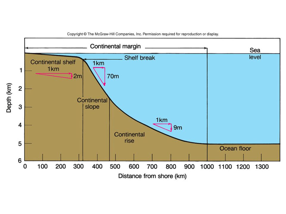
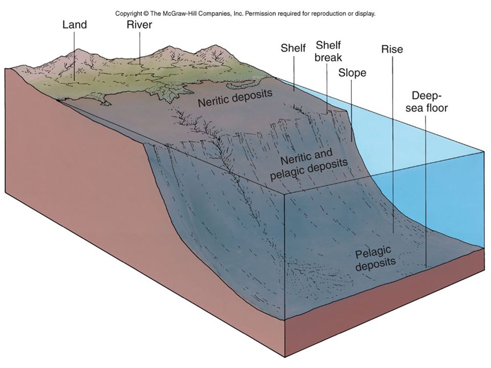
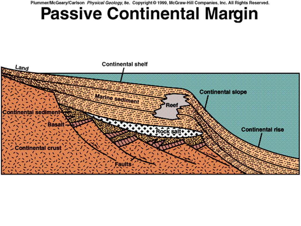
8 Bathymetry of the Sea Floor Continental Margin- Passive and Active Continental shelf (Flat- 10-1500km, 65km; 20- 500m deep) Continental shelf break Continental slope (Steep) Submarine canyons Turbidity currents and turbidites Continental rise Ocean Floor Ridges, Rises and Trenches
 Continental shelf break Continental slope (Steep) Submarine canyons Turbidity currents and turbidites Continental rise Ocean Floor Ridges, Rises and Trenches")
9
Shelf Break Slope Rise Computer Drawn Topographic Profiles Mid- Atlantic ridge

10
Continental Shelves

12
Formation of Shelves by trapping of land derived sediments

14
Turbidity Currents- 90km/hr, 300kg of sed in suspension

15
Submarine Canyon

16
Ancient Turbidite Sequence Bouma Sequence Top- (E)Pelagic Seds (D)Parallel Laminated Sands (C)Rippled, wavy or convoluted laminae (B)Plane Parallel Laminae Bottom-(A)Massive Graded D C A
Pelagic Seds (D)Parallel Laminated Sands (C)Rippled, wavy or convoluted laminae (B)Plane Parallel Laminae Bottom-(A)Massive Graded D C A")
17
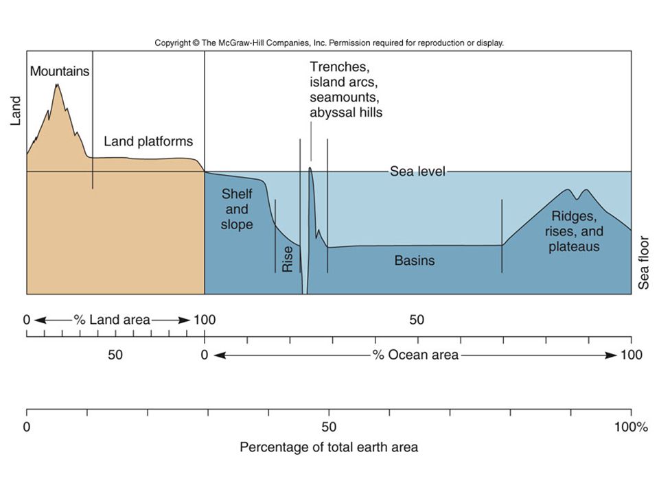
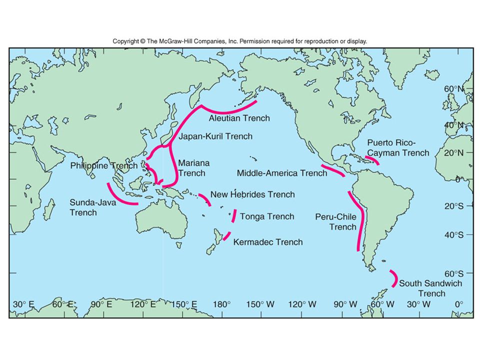
17 Bathymetry of the Sea Floor Ocean Floor Deep seafloor (4000-6000m cover 30% of Earth’s surface) Abyssal Plain (Flat) Pelagic sediments and turbidites Abyssal hills and seamounts & Guyots <1000m high; steep sided volcanoes Found on 50% Atlantic and 80% Pacific seafloor Some become atolls Ridges, Rises and Trenches 65,000km mountain range Challenger Deep (Mariana Trench 11,020m)
 Abyssal Plain (Flat) Pelagic sediments and turbidites Abyssal hills and seamounts & Guyots <1000m high; steep sided volcanoes Found on 50% Atlantic and 80% Pacific seafloor Some become atolls Ridges, Rises and Trenches 65,000km mountain range Challenger Deep (Mariana Trench 11,020m)")
18
Major Ocean Basins

24
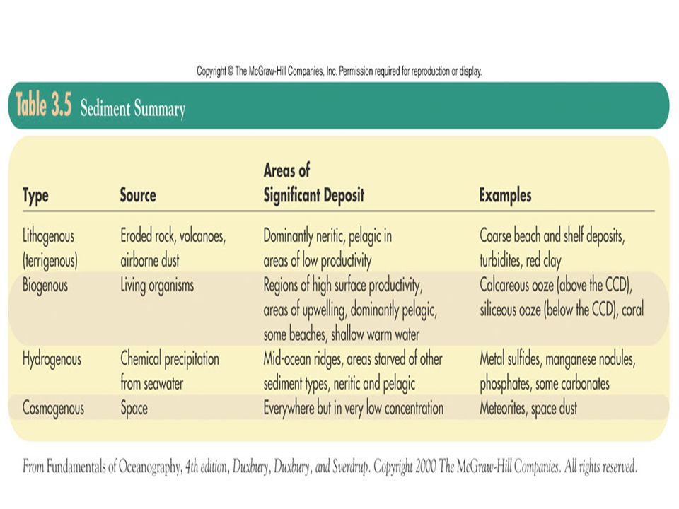
24 Sediments Continental margins and ocean basins receive continuous supply Organic plankton Terrigenous (Land) Rivers, beaches Atmospheric wind Space tektites (meteorites)
 Rivers, beaches Atmospheric wind Space tektites (meteorites)")
26
26 Continental Margin Thick Sequence of sediments (1000’s m) Passive margin Gravels, sands, muds Rates of deposition vary 8m/yr in estuaries 5m/1000yr quiet bays Shelf and slope 10-40cm/1000yrs Carbonates Salts Potential for resources Oil Gas Methane Hydrates
 Passive margin Gravels, sands, muds Rates of deposition vary 8m/yr in estuaries 5m/1000yr quiet bays Shelf and slope 10-40cm/1000yrs Carbonates Salts Potential for resources Oil Gas Methane Hydrates")
27
27 Sand and Gravel 1.2 billion tons/yr Reserves of 800 billion tons US 450 billion tons UK & Japan take 20% from seafloor Other materials found within such as Fe, U, Pt, Au & Diamond The Tin Belt of SE Asia Carbonate sands

29
Oil and Gas account for 95% of material exploited from the sea 24.8% of oil and 20.7% gas in US came from offshore production (1997)
")
30
Gas Hydrates and other Gases Geopressurized zones Methane Hydrates, crystalline solids of gas and water abundant in arctic regions and marine sediments 1 ft 3 releases 160 ft 3 gas Offshore east coast area of potentially 1300 trillion ft 3 gas Reserves 4x10 20 ft 3

32
32 Atmosphere-Wind Winds from deserts transfer terrigenous sediment 1000’s kms into ocean basin Annual supply to oceans 100x10 6 metric tons Sahara-Caribbean connection Reefs Soils

36
Sorting Poorly Well

44
44 Biogenous Sediment Planktonic- Siliceous and Carbonate Oozes Phytoplankton Diatoms (silica) Coccolithosphorids (carbonate) Zooplankton Radiolarians (silica) Foraminefera (carbonate) Lysocline (dissolution) CCD (carbonate compensation depth) <20% preservation CO3 ~4500m Atlantic (5000m) Pacific (4200-4500m); Equatorial Pacific (5000m)
 Coccolithosphorids (carbonate) Zooplankton Radiolarians (silica) Foraminefera (carbonate) Lysocline (dissolution) CCD (carbonate compensation depth) <20% preservation CO3 ~4500m Atlantic (5000m) Pacific ( m); Equatorial Pacific (5000m)")
45
DiatomsCoccolithosphorids

46
Radiolarians

47
Foraminifera

48
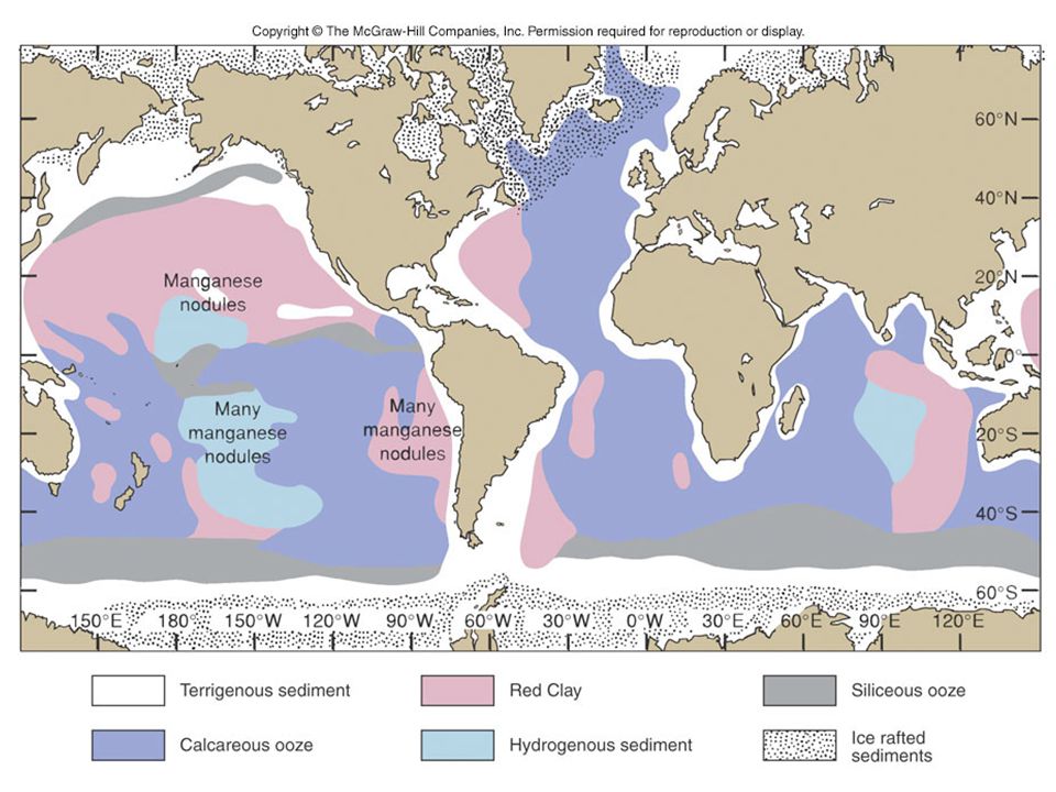
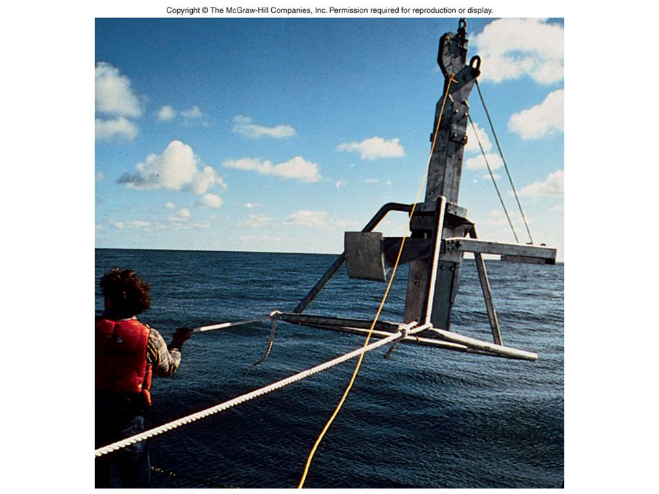
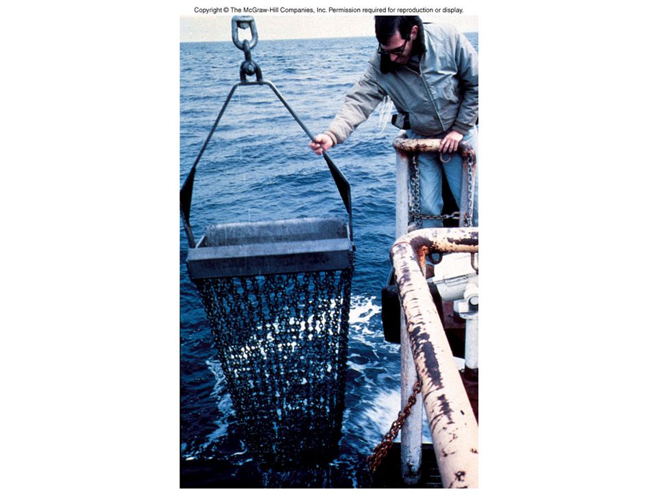
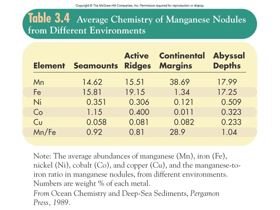
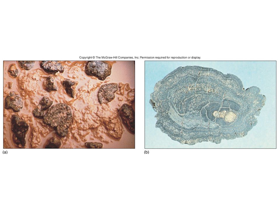
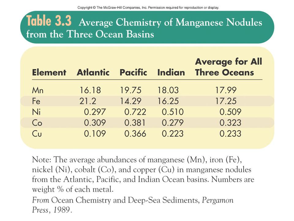
48 Hydrogenous Sediment Slow formation in water column Chemically precipitated Carbonates (ooids, calcareous muds) Phosphorites (fertilizers) Continental shelf and slope Reserve ~ 50 billion tons Nodules or crusts Due to high nutrients-upwelling Salts (Mediterranean) Manganese nodules Concentric layering High in Fe, Cu also 1-10cm diameter Hydrothermal vents (smokers)-ores (sulfides)
 Phosphorites (fertilizers) Continental shelf and slope Reserve ~ 50 billion tons Nodules or crusts Due to high nutrients-upwelling Salts (Mediterranean) Manganese nodules Concentric layering High in Fe, Cu also 1-10cm diameter Hydrothermal vents (smokers)-ores (sulfides)")
49
49 Upwelling When wind blow offshore, they push the warm surface waters away from the coastline This creates a region of low pressure and may result in upwelling of deep water to replace surface water. The deep waters contain dissolved nutrients which can support abundant life at the surface Many fishing grounds exist in these areas, notably the west coast of N. & S. America and w coast of Africa

55
55 Laws and Treaties 200-mile EEZ Law of the Sea (1982) All wealth is shared by humanity Regulated by UN Profits shared US did not sign treaty Provisional Understanding Regarding Deep Seabed Matters (1984)- Western countries (US, UK, Germany, Japan…) 4 consortia awarded exploration licenses
 All wealth is shared by humanity Regulated by UN Profits shared US did not sign treaty Provisional Understanding Regarding Deep Seabed Matters (1984)- Western countries (US, UK, Germany, Japan…) 4 consortia awarded exploration licenses")
56
56 Sediments as Records Paleoceanography Isotopic studies Oxygen isotope ratios in skeletal material to infer past climate ( 18 O: 16 O) Dependant on ratio in seawater During glaciations is 16 O removed, so 18 O: 16 O ratio increases in seawater Marine plankton distribution Circulation models
 Dependant on ratio in seawater During glaciations is 16 O removed, so 18 O: 16 O ratio increases in seawater Marine plankton distribution Circulation models")
Similar presentations


 Go to the syllabus page and click on the Study Guide for Test#1.>")


 Depth = (time x 1500 m/sec)/2 (round trip) At 25 degrees.>")


