Download presentation
Presentation is loading. Please wait.

1
Phases of the Moon Data

2
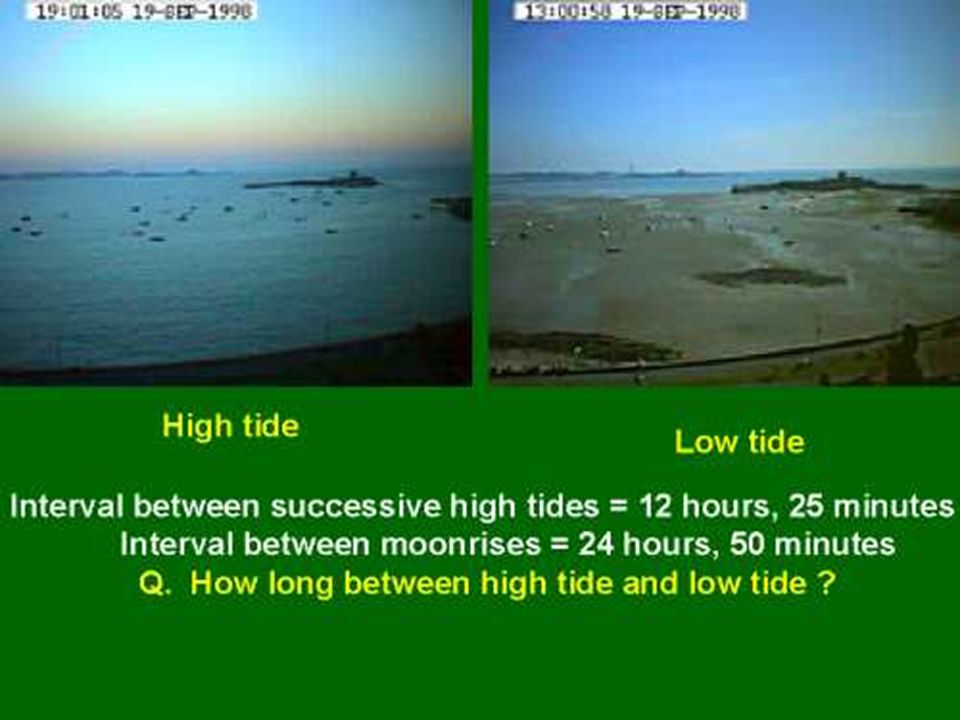
A view of the tides at Halls Harbour on Nova Scotia's Bay of Fundy
A view of the tides at Halls Harbour on Nova Scotia's Bay of Fundy. This is a time lapse of the tidal rise and fall over a period of six and a half hours. During the next six hours of ebb the fishermen unload their boats on the dock. That's a high tide every 12 hours and 25 minutes! There are two high tides every 24 hours and 50 minutes

11
II. Tides A. Earth-Moon system 1. Gravitational attraction

12
Fig. 3.26

13
2. Barycenter II. Tides A. Earth-Moon system
1. Gravitational attraction 2. Barycenter

14
Fig. 3.26

15
3. Centrifugal force II. Tides A. Earth-Moon system
1. Gravitational attraction 2. Barycenter 3. Centrifugal force

16
Fig. 3.26

17
4. Lunar day II. Tides A. Earth-Moon system
1. Gravitational attraction 2. Barycenter 3. Centrifugal force 4. Lunar day

18
Fig. 3.27

19
B. Earth-Moon-Sun system 1. Tidal differences II. Tides
A. Earth-Moon system B. Earth-Moon-Sun system 1. Tidal differences

20
Tidal range

21
gravitational interaction
II. Tides A. Earth-Moon system B. Earth-Moon-Sun system 1. Tidal differences 2. Sun/moon gravitational interaction

22
Fig. 3.28

23
Earth-Moon-sun interaction

25
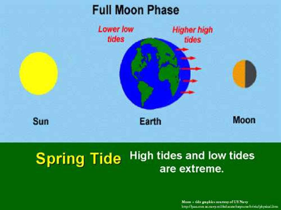
a. Spring tides II. Tides A. Earth-Moon system
B. Earth-Moon-Sun system 1. Tidal differences 2. Sun/moon gravitational interaction a. Spring tides

28
Spring tides

29
b. Neap tides II. Tides A. Earth-Moon system B. Earth-Moon-Sun system
1. Tidal differences 2. Sun/moon gravitational interaction a. Spring tides b. Neap tides

32
Neap tides

38
Tide types Semidiurnal II. Tides A. Earth-Moon system
B. Earth-Moon-Sun system Tide types Semidiurnal

39
Tide types 1. Semidiurnal 2. Diurnal

40
C. Tide types 3. Mixed

41
Fig. 3.30

59
Research information on following slides

60
What causes tides? Tide-generating forces (TGF) are a result of the gravitational attraction between the earth, the sun, and the moon and the centrifugal force due to the relative motions of the moon around the earth, and the earth around the sun. While these forces exactly balance on average, the local mismatch at the earth's surface creates a horizontal force directed towards the surface points closest and farthest from the moon (the "lunar" TGF) and the sun (the "solar" TGF).
 are a result of the gravitational attraction between the earth, the sun, and the moon and the centrifugal force due to the relative motions of the moon around the earth, and the earth around the sun. While these forces exactly balance on average, the local mismatch at the earth s surface creates a horizontal force directed towards the surface points closest and farthest from the moon (the lunar TGF) and the sun (the solar TGF).")
61
The crust of the earth is slightly elastic, so that it is deformed by the TGFs, creating lunar and solar tidal budges (high land) at the points closest and furthest from the moon and sun respectively. To an observer fixed on the earth's surface, these tidal budges move from east to west around the earth as it rotates each day, thus causing two luner and two solar high earth tides about each day. The period of the solar tide is exactly hours, while the period of the lunar tide is slightly longer, hours, due to the moon's revolution around the earth every 27 days. These tides are called the "semidiurnal" tides since they have periods of roughly 1/2 day. The inclination of the earth's spin axis to the plane of the moon's revolution about the earth and the earth's revolution about the sun creates in addition weaker "diurnal" tides with periods of roughly 1 day. The amplitude of the semidiurnal lunar high earth tide is about 1 m at the equator, about twice that of the solar tide. We do not feel these earth tides due to their very large horizontal scales (many 1000's km).
..")
62
The fluid ocean also experiences the TGFs
The fluid ocean also experiences the TGFs. Unlike the simple tidal budges created in the earth's crust, ocean tides have complex spatial patterns due to the complicated shapes and topographies of the different ocean basins. In general, however, ocean tides at any spot consist of a mixture of semidiurnal and diurnal tides. The world's largest semidiurnal tides exist in the Bay of Fundy (maximum high tide ~12-15 m), where the Bay of Fundy/Gulf of Maine acts as a coupled hydrodynamic system which is forced near its own resonant frequency by the semidiurnal tide in the western North Atlantic Ocean. Similar very high tides are found in other coastal areas (e.g., the Amazon and the Patagonia shelves) where the regional topography creates a near-resonant response to the adjacent deep ocean tide.
, where the Bay of Fundy/Gulf of Maine acts as a coupled hydrodynamic system which is forced near its own resonant frequency by the semidiurnal tide in the western North Atlantic Ocean. Similar very high tides are found in other coastal areas (e.g., the Amazon and the Patagonia shelves) where the regional topography creates a near-resonant response to the adjacent deep ocean tide.")
63
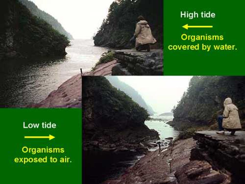
TIDES TIDES Tides are periodic rises and falls of large bodies of water. Tides are caused by the gravitational interaction between the Earth and the Moon. The gravitational attraction of the moon causes the oceans to bulge out in the direction of the moon. Another bulge occurs on the opposite side, since the Earth is also being pulled toward the moon (and away from the water on the far side). Since the earth is rotating while this is happening, two tides occur each day.
. Since the earth is rotating while this is happening, two tides occur each day.")
64
The Sun's Interaction with the Tides Spring Tides Spring tides are especially strong tides (they do not have anything to do with the season Spring). They occur when the Earth, the Sun, and the Moon are in a line. The gravitational forces of the Moon and the Sun both contribute to the tides. Spring tides occur during the full moon and the new moon.

65
The Proxigean Spring Tide is a rare, unusually high tide. This very high tide occurs when the moon is both unusually close to the Earth (at its closest perigee, called the proxigee) and in the New Moon phase (when the Moon is between the Sun and the Earth). The proxigean spring tide occurs at most once every 1.5 years.
 and in the New Moon phase (when the Moon is between the Sun and the Earth). The proxigean spring tide occurs at most once every 1.5 years.")
66
Neap Tides Neap tides are especially weak tides
Neap Tides Neap tides are especially weak tides. They occur when the gravitational forces of the Moon and the Sun are perpendicular to one another (with respect to the Earth). Neap tides occur during quarter moons.
. Neap tides occur during quarter moons.")
67
A lunar eclipse occurs when the Earth's shadow falls on the moon
A lunar eclipse occurs when the Earth's shadow falls on the moon. Lunar eclipses occur, on average, about every 6 months. Types of Lunar Eclipses Total Eclipse - When the entire moon enters the Earth's umbra (the darkest part of its shadow), this is called a total eclipse. Partial Eclipse - When only part of the moon enters the Earth's umbra, this is called a partial eclipse. Duration of Lunar Eclipses During an average total lunar eclipse, the moon is within the Earth's umbra for about an hour. This is called totality. Frequency of Lunar Eclipses Since the plane of the moon's orbit is inclined about 5°: from the plane of the Earth's orbit, lunar eclipses are relatively infrequent. There are about two lunar eclipses each year (visible somewhere on Earth).
, this is called a total eclipse. Partial Eclipse - When only part of the moon enters the Earth s umbra, this is called a partial eclipse. Duration of Lunar Eclipses During an average total lunar eclipse, the moon is within the Earth s umbra for about an hour. This is called totality. Frequency of Lunar Eclipses Since the plane of the moon s orbit is inclined about 5°: from the plane of the Earth s orbit, lunar eclipses are relatively infrequent. There are about two lunar eclipses each year (visible somewhere on Earth).")
68
© 1998, National Institute for Coastal and Marine Management / RIKZ
Information on tides The tide The tide, the motion of ebb and flood in the sea. This is a phenomenon seen by everyone who has ever been to the seashore. Water rises and subsides again just as regularly. For most of us, this rhythm is a fact, a natural occurrence that was always there and always will be. There is a reasonably simple explanation for it, though. As early as the third century BC, Aristotle linked tidal motions to the moon. In 42 AD, Pliny the Elder gave a fairly exact description of the phenomenon and its connection to the sun and the moon. The oldest extant tide tables were compiled by an English monk in the 13th century; but doubtless, some sort of tidal predictions must have existed already in prehistoric times. The word getij in Dutch, the English word tide and the German word Gezeiten all derive from the word time. That itself shows that the tide is inextricably bound up with time, which is logical if we consider that tidal motions are based on the apparent motions of the moon and the sun about the earth. Because the motions of these two celestial bodies are very constant, the rhythm of ebb and flood is too. On the following pages a description is given of how tides begin at sea and what happens on the Dutch coast. This explanation is for the greater part the same as the equivalent chapter in "Het getij & wij". This book (in Dutch) was published by Sdu publishers in the Hague on the occasion of the celebration of the hundredth edition of the "Dutch Tide Tables". The authors are Eric Burgers and Ruud Hisgen of Direct Dutch in the Hague, together with contributors from the National Institute for Coastal and Marine Management/RIKZ. Meanwhile this book is out of print. This account is about ten pages long. You can read right through, which we recommend, or separately, in whatever order you please. © 1998, National Institute for Coastal and Marine Management / RIKZ Last update:
 was published by Sdu publishers in the Hague on the occasion of the celebration of the hundredth edition of the Dutch Tide Tables . The authors are Eric Burgers and Ruud Hisgen of Direct Dutch in the Hague, together with contributors from the National Institute for Coastal and Marine Management/RIKZ. Meanwhile this book is out of print. This account is about ten pages long. You can read right through, which we recommend, or separately, in whatever order you please. © 1998, National Institute for Coastal and Marine Management / RIKZ. Last update:")
69
The Equilibrium Tide The Equilibrium Tide
As early as the 17th century, Newton explained how the tide works. Let us follow him and imagine the earth without continents, covered in water of the same depth everywhere, and only the gravitational force of the moon. The tide occurring in such a situation is called the equilibrium tide. There is a mutual gravitational force between the earth and the moon. This force causes moon and earth to orbit each other in an eclipsic path. Because the earth is much more massive, the common centre of gravity is about 1700 km below the earth’s surface. Relative to this path the attractive force of the moon and the centrifugal force cancel each other out, as far as the earth as a whole is concerned. But, as the diagram shows, this is not the case for specific points on the surface of the earth. On the side of the moon the attractive force exceeds the centrifugal force, on the opposite side it is just the other way round. Due to this, the earth is moulded like a rugby ball, with the two sharp sides facing and averted from the moon. The film of water, which the ocean constitutes, is deformed much more than the solid earth. Due to the rotation of the earth around its own axis, the deformation of this film revolves in the course of a day. In this way, an observer from an island in this hypothetical world-wide ocean would notice each day twice a high water and twice a low water. Newton supposed that the deformation could propagate in such a way that there would be a constant equilibrium of forces everywhere. His theory is, therefore, known as equilibrium theory.

70
Times of Tide Times of Tide
In the previous section we have seen why ebb and flood occur twice a day. But as every true-born marine expert knows, the time between one high tide and the other is not 12 hours, but 12 hours and 25 minutes, i.e. a difference of 50 minutes each day. How can that happen? To find the answer to that we have to take a look at the way in which the moon orbits the earth. The moon orbits the earth along to an elliptic path. After days, the moon has completed one orbit. That orbit is called a tropical lunar month. The moon orbits the earth in the same direction as the direction in which the earth revolves around its axis. After one day, the moon has shifted slightly in its path. A particular point on earth (for instance where there is high tide) is not in the same position relative to the moon as it was 24 hours ago. The earth will have to revolve a bit further to ensure that that point on earth is in the same place relative to the moon. It takes the earth well over 50 minutes to do that. You can calculate this as well. As seen from a distant point in the universe, the earth rotates around its axis in 23 hours and 56 minutes (see the following section) That is approximately 15 degrees per hour (360 degrees divided by 23 hours and 56 minutes). It takes the moon days to orbit the earth once. Therefore the moon shifts approximately 13 degrees per day (360 divided by 27.32). The earth then needs 13/15 hours, which equals about 50 minutes, to catch up with the moon again. Based on a 24-hour day, the moment of high tide shifts an average of 50 minutes each day. With high tide twice a day, it returns on average after 12 hours and 25 minutes.
 is not in the same position relative to the moon as it was 24 hours ago. The earth will have to revolve a bit further to ensure that that point on earth is in the same place relative to the moon. It takes the earth well over 50 minutes to do that. You can calculate this as well. As seen from a distant point in the universe, the earth rotates around its axis in 23 hours and 56 minutes (see the following section) That is approximately 15 degrees per hour (360 degrees divided by 23 hours and 56 minutes). It takes the moon days to orbit the earth once. Therefore the moon shifts approximately 13 degrees per day (360 divided by 27.32). The earth then needs 13/15 hours, which equals about 50 minutes, to catch up with the moon again. Based on a 24-hour day, the moment of high tide shifts an average of 50 minutes each day. With high tide twice a day, it returns on average after 12 hours and 25 minutes.")
71
The earth-sun system The earth-sun system
The moon provides the largest tide-generating force on earth. But the sun, which is 27,000,000 times heavier than the moon, also has a gravitational pull on the earth. Given that the strength of the gravitational pull also depends on the distance between the celestial bodies and that the sun is 389 times further from the earth than the moon, the pull of the sun is only 45% that of the moon. (The reason for this is that the tidal forces are proportional to the mass and inversely proportional to the third power of the distance, therefore: 27,000,000 : 3893 = 27,000,000 : which is approximately 0.45). It takes the earth one year to revolve around the sun. After days the earth has completed one orbit. This orbit is called a tropical year. The orbital direction of the earth around the sun is the same as the direction in which the earth revolves around its own axis. It takes the earth 23 hours and 56 minutes to revolve around its own axis. After this orbit, the earth is not yet in the same position with regard to the sun. Each day the earth revolves about 1 degree further in its path around the sun (360 degrees divided by days). As was explained in the previous screen, the earth revolves about 15 degrees per hour around its own axis. So it still has to go on revolving for 1/15 hour, i.e. 4 minutes, to reach the same position with regard to the sun. It thus takes the earth 23 hours and 56 minutes plus 4 additional minutes, i.e. exactly 24 hours, to return to its original position. This is the day we all know, the average solar day. Consequently, the tide generated by the sun yields a high and a low tide precisely twice each day. But let us go back to the moon for a moment. In the time it takes the moon to pass once through its path around the earth, the earth-moon system has completed part of its path around the sun. That way it takes slightly longer than the days mentioned earlier, that is to say days, before we can see the moon at the same angle vis-à-vis the sun. This cycle is also called the lunar month or the synodic lunar month. © 1998, National Institute for Coastal and Marine Management / RIKZ Last update:
. It takes the earth one year to revolve around the sun. After days the earth has completed one orbit. This orbit is called a tropical year. The orbital direction of the earth around the sun is the same as the direction in which the earth revolves around its own axis. It takes the earth 23 hours and 56 minutes to revolve around its own axis. After this orbit, the earth is not yet in the same position with regard to the sun. Each day the earth revolves about 1 degree further in its path around the sun (360 degrees divided by days). As was explained in the previous screen, the earth revolves about 15 degrees per hour around its own axis. So it still has to go on revolving for 1/15 hour, i.e. 4 minutes, to reach the same position with regard to the sun. It thus takes the earth 23 hours and 56 minutes plus 4 additional minutes, i.e. exactly 24 hours, to return to its original position. This is the day we all know, the average solar day. Consequently, the tide generated by the sun yields a high and a low tide precisely twice each day. But let us go back to the moon for a moment. In the time it takes the moon to pass once through its path around the earth, the earth-moon system has completed part of its path around the sun. That way it takes slightly longer than the days mentioned earlier, that is to say days, before we can see the moon at the same angle vis-à-vis the sun. This cycle is also called the lunar month or the synodic lunar month. © 1998, National Institute for Coastal and Marine Management / RIKZ. Last update:")
72
Spring tide and neap tide
When the sun and the moon are aligned with the earth as it were, they join forces and attract more water. We call this spring tide. In that case, the water level at high tide is higher and at low tide lower. The moon and the sun can also counteract each other. That occurs when the two celestial bodies are at right angles to one another. Then water is attracted from two different sides and as a consequence the water rises far less than average. This phenomenon is called neap tide. Spring tide occurs twice per lunar month (every days). You would expect there to be a spring tide at full moon and at new moon. However, this occurs two days later. Why this is, is explained in a later screen. The orbit of the moon is generally at a certain angle to that of the path of the earth around the sun. Consequently, sun, earth and moon are rarely ever aligned. But when they are, then there is a lunar or a solar eclipse. The solar tide, with a cycle of 12 hours, continually catches up with the lunar tide, which has a cycle of 12 hours and 25 minutes. The effect is that the lunar tide is subjected to fluctuation: it is cyclically reinforced and weakened. It also has an effect on the timing of the tide. Between spring tide and neap tide, the solar tide has a priming effect on the tide, between neap tide and spring tide a retardatory effect.
. You would expect there to be a spring tide at full moon and at new moon. However, this occurs two days later. Why this is, is explained in a later screen. The orbit of the moon is generally at a certain angle to that of the path of the earth around the sun. Consequently, sun, earth and moon are rarely ever aligned. But when they are, then there is a lunar or a solar eclipse. The solar tide, with a cycle of 12 hours, continually catches up with the lunar tide, which has a cycle of 12 hours and 25 minutes. The effect is that the lunar tide is subjected to fluctuation: it is cyclically reinforced and weakened. It also has an effect on the timing of the tide. Between spring tide and neap tide, the solar tide has a priming effect on the tide, between neap tide and spring tide a retardatory effect.")
73
Diurnal inequality Diurnal inequality
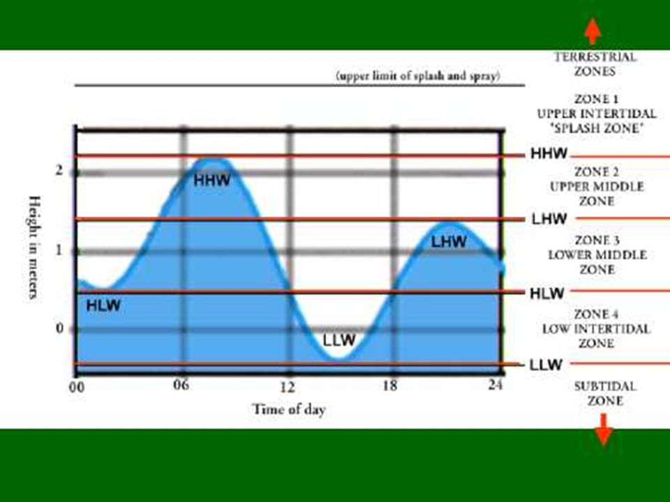
The average angle of the earth's rotational axis in relation to the connecting line between earth and moon is 66.5 degrees. The same applies in relation to the sun. The angle of the terrestrial equator is 23.5 degrees ( ) in relation to the connecting line between earth and moon (and thus earth and sun as well). The ellipsoid of the water mass will be oriented towards the moon. During a complete orbit (one day), someone at a particular spot on the earth will therefore observe two high and two low tides which are unequal in height. This is called diurnal inequality. At certain spring tides, the diurnal inequality is substantial. The subsequent inequality will, on the contrary, be insubstantial. This has to do with the point, or the node, where the lunar path intersects the ecliptic surface. The ecliptic surface is the surface formed by the orbit of the earth and the sun. The sun, earth and moon are then as far as is possible in one plane. The cycle between two nodes is days. This gradually catches up with the lunar month cycle of approximately days. After about 13 lunar months, that is about 376 days, they are level again. Therefore, the inequalities are not systematically larger during either new moon or full moon. In addition to the diurnal inequalities, there are other variations in high and low tide levels. Diurnal inequality The average angle of the earth's rotational axis in relation to the connecting line between earth and moon is 66.5 degrees. The same applies in relation to the sun. The angle of the terrestrial equator is 23.5 degrees ( ) in relation to the connecting line between earth and moon (and thus earth and sun as well). The ellipsoid of the water mass will be oriented towards the moon. During a complete orbit (one day), someone at a particular spot on the earth will therefore observe two high and two low tides which are unequal in height. This is called diurnal inequality. At certain spring tides, the diurnal inequality is substantial. The subsequent inequality will, on the contrary, be insubstantial. This has to do with the point, or the node, where the lunar path intersects the ecliptic surface. The ecliptic surface is the surface formed by the orbit of the earth and the sun. The sun, earth and moon are then as far as is possible in one plane. The cycle between two nodes is days. This gradually catches up with the lunar month cycle of approximately days. After about 13 lunar months, that is about 376 days, they are level again. Therefore, the inequalities are not systematically larger during either new moon or full moon. In addition to the diurnal inequalities, there are other variations in high and low tide levels.
 in relation to the connecting line between earth and moon (and thus earth and sun as well). The ellipsoid of the water mass will be oriented towards the moon. During a complete orbit (one day), someone at a particular spot on the earth will therefore observe two high and two low tides which are unequal in height. This is called diurnal inequality. At certain spring tides, the diurnal inequality is substantial. The subsequent inequality will, on the contrary, be insubstantial. This has to do with the point, or the node, where the lunar path intersects the ecliptic surface. The ecliptic surface is the surface formed by the orbit of the earth and the sun. The sun, earth and moon are then as far as is possible in one plane. The cycle between two nodes is days. This gradually catches up with the lunar month cycle of approximately days. After about 13 lunar months, that is about 376 days, they are level again. Therefore, the inequalities are not systematically larger during either new moon or full moon. In addition to the diurnal inequalities, there are other variations in high and low tide levels. Diurnal inequality. The average angle of the earth s rotational axis in relation to the connecting line between earth and moon is 66.5 degrees. The same applies in relation to the sun. The angle of the terrestrial equator is 23.5 degrees ( ) in relation to the connecting line between earth and moon (and thus earth and sun as well). The ellipsoid of the water mass will be oriented towards the moon. During a complete orbit (one day), someone at a particular spot on the earth will therefore observe two high and two low tides which are unequal in height. This is called diurnal inequality. At certain spring tides, the diurnal inequality is substantial. The subsequent inequality will, on the contrary, be insubstantial. This has to do with the point, or the node, where the lunar path intersects the ecliptic surface. The ecliptic surface is the surface formed by the orbit of the earth and the sun. The sun, earth and moon are then as far as is possible in one plane. The cycle between two nodes is days. This gradually catches up with the lunar month cycle of approximately days. After about 13 lunar months, that is about 376 days, they are level again. Therefore, the inequalities are not systematically larger during either new moon or full moon. In addition to the diurnal inequalities, there are other variations in high and low tide levels.")
74
Variations Variations
Spring tide occurs twice a month, after a new moon and after a full moon. In general, two successive spring tides differ in strength. The main reason for this is the elliptical lunar path. If, during any one spring tide, the moon is close by, then it will as a matter of course be far away at the next spring tide. In the first case, the spring tide is higher than in the second case. As stated before, the moon takes about days to complete its elliptical path around the earth. So it gradually catches up with the cycle of the lunar month, which is about days. After some 15 lunar months, i.e. about 440 days, they coincide again. Therefore, spring tides are not systematically stronger during either new moon or full moon. We can see a variation in spring tide height, the highest spring tide at times being at new moon and at other times at full moon. Both cycles last approximately six months and are produced by the previously described cycle of 440 days and the cycle of 376 days described above. Both cycles are nearly equal to a calendar year. There are all sorts of other cycles brought about by the separate revolutions of the earth and the moon around one another and as a system around the sun. The most important of these are: the 8.85-year cycle which is the result of the fact that the long axis of the ellipse of the moon's path rotates around the earth during this length of time, and the 18.6-year cycle. In this period, the angle at which the moon is in relation to the equator plane of the earth fluctuates between 18.5 degrees and 28.5 degrees. The 23.5 degrees mentioned in the previous screen is an average.

75
The astronomical tide The astronomical tide
Until now we have assumed, together with Newton, that the whole world was covered with water. Our starting point was the so-called equilibrium tide. The real situation is of course more complicated, because as there obviously are land masses on earth and it is not equally covered with water. Continents and islands are obstacles along the way, and the seas are not the same depth everywhere. The only exception is a strip of water in the vicinity of the Antarctic Ocean, at 55 to 65 degrees southern latitude, which is not interrupted by land and where the tidal wave can propagate freely. The locations of the obstacles are, of course, quite stable. On the basis of this situation we may expect a large measure of regularity, including all cycles shown in previous screens. This predictable (and thus calculable) tide is called the astronomical tide. This is also the tide we can find in tide tables. This information can be predicted fairly accurately over a period of years in advance. Changes in the shape of the coastline, for instance the building of dams or the like, can have a disruptive effect. So our tidal motion has its origin in the southern hemisphere. The tidal wave that is generated here flows northwards through the Atlantic Ocean. On its journey, it is variously deformed by the structure of the ocean. After two running days, the tidal wave reaches the Arctic Ocean. In the course of this journey, it undergoes a deflection that is the result of the earth's rotation. This Coriolis Force faces to the right in the northern hemisphere. Apart from that, the Atlantic Ocean is so large that the tidal cycle is about equal to the ocean's own cycle. This way a latitudinal stationary wave arises, as a consequence of which the heights of the tides at the edge of the ocean are higher than would be expected by reason of gravitational pull alone. In reality, in the field so to speak, there are more factors that influence the water height. Atmospheric pressure plays a minor part, while wind force as well as wind direction are of more importance.
 tide is called the astronomical tide. This is also the tide we can find in tide tables. This information can be predicted fairly accurately over a period of years in advance. Changes in the shape of the coastline, for instance the building of dams or the like, can have a disruptive effect. So our tidal motion has its origin in the southern hemisphere. The tidal wave that is generated here flows northwards through the Atlantic Ocean. On its journey, it is variously deformed by the structure of the ocean. After two running days, the tidal wave reaches the Arctic Ocean. In the course of this journey, it undergoes a deflection that is the result of the earth s rotation. This Coriolis Force faces to the right in the northern hemisphere. Apart from that, the Atlantic Ocean is so large that the tidal cycle is about equal to the ocean s own cycle. This way a latitudinal stationary wave arises, as a consequence of which the heights of the tides at the edge of the ocean are higher than would be expected by reason of gravitational pull alone. In reality, in the field so to speak, there are more factors that influence the water height. Atmospheric pressure plays a minor part, while wind force as well as wind direction are of more importance.")
76
Age of the tide Age of the tide
When the tidal wave reaches the North Sea, it has a long journey behind it. It has then already crossed the greater part of the Atlantic Ocean. The time between the origin of the high tide in the Antarctic and its arrival is called the age of the tide. So, depending on where you are, the tide can be young, mature or advanced in age. Off Brest, for example, the tidal wave is about 29 hours old. On the other hand, it takes the tide 52 hours to reach IJmuiden. The reason for this is that it follows a longer route around the British Isles. The tide off the entire Dutch coast is already at least two days old. When the tidal wave is near the British Isles, it enters the North Sea from two different directions. First of all, the wave moves further to the west along the Irish coast and the British coast in a northerly direction and then goes around Scotland. Because the opening is at its largest there, this branch of the tidal wave has the greatest effect in the North Sea. The Coriolis Force compels the current to make a kind of anticlockwise circular motion through the North Sea. The tidal wave then propagates itself along the British coast towards the south and then turns again along the Belgian and Dutch coast in a northerly direction towards Denmark and Norway. Another part of the Atlantic tidal wave approaches the Channel from the south at an average speed of 200 metres per second and is then, to a large extent, blocked. A damming up of the water then takes place, which results in a considerable tidal difference off the coasts of southern England and Normandy. When the current has then squeezed through the Channel, it has by that time lost most of its velocity and force and for that reason it has only a minor influence on the coast of the Netherlands. By making several observations (and assimilating them in mathematical models), lines can been drawn on the North Sea where simultaneous high tides occur. These so-called cotidal lines may be drawn for simultaneous low water, or for equal phases of the separate harmonic constituents, as well. The lines of simultaneous high water in the figure show that there are two points in the North Sea where the lines intersect and around which the tide rotates. At these nodes there is almost no tidal motion at all. They are called amphidromic points.
, lines can been drawn on the North Sea where simultaneous high tides occur. These so-called cotidal lines may be drawn for simultaneous low water, or for equal phases of the separate harmonic constituents, as well. The lines of simultaneous high water in the figure show that there are two points in the North Sea where the lines intersect and around which the tide rotates. At these nodes there is almost no tidal motion at all. They are called amphidromic points.")
77
Tidal ranges along the coast
Because of sea bed configurations, coastal shapes and all sorts of other side effects, the North Sea has a complicated system of tides. Tidal curves from several measuring points along the Dutch coast indicate mutual differences between high and low tide levels. The largest tidal ranges in the Netherlands, approximately 4.80 metres between high and low tide, occur near Bath at the back of the Westerschelde, because of the damming up of the tidal wave in the estuary. From Flushing there is a marked decrease in the tidal range along the coast in a northerly direction. At Den Helder the effect is a minor one because of the proximity of the amphidromic point (see previous page), after which it increases again gradually. The difference in duration of ebb and flow can be calculated from the tidal curves. In Harlingen it takes about 4 hours and 58 minutes before the water is at its highest, but 7 hours and 27 minutes before it is low tide again. So ebb lasts far longer than flood. The same phenomenon can also be observed in other places. The explanation is to be found mainly under water. The tidal wave moves forward at a specific velocity. The deeper the sea, the more freedom of motion there is. During the length of time of ebb and flow, the ocean tide hardly displays any asymmetry. The North Sea, and especially the Waddenzee area, are not so deep, however. If the flow is pushed through between the islands towards Harlingen, then that takes place at full force. The water undergoes considerable resistance from the very shallow Waddenzee sea. When the water has to return at low tide after the flow, then the damming force of the North Sea is no longer there, but the resistance of the sea bed obviously still is. That is why ebb takes much longer to dispose of the water than flow needs to bring it in. Along the Dutch coast and inland on the rivers, a strange phenomenon can be observed. As can be seen from the tidal curve of Hook of Holland (at the beginning, on the left), once the water has reached the lowest level, it remains so for some time. After rising slightly, it then drops again and a second low tide follows. Only then does the water rise quickly and the flood sets in. A slight rise like this followed by a drop is called an agger or a double tide. In Den Helder, the same kind of phenomenon occurs, but this time during high water. The high water is stretched, as it were. Here the term used is not agger but a double high water. The strength of this phenomenon is dependent on time and place. The proximity of the amphidromic point at about 70 km off the coast point explains why at spring tide there is a larger agger and at neap tide a smaller one (see previous page), This point weakens the lunar tide, as a result of which other tide components come into play. Given that the cotidal lines of other tide components are very different to those of the lunar tide, these can cause aggers and the like to occur in certain situations. More information on this subject can be found in the last part.
, after which it increases again gradually. The difference in duration of ebb and flow can be calculated from the tidal curves. In Harlingen it takes about 4 hours and 58 minutes before the water is at its highest, but 7 hours and 27 minutes before it is low tide again. So ebb lasts far longer than flood. The same phenomenon can also be observed in other places. The explanation is to be found mainly under water. The tidal wave moves forward at a specific velocity. The deeper the sea, the more freedom of motion there is. During the length of time of ebb and flow, the ocean tide hardly displays any asymmetry. The North Sea, and especially the Waddenzee area, are not so deep, however. If the flow is pushed through between the islands towards Harlingen, then that takes place at full force. The water undergoes considerable resistance from the very shallow Waddenzee sea. When the water has to return at low tide after the flow, then the damming force of the North Sea is no longer there, but the resistance of the sea bed obviously still is. That is why ebb takes much longer to dispose of the water than flow needs to bring it in. Along the Dutch coast and inland on the rivers, a strange phenomenon can be observed. As can be seen from the tidal curve of Hook of Holland (at the beginning, on the left), once the water has reached the lowest level, it remains so for some time. After rising slightly, it then drops again and a second low tide follows. Only then does the water rise quickly and the flood sets in. A slight rise like this followed by a drop is called an agger or a double tide. In Den Helder, the same kind of phenomenon occurs, but this time during high water. The high water is stretched, as it were. Here the term used is not agger but a double high water. The strength of this phenomenon is dependent on time and place. The proximity of the amphidromic point at about 70 km off the coast point explains why at spring tide there is a larger agger and at neap tide a smaller one (see previous page), This point weakens the lunar tide, as a result of which other tide components come into play. Given that the cotidal lines of other tide components are very different to those of the lunar tide, these can cause aggers and the like to occur in certain situations. More information on this subject can be found in the last part.")
78
The theory behind the culmination method is directly linked to Newton's theories. The word 'to culminate' means to reach the highest point. Using celestial values, the method is used to relate the time and the level of high and low tide to celestial variables, in particular the moment that the moon is at its highest, the so-called moon's transit. This method is especially useful in areas with a semi diurnal tide. Other celestial variables used for the methods are the lunar declination (the angle of the moon in relation to the terrestrial equator), the lunar parallax (a measure for the distance of the moon to the earth) and the season. In the Netherlands the Tide Tables up to 1985 were computed using this method. Until 1965, these computations were carried out wholly manually. The method was originally applied at five standard ports, after which the secondary ports were linked to this. As soon as the Deltaplan works came into operation, several problems arose. The large hydrological changes brought about by these works meant that each port had to have its own analysis made. The limitations of the method also became manifest, namely that only high and low tides (times and levels) can be calculated. However, intermediate values can be calculated using the other method and in 1986 this was introduced as a standard for all ports.
, the lunar parallax (a measure for the distance of the moon to the earth) and the season. In the Netherlands the Tide Tables up to 1985 were computed using this method. Until 1965, these computations were carried out wholly manually. The method was originally applied at five standard ports, after which the secondary ports were linked to this. As soon as the Deltaplan works came into operation, several problems arose. The large hydrological changes brought about by these works meant that each port had to have its own analysis made. The limitations of the method also became manifest, namely that only high and low tides (times and levels) can be calculated. However, intermediate values can be calculated using the other method and in 1986 this was introduced as a standard for all ports..")
79
© 1998, National Institute for Coastal and Marine Management / RIKZ
The harmonic analysis William Thomson, later known as Baron Kelvin ( ) and George Darwin ( ), Charles Darwin's son, developed the method of harmonic analysis, elaborating on ideas presented by Johannes Kepler ( ), Isaac Newton ( ) and Pierre Simon de Laplace ( ). Here the tide is shown as the sum of a number of sinusoids, the cycles of which are equivalent to those of the motions of the sun and the moon. A sinusoid is therefore a harmonic component, characterized by a wave length and an amplitude. As we have exact knowledge of the motions of the earth, the moon and the sun, we are able to give a precise definition of the most important components (i.e. the wave lengths) in advance. The amplitudes and phases are then deduced from the water-level measurements with the help of least squares regression. At present, water level measurements are taken every ten minutes at quite a few gauges and centrally recorded at the RIKZ. These series of measurements are used for deducing the components. On the basis of the deduced components, high and low tides are calculated and published in tide tables. The most important components are (obviously) the semidiurnal lunar tide M2 and the semidiurnal solar tide S2. Another important component is a 'overtone' of the M2, the M4. This is a component with a frequency of 6 hours and 12.5 minutes. Likewise there exist 6- and 8-diurnal constituents, too. Where the semidiurnal tide is not too strong, these ‘overtones’ may cause the phenomena of agger or double high water described in a previous screen. To calculate the tides along the Dutch coast a set of 94 components is used. In the middle of the sea the coast has less influence and a smaller number of components suffices. The RIKZ publishes a PC program with the help of which the astronomical tide for most locations can be calculated using harmonic analysis. You can look up how to order this Tide Generator or how to download a test version on another page. There also exists a book, now out of print, entitled " Het getij en wij" , published by Sdu publishers in The Hague. This popular science publication describes how tides come about and outlines the history of the theory of tides and tidal predictions. It was written by Eric Burgers and Ruud Hisgen of "Direct Dutch" in conjunction with a number of contributors from the Rijksinstituut voor Kust en Zee / RIKZ / National Institute for Coastal and Marine Management. © 1998, National Institute for Coastal and Marine Management / RIKZ Voor het laatst bijgewerkt op
 and George Darwin ( ), Charles Darwin s son, developed the method of harmonic analysis, elaborating on ideas presented by Johannes Kepler ( ), Isaac Newton ( ) and Pierre Simon de Laplace ( ). Here the tide is shown as the sum of a number of sinusoids, the cycles of which are equivalent to those of the motions of the sun and the moon. A sinusoid is therefore a harmonic component, characterized by a wave length and an amplitude. As we have exact knowledge of the motions of the earth, the moon and the sun, we are able to give a precise definition of the most important components (i.e. the wave lengths) in advance. The amplitudes and phases are then deduced from the water-level measurements with the help of least squares regression. At present, water level measurements are taken every ten minutes at quite a few gauges and centrally recorded at the RIKZ. These series of measurements are used for deducing the components. On the basis of the deduced components, high and low tides are calculated and published in tide tables. The most important components are (obviously) the semidiurnal lunar tide M2 and the semidiurnal solar tide S2. Another important component is a overtone of the M2, the M4. This is a component with a frequency of 6 hours and 12.5 minutes. Likewise there exist 6- and 8-diurnal constituents, too. Where the semidiurnal tide is not too strong, these ‘overtones’ may cause the phenomena of agger or double high water described in a previous screen. To calculate the tides along the Dutch coast a set of 94 components is used. In the middle of the sea the coast has less influence and a smaller number of components suffices. The RIKZ publishes a PC program with the help of which the astronomical tide for most locations can be calculated using harmonic analysis. You can look up how to order this Tide Generator or how to download a test version on another page. There also exists a book, now out of print, entitled Het getij en wij , published by Sdu publishers in The Hague. This popular science publication describes how tides come about and outlines the history of the theory of tides and tidal predictions. It was written by Eric Burgers and Ruud Hisgen of Direct Dutch in conjunction with a number of contributors from the Rijksinstituut voor Kust en Zee / RIKZ / National Institute for Coastal and Marine Management. © 1998, National Institute for Coastal and Marine Management / RIKZ. Voor het laatst bijgewerkt op.")
Similar presentations


>")


 of the ocean surface at a particular place Caused by a combination of –Distance.>")

