Download presentation
Presentation is loading. Please wait.

1
Experience with AISSat-1 operations with emphasis on the Arctic Richard B. Olsen Norwegian Defence Research Establishment

2
AISSat-1 launch from India 03:52 UTC, 12 th July 2010 Placed into a 635 km Circular Polar Orbit 20 cm × 20 cm × 20 cm

3
The AIS System AIS is a marine anti-collision system Ships exchange data: Position, course, speed, identity ++ Mandatory for all SOLAS Class A vessels Quickly put to use as a coastal traffic monitoring system

4
AISSat-1 National demonstration of wide area maritime surveillance Goal: –1 year test and evaluation –2 years pilot service Project Leader: FFI Industry partners: Kongsberg Group University of Toronto Government partners: –Norwegian Space Centre – funding –Norwegian Coastal Administration – Data management and dissemination

5
The requirement 1: Regjeringens Nordområdestrategi Norwegian maritime jurisdiction: Territorial waters Exclusive Economic Zone Fisheries Protection Zone Svalbard Fiskeries Zone Jan Mayen > 2 million km 2

6
Radar satellites have been used operationally since 1998

7
AISSat-1 Mission Requirements and Approach Detect, identify and track vessels in the High North Record data globally Flexibility for test and research purposes 3 Years duration Low cost – implementation and operations –Micro space approach Small satellite – low complexity – industrial components Extensive testing of critical components Low technical and financial risk –Minimize supervised operations as much as possible

8
AISSat-1 Mission Architecture Svalsat NCA AISSat-1 AIS messages Commands & Data FFI Ground Station Mission ControlData center

9
AISSat-1 First Results, July 12, 2010 AIS data from AISSat-1 (Orange/Pink) added to AIS data from the Costal Network (Green)
 added to AIS data from the Costal Network (Green)")
10
AISSat-1 Post-launch Key Questions Performance? –Detection performance –Reliability Satellite Ground Segment –Capacity Power Data downlink Performance factors? –Antenna pointing –Noise and Interference Operations concept? –Tasking priorities –System monitoring and maintenance Utility? Integrity? Improvements?

11
First indication – Arctic: Do we “see” the same ships on every consecutive pass?

12
Traffic patterns in the High North 2 Weeks of data

13
Real-time (RT) coverage area (1 year of data)
 coverage area (1 year of data)")
14
Performance varies with different pass directions

15
Continuous operations and global coverage September 2011

16
Continuous operations and global coverage March 2012

17
Global Detection Performance – AISSat-1

18
Tracking a single vessel

19
Use of satellite AIS data Following crossing of the North East Passage Tracking capability also depends on transmitted signal levels

20
Distribution of transmitted frequency offsets (Hz) for approximately 1000 vessels Histogram of transmitted signal strengths (dBm) for approximately 1000 vessels
 for approximately 1000 vessels Histogram of transmitted signal strengths (dBm) for approximately 1000 vessels")
21
Illegal, Unreported and Unregulated fishing in a global perspective

22
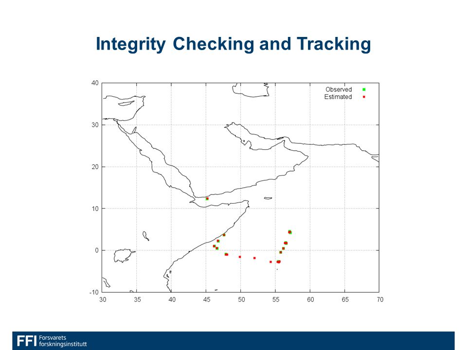
Integrity Checking and Tracking

24
Towards operational implementation

25
FFI’s Mission Control Centre ”Micro-Houston”

26
AISSat-1 MCC

27
Payload operations planning

28
User feedback Primary geographic area Secondary geographic area Desired improvements and development Norwegian Rescue Coordination Centres Norwegian Sea Barents Sea Global -More frequent coverage/shorter update intervals up to continuous real time -Tasking ability Governor of SvalbardSvalbard- -Stability of operations -More frequent coverage/shorter update intervals The Norwegian Fisheries Directorate Barents Sea Norwegian Sea Atlantic -Stability of operations and reduced risk of dropouts -More frequent coverage/shorter update intervals -Increased data collection and analysis from other (Southern Europe, Africa) Norwegian Defence Joint Headquarters Barents Sea Norwegian Sea North Sea Arctic Gulf of Aden Libya USA North East Passage -More frequent coverage/shorter update intervals up to continuous real time -Fused tracks combining AIS and satellite radar
 Norwegian Defence Joint Headquarters Barents Sea Norwegian Sea North Sea Arctic Gulf of Aden Libya USA North East Passage -More frequent coverage/shorter update intervals up to continuous real time -Fused tracks combining AIS and satellite radar")
29
AISSat Status AISSat-1 has been 31 months in orbit Observes approx. 30 000 vessels globally every 24 hours –More than 90 000 unique vessels in total Data supplied to operational users from day 1 Availability (2012): –Satellite: >97% –System: > 95% –MTBF: 24 days –Typical recovery time: 6 hours
: –Satellite: >97% –System: > 95% –MTBF: 24 days –Typical recovery time: 6 hours.")
30
AISSat-1 Orbit Drift and Decay Between: 12.7.2010 and 26.11.2012 Average altitude:

31
AISSat Status Budget :28 MNOK –Development, Build, Launch –Ground Segment (Svalbard, MCC) –Operations AISSat-2:14 MNOK –Build & Launch (mid 2013) –Includes software upgrades for both satellites to: House keeping Computer Payload Data Handling Computer Attitude Control Computer
 –Operations AISSat-2:14 MNOK –Build & Launch (mid 2013) –Includes software upgrades for both satellites to: House keeping Computer Payload Data Handling Computer Attitude Control Computer")
32
NORAIS: Spin-off on the International Space Station

33
NORAIS Norwegian AIS receiver on Columbus/ ISS FFI Kongsberg Seatex N-USOC (Trondheim) ESA NASA Test bed for decoder development 3 upgrades completed Up to double detection performance in “High Traffic Zones” Corresponding upgrade to AISSat-1 is planned April/May
 ESA NASA Test bed for decoder development 3 upgrades completed Up to double detection performance in High Traffic Zones Corresponding upgrade to AISSat-1 is planned April/May")
34
Support to NATO - Ocean Shield

35
Kongsberg Seatex ASR-200 Industrial spin-off

36
Acknowledgements Analyses and reporting were carried out by: Øystein Helleren Øystein Olsen Andreas Nordmo Skauen Torkild Eriksen Bjørn Narheim and The Norwegian Coastal Administration

37
Thanks for listening! Richard.Olsen@ffi.no

Similar presentations


 Mission Phase 0/A Studies Mid-Term Review Meetings January 12-14th, 2011.>")


>")


>")


 Operational Concept Demonstrates Military Operational Utility and Enables Improved Global Weather Prediction Data to Naval.>")