Download presentation
Presentation is loading. Please wait.

1
The Sea Floor

2
Figure 2.01

3
The Ocean Basins Distribution of Oceans: 61% of the Northern Hemisphere is ocean while 80% of the Southern Hemisphere is ocean. Four large basins exist: all are connected allowing seawater, materials and organisms to move from one ocean to another – sometimes called the world ocean. Pacific – deepest and largest ocean Atlantic – larger than Indian, but equal in depth Indian Arctic – smallest and shallowest

4
Figure 2.02 The Southern Ocean refers to the body of water that surrounds Antarctica.

5
Figure 2.03

6
Review of the Structure of the Earth Core – innermost layer, composed mostly of iron. Pressure is 106 times that of the surface. Temperature is over 4000 °Celsius. Swirling motions of the outer core produce earth’s magnetic field. Mantle – layer just beyond the core, thought to be solid and near the melting point of rock. It slowly flows like a liquid. Crust – outermost layer, extremely thin - a rigid skin floating on the mantle

7
Figure 2.04 The land masses on opposite side of the Atlantic have coastlines and geological features that fit together like pieces of a puzzle.

8
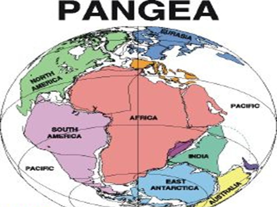
Theory of Plate Tectonics Alfred Wegner, a German geophysicist, first proposed the theory of continental drift in 1912 He suggested that all of the continents had once been joined in a supercontinent called Pangaea. Pangaea began to break up into our current continents about 180 million years ago.

10
Oceanic Crust - (Basalt)Continental Crust - (Granite) Density 3.0 g/ccDensity 2.7 g/cc 5 km thick Geologically young <200 million years old 20 to 50 km thick Can be 3.8 billion years Dark in color Rich in Fe and Mg Light in color Rich in Na, K, Ca and Al
Continental Crust - (Granite) Density 3.0 g/ccDensity 2.7 g/cc 5 km thick Geologically young <200 million years old 20 to 50 km thick Can be 3.8 billion years Dark in color Rich in Fe and Mg Light in color Rich in Na, K, Ca and Al")
11
Figure 2.05 Major features of the sea floor.

12
SEA FLOOR FEATURES Mid-Ocean Ridge – a continuous chain of submarine volcanic mountains that encircle our planet. Sea-floor rock near the ridge is young. Rock gets older as one moves away from center. Bands of magnetic stripes that run parallel to the mid-ocean ridge represent zones in which the rocks on the sea floor alternate between normal and reversed magnetization. Bands are symmetric on either side of ridge. Magnetic anomalies is name given to these stripes. Importance: sea floor must have cooled from molten material at different times.

13
Figure 2.09

14
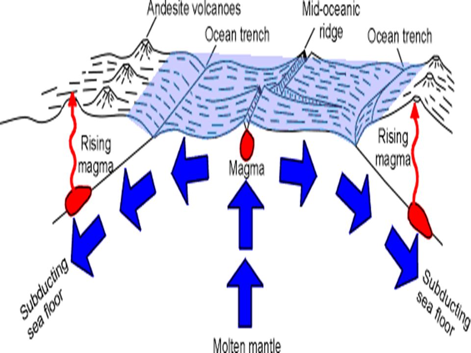
Sea-floor spreading is the name given to the process during which the sea floor moves away from the mid-ocean ridges to create new sea floor. Mid-ocean ridge forms the edges of many tectonic plates 1.It is a continuous chain of submarine volcanic mountains that encircles the globe, the largest geological feature on earth. 2.Mid-Atlantic Ridge runs down the center of the Atlantic Ocean

16
How does sea-floor spreading work? As pieces of oceanic crust separate at the mid-ocean ridges, they create a “rift”. This releases some pressure on the mantle and causes it to melt. The liquid mantle material rises up through the rift. Ascending mantle material pushes up the oceanic crust around the rift to form the mid-ocean ridge. When this molten material reaches the surface, it cools and solidifies to form new oceanic crust.

17
Figure 2.07 Distribution of earthquakes and volcanoes.

18
Figure 2.06

19
Magnetic Reversals 1.Magnetic reversals occur about every 700,000 years 2.It takes about 5000 years for the field to reverse. 3.Cause is thought to be the movement of material in earth’s molten outer core. 4.When rocks cool, the magnetic particles within them align themselves with the current pole. 5.Stripes appear that are symmetrical around the ridge. 6.Called magnetic anomalies – showed that the sea floor cooled at different times

20
Figure 2.08 Normal (dark) and reversed (light) magnetism. stripes form bands running parallel to the mid-ocean ridge.

21
Figure 2.10

22
Figure 2.11 Formation of a trench by the collision of an oceanic and continental plate. Earthquakes are produced as the Nazca Plate descends into the mantle. Lighter material from the plate rises as it melts to create the Andes Mountains.

23
Figure 2.12 Here two oceanic plates meet and form another type of trench. Earthquakes are produced by the descending plate and the volcanoes have produced the Aleutian Islands.

24
Facts about Trenches 1.They are curved because they follow the curvature of the earth. 2. Island arcs (Aleutian and Mariana) which are really volcanic chains also look curved. When two continental plates collide….. Both are light in density and they don’t subduct, but buckle and produce mountain chains, e.g. Himalayas formed when India collided with Asia.
 which are really volcanic chains also look curved. When two continental plates collide….. Both are light in density and they don’t subduct, but buckle and produce mountain chains, e.g. Himalayas formed when India collided with Asia..")
25
Figure 2.13 Mt. Veniaminof, an active volcano on the Alaska Peninsula, part of the Aleutian Island chain that formed from behind the Aleutian Trench.

26
Figure 2.15 Current theory says that plates move mainly because of slab pull, ( old, cold and dense lithosphere sinks into the mantle and pulls the rest of the plate behind it.)
")
27
Traditional theory said that the movement of plates is driven by large scale convection currents in the asthenosphere and lower mantle which are driven in turn by heat from the earth’s core. Even though “slab pull” theory is currently accepted Convection may still play a role in plate motion. http://www.youtube.com/watch?v=p0dWF_3PYh4

28
Figure 2.16

29
Marine Sediments Lithogenous sediment, derived from the physical and chemical breakdown of rocks which are found mostly on continents. Biogenous Sediment, consisting of skeletons and shells of marine organisms. 1. calcareous ooze – sediment composed of CaCO 3 2. siliceous ooze – made of SiO 2 Microfossils are important because they tell us what organisms lived in the ocean in the past and give clues to ocean temperatures. Ocean temperatures are dependent upon the earth’s climate and ocean currents.

30
Figure 2.17 Fossil Shell of a foraminiferan.

31
Climate of the earth 1. Can be determined by C-14 dating 2. Water temperature is found by the ratio of Mg to Ca or of different isotopes of O in microfossils. 3. The ratio of Sr to Ca in coral skeletons records past ocean temperatures. 4. Ice cores from Greenland and Antartica preserve records of past temperatures as well as samples of our ancient atmosphere from tiny air bubbles trapped in the ice.

32
Figure 2.18 History of the earth’s climate over the past half-million years as Determined by foraminiferan microfossils. Red line = average sea surface temps. (Mg to Ca ratios) Blue and white bands = major glacial periods (oxygen isotopes)
 Blue and white bands = major glacial periods (oxygen isotopes).")
33
Figure 2.19

34
Continental Margins -boundaries between continental crust and oceanic crust -sediment from the continents settles to the bottom after reaching the sea and accumulates on the margins -sediment may be 6 miles thick! Continental margins consist of a shallow, gently sloping shelf, a steeper slope and a gently sloping region – the continental rise at the base of the slope. -Varies from 1 km on the Pacific coast of S.A. to 750 km on the Arctic coast of Siberia. - Ends in the “shelf break” where it abruptly gets steeper.

35
Continental Slope - This is the closest thing to the edge of the continent, beginning at the shelf break and descending downward to the deep sea floor. Continental Rise -A thick layer of sediment piled up on the sea floor. - The “deep sea fan” is like a river delta and is caused by sediment moving down a submarine canyon and accumulating at the canyon’s base.

36
Continental Shelf This is the shallowest part of the margin, making up 8% of the ocean’s surface and is the richest part of the ocean! It is composed of the continental crust and is really part of the continent that’s under water. Submarine canyons are canyons formed by the erosion by rivers and glaciers that are now under water.

37
Figure 2.22

38
Active and Passive Margins Active margins are trenches with intense geological activity, such as earthquakes and volcanoes. Characterized by rocky shorelines, narrow continental shelves and steep continental slopes and lacking a well developed continental rise. ( the west coast of N.A.) Passive margins have flat coastal plains, wide shelves and gradual continental slopes. Sediment accumulates at the base of the slope and they have a thick continental rise.
 Passive margins have flat coastal plains, wide shelves and gradual continental slopes. Sediment accumulates at the base of the slope and they have a thick continental rise..")
39
Figure 2.20

40
Figure 2.24

41
Figure 2.23

42
Deep-Ocean Basins The sea floor is almost flat – the abyssal plain. It is dotted with submarine volcanoes called seamounts and volcanic islands. Guyots are flat topped seamounts and are common in the Pacific. The abyssal plain also has plateaus, rises and other features. The Central Rift Valley is the depression at the center of the mid-ocean ridge. It is extremely hot and dotted by hydrothermal vents or deep-sea hot springs.

43
Figure 2.25

44
Hot water dissolves a variety of minerals mostly sulfides. Black Smokers are one type of mineral deposit found at hydrothermal vents – chimney like structures that build up around a vent as minerals solidify.

45
Figure 2.21

46
Figure 2.26

47
Figure 2.27

48
Text Art 2.01

49
Text Art 2.02

50
TABLES

51
Table 2.01

52
Table 2.02

Similar presentations


 Covers 71% of earth’s surface “Divided” into 4 large basins –Pacific (largest, deepest) –Atlantic.>")


 Depth = (time x 1500 m/sec)/2 (round trip) At 25 degrees.>")


>")

