Download presentation
Presentation is loading. Please wait.

1
Department of Geography and Urban Studies, Temple University GUS 0265/0465 Applications in GIS/Geographic Data Analysis Lecture 4: Network Operations

2
Features of a Road Network Link Impedance: weights on an link Turn Impedance: time it takes to complete a turn at a given node Turn Table: table listing turn options and impedance for each node One way or closed streets Overpasses and Underpasses

3
Road Network Operations Address Geocoding Shortest Path Analysis Closest Facility Allocation Location-Allocation

4
Road Network Operations Address Geocoding Takes an address in text form and assigns it a geographic coordinate location

5
Address Geocoding Left_from Left_to Right_from Right_to Street_name Type Left_Zone Right_Zone 201 299 200 298 SUNSET ST 92374 92373 209 Sunset St. 209House number SunsetStreet name St.Type 92374Zone

6
Road Network Operations Shortest Path Analysis Finding the shortest path (in travel cost, not just distance) between two locations on the network. Djikstra’s Algorithm…. http://www.unf.edu/~wkloster/foundations/Dijkst raApplet/DijkstraApplet.htm

7
Shortest Path Analysis Traveling salesman problem: Given a number of stops, find the shortest route that begins at a given location and ends at the same location. http://riot.ieor.berkeley.edu/~cander/cs270/
8
Road Network Operations Closest Facility Finds the closest facility to a given location on a network. Essentially, a multiple shortest path analysis among the given location and each in a set of candidate facilities. The facility with the shortest path is the closest.

9
Road Network Operations Allocation Allocating a region in space to a point facility. For example, allocating urban areas to fire districts based on proximity to the nearest fire station. Each station is allocated a given area.

10
Allocation Shaded area indicates areas within 2 minutes of a fire station

11
Road Network Operations Location-Allocation Finding a location for a point location on a network to maximize some allocation criteria. For example, given the criteria that all areas must be within 2 minutes of a fire station, where should another fire station be built?

12
Road Network Operations

13
Allocation

14
Road Network Operations Location- Allocation

15
Road Network Operations Location-Allocation Minimum distance model – minimizes the total distance traveled from all demand points to their nearest supply centers Maximum covering model – maximizes the demand covered within a specified time or distance

16
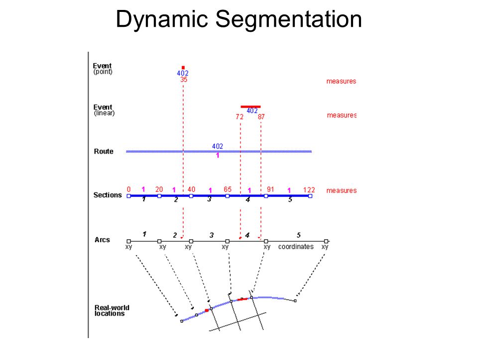
Dynamic Segmentation allows for the representation of routes along a network. was developed to store important network locations that are georeferenced based on their distance along the route from some starting point. For instance, many transportation agencies store geographic information that is georeferenced to mileposts along a highway.

17
Dynamic Segmentation Tables: Route Table: each record is an individual route (a path along the network) with links to individual sections Section Table: each record is an individual section linking a route to its component links Event Table: each record is a ‘thing’ that exists along the route, e.g. a stretch of pavement quality, a bridge location, etc. Arc Attribute Table: each record is an arc (table automatically generated by Arc/Info for vector topologic data structure)
.")
18
Dynamic Segmentation Route table Section table Roads AAT

19
Dynamic Segmentation

Similar presentations
 Operations Research.>")

 Minimum-Cost.>")
 and connecting junctions (points),>")

: A Brief Introduction to Network Analysis Parts of the Network Analysis section of this lecture were borrowed from a UC Berkeley.>")


