Download presentation
Presentation is loading. Please wait.

1
A Review of the NOAA IFEX Hurricane Field Experiments Conducted in 2007 John F. Gamache NOAA/AOML/Hurricane Research Division

2
Discussion Outline HFP Activities Tropical Storm Erin (NHC-tasked reconnaisance; P-3) Hurricane Felix (EMC-tasked 3D Doppler winds; P-3) Tropical Storm Ingrid (EMC-tasked 3D Doppler winds; P-3) Tropical Depression 10 (NESDIS-42, HRD-43; P-3) Hurricane Karen (EMC-tasked 3D Doppler winds; P-3) Hurricane Noel undergoing ET (HRD-tasked P-3; Aerosonde flight) IFEX 2007 Goals
 Hurricane Felix (EMC-tasked 3D Doppler winds; P-3) Tropical Storm Ingrid (EMC-tasked 3D Doppler winds; P-3) Tropical Depression 10 (NESDIS-42, HRD-43; P-3) Hurricane Karen (EMC-tasked 3D Doppler winds; P-3) Hurricane Noel undergoing ET (HRD-tasked P-3; Aerosonde flight) IFEX 2007 Goals")
3
IFEX 2007 Goal 1 Collect observations that span the TC lifecycle in a variety of environments: 3D Doppler Winds (Felix, Ingrid, TD 10, Karen) Goal 2 Develop and refine measurement technologies that provide improved real- time monitoring of TC intensity, structure, and environment (NHC): Aerosonde/P-3 (Noel); 3D Doppler Winds (Felix, Ingrid, TD 10, Karen) Goal 3 Improve our understanding of the physical processes important in intensity change for a TC at all stages of its lifecycle (HRD): Aerosonde/P-3 (Noel)
 Goal 2 Develop and refine measurement technologies that provide improved real- time monitoring of TC intensity, structure, and environment (NHC): Aerosonde/P-3 (Noel); 3D Doppler Winds (Felix, Ingrid, TD 10, Karen) Goal 3 Improve our understanding of the physical processes important in intensity change for a TC at all stages of its lifecycle (HRD): Aerosonde/P-3 (Noel) ")
4
WP-3D Aircraft and their Radars

7
Tropical Storm Erin 070815H1 (Reconnaissance) 070816H1 (Reconnaissance--reached the storm after landfall)
 H1 (Reconnaissance--reached the storm after landfall)")
10
Hurricane Felix 4 Flights flown from St. Croix 070901H1 (Tropical Storm to Minimal Hurricane- -NOAA 42) 070902I1 (Category 2 Hurricane--NOAA 43) 070902H1 (Category 5 Hurricane--NOAA 42) 070903H1 (Category 5 Hurricane--NOAA 43) Observed rapid deepening with Doppler radar every 12 hours, beginning from strong TS to cat 5
 I1 (Category 2 Hurricane--NOAA 43) H1 (Category 5 Hurricane--NOAA 42) H1 (Category 5 Hurricane--NOAA 43) Observed rapid deepening with Doppler radar every 12 hours, beginning from strong TS to cat 5.")
11
070901H1 Combination of flight patterns: 1) Figure 4 pattern 2) Square spiral--spiralling outward 3) Flight centered on 0000 UTC 2 September 2007
 Figure 4 pattern 2) Square spiral--spiralling outward 3) Flight centered on 0000 UTC 2 September 2007")
16
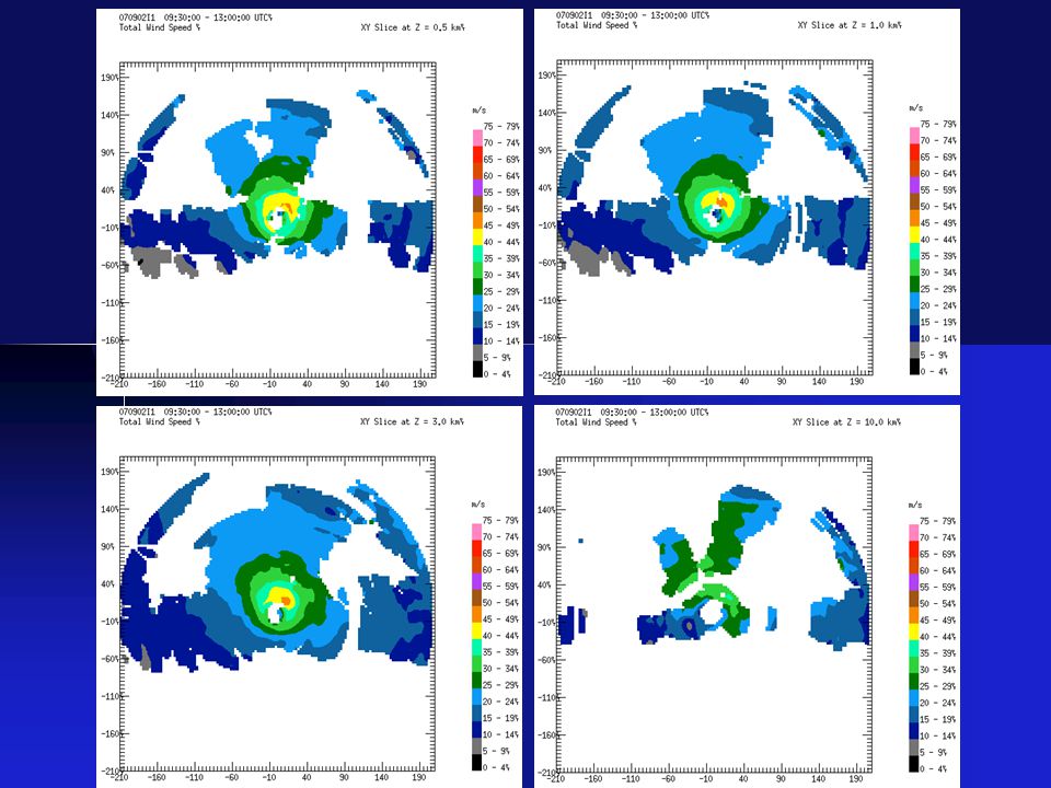
070902I1 Category 2 hurricane flight centered around 12 UTC on 2 September 2007 Truncated “butterfly pattern” due to proximity to Venezuela and Islands north of it

21
070902H1 Figure 4 pattern to be centered around 0 UTC 3 September 2007--truncated due to severe turbulence and protocols concerning G forces Highest value of SFMR surface wind estimate on record

25
070903I1 Figure 4 pattern, centered around 12 UTC 3 September 2007 Hurricane Felix still category 5

30
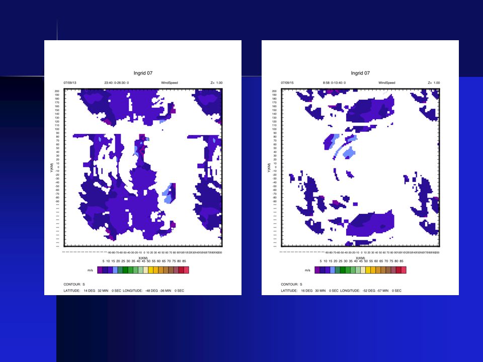
Tropical Storm Ingrid 6 Flights flown from Barbados 070913I1 (3D Doppler Winds--NOAA 43) 070914H1 (3D Doppler Winds--NOAA 42) 070914I1 (3D Doppler Winds--NOAA 43) 070915H1 (3D Doppler Winds--NOAA 42) Approximately 30-hour hiatus 070916I1 (3D Doppler Winds--NOAA 43) 070917H1 (Ocean Winds--NOAA 42) Observed highly sheared tropical storm every 12 hours with airborne Doppler radar
 H1 (3D Doppler Winds--NOAA 42) I1 (3D Doppler Winds--NOAA 43) H1 (3D Doppler Winds--NOAA 42) Approximately 30-hour hiatus I1 (3D Doppler Winds--NOAA 43) H1 (Ocean Winds--NOAA 42) Observed highly sheared tropical storm every 12 hours with airborne Doppler radar")
36
Tropical Depression 10 2 Flights flown from MacDill 070921H1 (Ocean Winds/3D Doppler Winds) 070921I1 (3D Doppler Winds/Landfall)
 I1 (3D Doppler Winds/Landfall)")
37
Hurricane Karen 2 Flights flown from Barbados 070926I1 (3D Doppler Winds--NOAA 43) 070927H1 (3D Doppler Winds--NOAA 42) Observed intensifying minimal hurricane encounter abrupt increase in vertical wind shear
 H1 (3D Doppler Winds--NOAA 42) Observed intensifying minimal hurricane encounter abrupt increase in vertical wind shear")
40
Further automation is needed to start analysis jobs--we will explore complete or near-complete automation during this off-season--improved during 2007 Further automation in determining systematic error corrections for radar pointing angle is needed--accomplished in 2007 Final format of data to be sent still must be agreed upon Faster SATCOM communications will be needed to successfully send enough data to EMC--equipment purchased, very high speed more likely in 2009 Further automation in transmitting files from P3 needed--much improved in 2007, will continue improvement Better pre-season training needed for those operating HRD Doppler QC software aboard the P3--done first time in 2007, more in 2008, eventually including AOC/Non-HRD people Real-time Doppler data Issues

41
Highlights First concerted effort to probe TC-core structure every 12 hours with SMFR and airborne Doppler Coordinated NOAA P3 aircraft with aerosonde

42
IFEX 2008 “Operations” Off-season discussions with TPC, EMC, NESDIS, and AOC concerning tasking and flight tracks Provide Doppler data to EMC after the flight for HWRF assimilation development Supporting Synoptic Surveillance mission planning (HRD) and flying, as needed Limited HRD resources to support a potentially substantial number of operational P3 flight hours Flight testing of G-IV airborne Doppler and software to quality control the new data--will also be good practice for QC of updated Doppler radar on P3s in 2009 “Research” HRD: limited P-3 flight hours devoted to specialized HRD projects Aerosonde, Genesis (weak systems), SALEX, Landfall/Inland decay New DMT cloud physics probes
 and flying, as needed Limited HRD resources to support a potentially substantial number of operational P3 flight hours Flight testing of G-IV airborne Doppler and software to quality control the new data--will also be good practice for QC of updated Doppler radar on P3s in 2009 Research HRD: limited P-3 flight hours devoted to specialized HRD projects Aerosonde, Genesis (weak systems), SALEX, Landfall/Inland decay New DMT cloud physics probes")
43
Particular Thanks go to NOAA Aircraft Operations Center

46
Aerosonde/Noel 071102I1--NOAA 43 Aerosonde/Noel 071102I1--NOAA 43

47
The Aerosonde UAS approached the center of Noel from the north (black), at around 400 m altitude. At the same time, the P-3 (red) was making a penetration from east to west at around 3500 m altitude. GPS dropwindsondes (blue) were deployed at the location where the aircraft met. Noel Aerosonde UAS mission coordinated with NOAA P-3
 was making a penetration from east to west at around 3500 m altitude. GPS dropwindsondes (blue) were deployed at the location where the aircraft met. Noel Aerosonde UAS mission coordinated with NOAA P-3.")
48
Aerosonde P-3 (3500 m) Take-off from Wallops Flight Facility (KWAL) 1600 UTC Rendezvous with P-3 at storm center 0525 UTC KMCF “Eye” loitering with vertical soundings (100- 1500 m)
 Take-off from Wallops Flight Facility (KWAL) 1600 UTC Rendezvous with P-3 at storm center 0525 UTC KMCF Eye loitering with vertical soundings ( m)")
Similar presentations


 Robert Rogers – 2010 HFP Field Program Director 1.>")
 Robert Rogers – 2010 HFP Field Program Director 1.>")
 Shirley Murillo – 2011 HFP Field Program Director 1.>")


 2. Mission summaries a) 100706H1 (Black) b) 100706N (Dunion) c) 100707H1 (Aberson) d) 100707H2 (Black) e) 100707N.>")


 PIs: Dr Sharanya J. Majumdar (University of Miami) Dr Sim D. Aberson (NOAA/AOML/HRD)>")

 Collaborators: Peter Dodge,>")

 Scott Braun (GSFC) Paul Newman.>")

, Stephanie Mullins.>")