Download presentation
Presentation is loading. Please wait.

1
Ministry of Construction and Transportation
Korean NGIS Ministry of Construction and Transportation Seoul, Korea October 2004 Alan R. Stevens, PhD US Federal Geographic Data Committee (FGDC) Global Spatial Data Infrastructure (GSDI) Secretariat US Geological Survey SDI Evolution in the US: Solid technology, policy changes, hard work, & just plain luck
 Global Spatial Data Infrastructure (GSDI) Secretariat. US Geological Survey SDI Evolution in the US: Solid technology, policy changes, hard work, & just plain luck.")
2
US Spatial Data Infrastructure: At the Crossroads & moving forward
US Federal Geographic Data Committee (FGDC) Evolution (nationally) How to keep the pressure on …? How to percolate it down to the working level? Gospatial One-Stop (e-gov) Future Directions
 Evolution (nationally) How to keep the pressure on … How to percolate it down to the working level Gospatial One-Stop (e-gov) Future Directions.")
3
US Spatial Data Infrastructure:
Caveat……. One model does not fit all What works in the US is not magic … but there are things to be learned from the model

4
The Big Question……..?? So exactly what is:
The US Federal Geographic Data Committee (FGDC), The National Spatial Data Infrastructure (NSDI), and How does it all fit together?
, The National Spatial Data Infrastructure (NSDI), and. How does it all fit together")
5
What is a National Spatial Data Infrastructure (NSDI) ………?
To encourage the collection, processing, archiving, integration, and sharing of geospatial data and information using common standards and interoperable systems and techniques ….. and accessible via the web · Expand…. – Brings information together in new ways – the ability to integrate various layers of data from multiple sources & visualize the data into one or more comprehensive views. · Enhance…. – Look at multiple possible solutions – improves ones ability to understand various options, visualize/analyze key relationships among the data, and explore implications of decisions/tradeoffs. It enables analysis that would otherwise not be done. · Streamline…. – Helps affected managers and stakeholders readily understand key issues – having a better understanding of the options enables one to take more informed steps in the process and as a result facilitates (in many cases shortens) the process of building consensus. · Dramatically…. - comprehensive views of data + better analysis of options + reaching consensus more effectively = a more informed decision.
 the process of building consensus. · Dramatically…. - comprehensive views of data + better analysis of options + reaching consensus more effectively = a more informed decision.")
6
Core Components of the NSDI
Clearinghouse (catalog) Metadata Standards Framework GEOdata The FGDC identified some basic components of the US NSDI, they are Standards; geographic data; Metadata; Clearinghouses, and partnerships. I’ll cover our progress with each of these components now. Partnerships
 Metadata. Standards. Framework. GEOdata. The FGDC identified some basic components of the US NSDI, they are Standards; geographic data; Metadata; Clearinghouses, and partnerships. I’ll cover our progress with each of these components now. Partnerships.")
7
The Federal Geographic Data Committee …. What is it??
Formed about 1990 to promote the development and implementation of the National Spatial Data Infrastructure (NSDI) · Expand…. – Brings information together in new ways – the ability to integrate various layers of data from multiple sources & visualize the data into one or more comprehensive views. · Enhance…. – Look at multiple possible solutions – improves ones ability to understand various options, visualize/analyze key relationships among the data, and explore implications of decisions/tradeoffs. It enables analysis that would otherwise not be done. · Streamline…. – Helps affected managers and stakeholders readily understand key issues – having a better understanding of the options enables one to take more informed steps in the process and as a result facilitates (in many cases shortens) the process of building consensus. · Dramatically…. - comprehensive views of data + better analysis of options + reaching consensus more effectively = a more informed decision.
 · Expand…. – Brings information together in new ways – the ability to integrate various layers of data from multiple sources & visualize the data into one or more comprehensive views. · Enhance…. – Look at multiple possible solutions – improves ones ability to understand various options, visualize/analyze key relationships among the data, and explore implications of decisions/tradeoffs. It enables analysis that would otherwise not be done. · Streamline…. – Helps affected managers and stakeholders readily understand key issues – having a better understanding of the options enables one to take more informed steps in the process and as a result facilitates (in many cases shortens) the process of building consensus. · Dramatically…. - comprehensive views of data + better analysis of options + reaching consensus more effectively = a more informed decision.")
8
The Federal Geographic Data Committee …. What is it??
It is really two things: A staff of about 26 people supporting the Secretary of the Interior A committee of 19 Cabinet Level Offices promulgating the NSDI · Expand…. – Brings information together in new ways – the ability to integrate various layers of data from multiple sources & visualize the data into one or more comprehensive views. · Enhance…. – Look at multiple possible solutions – improves ones ability to understand various options, visualize/analyze key relationships among the data, and explore implications of decisions/tradeoffs. It enables analysis that would otherwise not be done. · Streamline…. – Helps affected managers and stakeholders readily understand key issues – having a better understanding of the options enables one to take more informed steps in the process and as a result facilitates (in many cases shortens) the process of building consensus. · Dramatically…. - comprehensive views of data + better analysis of options + reaching consensus more effectively = a more informed decision.
 the process of building consensus. · Dramatically…. - comprehensive views of data + better analysis of options + reaching consensus more effectively = a more informed decision.")
9
What does the FGDC do……? It builds alliances to:
Address institutional barriers Identify and develop policy changes Identify most effective ways to collect, maintain and distribute data Designate data stewards Reach consensus on framework · Expand…. – Brings information together in new ways – the ability to integrate various layers of data from multiple sources & visualize the data into one or more comprehensive views. · Enhance…. – Look at multiple possible solutions – improves ones ability to understand various options, visualize/analyze key relationships among the data, and explore implications of decisions/tradeoffs. It enables analysis that would otherwise not be done. · Streamline…. – Helps affected managers and stakeholders readily understand key issues – having a better understanding of the options enables one to take more informed steps in the process and as a result facilitates (in many cases shortens) the process of building consensus. · Dramatically…. - comprehensive views of data + better analysis of options + reaching consensus more effectively = a more informed decision.
 the process of building consensus. · Dramatically…. - comprehensive views of data + better analysis of options + reaching consensus more effectively = a more informed decision.")
10
What does the FGDC do……? It builds alliances to:
Encourage metadata creation Clearinghouse development Encourage the use common standards and participation in national and international standards committees Seek new partners Develop incentives for participants Etc……. · Expand…. – Brings information together in new ways – the ability to integrate various layers of data from multiple sources & visualize the data into one or more comprehensive views. · Enhance…. – Look at multiple possible solutions – improves ones ability to understand various options, visualize/analyze key relationships among the data, and explore implications of decisions/tradeoffs. It enables analysis that would otherwise not be done. · Streamline…. – Helps affected managers and stakeholders readily understand key issues – having a better understanding of the options enables one to take more informed steps in the process and as a result facilitates (in many cases shortens) the process of building consensus. · Dramatically…. - comprehensive views of data + better analysis of options + reaching consensus more effectively = a more informed decision.
 the process of building consensus. · Dramatically…. - comprehensive views of data + better analysis of options + reaching consensus more effectively = a more informed decision.")
11
FEDERAL GEOGRAPHIC DATA COMMITTEE (FGDC): Early Going
Slow to start Obtain High level involvement Administratively assigned to the USGS National Mapping Division Represents the Secretary of the Interior Sell, sell, sell Early goal …. to get buy-in

12
The Federal Geographic Data Committee
Chartered in the early 1990s Federal – 19 cabinet level agencies & offices Many states, regional, & local governments participate Along with the private sector, NGOs, and Academia · Expand…. – Brings information together in new ways – the ability to integrate various layers of data from multiple sources & visualize the data into one or more comprehensive views. · Enhance…. – Look at multiple possible solutions – improves ones ability to understand various options, visualize/analyze key relationships among the data, and explore implications of decisions/tradeoffs. It enables analysis that would otherwise not be done. · Streamline…. – Helps affected managers and stakeholders readily understand key issues – having a better understanding of the options enables one to take more informed steps in the process and as a result facilitates (in many cases shortens) the process of building consensus. · Dramatically…. - comprehensive views of data + better analysis of options + reaching consensus more effectively = a more informed decision.
 the process of building consensus. · Dramatically…. - comprehensive views of data + better analysis of options + reaching consensus more effectively = a more informed decision.")
13
A FEDERAL GEOGRAPHIC DATA COMMITTEE (FGDC): Good fortune
OMB Circular A-16 already in place National Spatial Data Infrastructure formed by Presidential Executive Order 12906 ‘…coordinating geographic data acquisition and access….’ 2000 – Stronger emphasis built into the A-16 circular

14
A FEDERAL GEOGRAPHIC DATA COMMITTEE (FGDC): Good fortune ……..
1992 – Administrations focus on streamlining government Vice President tasked Cost/benefits associated with and NSDI Secretary of Interior directly involved Raised awareness and participation of all other cabinet offices Eight years of close attention

15
Federal Geographic Data Committee (FGDC)
Organisation and Operation

16
What’s the budget …….? Annually, about $4.9M USD
About $2.3M USD for salary About $2.6 M USD discretionary CAP Grants …… $1.0 – $1.5M Standards Framework Clearinghouse/portal Partnerships Geospatial One-Stop International ……… etc.

17
FGDC Steering Committee Cabinet Officers and Agencies:
Interior (Vice Chair) Agriculture Defense Energy HHS HUD Justice State Transportation EPA Emergency Mgt Library of Congress NASA Archives OMB (Vice Chair) Commerce NSF TVA GSA
 Agriculture. Defense. Energy. HHS. HUD. Justice. State. Transportation. EPA. Emergency Mgt. Library of Congress. NASA. Archives. OMB (Vice Chair) Commerce. NSF. TVA. GSA.")
18
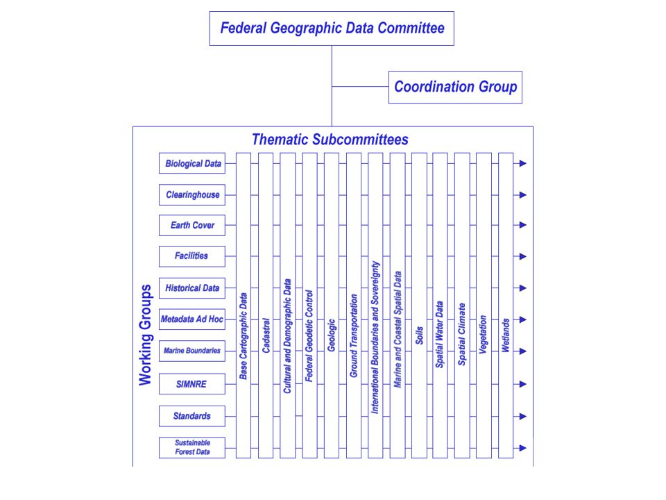
FGDC Working Groups (8) Metadata Clearinghouse Standards
Historical Data Biological Data Facilities Sustainable Forest Data Earth Cover

19
FGDC Thematic Subcommittees(13)
Base Cartographic Data Cadastral Cultural and Demographic Data Federal Geodetic Control Geologic Ground Transportation International Boundaries Soils Spatial Climate Spatial Water Data Vegetation Wetlands Marine Coastal

21
FGDC Staff Support Staff Director (Ivan Deloatch)
Deputy Staff Director (0) Geospatial One-Stop (6+) Framework & Cooperating Groups (1) Standards (1+) Metadata (1+) Clearinghouse (1)
 Geospatial One-Stop (6+) Framework & Cooperating Groups (1) Standards (1+) Metadata (1+) Clearinghouse (1)")
22
FGDC Staff Support International Program (3.0) Education & Training
Grant Programs (1) FGDC Secretariat Support (1) Administration and Finance (1) Staff Assistants (2) Systems and Network (2) Communications (1)
 FGDC Secretariat Support (1) Administration and Finance (1) Staff Assistants (2) Systems and Network (2) Communications (1)")
23
NSDI In the United States Strong high-level political federal support
FGDC starts 1990 High level political support OMB Circular A-16 NSDI Presidential Executive Order 1994 Secretarial involvement in the FGDC Extensive partnerships established Standards -- nationally, internationally Clearinghouse network Open policy for federal spatial data

24
Federal Geographic Data Steering Committee
It’s not just federal……. States Counties Municipalities Non-Governmental Organisations Industry But ………..

25
The Federal Geographic Data Committee …. what’s new?
Major focus within the Federal Government An effort to reach into states and communities Need a sustained effort to drive the concept and application to the states and local governments UTILITIES ……. · Expand…. – Brings information together in new ways – the ability to integrate various layers of data from multiple sources & visualize the data into one or more comprehensive views. · Enhance…. – Look at multiple possible solutions – improves ones ability to understand various options, visualize/analyze key relationships among the data, and explore implications of decisions/tradeoffs. It enables analysis that would otherwise not be done. · Streamline…. – Helps affected managers and stakeholders readily understand key issues – having a better understanding of the options enables one to take more informed steps in the process and as a result facilitates (in many cases shortens) the process of building consensus. · Dramatically…. - comprehensive views of data + better analysis of options + reaching consensus more effectively = a more informed decision.
 the process of building consensus. · Dramatically…. - comprehensive views of data + better analysis of options + reaching consensus more effectively = a more informed decision.")
26
The Federal Geographic Data Committee …. what’s new?
Geospatial One-Stop E-gov E-com NSDI Future Directions · Expand…. – Brings information together in new ways – the ability to integrate various layers of data from multiple sources & visualize the data into one or more comprehensive views. · Enhance…. – Look at multiple possible solutions – improves ones ability to understand various options, visualize/analyze key relationships among the data, and explore implications of decisions/tradeoffs. It enables analysis that would otherwise not be done. · Streamline…. – Helps affected managers and stakeholders readily understand key issues – having a better understanding of the options enables one to take more informed steps in the process and as a result facilitates (in many cases shortens) the process of building consensus. · Dramatically…. - comprehensive views of data + better analysis of options + reaching consensus more effectively = a more informed decision.
 the process of building consensus. · Dramatically…. - comprehensive views of data + better analysis of options + reaching consensus more effectively = a more informed decision.")
27
What is the President’s management agenda?
…… pathway to a government that delivers results…. Making it … easier, faster, cheaper…. for all levels of government and public to access geospatial data and information - With today’s emphasis on digital spatial data, new products are created with greater frequency. There continues to be, however, some institutional resistance to putting data into a form such that it can be widely used. With this increased production comes the potential for substantial duplication of effort, as virtually identical digital products appear from different agencies to satisfy their often very specific needs. - The costs of creating and maintaining digital spatial data are high, so it is particularly important that data created at considerable cost and effort be collected to standards and shareable to ensure that the collected data be fully utilized to realize all of its potential benefits.

28
What is the President’s management agenda?
E-Government ….. Use of digital technology to transform government operations to improve efficiency and effectiveness It is a means to an end; not an ‘end’ in itself………. - With today’s emphasis on digital spatial data, new products are created with greater frequency. There continues to be, however, some institutional resistance to putting data into a form such that it can be widely used. With this increased production comes the potential for substantial duplication of effort, as virtually identical digital products appear from different agencies to satisfy their often very specific needs. - The costs of creating and maintaining digital spatial data are high, so it is particularly important that data created at considerable cost and effort be collected to standards and shareable to ensure that the collected data be fully utilized to realize all of its potential benefits.

29
What is Geospatial One-Stop?
Goal ….. Provide federal and state agencies with a single point of access to geographic information reducing/eliminating redundant data collection and archives. Milestones ….. Identify federal inventory of framework data Focus on standards Deploy Geospatial 1-stop portal - With today’s emphasis on digital spatial data, new products are created with greater frequency. There continues to be, however, some institutional resistance to putting data into a form such that it can be widely used. With this increased production comes the potential for substantial duplication of effort, as virtually identical digital products appear from different agencies to satisfy their often very specific needs. - The costs of creating and maintaining digital spatial data are high, so it is particularly important that data created at considerable cost and effort be collected to standards and shareable to ensure that the collected data be fully utilized to realize all of its potential benefits.

30
So how does does all of this relate to the NSDI???
One and the same……… Another way to promote and drive some of the basic cannons of the NSDI Really a mechanism to: keep the pressure on ……. To keep the principles of the program in front of the NSDI advocates and the user community To percolate the concepts to the lowest levels

31
The Federal Geographic Data Committee …. what’s new?
Geospatial One-Stop E-gov E-com NSDI Future Directions · Expand…. – Brings information together in new ways – the ability to integrate various layers of data from multiple sources & visualize the data into one or more comprehensive views. · Enhance…. – Look at multiple possible solutions – improves ones ability to understand various options, visualize/analyze key relationships among the data, and explore implications of decisions/tradeoffs. It enables analysis that would otherwise not be done. · Streamline…. – Helps affected managers and stakeholders readily understand key issues – having a better understanding of the options enables one to take more informed steps in the process and as a result facilitates (in many cases shortens) the process of building consensus. · Dramatically…. - comprehensive views of data + better analysis of options + reaching consensus more effectively = a more informed decision.
 the process of building consensus. · Dramatically…. - comprehensive views of data + better analysis of options + reaching consensus more effectively = a more informed decision.")
32
FGDC/NSDI Future Directions
Why do we need to …….? Added one-stop 1994 & 97 strategic plans developed New staff director Really need the local data holdings to adopt Questions about the coordination of NSDI, GOS, and CTM Attention to Homeland Security

33
FGDC/NSDI Future Directions
…and so, to the question Where do we want to be in 2014?

34
FGDC/NSDI Future Directions
What is the process????? FGDC staff built straw-man Involve other stakeholders Consumed the entire FGDC coordination committee

35
FGDC/NSDI Future Directions
VISION: Current and accurate geospatial data will be available to contribute locally, nationally, and globally to economic growth, environmental quality, and stability, and social progress

36
FGDC/NSDI Future Directions
1. Forging partnerships with a purpose Expand the governance model

37
The Federal Geographic Data Committee …. what’s new?
Major focus within the Federal Government An effort to reach into states and communities Need a sustained effort to drive the concept and application to the states and local governments UTILITIES ……. · Expand…. – Brings information together in new ways – the ability to integrate various layers of data from multiple sources & visualize the data into one or more comprehensive views. · Enhance…. – Look at multiple possible solutions – improves ones ability to understand various options, visualize/analyze key relationships among the data, and explore implications of decisions/tradeoffs. It enables analysis that would otherwise not be done. · Streamline…. – Helps affected managers and stakeholders readily understand key issues – having a better understanding of the options enables one to take more informed steps in the process and as a result facilitates (in many cases shortens) the process of building consensus. · Dramatically…. - comprehensive views of data + better analysis of options + reaching consensus more effectively = a more informed decision.
 the process of building consensus. · Dramatically…. - comprehensive views of data + better analysis of options + reaching consensus more effectively = a more informed decision.")
38
FGDC/NSDI Future Directions
2. Making framework real …generating framework data themes that will include collection, documentation, access, and utilization of data.

39
FGDC/NSDI Future Directions
3. Communicating the Message …recognized across the nation as the primary source for the availability and use of reliable spatial data

40
Create a National Spatial Data Infrastructure (NSDI) ………
To encourage the collection, processing, archiving, integration, and sharing of geospatial data and information using common standards and interoperable systems and techniques ….. and accessible via the web

41
Genesis of the US National Spatial Data Infrastructure
FGDC formed 1994 NSDI formed by Presidential Executive Order 12906 International awareness 1999 Implementation Teams started 2001 OMB Circular A-16 updated 2002 Geospatial One-Stop Outside of the US, similar SDI initiatives were being implemented and planned in other nations and regions of the world. Additionally, the concept of a Global Spatial Data Infrastructure was formalized with the first international gathering of interested nations in Germany, 1996. In 1998, an extensive NAPA Study of Geographic Information in the 21st Century was issued, with over 50 recommendations for furthering the NSDI

42
Create a Global Spatial Data Infrastructure (GSDI) ………
To encourage the collection, processing, archiving, integrating, and sharing of geospatial data and information using common standards and interoperable systems and techniques ….. and accessible via the web · Expand…. – Brings information together in new ways – the ability to integrate various layers of data from multiple sources & visualize the data into one or more comprehensive views. · Enhance…. – Look at multiple possible solutions – improves ones ability to understand various options, visualize/analyze key relationships among the data, and explore implications of decisions/tradeoffs. It enables analysis that would otherwise not be done. · Streamline…. – Helps affected managers and stakeholders readily understand key issues – having a better understanding of the options enables one to take more informed steps in the process and as a result facilitates (in many cases shortens) the process of building consensus. · Dramatically…. - comprehensive views of data + better analysis of options + reaching consensus more effectively = a more informed decision.
 the process of building consensus. · Dramatically…. - comprehensive views of data + better analysis of options + reaching consensus more effectively = a more informed decision.")
43
Global Spatial Data Infrastructure
GSDI conferences GSDI 1 Bonn Germany Sept 1995 GSDI 2 Chapel Hill NC October 1997 GSDI 3 Canberra Australia November 1998 GSDI 4 Capetown South Africa March 2000 GSDI 5 Cartagena Colombia May 2001 GSDI 6 Budapest Hungary September 2002 GSDI 7 Bangalore India February 2004 GSDI 8 Cairo (with FIG) April 2005
 April")
45
Creating the GSDI Association
Incorporated in Virginia in June 2002 Board of Directors operating since September 2002 Past, present and incoming Presidents, chairs of technical and Legal and Economic Working Groups and secretariat Bylaws agreed by Steering Committee/ Council in January 2003 Fully operational by GSDI 7 in 2004

46
GSDI Secretariat Progress 2003
Permanent Committees for: Asia & the Pacific (PCGIAP) Americas (PCIDEA) Europe (EUROGI) Africa (CODI and partners) KISM, UNECA, CODI, EIS Africa
 Americas (PCIDEA) Europe (EUROGI) Africa (CODI and partners) KISM, UNECA, CODI, EIS Africa.")
47
GSDI – An idea at the cusp Vision……….
Foster SDI development locally to globally Access data at a variety of scales and from multiple sources Common standards an interoperable systems and techniques Heavy reliance on partners world-wide

48
GSDI – An idea at the cusp Goals……….
Promote and develop awareness and exchanges Facilitate data access/discovery via clearinghouse, portal web services Stimulate & conduct capacity building Conduct and sponsor SDI development research Engage partners to help

49
FGDC & GSDI Secretariat Success stories………
Cookbook: Doug Nebert; Editor in Chief It contains contributions from many nations FGDC/GSDI will maintain it and make it available on the GSDI website It is a living document

50
Editor: Douglas D. Nebert, Technical Working Group Chair, GSDI
Developing Spatial Data Infrastructures: The SDI Cookbook Version 1.0 6 July 2000 Release for Review at the Fourth Global Spatial Data Infrastructure Conference, Cape Town, South Africa Disclaimer: This draft represents a work-in-progress that has been compiled from numerous contributions and available online documents contributing organisations. Full acknowledgement of contributions and citations will be provided in the initial public draft. Editor: Douglas D. Nebert, Technical Working Group Chair, GSDI Document Available At:

51
Cookbook Objectives Define a reference environment for building compatible spatial data infrastructures for use by all communities Promote best practices, technologies, and guidance for their implementation in a changing Internet environment with low-cost reference implementations, wherever possible Create an online resource and information web for dissemination

52
Cookbook Design Concept
Chapter Meta data Online Mapping Integrating Services Case Studies Data Catalog Access Outreach Terms Context and Rationale Organisational Approach Implementation Approach

53
Chapter Review Each chapter has a lead individual to build content with others Where possible have progression of context, through abstract model, to implementation Conclude with Recommendations Include hyperlinks and external references Have just released Version 2.0 for the GSDI-7 conference

54
Version 2.0 Version 2.0 (English) has two new chapters:
“Other Services” describing geospatial service interfaces and chaining “Terminology” including how one can standardise terminology and includes a glossary of the document Updated reference to all current work: existing standards and specifications

55
Chapter Seven: Other Services
Additional related services are to be described here, e.g. coordinate transform Standards: OpenGIS Services (CTS, Service Chaining) Lead: Nadine Alameh, GST
 Lead: Nadine Alameh, GST.")
56
Ingredients for success
The FGDC has lived and prospered through 3 different political administrations ……. Why? Maintained high level policy awareness Always promotes better governance Keep the pressure on

57
Additional Information
Federal Geographic Data Committee Global Spatial Data Infrastructure Permanent Comm. for Geog. Info. for Asia and the Pacific Perm. Comm. For the Americas European Umbrella Org. for Geog. Open GIS Consortium

60
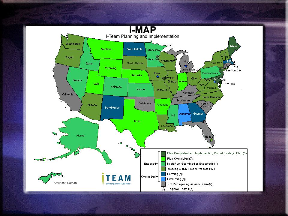
WHAT IS AN I-TEAM ? In the US, it is a collaborative process for a state to organize the way it produces, archives, and shares its digital geospatial assets ….. a State SDI · Expand…. – Brings information together in new ways – the ability to integrate various layers of data from multiple sources & visualize the data into one or more comprehensive views. · Enhance…. – Look at multiple possible solutions – improves ones ability to understand various options, visualize/analyze key relationships among the data, and explore implications of decisions/tradeoffs. It enables analysis that would otherwise not be done. · Streamline…. – Helps affected managers and stakeholders readily understand key issues – having a better understanding of the options enables one to take more informed steps in the process and as a result facilitates (in many cases shortens) the process of building consensus. · Dramatically…. - comprehensive views of data + better analysis of options + reaching consensus more effectively = a more informed decision.
 the process of building consensus. · Dramatically…. - comprehensive views of data + better analysis of options + reaching consensus more effectively = a more informed decision.")
61
Why do we want I-Teams ? Helps all levels of government fulfill their missions Develops links between: The US FGDC and the State and its data The State and the County/City data Supports and facilitates: The US NSDI in concept and operation Geospatial One Stop GSDI ……. local to global · Expand…. – Brings information together in new ways – the ability to integrate various layers of data from multiple sources & visualize the data into one or more comprehensive views. · Enhance…. – Look at multiple possible solutions – improves ones ability to understand various options, visualize/analyze key relationships among the data, and explore implications of decisions/tradeoffs. It enables analysis that would otherwise not be done. · Streamline…. – Helps affected managers and stakeholders readily understand key issues – having a better understanding of the options enables one to take more informed steps in the process and as a result facilitates (in many cases shortens) the process of building consensus. · Dramatically…. - comprehensive views of data + better analysis of options + reaching consensus more effectively = a more informed decision.
 the process of building consensus. · Dramatically…. - comprehensive views of data + better analysis of options + reaching consensus more effectively = a more informed decision.")
62
What is it not?? It is not a new agency It is not more bureaucracy
Probably not looking for more money Although ………………???? Not separate from NSDI or FGDC!! · Expand…. – Brings information together in new ways – the ability to integrate various layers of data from multiple sources & visualize the data into one or more comprehensive views. · Enhance…. – Look at multiple possible solutions – improves ones ability to understand various options, visualize/analyze key relationships among the data, and explore implications of decisions/tradeoffs. It enables analysis that would otherwise not be done. · Streamline…. – Helps affected managers and stakeholders readily understand key issues – having a better understanding of the options enables one to take more informed steps in the process and as a result facilitates (in many cases shortens) the process of building consensus. · Dramatically…. - comprehensive views of data + better analysis of options + reaching consensus more effectively = a more informed decision.
 the process of building consensus. · Dramatically…. - comprehensive views of data + better analysis of options + reaching consensus more effectively = a more informed decision.")
63
What Do I-Teams Do? Address institutional barriers
Identify most effective ways to collect, maintain and distribute data Designate data stewards As best we can to fit into NSDI recommendations including: Metadata creation Clearinghouse development Framework etc · Expand…. – Brings information together in new ways – the ability to integrate various layers of data from multiple sources & visualize the data into one or more comprehensive views. · Enhance…. – Look at multiple possible solutions – improves ones ability to understand various options, visualize/analyze key relationships among the data, and explore implications of decisions/tradeoffs. It enables analysis that would otherwise not be done. · Streamline…. – Helps affected managers and stakeholders readily understand key issues – having a better understanding of the options enables one to take more informed steps in the process and as a result facilitates (in many cases shortens) the process of building consensus. · Dramatically…. - comprehensive views of data + better analysis of options + reaching consensus more effectively = a more informed decision.
 the process of building consensus. · Dramatically…. - comprehensive views of data + better analysis of options + reaching consensus more effectively = a more informed decision.")
64
What Do I-Teams Do? Develop Enterprise Plans (I-Plans) for data production and publication by the most appropriate partner(s) at accuracy and scale(s) needed by local - state jurisdictions
 for data production and publication by the most appropriate partner(s) at accuracy and scale(s) needed by local - state jurisdictions.")
66
The Federal Geographic Data Committee …. what’s new?
Implementation Teams (I-Teams) Geospatial One-Stop E-gov E-com · Expand…. – Brings information together in new ways – the ability to integrate various layers of data from multiple sources & visualize the data into one or more comprehensive views. · Enhance…. – Look at multiple possible solutions – improves ones ability to understand various options, visualize/analyze key relationships among the data, and explore implications of decisions/tradeoffs. It enables analysis that would otherwise not be done. · Streamline…. – Helps affected managers and stakeholders readily understand key issues – having a better understanding of the options enables one to take more informed steps in the process and as a result facilitates (in many cases shortens) the process of building consensus. · Dramatically…. - comprehensive views of data + better analysis of options + reaching consensus more effectively = a more informed decision.
 Geospatial One-Stop. E-gov. E-com. · Expand…. – Brings information together in new ways – the ability to integrate various layers of data from multiple sources & visualize the data into one or more comprehensive views. · Enhance…. – Look at multiple possible solutions – improves ones ability to understand various options, visualize/analyze key relationships among the data, and explore implications of decisions/tradeoffs. It enables analysis that would otherwise not be done. · Streamline…. – Helps affected managers and stakeholders readily understand key issues – having a better understanding of the options enables one to take more informed steps in the process and as a result facilitates (in many cases shortens) the process of building consensus. · Dramatically…. - comprehensive views of data + better analysis of options + reaching consensus more effectively = a more informed decision.")
Similar presentations


 Circular A-16 Supplemental Guidance, is the coordination of Federal geospatial.>")


>")

 ASPRS Spring Meeting Denver, Colorado Alan R. Stevens International Program Coordinator, FGDC Global Spatial.>")


