Download presentation
Presentation is loading. Please wait.

1
Dr. R. Sivasamy Professor and Head Remote Sensing and Geographic Information System Department, Tamil Nadu Agricultural University, India siva_tnau@yahoo.com rsgis@tnau.ac.in

2
Coverage Introduction of RS & GIS in Research and Curriculum Agro-meteorological Advisory Agri-tech Portal Market Intelligence RS & GIS Applications in Agriculture Soil resource Inventory Land Degradation Mapping & Soil Erosion Modeling Spectral Library Precision Farming Soil Information System Crop Planner

3
Introduction of RS & GIS RS Applications in Agriculture – a Unit in SS&AC Dept. started in 1989 Soil Scientists trained in National and International Institutions Used visual products for mapping Soil Resources Delineated gypsum mined areas, water logged areas Modeled soil erosion by water Carried out varietal discrimination, biomass and yield estimation in field crops Generated DTM of micro-watershed

4
Introduction of RS & GIS Department of RS & GIS from April 2010 Multi-disciplinary team of scientists Offers RS & GIS Courses for UG & PG Programmes Generates Soil Resource Database RI-SAT Data Application in Soil Moisture Monitoring HRD-Training on RS & GIS Applications in Agri. Research on Drought Monitoring using MODIS data Hyperspectral Studies Started PG Program in M.Tech.(Ag.) in Geo- informatics in 2013
 in Geo- informatics in")
5
Agro-meteorological Advisory Agro-Climatic Research Centre makes Medium Range Weather Forecasts Offers Farm Advisory on Agricultural Operations Conducts Climate Change related studies on Crop Growth using Crop Growth Models and Open Top Growth Chambers Established AWSs in all Block and collects hourly data on weather parameters and use in downsizing weather forecasts

6
Agri-tech Portal An Agritech portal with five lakh and more pages is built and maintained by eExtension Unit Received ‘Best e-Governance Award’ for the year 2011-12 The portal provides technologies for crop production, animal husbandry Hosts success stories of farmers and farmers’ innovations Information on Government schemes, credit facilities and special technologies for entrepreneurs The portal is updated on daily basis and visited by thousands of farmers, technologists, administrators and extension personnel every day The e-Extension Centre has multiple video conferencing facility and connects to all the TNAU College campuses, Agricultural Development Centres

7
Market Intelligence Domestic and Export Market Intelligence Cell offers advisory services on marketing Registered farmers receive prevailing prices in different local and export markets for the produces/products of their interest Forecasts price for agricultural produce and value added products Collects Cost of Cultivation of Principle Crops Maintains a database on price of agricultural commodities from the leading markets of Tamil Nadu and neighbouring States

8
RS & GIS Applications in Agriculture SOIL RESOURCE INVENTORY Visual interpretation of FCC from TM & LISS and PAN sharpened LISS3 data Digital classification of LISS3 data and integration of Physiography, Results of Terrain Analysis of DEM Selection of sample strips and profile examination and laboratory analysis Digital Soil Database for Tamil Nadu in NRIS of ISRO Land Evaluation and Management Options and Crop Selection

9
RS & GIS Applications in Agriculture LAND DEGRADATION MAPPING Digital classification ofMulti-temporal LISS3 data for 2005- 2006 Integration of Land Use Land Cover maps and results from Terrain analysis Mapping Land Degradation Process and Degree Selection of sample strips and profile examination and laboratory analysis Management Options and Conservation Measures Land Degradation Map of Tamil Nadu in NRIS

10
RS & GIS Applications in Agriculture SPECTRAL LIBRARY Spectro-radiometer in 350 t0 1050 nm range is used Crops and Varieties under different Nutrient Management and Crop Geometry Crop Damage by Pests and Diseases Soil Degradation due to erosion and pollutants Soil Mineralogical studies

11
Towards Precision Farming Spatial Variability Analysis

12
Spatial Variability and Management Zoning Field No. N kg/ha SDFarm12011.5 1132.53.8 2134.52.5 3114.29.3 4107.84.8 5113.68.1 6113.16.3 7127.94.0

13
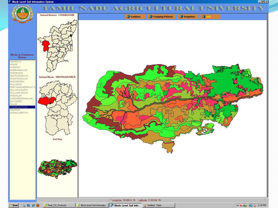
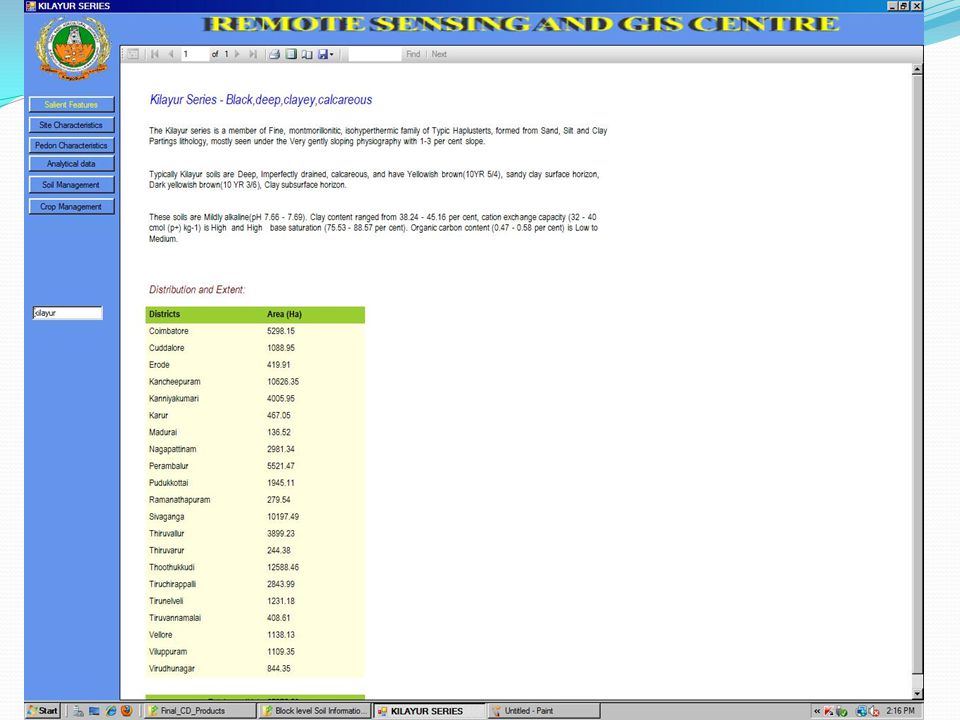
Soil Information System

19
Crop Planner for Cauvery Delta

23
Farm Level Management System

24
Thank you very much

Similar presentations


 for mapping drought stress at regional scale D. Buffet, R. Oger Walloon.>")


 2015-16 Projection APYAPYAPYAPY Rice 19.0474.59391817.2671.15412218.0075.62420021.0093.004429.>")


 Extension management Watershed management Market led extension Gender sensitization Training methodology.>")
>")