Download presentation
Presentation is loading. Please wait.

1
Celestial Coordinate Systems K-12 Coordinate Curriculum
Karen Lancour Chandra Resource Agent and Mark Van Hecke K-12 Celestial and Terrestrial Coordinate curriculum Developed by Karen Lancour and Mark VanHecke - Chandra Resource Agents Curriculum is designed to align with National Standards Interdisciplinary – Science, Geography, Math, Language Arts, Problem Solving

2
Night Sky Sky appears as inside of a very large sphere
88 constellations Important to specify positions of objects in the sky in relation to one another Coordinate systems Sky appears as inside of a very large sphere. Human eye can see 6000 stars unaided. Sky is divided into 88 regions called constellations. Stars appear to rotate around the earth but earth is actually rotating once a day – diurnal motion. It is important to specify positions of objects in the sky in relation to one another.

3
Appearance of the Night Sky
3-dimensional space appears as a 2-dimensional flat surface Like a photograph or drawing Different methods are used to determine distance from earth

4
Spherical Coordinates
Geographic & Celestial systems are spherical coordinate systems 2-dimensional systems Fundamental Plane –Equator Polar Axis North & South Poles Coordinate systems for the earth and sky are spherical coordinate systems. 2 dimensional systems – two angular measurements specify an object’s position relative to another. Distance is very great and is measured by other means. A sphere has 360 degrees. Sphere is divided in half by a fundamental plane or reference plane. (Equatorial Plane) The great circle around the fundamental plane is equidistant from the poles. (Equator) Rotation or polar axis is a line that passes through the poles perpendicular to the center of the plane.
 The great circle around the fundamental plane is equidistant from the poles. (Equator) Rotation or polar axis is a line that passes through the poles perpendicular to the center of the plane.")
5
Celestial Sphere Huge, hollow, imaginary sphere Infinite radius
Appears to rotate east to west Earth is actually rotating west to east Celestial Equator North Celestial Pole and South Celestial Pole Image sky as a great, hollow, sphere with infinite radius surrounding the earth. It appears to rotate around the earth every 24 hours from east to west. Earth is actually rotating on its axis from west to east. Equator is extended out from earth to the form celestial equator. Poles are extended out to form north celestial pole and south celestial pole.

6
Coordinate Systems – Different Reference Planes
Major Coordinates Systems Different reference planes for Celestial Sphere North-South Axis perpendicular to reference plane Developed to facilitate different perspectives There are several coordinates systems. Each coordinate system has a different reference plane. The rotational axis and poles for each reference plane are perpendicular to that plane. Each system selects the reference plane to facility study of particular types of objects. Coordinates for the celestial coordinate system are modeled after the geographic coordinate systems on earth.

7
Coordinates – Angular Measurements
Latitude-like coordinates Longitude-like coordinates Zero point of longitude Local meridian Coordinates are specified by Angular measurement from the reference plane along another great circle perpendicular to the plane. These are latitude-like coordinates Angular measurement around the great circle from the zero reference point to the local meridian. These are longitude like coordinates. The local meridian is the circle going from the north pole through the object to the south pole.

8
Latitude and Longitude
Circles of latitude Same latitude Meridians of longitude Same longitude Zero point or prime meridian Latitude-like coordinates: Circles of Latitude - Circles parallel to the Equatorial plane from equator to each pole. Angle with vertex at center of the sphere between a given circle of latitude and the equator. Latitude is the same for all points along a circle of latitude. Longitude-like coordinates: Semicircles passing through the poles (meridians of longitude) A specified meridian to serve as the zero point or meridian along the equator. Angle with vertex at center of sphere between a given meridian of longitude and the zero meridian. All points along a meridian have same longitude. 0 to 360 degrees may be divided into 0 to degrees East and 0 to degrees West.
 A specified meridian to serve as the zero point or meridian along the equator. Angle with vertex at center of sphere between a given meridian of longitude and the zero meridian. All points along a meridian have same longitude. 0 to 360 degrees may be divided into 0 to degrees East and 0 to degrees West.")
9
Geographic System Equator is 0 degrees North Pole is 90 degrees N.
South Pole is 90 degrees S. Greenwich meridian 0 to 180 degrees east 0 to 180 degrees west Latitude: Equator is 0 degrees latitude. North of equator extends from 0 to + 90 degrees or 90 degrees North at the pole. South of equator are 0 to - 90 degrees or 90 degrees South at the pole. Longitude: 0 degree longitude is the Greenwich meridian. 0 to 360 degrees may be divided into 0 to degrees East and 0 to degrees West.

10
Geographic Coordinates
360 degrees of arc in a circle Each degree has 60 minutes of arc Each minute of arc has 60 seconds of arc Coordinates There are 360 arc (o) degrees in a circle Each arc degree has 60 arc (‘) minutes Each arc minutes has 60 arc (“) seconds
 degrees in a circle. Each arc degree has 60 arc (‘) minutes. Each arc minutes has 60 arc ( ) seconds.")
11
Geographic and Celestial Coordinate Systems
Spherical Coordinate System Geographic Latitude - Longitude Horizon Alt-AZ Local Equatorial HA – Dec Equatorial RA-Dec Ecliptic Longitude-Latitude Galactic Earth vs. Sky Based System Earth Earth - Local Earth – Local Sky Great Circle of Fundamental Plane ( x-y plane) Equator Astronomical Celestial Equator Galactic Plane Polar Axis (z axis) North and South Earth Poles Zenith, Nadir Celestial Poles North and South North and South Ecliptic Poles North and South Galactic Poles Latitude-Like Coordinates N is + 90 S is – 90 Latitude (L, lat) 0 to 90N 0 to 90S Altitude (Alt) Latitude of Observer 0 to + 90 Declination (Dec) 0 to +90 (N) 0 to – 90 (S) 0 to + 90 (N) 0 to – 90 (S) Ecliptic Latitude (Lat) 0 to – 90 (S) Galactic Latitude (B) Longitude-Like 360 Longitude (long) 0 to 180 E and 0 to 180 W Azimuth (AZ) N=0, E=90 S=180, W=270 Clockwise - LH (E to W) Hour Angle (HA) 0 – 24 Hrs. Right Ascension (RA) 0 to 24 hr or 0 to 360 Counterclockwise-RH (W to E) Ecliptic Longitude (Lon) Counterclockwise- RH (W to E) Galactic Longitude (L) Counterclockwise-RH (Zero Point) Prime Meridian North Point of Celestial Meridian Zero-Point Affixed to Earth Vernal Equinox Zero-Point Affixed to Sky Galactic Center Physical Basis Circumference of the Earth Direction of Gravity Earth’s Rotation Earth’s Orbital Motion Used For: Determining Location Personal Observation and Some telescopes Setting of Telescopes To Track Objects Cataloging Positions and to Determine Locations Solar System Structure Milky Way and Other Galactic Structures
 Equator. Astronomical. Celestial Equator. Galactic Plane. Polar Axis. (z axis) North and South. Earth Poles. Zenith, Nadir. Celestial Poles. North and South. North and South Ecliptic Poles. North and South Galactic Poles. Latitude-Like. Coordinates. N is + 90 S is – 90 Latitude (L, lat) 0 to 90N. 0 to 90S. Altitude (Alt) Latitude of Observer. 0 to + 90 Declination (Dec) 0 to +90 (N) 0 to – 90 (S) 0 to + 90 (N) 0 to – 90 (S) Ecliptic Latitude (Lat) 0 to – 90 (S) Galactic Latitude (B) Longitude-Like. 360 Longitude (long) 0 to 180 E and. 0 to 180 W. Azimuth (AZ) N=0, E=90 S=180, W=270 Clockwise - LH. (E to W) Hour Angle. (HA) 0 – 24 Hrs. Right Ascension (RA) 0 to 24 hr or. 0 to 360 Counterclockwise-RH (W to E) Ecliptic Longitude. (Lon) Counterclockwise- RH. (W to E) Galactic Longitude. (L) Counterclockwise-RH. (Zero Point) Prime Meridian. North Point of. Celestial. Meridian. Zero-Point. Affixed to Earth. Vernal Equinox. Zero-Point Affixed to Sky. Galactic Center. Physical Basis. Circumference. of the Earth. Direction of. Gravity. Earth’s Rotation. Earth’s Orbital. Motion. Used For: Determining. Location. Personal. Observation and. Some telescopes. Setting of. Telescopes. To Track Objects. Cataloging. Positions and to. Determine. Locations. Solar System. Structure. Milky Way and Other. Galactic Structures.")
12
Horizon System For Personal Observation Plane of local horizon
Zenith – 90 degrees above horizon Nadir – 90 degrees below horizon Horizon affected by the latitude of the observer. Horizon system is used for personal observation of objects in the sky. 2. Plane of Local Horizon is the fundamental plane. 3. Zenith is the point 90 degrees above the horizon – visible 4. Nadir is the point 90 degrees below to horizon – not visible

13
Horizon System - Alt-AZ
Altitude – angle of object above the horizon Azimuth – angle of object around the horizon clockwise from north

14
Horizon System - Alt-az
Altitude = 0 to 90 deg Azimuth = 0 to 360 deg North point defined North = 0 deg East = 90 deg South = 180 deg West = 270 deg Altitude is the angular measure for the location of an object above the horizon. Azimuth is the angular distance between North and the current direction of viewing which is the compass direction toward the horizon point directly below the object. North is defined as the meridian going from the zenith through the North Celestial Pole (Polaris) to the horizon. The angle is measured in a clockwise direction where North is 0 degrees, East is 90 degrees, South is 180 degrees and West is 270 degrees. The four principal directions are called cardinal points.
 to the horizon. The angle is measured in a clockwise direction where North is 0 degrees, East is 90 degrees, South is 180 degrees and West is 270 degrees. The four principal directions are called cardinal points.")
15
Horizon System Observer’s view Geography dependent
Altitude of NCP = latitude of observer. Time and Season dependent Same object has different coordinates at different times The north point is the meridian from the zenith through the north celestial pole to the horizon. Extending the meridian in the opposite direction on the horizon defines the south point. The Celestial Sphere intersects the horizon at the east and west points. Stars move parallel to the celestial equator. Stars rise in the east and set in the west. Circumpolar stars (above declination of 60 degrees) never set. The arc of the stars path is affected by the observer’s latitude. The Altitude of the North Celestial Pole is the equal to the observer’s latitude. The Altitude of the Zenith always equals 90 degrees.
 never set. The arc of the stars path is affected by the observer’s latitude. The Altitude of the North Celestial Pole is the equal to the observer’s latitude. The Altitude of the Zenith always equals 90 degrees.")
16
Local Horizon – North Pole
View from North Pole Zenith is North Celestial Pole Local horizon is parallel to Celestial Equator Stars rotate parallel to horizon (celestial equator) Stars never rise and set Viewed from the North Pole, the zenith is on the north celestial pole. The local horizon is on the celestial equator. Stars rotate parallel to celestial equator (in this case the horizon). When viewed from the north pole, stars never rise and set.
 Stars never rise and set. Viewed from the North Pole, the zenith is on the north celestial pole. The local horizon is on the celestial equator. Stars rotate parallel to celestial equator (in this case the horizon). When viewed from the north pole, stars never rise and set.")
17
Local Horizon – Fairbanks
View from Fairbanks Altitude of NCP equals latitude of observer. Stars move parallel to the celestial equator As one moves south, the NCP moves away from zenith toward the north point of horizon View from Fairbanks Altitude of North Celestial Pole equals latitude of observer. Stars move parallel to the celestial equator. As one moves south, the CNP moves away from zenith toward the north point of horizon. The stars rise in the east and set in the west. Note how the arc of the stars movement deepens as the observer’s latitude goes further south.

18
Local Horizon - Seattle
View from Seattle Stars rise in east and set in west NCP moves further away from Zenith Arc of star movement above horizon gets steeper As viewed from Seattle Stars rise in east and set in west NCP moves further away from Zenith Arc of star movement above horizon gets steeper.

19
Local Horizon – Los Angeles
View from Los Angeles 34 deg latitude NCP at 34 deg above the horizon and 56 deg from zenith All observers on 34th parallel see the same star path Star path is steeper View from Los Angeles degrees latitude NCP at degrees above the horizon and degrees from zenith All observers on parallel see same star path Star path steeper

20
Local Horizon – Equator
View from equator NCP is parallel to local horizon Celestial Equator is perpendicular to local horizon Zenith is on celestial equator Stars rise and set perpendicular to horizon View from equator The North Celestial Pole is parallel to local horizon Celestial equator is perpendicular to local horizon The Zenith is on celestial equator Stars rise and set perpendicular to horizon

21
Local Equatorial System
Stars rise in east and set in west Motion of each star = parallel of declination on the Celestial Sphere Celestial Equator is half way between NCP and SCP Related to sidereal “star” time Used to track motion of stars

22
Local Equatorial System “HA-dec”
Used to track objects Latitude (Declination) is from the Celestial Sphere Longitude uses Hour Angle Follows star path from east to west Is still time dependent at local meridian Used to track objects along the parallel of declination. Determine the Declination “latitude” on the celestial sphere. Use the local meridian for your horizon and objects Right Ascension to determine hour angle . 4. HA (obj) = LST – RA (obj)
 is from the Celestial Sphere. Longitude uses Hour Angle. Follows star path from east to west. Is still time dependent at local meridian. Used to track objects along the parallel of declination. Determine the Declination latitude on the celestial sphere. Use the local meridian for your horizon and objects Right Ascension to. determine hour angle . 4. HA (obj) = LST – RA (obj)")
23
Hour Angle Time before and after star reaches zenith of its path

24
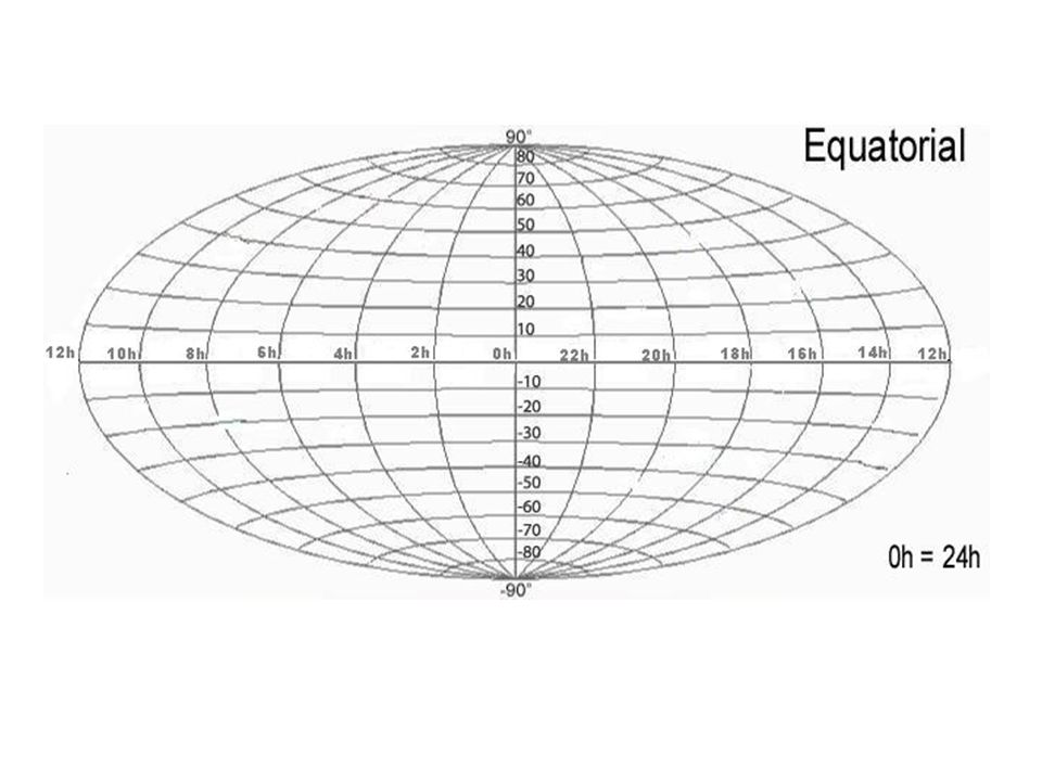
Equatorial System “RA-dec”
Used to catalog objects Celestial Sphere Celestial Equator NCP and SCP Declination (latitude) Right Ascension (longitude) Vernal Equinox it is an extension of the earth onto the sky called the celestial sphere. The fundamental plane is the celestial equator, which is an extension of the earth’s equator upon the celestial sphere. The axis of rotation is an extension of the North – South Pole axis of the earth. Latitude like coordinates are called declination (dec.). Longitude-like coordinates are called right ascension (R.A.). 6. Zero point for RA is Vernal Equinox.
 Right Ascension (longitude) Vernal Equinox. it is an extension of the earth onto the sky called the celestial sphere. The fundamental plane is the celestial equator, which is an extension of the earth’s equator upon the celestial sphere. The axis of rotation is an extension of the North – South Pole axis of the earth. Latitude like coordinates are called declination (dec.). Longitude-like coordinates are called right ascension (R.A.). 6. Zero point for RA is Vernal Equinox.")
25
Declination Angle above Celestial Equator Parallels of Declination
CE = 0 deg NCP = 90 deg SCP = - 90 deg Declination is the angle of the object above the celestial equator. Parallels of declination similar to parallels of latitude. Celestial equator is 0 degrees NCP is 90 degrees and SCP is – 90 degrees

26
Right Ascension Hour circles or “meridians”
Equator = 360 arc deg circumference Measured as hours (24 hours) 1 hr = 15 arc degrees Counterclockwise 0h = vernal equinox The longitudinal lines called hour circles go from the celestial North Pole to the celestial South Pole crossing the equator. R.A. can be expressed in values between 0 deg and 360 deg but is more often given in time units. R.A. is measured counterclockwise or west to east. R.A. can be expressed in values between 0 o and 360 o but is more often given in time units. The 360 deg along the equator is divided into time units of 24 hours (h). One hour equals 15 min of arc
 1 hr = 15 arc degrees. Counterclockwise. 0h = vernal equinox. The longitudinal lines called hour circles go from the celestial North Pole to the celestial South Pole crossing the equator. R.A. can be expressed in values between 0 deg and 360 deg but is more often given in time units. R.A. is measured counterclockwise or west to east. R.A. can be expressed in values between 0 o and 360 o but is more often given in time units. The 360 deg along the equator is divided into time units of 24 hours (h). One hour equals 15 min of arc.")
27
Ecliptic From Earth, Sun ‘s apparent path
Inclined 23.5 deg to Celestial Equator Vernal Equinox Autumnal equinox Winter Solstice Summer Solstice

28
Ecliptic System Earth revolves around sun = ecliptic
Ecliptic is fundamental plane Axis of rotation North Ecliptic Pole South Ecliptic Pole Planets have similar paths around sun

29
Ecliptic System & Planets
Used to study solar system Except for Pluto at 17 degrees Orbital Inclination within 7 degrees of Ecliptic Planet Orbital Inclination Mercury 7.00° Venus 3.39° Earth 0.00° Mars 1.85° Jupiter 1.31° Saturn 2.49° Uranus 0.77° Neptune 1.77° Pluto 17.15° Planet Orbital Inclination Mercury 7.00° Venus 3.39° Earth 0.00° Mars 1.85° Jupiter 1.31° Saturn 2.49° Uranus 0.77° Neptune 1.77° Pluto 17.15°

30
Zodiac Constellations
As earth revolves, sky appearance changes. Constellations around ecliptic called Zodiac

31
Galactic System Study Milky Way and beyond Plane of Galaxy
Inclined about 63 deg to Celestial Equator Used to study objects beyond our Solar System within our Milky Way Galaxy and outside our galaxy in relationship to the plane of the Milky Way. The Galactic Plane, or Galactic Equator, is used as reference plane. This great circle of the celestial sphere best approximates the visible Milky Way. a spiral galaxy, which is very flat with a core that bulges From Earth, the center of the galaxy is in the constellation Sagittarius. The mean plane of the galaxy is inclined at about 63° (62.9°) to the celestial equator.
 to the celestial equator.")
32
Galactic System Fundamental plane = plane of Milky Way
Galactic Equator North Galactic Pole South Galactic Pole Center of Galaxy

33
Galactic Coordinates Galactic Latitude NGP = 90 deg SGP = -90 deg
Galactic Longitude Counterclockwise 0 to 360 deg 0 = center of our galaxy Galactic latitude is measured from the galactic equator at 0 degrees to 90 degrees at the Galactic North Pole and -90 degrees at the Galactic South Pole. north (positive numbers) or south (negative numbers) Galactic longitude is measured eastward along the galactic plane from the galactic center. Galactic longitude (l) is measured in from 0 to 360 deg. east ward along the galactic equator The Longitude Zero Point lies in the direction of the galactic center
 or south (negative numbers) Galactic longitude is measured eastward along the galactic plane from the galactic center. Galactic longitude (l) is measured in from 0 to 360 deg. east ward along the galactic equator. The Longitude Zero Point lies in the direction of the galactic center.")
34
Coordinate Curriculum K-13
Elementary Activities Middle School – Junior High Activities Senior High Activities Aligned to National Standards Involve science, geography, math, language arts, art, problem-solving Introductory, skill-development, and assessment activities

35
Chandra Related to 1. Chandra Classroom-ready activities as Stellar Evolution, Variable Stars, Electromagnetic Spectrum, Imaging for Junior and Senior High 2. ds9 and Visual Observatory 3. Chandra Sky Map

36
Science Olympiad Related to
1.Elementary Science Olympiad events in Starry, Starry Night and Map Reading 2.Reach for the Stars and Road Scholar for Division B 3.Astronomy and Remote Sensing for Division C 4.Trial events as Global Positioning Systems

37
Tools of Astronomy 3-d models, globes, grids, star maps, charts, graphs, quadrant, astrolabe, cross-staff, pinhole protractor, parallax, hand angles binoculars, telescope, star lab, planetarium Computer technology as Chandra Sky Map, ds9, Remote Sensing, GPS, Sky Map programs Coordinates, measurements, angles, relative positions, times, navigation

38
Sample Activity Chandra’s Stellar Evolution poster recently in the Science Teacher magazine Map projections Coordinate grids Problem-solving

39
Chandra’s Stellar Evolution Poster
Available from Chandra website Interactive version on Chandra website Background information and classroom ready materials available.

40
Map Projections Attempts to represent sphere on flat map
Always some distortion Types to emphasize specific regions of sphere

41
Sky Maps Sky maps have East and West reversed
Designed so that when placed above your head, directions will correspond. 3. Maps are usually by month and for regions of earth.

42
Whole Sky (Aitoff) Projection
Whole sky projection is popular with astronomers Projections for Equatorial, Ecliptic, or Galactic Systems

43
Different Reference Planes

47
Chandra Sky Map of images produced by Chandra
Chandra Sky Map of images produced by Chandra Uses the Galactic Coordinate System Clink on colored symbol to access image and information on the Images Will give the Equatorial Coordinates To explore the X-Ray Sky, click on a colored diamond in the sky map. Find out more about Galactic Navigation by taking a tour of the Galactic Coordinate System! Return to Photo Album Revised: January 03, 2005

48
Mercator - Equatorial Region
Shows the regions near the equator Less distortion when put on a flat surface Regions north and south of equator

49
SC001 Equatorial Region Using Equatorial (RA-dec) System
 System")
50
SCOO1 - Declination Declination (latitude-like) from +60 deg above to -60 deg below celestial equator. Degrees, minutes, and seconds of arc

51
SC001 – Right Ascension Right Ascension (longitude-like) from 0-24 hrs. Hours, minutes, seconds Hour circles “meridians” of Right Ascension

52
Polar Region Circumpolar region North version South version

53
SC002 - Declination North Version 30 – 90 deg declination
Parallels of declination Equatorial region not visible

54
SC002 – Right Ascension North polar version RA = 0 to 24 hours
Hour circles or “meridians” Note the chart symbols for objects and magnitude

55
Coordinates Longitude-like coordinate listed first
Polaris Equatorial J2000 B1950 Galactic Ecliptic RA Dec L B Lon Lat 02h31’ 49.08 “ 89o15 ’50.8 “ 01h 48 ’56.79 “ 89o 01’43.4 “ 123o16’ 50.0 “ 26o27 ’41.0 “ 88o34’03.3 “ 66o06’05.3 “ o o o o o o o o Longitude-like coordinate listed first Latitude-like coordinate listed second Equatorial coordinates will reflect epoch – B1950 or J2000

Similar presentations