Download presentation
Presentation is loading. Please wait.

1
IEM Dog and Pony Show Daryl Herzmann @akrherz Iowa State University

2
Who am I and why am I here? 2001 Meteor BS degree Work for Iowa State University Contractor with NWS Co-Creator of NWSChat I like free food (note: remove this before talk if no free food is present) Photo: AP Images
 Photo: AP Images.")
3
See something you don’t like? Yell at me! Photo: AP Images

4
Diplomatic Immunity June 2012 NOAA Team Member of the Month 2007 NOAA Environmental Hero

5
What’s a Dog and Pony Show? Wikipedia - "Dog and pony show" is a colloquial term which has come to mean a highly promoted, often over-staged performance, presentation, or event designed to sway or convince opinion for political, or less often, commercial ends. Photo: Blogspot.com

6
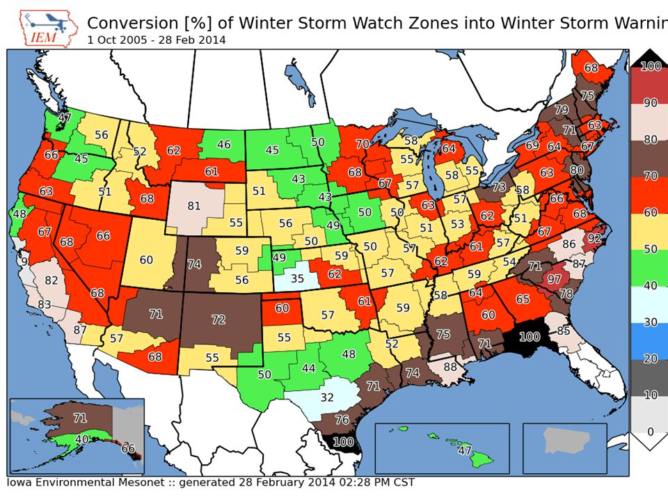
What shall we discuss? Jacob B wanted to know about percentages of winter watches ending up in warnings. My standard ranting about storm based warnings IEM archives and web tools that may help you out – IEM Cow – IEM Raccoon

7
Purpose of my maps is not to show good/bad offices, but show local gradients

8
WATCHES & WARNINGS Chapter 1

9
3,669 UGC Blizzard Watches Blizzard Warning 75.6% Winter Storm Warning 11.1% Wind Chill Warning 11.6% Wind Chill Advisory 7.5% No WWA 5.8% 73,428 UGC Winter Storm Watches Winter Storm Warning 60.6% Winter Weather Advsiory 34.4% Blizzard Warning 6.1% (4,459!!) Snow Advisory 5.3% No WWA 4.6% 1 Oct 2005 – 28 Feb 2014 NWS Conversion of Watches into Warnings (double accounting means totals can be over 100%)
 Snow Advisory 5.3% No WWA 4.6% 1 Oct 2005 – 28 Feb 2014 NWS Conversion of Watches into Warnings (double accounting means totals can be over 100%)")
10
8,702 UGC Blizzard Warnings Winter Storm Watch 51.2% Blizzard Watch 31.3% High Wind Watch 2.7% Wind Chill Watch 0.7% No Watch 26.0% 64,980 UGC Winter Storm Warnings Winter Storm Watch 70.6% Areal Flood Watch 1.2% High Wind Watch 0.8% Blizzard Watch 0.7% No Watch 28.1% 1 Oct 2005 – 28 Feb 2014 NWS Watches before a Warning (double accounting means totals can be over 100%)
")
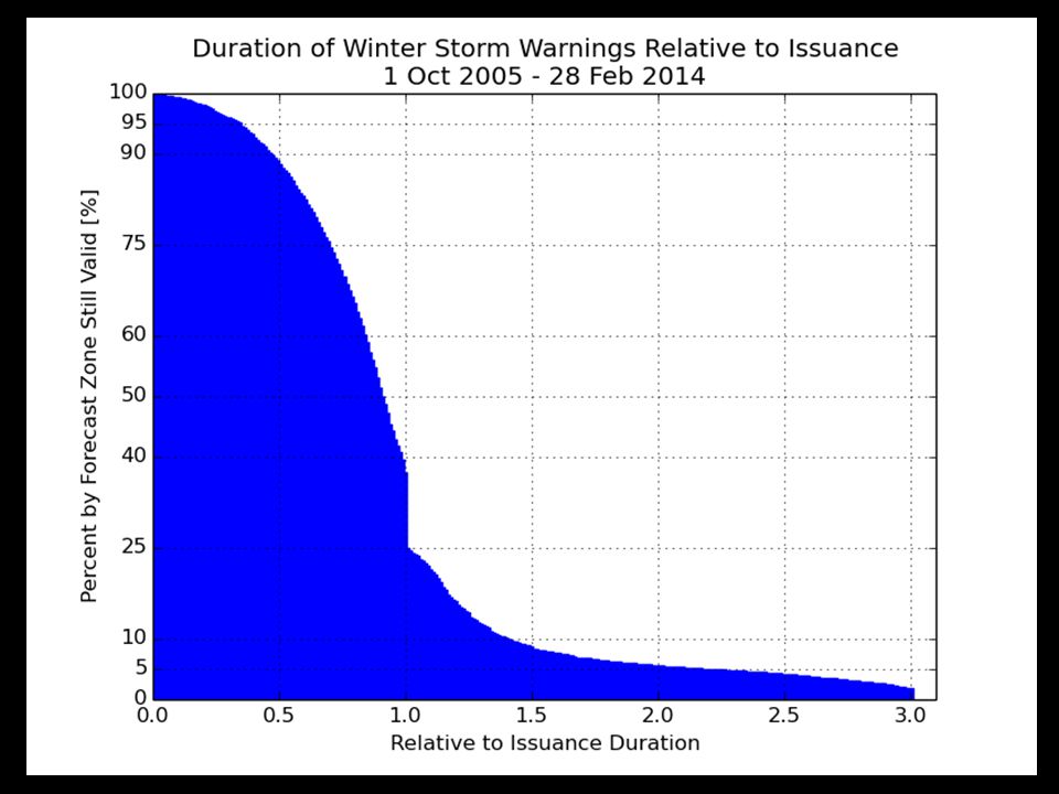
11
10% of Blizzard Warnings are dumped by half way through warning Less than half make it to expiration 5% last double initial issuance

15
54,020 UGC Tornado Warnings Tornado Watch 69.9% SVR Watch 14.9% No Watch 15.7% 409,555 UGC SVR Warnings SVR Watch 36.4% Tornado Watch 22.5% No Watch 41.4% 1 Oct 2005 – 28 Feb 2014 NWS Watches before a Warning (double accounting means totals can be over 100%)
")
18
MY STANDARD “STORM BASED” WARNINGS RANTING Chapter 2

19
Warning Process Evaluation Garden Variety Tornado We had better warn.

20
Warning Process Evaluation Yippee, we can use our fine training and draw a polygon!

21
Warning Process Evaluation I draw my fancy pants polygon out for 30 minutes. I’m done, right?

22
Warning Process Evaluation Gasp, I’m warning for 5 counties! Sirens will go off In all 5! daryl’s here

23
Warning Process Evaluation WarnGen clipping to the rescue! daryl’s stays asleep

24
Warning Process Evaluation Whoa, what happened?

25
Darn it daryl, I came here for stats (or free food), not altruistic hyperbole.
, not altruistic hyperbole.")
26
NWS County SVR/TOR Warnings NEXRAD Storm Based Warnings

27
NWS Storm Based SVR/TOR Warnings

28
1 Oct 2007, warnings changed http://www.weather.gov/sbwarnings/ “Storm-Based Warnings show the specific meteorological or hydrological threat area and are not restricted to geopolitical boundaries.”

29
But what actually changed? NWS: Ignore the red, use the yellow 291 WUUS53 KDMX 182302 SVRDMX IAC007-117-125-135-181-182345- /O.NEW.KDMX.SV.W.0171.100618T2302Z-100618T2345Z/ BULLETIN - IMMEDIATE BROADCAST REQUESTED SEVERE THUNDERSTORM WARNING NATIONAL WEATHER SERVICE DES MOINES IA 602 PM CDT FRI JUN 18 2010 THE NATIONAL WEATHER SERVICE IN DES MOINES HAS ISSUED A * SEVERE THUNDERSTORM WARNING FOR... NORTHWESTERN APPANOOSE COUNTY IN SOUTH CENTRAL IOWA... NORTHEASTERN LUCAS COUNTY IN SOUTH CENTRAL IOWA... SOUTHWESTERN MARION COUNTY IN SOUTH CENTRAL IOWA... MONROE COUNTY IN SOUTH CENTRAL IOWA... SOUTHEASTERN WARREN COUNTY IN SOUTH CENTRAL IOWA... * UNTIL 645 PM CDT * AT 600 PM CDT...NATIONAL WEATHER SERVICE DOPPLER RADAR INDICATED A SEVERE THUNDERSTORM CAPABLE OF PRODUCING GOLF BALL SIZE HAIL...AND DAMAGING WINDS IN EXCESS OF 60 MPH. THIS STORM WAS LOCATED 10 MILES NORTHEAST OF CHARITON...OR 36 MILES SOUTHEAST OF DES MOINES...AND MOVING SOUTHEAST AT 30 MPH. * LOCATIONS IMPACTED INCLUDE... ALBIA...RUSSELL...MELROSE AND LOVILIA. PRECAUTIONARY/PREPAREDNESS ACTIONS... MOVE TO AN INTERIOR ROOM AND STAY AWAY FROM WINDOWS. IF YOU ARE IN A MOBILE HOME...GET OUT NOW...AND SEEK SHELTER IN A REINFORCED BUILDING. A TORNADO WATCH REMAINS IN EFFECT FOR THE WARNED AREA. SEVERE THUNDERSTORMS CAN PRODUCE TORNADOES WITH LITTLE OR NO WARNING. IF A TORNADO IS SPOTTED...IMMEDIATELY MOVE TO THE BASEMENT OR SMALL INTERIOR ROOM OF A REINFORCED BUILDING. TORRENTIAL RAINFALL IS ALSO OCCURRING WITH THIS STORM...AND MAY LEAD TO FLASH FLOODING. DO NOT DRIVE YOUR VEHICLE THROUGH FLOODED ROADWAYS. TURN AROND DON'T DROWN. && LAT...LON 4089 9310 4090 9310 4090 9313 4112 9357 4116 9357 4116 9358 4135 9335 4105 9272 4084 9301 TIME...MOT...LOC 2302Z 300DEG 28KT 4114 9321 WIND...HAIL 60MPH 1.75IN $$ SMALL

30
These aren’t the polygons you’re looking for (Maryland == 26,000 sq km)
")
31
Oh daryl, you and your 1% type academic friends always focused on the outliers…. So another altruism: If less than 50% of warnings are “storm based”, can the program still keep its name?

32
Quiz Question #1 How do you cancel a portion of the warning? Answer: Cancel one of the counties in the warning! IAC181-182341- /O.CAN.KDMX.SV.W.0171.000000T0000Z-100618T2345Z/...THE SEVERE THUNDERSTORM WARNING FOR SOUTHEASTERN WARREN COUNTY IS CANCELLED... IAC007-117-125-135-182345- /O.CON.KDMX.SV.W.0171.000000T0000Z-100618T2345Z/...A SEVERE THUNDERSTORM WARNING REMAINS IN EFFECT FOR SOUTHWESTERN MARION...MONROE...EASTERN LUCAS AND NORTHWESTERN APPANOOSE COUNTIES UNTIL 645 PM CDT...

33
Quiz Question #2 What’s wrong with this picture?

36
Bah, that is La Crosse, we are Chanhassen, fricken Minnesota

40
1 Oct 2007 – 28 Feb 2014: Number of Polygon Vertices (SVR+TOR) 56.5% 8.7%
 56.5% 8.7%")
41
Lets get quantitative Perimeter Influence – How much of the polygon perimeter coincides with a political boundary Size Reduction – How much smaller was the warning than the counties it was issued against.

43
~ 2 % of all warnings

44
Nationwide Average: 65%

45
Storm Based Warning size reduction by number of counties in warning

46
Storm Based Warning # of Counties 0.7% of total

47
Oh daryl, what about this? Perimeter ratio is small So lets compute another metric measuring distance of vertex to county border County Warning

48
Overall Average: 75% Overall: 75%

49
Academic Thought Experiment Take TIME..MOT.LOC and draw my own warning: 1.30 min duration 2.~10 km left 3.~10 and increase to 30 km to the right Which will #win ?

50
Purple box is the warning from the automated algorithm

52
MPX’s TORs 2008-2013 WEATHER BUREAUACADEMIA Average Size (sq km)1003778 Areal Verification13%13.3% Vertex County Intersection64.8%17.8% Size Reduction73.2%Didn’t Compute Perimeter Ratio30%34% Probability of Detection0.640.57 False Alarm Rate0.730.76 Critical Success Index0.230.21 Did the weather bureau #win?
 Areal Verification13%13.3% Vertex County Intersection64.8%17.8% Size Reduction73.2%Didn’t Compute Perimeter Ratio30%34% Probability of Detection False Alarm Rate Critical Success Index Did the weather bureau #win")
53
Chapter 2 Summary ~ 25% of TOR/SVR Warnings are 4 sided Only ~ 2 % of all SVR/TOR warnings are pure county retracements ~ 75% of polygon vertices are guided by county borders SBWs have cut the size of warnings by over 60%, but the number of county based warnings has increased. The Cubs will not win the World Series this year

54
APPS & ARCHIVES Chapter 3

56
COOP Reports by WFO Realtime processing of SHEF data Sortable columns SWE reports are included Snow/Precip ratio is computed for QC help Click on NWSLI to get all reports for the year (Discuss DCP vs COOP)
")
57
IEM Cow SBW Verification based on Local Storm Reports, not Storm Data Provides geometry stats on polygon Handy way to review event data It is ‘live’ and accurate at the time of page load

58
IEM Raccoon OAX’s Dan Nietfeld gave me the idea Create simple and quick Powerpoints of SVR,TOR warning events Intended use: – Internal Office review of events – Quick materials for presentations

59
NEXRAD Archives 1km composite every 5 minutes back to 1995 Single site imagery since 1 Jan 2012 Iowa NEXRADs are backfilled. MPX recently backfilled as well! GIS Ready!

61
NEXRAD Storm Attribute Archive

62
Other Archives of Interest App to quickly view text products by center by date or range of dates Processed SHEF archive back to 2010 Shapefile download of VTEC warnings and Local Storm Reports Nearly complete archive of ASOS/AWOS processed data and raw METARs Processed MOS archive since 2007 Search VTEC Archive by Zone or by Point Archived NWS WWA Map since 9 Apr 2013

63
Time for Questions? Daryl Herzmann 515.294.5978 akrherz@iastate.edu

Similar presentations


>")


 Current Meteorological Uses of GIS and Hydrometeorology 2) Current Research/Studies of Hydrometeorological Data and GIS 3) Future of GIS.>")


