Download presentation
Presentation is loading. Please wait.

1
Which of the following is the result of aeolian deflation? a)desert pavement b)ventifact c)loess d)yardang e)dune
desert pavement b)ventifact c)loess d)yardang e)dune.")
2
Which of the following is the result of aeolian deflation? a)desert pavement b)ventifact c)loess d)yardang e)dune
desert pavement b)ventifact c)loess d)yardang e)dune.")
3
The skipping and bouncing of particles transported by the wind is called _____. a)sedimentation b)compaction c)surface creep d)saltation e)infiltration
sedimentation b)compaction c)surface creep d)saltation e)infiltration.")
4
The skipping and bouncing of particles transported by the wind is called _____. a)sedimentation b)compaction c)surface creep d)saltation e)infiltration
sedimentation b)compaction c)surface creep d)saltation e)infiltration.")
5
a)underneath the dune. b)at the crest. c)on the leeward side. d)on the windward side. e)several feet in front of the windward side. The location of the slip face of a dune is best described as
on the windward side. e)several feet in front of the windward side. The location of the slip face of a dune is best described as.")
6
a)underneath the dune. b)at the crest. c)on the leeward side. d)on the windward side. e)several feet in front of the windward side. 12.04 The location of the slip face of a dune is best described as
on the windward side. e)several feet in front of the windward side The location of the slip face of a dune is best described as.")
7
Choose the best description of a barchan dune. a)long, sinuous ridge-shaped dune aligned parallel with the wind b)pyramidal or star-shaped dune with three or more arms extending outward c)crescent-shaped dune with horns pointing downwind d)circular or elliptical mound with no slipface e)crescent-shaped dune with open end facing upwind
long, sinuous ridge-shaped dune aligned parallel with the wind b)pyramidal or star-shaped dune with three or more arms extending outward c)crescent-shaped dune with horns pointing downwind d)circular or elliptical mound with no slipface e)crescent-shaped dune with open end facing upwind.")
8
Choose the best description of a barchan dune. a)long, sinuous ridge-shaped dune aligned parallel with the wind b)pyramidal or star-shaped dune with three or more arms extending outward c)crescent-shaped dune with horns pointing downwind d)circular or elliptical mound with no slipface e)crescent-shaped dune with open end facing upwind
long, sinuous ridge-shaped dune aligned parallel with the wind b)pyramidal or star-shaped dune with three or more arms extending outward c)crescent-shaped dune with horns pointing downwind d)circular or elliptical mound with no slipface e)crescent-shaped dune with open end facing upwind.")
9
Choose the best description of a longitudinal dune. a)long, sinuous ridge-shaped dune aligned parallel with the wind b)pyramidal or star-shaped dune with three or more arms extending outward c)crescent-shaped dune with horns pointing downwind d)circular or elliptical mound with no slipface e)crescent-shaped dune with open end facing upwind
long, sinuous ridge-shaped dune aligned parallel with the wind b)pyramidal or star-shaped dune with three or more arms extending outward c)crescent-shaped dune with horns pointing downwind d)circular or elliptical mound with no slipface e)crescent-shaped dune with open end facing upwind.")
10
Choose the best description of a longitudinal dune. a)long, sinuous ridge-shaped dune aligned parallel with the wind b)pyramidal or star-shaped dune with three or more arms extending outward c)crescent-shaped dune with horns pointing downwind d)circular or elliptical mound with no slipface e)crescent-shaped dune with open end facing upwind
long, sinuous ridge-shaped dune aligned parallel with the wind b)pyramidal or star-shaped dune with three or more arms extending outward c)crescent-shaped dune with horns pointing downwind d)circular or elliptical mound with no slipface e)crescent-shaped dune with open end facing upwind.")
13
Oceans

14
Ocean Topography

15
Physical Structure of the Ocean

16
Littoral Zone

17
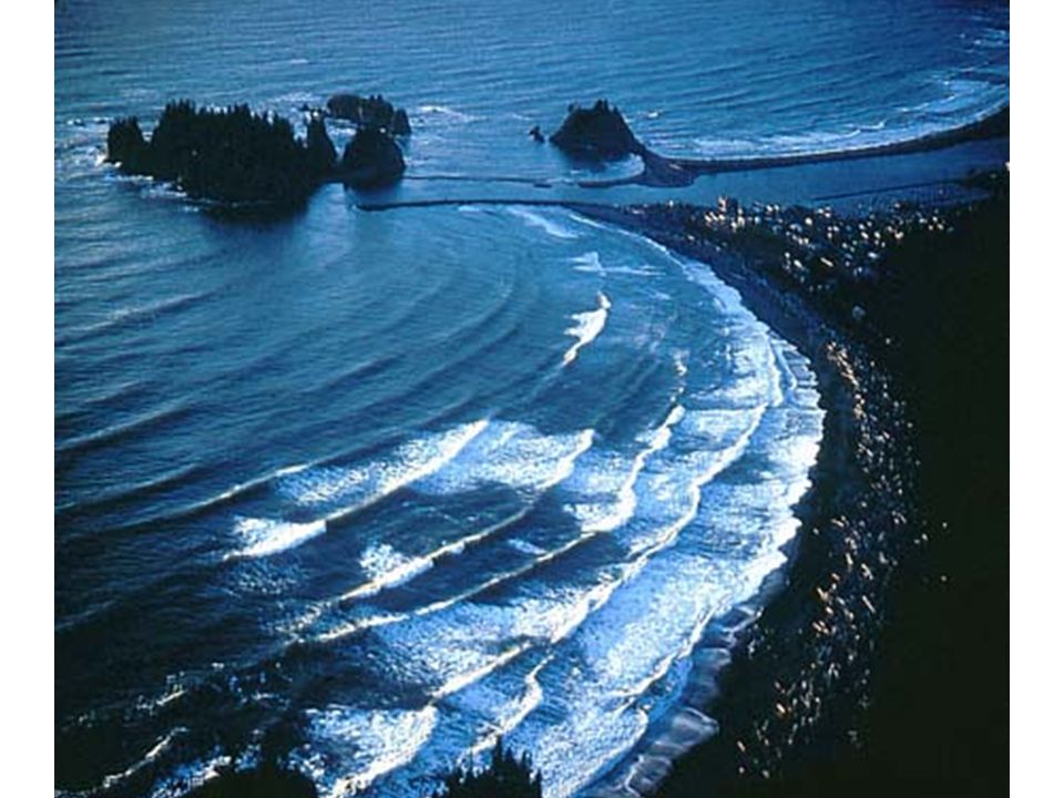
Wave Formation

19
Wavelength Distance from one wave crest to the next Wave height The distance between trough and crest Wave period The time taken for two crests to pass a given point (remains almost constant) = V * P The wavelength,, is the product of its velocity and period.
 = V * P The wavelength,, is the product of its velocity and period.")
20
Wave Properties The energy source for both coastal erosion and sediment transport are the ocean waves generated by the frictional effect of the winds incident on the ocean surface (1) Kinetic Energy: The motion of the water within the wave. (2) Potential Energy: Due to the position of water above the wave trough. Wave energy increases with wind speed and fetch
 Potential Energy: Due to the position of water above the wave trough. Wave energy increases with wind speed and fetch.")
21
Wave motion (a)Ocean depth > ½ wavelength - waves not affected by ocean floor (b) Ocean depth < ½ wavelength - wave height increases and wavelength decreases The wave becomes more peaked “Breakers” form Breaking of waves: conversion of potential to kinetic energy Work done on the shoreline
Ocean depth > ½ wavelength - waves not affected by ocean floor (b) Ocean depth < ½ wavelength - wave height increases and wavelength decreases The wave becomes more peaked Breakers form Breaking of waves: conversion of potential to kinetic energy Work done on the shoreline")
22
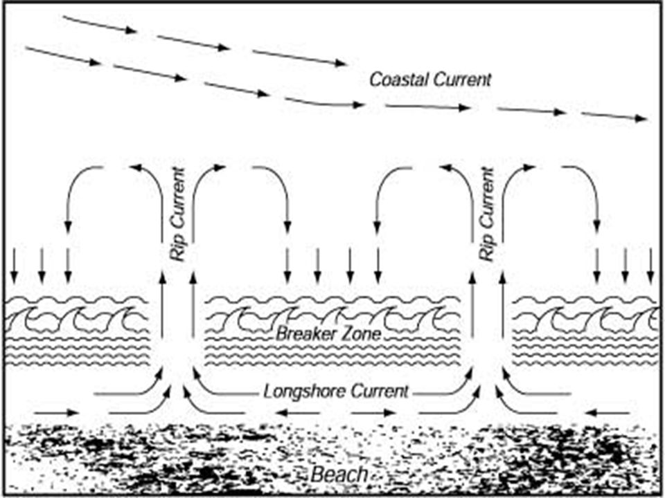
Transport of Sediments by Wave Action Rock particles are eroded from one area and deposited elsewhere. Wave refraction affects this process. Beach Drift: Swash and backwash rarely occur in exactly opposite directions Upward movement occurs at some oblique angle Backward movement occurs at right angles to the beach. This creates lateral movement of particles (beach drift)
.")
23
Decrease in wavelength as waves approach a shoreline

24
Wave Refraction Straight shoreline -drag exerted by the ocean floor causes waves to break parallel with the shoreline. The direction of travel of a wave varies as it approaches an indented coast. Crests approaching the headlands experience the drag of the ocean floor first, which causes: 1.Increase in wave height 2.Decrease in wavelength 3.Decrease in velocity

26
Longshore Current and Beach Drift

27
Longshore Currents

29
Rip currents form when waves are pushed over sandbars. The weight of excess water near the shore can ‘rip’ an opening in the sandbar, causing water to rush seaward. Rip Currents Source: NOAA

30
Rip Current

35
Tidal forces Tides enhanced during full Moon and new Moon Sun-Moon-Earth closely aligned

36
Influence of Perigee, Apogee, Perihelion and Aphelion on the Earth’s Tides Stronger for perigee and perihelion

37
Annapolis Tidal Power Generating Station

38
Hopewell Rocks, New Brunswick “flower pot rocks”

39
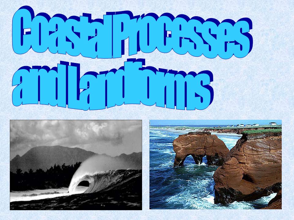
Coastal Processes and Landforms Erosional and depositional landforms of coastal areas are the result of the action of ocean waves. Erosional LandformsDepositional landforms Sea CliffsBeaches Wave-cut NotchesBarrier Spit CavesBaymouth Bar Sea stacksLagoon Sea archesTombolo

40
Erosional Coastal Landforms Along rugged, high-relief, tectonically-active coastlines Sea cliffs A tall, steep rock face, formed by the undercutting action of the sea Wave-cut notches A rock recess at the foot of a sea cliff where the energy of waves is concentrated Sea Caves Caves form in more erosive sediment when the rock does not fully collapse in a deeply-notched environment

43
Wave-cut platform Horizontal benches in the tidal zone extending from the sea cliff out into the sea If the sea level relative to the land changes over time (becoming lower with respect to the land due to uplift), multiple wave cut platforms (terraces) result 1 3 2 5 4 6 http://www.rgs.edu.sg/events/geotrip/cliff.html
, multiple wave cut platforms (terraces) result")
44
Erosional Features

45
Depositional Coastal Features

46
Littoral Drift

47
Barrier Spit Material transported by littoral drift deposited along ridge, extending outward from a coast in an area with weak offshore currents If the spit grows to completely block an embayment, it is called a bay barrier or baymouth bar A lagoon is a body of water behind the barrier

48
Puget Sound, WA

49
Bay Barrier

50
Near Eureka, CA

52
Coastal Straightening Figure 13.8 Copyright © 2010 Pearson Education, Inc.Christopherson, Elemental Geosystems, Sixth Edition

54
Frost Island, WA

55
A tombolo occurs when sediment deposits connect the shoreline with an offshore sea stack or island

56
Rebounding Coast isostatic rebound

57
Barrier Islands

58
Chandeleur Islands

60
Coral Reefs Coral: Marine animal in symbiotic relationship with algae Saclike body called a polyp Biodiverse, but bleaching a problem due to pollution, sedimentation, warming, and variable salinity. Figure 13.17

61
Coral Reef Formation and Forms

62
Coral Reef Formations

63
Coastal Salt Marsh

65
Mangroves

66
Which of the following is NOT a coastal feature that is the direct result of the erosion of waves? a)wave-cut platform b)notched cliff c)barrier spit d)sea arch e)sea cave
wave-cut platform b)notched cliff c)barrier spit d)sea arch e)sea cave.")
67
Which of the following is NOT a coastal feature that is the direct result of the erosion of waves? a)wave-cut platform b)notched cliff c)barrier spit d)sea arch e)sea cave
wave-cut platform b)notched cliff c)barrier spit d)sea arch e)sea cave.")
68
Which of the following is NOT a depositional coastal feature? a)bay barrier b)beach c)barrier spit d)sea stack e)tombolo
bay barrier b)beach c)barrier spit d)sea stack e)tombolo.")
69
Which of the following is NOT a depositional coastal feature? a)bay barrier b)beach c)barrier spit d)sea stack e)tombolo
bay barrier b)beach c)barrier spit d)sea stack e)tombolo.")
70
Which of the following statements about the chemical composition of seawater is false? a)Seawater that is less saline than average is called brackish. b)Seawater that is more saline than average is called brine. c)Seawater in equatorial regions is slightly higher in salinity than average. d)Seawater is generally lower in salinity near continents. e)The average salinity is 35 parts per thousand.
Seawater that is less saline than average is called brackish. b)Seawater that is more saline than average is called brine. c)Seawater in equatorial regions is slightly higher in salinity than average. d)Seawater is generally lower in salinity near continents. e)The average salinity is 35 parts per thousand..")
71
Which of the following statements about the chemical composition of seawater is false? a)Seawater that is less saline than average is called brackish. b)Seawater that is more saline than average is called brine. c)Seawater in equatorial regions is slightly higher in salinity than average. d)Seawater is generally lower in salinity near continents. e)The average salinity is 35 parts per thousand.
Seawater that is less saline than average is called brackish. b)Seawater that is more saline than average is called brine. c)Seawater in equatorial regions is slightly higher in salinity than average. d)Seawater is generally lower in salinity near continents. e)The average salinity is 35 parts per thousand..")
72
The physical structure of the ocean includes a)a warm surface zone that extends to a depth of 2.5 kilometers. b)a frozen zone that lies about 5 kilometers deep in tropical regions. c)a frozen zone that may be only 0.5 kilometers deep in polar regions. d)a zone of mixed water temperatures that extends from the surface to the ocean floor. e)a thermocline transition zone, which is a region of decreasing temperature gradient.
a frozen zone that lies about 5 kilometers deep in tropical regions. c)a frozen zone that may be only 0.5 kilometers deep in polar regions. d)a zone of mixed water temperatures that extends from the surface to the ocean floor. e)a thermocline transition zone, which is a region of decreasing temperature gradient..")
73
The physical structure of the ocean includes a)a warm surface zone that extends to a depth of 2.5 kilometers. b)a frozen zone that lies about 5 kilometers deep in tropical regions. c)a frozen zone that may be only 0.5 kilometers deep in polar regions. d)a zone of mixed water temperatures that extends from the surface to the ocean floor. e)a thermocline transition zone, which is a region of decreasing temperature gradient.
a frozen zone that lies about 5 kilometers deep in tropical regions. c)a frozen zone that may be only 0.5 kilometers deep in polar regions. d)a zone of mixed water temperatures that extends from the surface to the ocean floor. e)a thermocline transition zone, which is a region of decreasing temperature gradient..")
74
In the littoral zone, the beach (shore) zone includes a)the offshore zone. b)cliffs. c)the backshore. d)offshore bars. e)the foreshore.
cliffs. c)the backshore. d)offshore bars. e)the foreshore..")
75
In the littoral zone, the beach (shore) zone includes a)the offshore zone. b)cliffs. c)the backshore. d)offshore bars. e)the foreshore.
cliffs. c)the backshore. d)offshore bars. e)the foreshore..")
76
Spring tides occur under which of the following circumstances? a)Meltwater from snowfields lowers the salinity in estuaries. b)All latitudes experience equal day and night. c)The Sun, Moon, and Earth are positioned in a straight line. d)The Sun’s rays are directly overhead at the equator. e)The Moon is positioned 90° to Earth and the Sun.
Meltwater from snowfields lowers the salinity in estuaries. b)All latitudes experience equal day and night. c)The Sun, Moon, and Earth are positioned in a straight line. d)The Sun’s rays are directly overhead at the equator. e)The Moon is positioned 90° to Earth and the Sun..")
77
Spring tides occur under which of the following circumstances? a)Meltwater from snowfields lowers the salinity in estuaries. b)All latitudes experience equal day and night. c)The Sun, Moon, and Earth are positioned in a straight line. d)The Sun’s rays are directly overhead at the equator. e)The Moon is positioned 90° to Earth and the Sun.
Meltwater from snowfields lowers the salinity in estuaries. b)All latitudes experience equal day and night. c)The Sun, Moon, and Earth are positioned in a straight line. d)The Sun’s rays are directly overhead at the equator. e)The Moon is positioned 90° to Earth and the Sun..")
78
Which is responsible for concentrating wave action onto headlands? a)wave refraction b)neap tides c)rip currents d)longshore currents e)waves of transition
wave refraction b)neap tides c)rip currents d)longshore currents e)waves of transition.")
79
Which is responsible for concentrating wave action onto headlands? a)wave refraction b)neap tides c)rip currents d)longshore currents e)waves of transition
wave refraction b)neap tides c)rip currents d)longshore currents e)waves of transition.")
80
The net transport of water parallel to the shoreline that is the result of breakers striking at an angle to the beach is(are) _____. a)longshore current b)deflation c)spring tides d)waves of translation e)interference
longshore current b)deflation c)spring tides d)waves of translation e)interference.")
81
The net transport of water parallel to the shoreline that is the result of breakers striking at an angle to the beach is(are) _____. a)longshore current b)deflation c)spring tides d)waves of translation e)interference
longshore current b)deflation c)spring tides d)waves of translation e)interference.")
82
Coral bleaching may be the result of _____. a)the warming of sea-surface temperatures b)dumping of chemicals and pollutants on fringing reefs c)increased human recreation in coral reef areas d)the erosive action of tsunamis e)increased wave action on fringing reefs
the warming of sea-surface temperatures b)dumping of chemicals and pollutants on fringing reefs c)increased human recreation in coral reef areas d)the erosive action of tsunamis e)increased wave action on fringing reefs.")
83
Coral bleaching may be the result of _____. a)the warming of sea-surface temperatures b)dumping of chemicals and pollutants on fringing reefs c)increased human recreation in coral reef areas d)the erosive action of tsunamis e)increased wave action on fringing reefs
the warming of sea-surface temperatures b)dumping of chemicals and pollutants on fringing reefs c)increased human recreation in coral reef areas d)the erosive action of tsunamis e)increased wave action on fringing reefs.")
84
Which of the following tend to form along coastlines north of 30º N latitude in the Northern Hemisphere? a)mangrove swamps b)salt marshes c)coral reefs d)tombolos e)atolls
mangrove swamps b)salt marshes c)coral reefs d)tombolos e)atolls.")
85
Which of the following tend to form along coastlines north of 30º N latitude in the Northern Hemisphere? a)mangrove swamps b)salt marshes c)coral reefs d)tombolos e)atolls
mangrove swamps b)salt marshes c)coral reefs d)tombolos e)atolls.")
Similar presentations


 tectonics active passive sea-level change may vary widely causes global (eustatic) from +6m to -125.>")


