Download presentation
Presentation is loading. Please wait.

1
TIDES Chapter 8

2
10 1 10 0 10 -1 10 -2

3
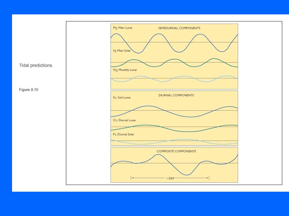
A tide has a waveform. - Shallow water wave (large L compared to water depth). -Crest of wave is high tide. -Trough of wave is low tide. -Period is time between successive high (or low) tides. -Wave height of tidal wave is the range crest trough L
 tides. -Wave height of tidal wave is the range crest trough L.")
4
I.TIDAL RANGES VARY OVER THE DAILY (DIURNAL) PERIOD (vary geographically): 1.Diurnal a)One low one high tide each day. b)Tidal period of 24hrs 25 min. 2.Semidiurnal a)Two high and two low tides each day. b)Tidal period of 12 hrs 25 min. 3.Mixed a)Two high and two low tides of dissimilar range. b)Periods between 12 hrs 25 min & 24 hrs 25 mins.
Tidal period of 24hrs 25 min. 2.Semidiurnal a)Two high and two low tides each day. b)Tidal period of 12 hrs 25 min. 3.Mixed a)Two high and two low tides of dissimilar range. b)Periods between 12 hrs 25 min & 24 hrs 25 mins..")
5
Diurnal and Semidiurnal

6
Real tides are the result Of constructive and destructive wave interference of multiple tidal components, making a “mixed tide”.

9
1.Spring tides a)The low and high tides each month with highest range. b)Coincides with full and new moons. 2.Neap tides a)The low and high tides each month with lowest range. b)Coincides with first and last quarter moons. TIDAL RANGES ALSO VARY OVER THE MONTLY PERIOD, WITH CYCLE OF MOON
Coincides with full and new moons. 2.Neap tides a)The low and high tides each month with lowest range. b)Coincides with first and last quarter moons. TIDAL RANGES ALSO VARY OVER THE MONTLY PERIOD, WITH CYCLE OF MOON.")
10
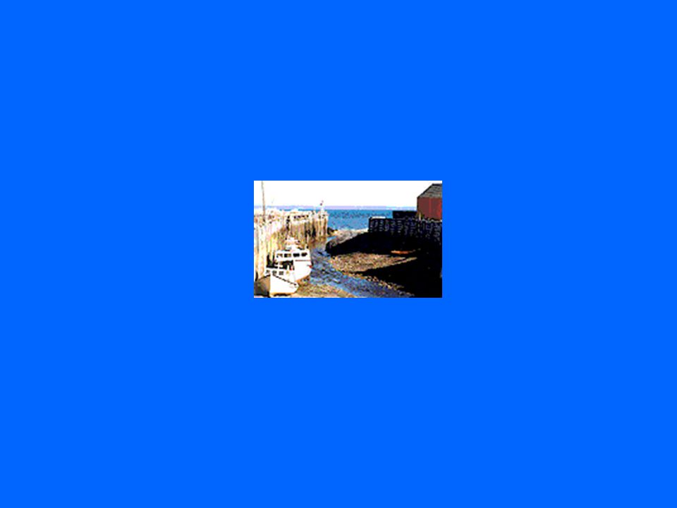
Examples of Tidal Records

11
Two Models of Tides 1.Equilibrium model a)(over)-simplified representation. 2.Dynamic model a)Adds more realistic complexity. How to account for the temporal and geographic variations of the tides???
Adds more realistic complexity. How to account for the temporal and geographic variations of the tides .")
12
Assumptions: –Earth’s surface is covered by seawater of infinite depth. –Wave is progressive. –Wave is in equilibrium with tide generating forces (gravitational and centrifugal). Equilibrium Model of Tides
. Equilibrium Model of Tides.")
13
TIDES RESULT FROM TWO FORCES: 1.Gravitational force of moon & sun 2.Centrifugal force

14
Gravitational effect Centrifugal effect Combined gravitation & centrifugal.

15
Equilibrium Tides- Declination

16
Spring and Neap Tides

19
So, to summarize… The equilibrium model of the tides helps explain: 1.Geographic variation of tidal periods (diurnal, semidiurnal, mixed). a.Moon’s declination causes latitudinal variation in sizes of ‘bulges’ seen at a point on the rotating earth. 2.Temporal variation of tidal periods (spring, neap). a)Moon’s phases and alignment with moon & sun.
. a)Moon’s phases and alignment with moon & sun..")
20
Add more complexity to the simple equilibrium model. To make more realistic we must consider: -shape of ocean basins, land masses -coriolis deflection & geostrophic flow The Dynamic Model of Tides

22
Rotary Tidal Flow in NH P1P1 P2P2 P 1 > P 2 Remember: P = gh N W E S Tidal wave crest

23
Rotary Tidal Flow in NH Remember: P = gh N PG CD W E S

24
Rotary Tidal Flow in NH P2P2 Remember: P = gh N CD W E S PG CD

25
Rotary Tidal Flow in NH P2P2 Remember: P = gh N W E S P2P2 CD X PG

26
Rotary Tidal Flow in NH Remember: P = gh N W E S PG X CD

27
Rotary Tidal Motion Rotary motion of tide is counter-clockwise in NH and clockwise in SH.

28
Amphidromic System

32
Some other terminology… Tidal resonance period of main tidal component equals natural period of basin. Tidal Bore “wall” of water that surges upriver with advancing tide Tidal currents Flood current in advancing tide Ebb currents in retreating tide

33
2-5Geophysical Surveying THE END

36
In the dynamic model of tides, movement of tides across ocean basins is deflected by the Coriolis effect and is blocked by continental landmasses. The result is a rotary wave, which each day completes two cycles around the basin if the tide is semidiurnal or one cycle if it is diurnal. 8-2Origin of the Tides

37
High tide at the ocean basin’s western edge creates a pressure gradient sloping downward towards the east. As water flows down the gradient, the Coriolis effect deflects water towards the equator, where it accumulates and establishes a pressure gradient sloping downward towards the pole. 8-2Origin of the Tides

38
Water flowing down this gradient is deflected eastward, forming a pressure gradient sloping downward to the west. Westward flow along this gradient is diverted poleward forming a pressure gradient sloping downward toward the equator. Finally, the flow toward the equator is deflected westward, completing the cycle. The rotary cycle of the tide is called an amphidromic system. 8-2Origin of the Tides

39
A rotary wave is part of an amphidromic system (rotary standing wave) in which the wave progresses about a node (no vertical displacement) with the antinode (maximum vertical displacement) rotating about the basin’s edges. 8-2Origin of the Tides

40
Cotidal lines connect points on the rotary wave that experience high tide at the same time. Cotidal lines are not evenly spaced because tides are shallow water waves and their celerity depends upon water depth. Corange circles are lines connecting points which experience the same tidal range. –The lines form irregular circles which are concentric about the node. –Tidal range increases outward from the node. 8-2Origin of the Tides

41
Amphidromic systems rotate clockwise in the southern hemisphere and counterclockwise in the northern hemisphere because of the difference in the direction of Coriolis deflection. Irregular coastlines distort the rotary motion. Actual tide expressed at any location is a composite of 65 different tidal components. 8-2Origin of the Tides

42
In long and narrow basins tides can not rotate. Currents in these basins simply reverse direction between high and low tide, flowing in with the high tide and out with the low tide. Cotidal and corange lines are nearly parallel to each other. Tidal ranges increase if a bay tapers landward because water is funneled towards the basin’s narrow end. Tides in Small and Elongated Basins 8-3

43
Tidal resonance occurs if the period of the basin is similar to the tidal period. Resonance can greatly enhance the tidal range. A tidal bore is a wall of water that surges upriver with the advancing high tide. Tides in Small and Elongated Basins 8-3

44
The movement of water towards and away from land with the high and low tides, respectively, generates tidal currents. Flood current is the flow of water towards the land with the approaching high tide. Ebb current is the flow of water away from the land with the approaching low tide. Offshore the tidal currents inscribe a circular path over a complete tidal cycle. Nearshore the tidal currents produce simple landward and then seaward currents. Tidal Currents 8-4

45
Electricity can be generated from tidal currents if the tidal range is greater than 5 m in a large bay connected to the ocean by a narrow opening. A dam is constructed across the opening and water is allowed to flow into and out of the bay when sufficient hydraulic head exist to drive turbines and generate power. Power from Tides 8-5

46
Power from the Tides

Similar presentations


 –Amphidromic.>")


