Download presentation
Presentation is loading. Please wait.

1
Briefing on Hydrogeology National Center for Remote Sensing Amin Shaban

2
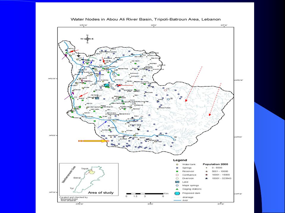
Location of the study area

3
Water Resources 1. Precipitation *It ranges between 600-1000mm *According to Thiessen and Isohyts methods, the average PPt.=830mm. This is equivalent to a volume of 285 Mm 3 /years *25-35% of this volume is derived from snowmelt 2. Surface water * Only one permanent river is located : Abou Ali River, and there are a treble number of intermittent streams * Springs (on-land): Thee are around 75 issuing springs, with average discharge of about 20l/sec. This is equivalent to 50 Mm 3 /year * Springs (submarine): a common phenomenon along the Lebanese coastal line. There are ten of this type (littoral & off-shore), with total volume of 300 Mm 3 /year
: Thee are around 75 issuing springs, with average discharge of about 20l/sec. This is equivalent to 50 Mm 3 /year * Springs (submarine): a common phenomenon along the Lebanese coastal line. There are ten of this type (littoral & off-shore), with total volume of 300 Mm 3 /year.")
4
Physical and hydrological properties of a major rivers in/nearby the SMART area River Average annual discharge (Mm3/yr) Length (km) Area (km2) Relief gradient (m/km) Drainage density (km/km2) Major sources of replenishment Al-Bared16837284251.05 Nabaa Essoukar and the snowmelt Abou Ali36942482461.20 Nabaa Kadisha, N. Mar Sarkis, N. Rachaaine and snowmelt Al-Jouz8233196420.92 Nabaa El-Jouz, N. Dalle and snowmelt

5
Volume of precipitated and evapotranspirated water from watersheds in SMART area Major watershedsIntermediate watersheds Minor watersheds No. Volume of precipitated water (Mm3/yr) Volume of evapotranspir atedated water (Mm3/yr) No. Volume of precipitated water (Mm3/yr) Volume of evapotranspir atedated water (Mm3/yr) No. Volume of precipitated water (Mm3/yr) Volume of evapotranspir atedated water (Mm3/yr) 1 11355 1 2916.5 1 126.5 2 14673 2 3421 2 11.56 3 10558 3 697 3 21.5 4 224148 4 41.5 4 11.56 5 504265 5 52 5 3617 6 6450 6 8.53.5 6 5.52.5 7 122117 7 94 7 115 8 34.515 8 52.5 9 146.5
 Volume of evapotranspir atedated water (Mm3/yr) No. Volume of precipitated water (Mm3/yr) Volume of evapotranspir atedated water (Mm3/yr) No. Volume of precipitated water (Mm3/yr) Volume of evapotranspir atedated water (Mm3/yr)")
6
Major issuing springs in SMART area NoSpringDischarge (m 3 /sec) Source rock formation Spring type 1El-Jouz 2.20 C4C4 Karstic 2Dalle 1.93 C 1- J 6 Overflow 3Kadisha 1.50 C4C4 Fault 4Mar Sarkis 0.5 C4C4 Fault 5Essoukar 0.3 C 3- C 4 overflow
 Source rock formation Spring type 1El-Jouz 2.20 C4C4 Karstic 2Dalle 1.93 C 1- J 6 Overflow 3Kadisha 1.50 C4C4 Fault 4Mar Sarkis 0.5 C4C4 Fault 5Essoukar 0.3 C 3- C 4 overflow")
7
Major submarine springs in the SMART area NoLocalityCoordinates (longitude & latitude) Main flow featuring Estimated yield (l/sec) 1 Hai El-Maqateh 35º 54‘ 46“ 34º 28‘ 30" Apparent surface water seepages that lie parallel to the coast with a spreading of about 10-15m 60 2 El-Bahssas 35º 44‘ 10“ 34º 25‘ 20" Water seeps among rocky islets extending about 100m into the sea 200 3 El-Bahssas-Abou Halaqa 35º 48‘ 58“ 34º 25‘ 10" As above, but with 700m extending 600 4 Chekka-1 35º 43‘ 35“ 34º 20‘ 35" Artesian spring of 25m off-shore and 5- 10m diameter 500 5 Chekka-2 35º 43‘ 06“ 34º 20‘ 28" As above (700m off-shore & 55-60m diameter) 2000 6 Chekka-3 35º 43‘ 26“ 34º 20‘ 11" As above (300m off-shore & 15-20m diameter) 1500 7 Chekka-4 35º 39‘ 11“ 34º 20‘ 10" As above (300m off-shore & 10-15m diameter) 1000 8 Fadouss 35º 39‘ 11“ 34º 13‘29" Water seeps parallel to the coast by a width ranges between 50-250m 60 9 Madfoun-1 35º 538‘ 54 “ 34º 12‘ 29" Irredgular water seepage lateral and linear 50-300m 120 10 Madfoun-2 35º 38‘ 58“ 34º 12‘ 26" Linear flow into the sea by a 50-150m 60
 Main flow featuring Estimated yield (l/sec) 1 Hai El-Maqateh 35º 54‘ 46 34º 28‘ 30 Apparent surface water seepages that lie parallel to the coast with a spreading of about 10-15m 60 2 El-Bahssas 35º 44‘ 10 34º 25‘ 20 Water seeps among rocky islets extending about 100m into the sea El-Bahssas-Abou Halaqa 35º 48‘ 58 34º 25‘ 10 As above, but with 700m extending Chekka-1 35º 43‘ 35 34º 20‘ 35 Artesian spring of 25m off-shore and 5- 10m diameter Chekka-2 35º 43‘ 06 34º 20‘ 28 As above (700m off-shore & 55-60m diameter) Chekka-3 35º 43‘ 26 34º 20‘ 11 As above (300m off-shore & 15-20m diameter) Chekka-4 35º 39‘ 11 34º 20‘ 10 As above (300m off-shore & 10-15m diameter) Fadouss 35º 39‘ 11 34º 13‘29 Water seeps parallel to the coast by a width ranges between m 60 9 Madfoun-1 35º 538‘ 54 34º 12‘ 29 Irredgular water seepage lateral and linear m Madfoun-2 35º 38‘ 58 34º 12‘ 26 Linear flow into the sea by a m 60")
8
Water Resources 3. Groundwater * The area of study is almost covered by impervious rocks and thick alluvial deposits. However, the recharge into subsurface strata is relatively low. So far, the located aquifers are fed from the neighboring areas along the tilted bedding planes * These aquifers are mostly characterized the secondary porosity, which is attributed to fracturing and karstification.

9
Hydrostratigraphic characteristics of major aquifers in the SMART area Aquifer Sannine-Ghazir limestone (C 4 ) Bikfaya limestone (J 6 ) Lithology Moderate to thick bedded and massive, highly fractured, jointed, chertified and well karstified dolomitic limestone and limestone with some thin marly beds Thick bedded to massive, highly fissured, jointed and well karstified dolomitic limestone and limestone Transmissivity (m3/sec) 2.3 x 10 -6 to 3.2 x 10 -6 2.5 x 10 -6 to 3.5 x 10 -6 Storage capacity (m3/hr/1m) 1.17 x 10 -6 1.20 x 10 -6 Thickness (m) 700200 Infiltration rate (%) 35-4040-45 Run-off (%) 5-10 Degree of karstificationSlightly high to highLocally high
 Bikfaya limestone (J 6 ) Lithology Moderate to thick bedded and massive, highly fractured, jointed, chertified and well karstified dolomitic limestone and limestone with some thin marly beds Thick bedded to massive, highly fissured, jointed and well karstified dolomitic limestone and limestone Transmissivity (m3/sec) 2.3 x to 3.2 x x to 3.5 x Storage capacity (m3/hr/1m) 1.17 x x Thickness (m) Infiltration rate (%) Run-off (%) 5-10 Degree of karstificationSlightly high to highLocally high")
Similar presentations