Download presentation
Presentation is loading. Please wait.

1
Protecting Shorelands as Part of the Hydroelectric Relicensing Process - Lessons from New England Kenneth Kimball Research Department Appalachian Mountain Club

2
Incredible Opportunities ECPA - landscape change in FERC mandate in 1986 Rivers becoming much cleaner due to CWA, increased public interest and available resources ‘Class of 1993’ dams and after has created huge opportunities & challenges Hydropower Reform Coalition (NGO’s put major emphasis to educate the public on impacts of dams and that the public ‘owns’ the rivers) Web access to FERC filings, decisions More public and visible relicensing process
 Web access to FERC filings, decisions More public and visible relicensing process")
3
Competing Legitimate Demands Hydro generation aquatic resource flows recreation boating flows reservoir level controls shoreland protection fish passage

4
Variable flows cause - Lost aquatic habitat Rivers on Rivers off - Lost recreational opportunities

5
Aquatic Resource and Recreation Flows

6
Recreational Access

7
Abbreviated History of Settlements FERC distrusted settlements (loss of authority) FERC receives settlements through the traditional process FERC develops APEA process that encourages settlements FERC accepts settlements, but as a Chinese “menu” - rejects elements it believes are outside its jurisdiction FERC develops ILP licensing process 2003
 FERC receives settlements through the traditional process FERC develops APEA process that encourages settlements FERC accepts settlements, but as a Chinese menu - rejects elements it believes are outside its jurisdiction FERC develops ILP licensing process 2003")
8
What Makes a Settlement Work Need for a respected moderator or facilitator (NGO, gov’t agency, applicant consultant, FERC ADR - all have worked) establish negotiation ground rules have confidentiality agreements focus on substance and minimize lawyers create supporting record for decisions Meet frequently and keep progress moving on elements where agreement can be reached Keep fact based/use models Understand rarely does any one get 100% of their ‘special’ interest avoid infighting, e.g. boaters vs fishermen, land protection vs. flows certain elements may be outside the realm for negotiations (basic 401 requirements, historic, etc.) be clear on whether all settlement elements are expected to be or can be in final license articles
 be clear on whether all settlement elements are expected to be or can be in final license articles.")
10
> 40,000 acres protected $20 million in river enhancement funds >200 miles of improved river flows protected boating opportunities improved fisheries and wildlife habitat Major Watershed Gains in NE

11
Deerfield Settlement changed from single interest to multi-interest settlement New England Power (USGen) Appalachian Mountain Club American Rivers American Whitewater Conservation Law Foundation Deerfield River Compact Deerfield River Watershed Association MA Division of Fisheries and Wildlife MA Dept. of Environmental Management New England FLOW National park Service Trout Unlimited US Environmental Protection Agency US Fish and Wildlife Service VT Agency of Natural Resources

12
Deerfield River (85 MW) 40 -year license ability to continue peaking 18,350 acres in perm conservation easements $100,00 enhancement fund relocate endangered plant 12 miles of dry bypass now w/ min flow augmented min. flow in another 33 miles improved water quality reservoir drawdown limitations over 100 whitewater releases 37 new or upgraded recreational facilities 3 down and 1 upstream fish passage

13
Deerfield River flow enhancement

14
Deerfield River land protection

15
Fifteen Mile Falls (settlement negotiated in 8 months with pending sale, APEA w/ coordinator) New England Power (US Gen) Governors of NH and VT Appalachian Mountain Club Connecticut River Joint Commissions Connecticut River Watershed Council Conservation Law Foundation National park Service NH Dept. of Environmental Services NH Fish and Game Department North Country Council Northeastern VT Development Council Trout Unlimited US Environmental Protection Service US Fish and Wildlife Service VT Agency of Natural Resources

16
Fifteen Mile Falls (369 MW) 40-year license ability to continue peaking operation 12,000 acres into permanent conservation easements $10.5 to 17 million dollar enhancement fund min flows for over 100 miles some reservoir drawdown limits to protect aquatic resources improved water quality down and upstream passage based on triggers Recreational enhancements wildlife and forestry management plans resolved environmental issues on an unlicensed storage reservoir in a separate MOU
 40-year license ability to continue peaking operation 12,000 acres into permanent conservation easements $10.5 to 17 million dollar enhancement fund min flows for over 100 miles some reservoir drawdown limits to protect aquatic resources improved water quality down and upstream passage based on triggers Recreational enhancements wildlife and forestry management plans resolved environmental issues on an unlicensed storage reservoir in a separate MOU")
18
Upper Connecticut River

21
Land Protection - Androscoggin River

22
Linking Projects - a Watershed Approach Moosehead (storage) - FPL Energy Maine, limited settlement as part of license article Indian Pond (peaking) - FPL Energy Maine, comprehensive settlement through APEA process Wyman (peaking) - FPL Energy Maine, limited settlement as part of license article Madison (ROR)- Madison Paper Company, comprehensive settlement through APEA process
 - FPL Energy Maine, limited settlement as part of license article Indian Pond (peaking) - FPL Energy Maine, comprehensive settlement through APEA process Wyman (peaking) - FPL Energy Maine, limited settlement as part of license article Madison (ROR)- Madison Paper Company, comprehensive settlement through APEA process")
25
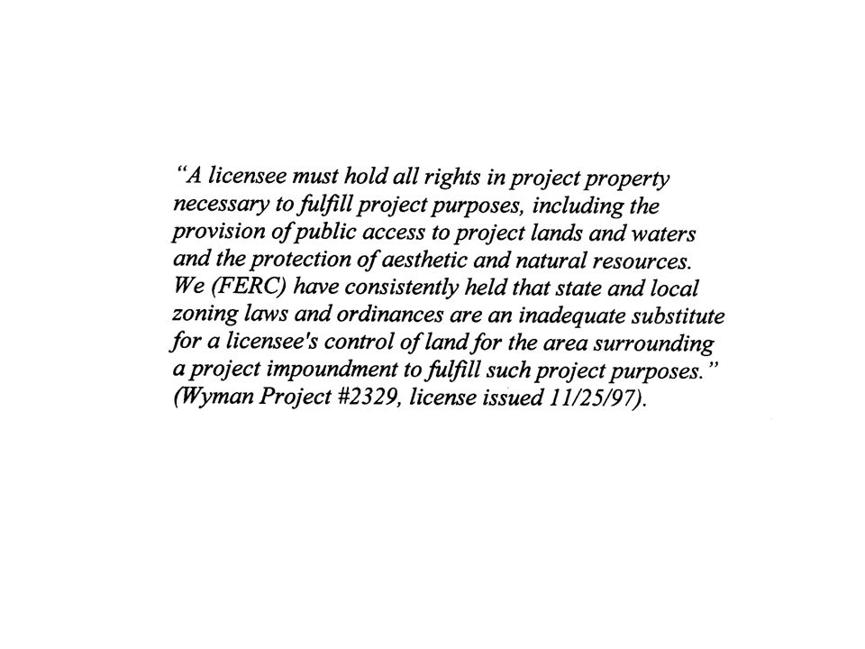
FERC will require justification for the overall location of the shoreline buffer zone from the intervenor(s). FERC applies a simplistic formula –up to 200 foot buffer zone, basis ?? Little evidence FERC accepts outright scientifically determined buffers

27
The strongest case one can make for the need of a protective shoreline buffer is to identify the location of specific water quality, ecological, aesthetic and/or recreational values. It is equally critical to quantify threats to these values. Describe, by actual location, where shoreline protection is essential for the protection of these resources over the tenure of the new license to be issued. If the resource is of local or regional significance, then make the case for protection. Is the land the last undeveloped major shoreline that provides a unique recreational and aesthetic opportunity, or harbors a critical wildlife habitat like a deer wintering yard? Is residential or second home development the threat? obtain the relevant zoning ordinances and calculate the theoretical residential or commercial build-out that could occur to demonstrate the magnitude of the development threat if the shoreline is not protected.

28
Laws, Regulations and License Articles Affecting Shoreline protection -- Federal Power Act --

29
Equal Consideration - Section 4(e) of the Federal Power Act requires FERC to give "equal consideration to the purposes of energy conservation, the protection, mitigation of damage to, and enhancement of, fish and wildlife (including related spawning grounds and habitat), the protection of recreational opportunities, and the preservation of other aspects of environmental quality." This is an important provision of the act with regards to land protection because it gives FERC the authority to include conditions in the license that set aside lands for recreational development, establish buffer zones along project shoreline, protect visual and aesthetic values of project lands, or protect lands for wildlife habitat. If the project is located on or within any federal reservation this section also gives authority to the responsible federal land management agency to file terms and conditions that protect the reservation to be included in the project license. Federal reservations include National Forests, National Parks, Land and Water Conservation Fund Act lands, National Trails, Wilderness Areas, National Wildlife Refuges, and other public lands.

30
Comprehensive Plan - Section 10(a) of the act specifies that a hydroelectric project can be developed by an individual or corporation, or an agency of a municipality or state provided it is "best adapted to a comprehensive plan for improving or developing a waterway or waterways for the use or benefit of interstate or foreign commerce, for the improvement and utilization of water power, for the adequate protection, mitigation, and enhancement of fish and wildlife…and for other beneficial public uses including irrigation, flood control, water supply, and recreational and other purposes…". FERC requires project applicants to identify all applicable comprehensive plans developed by state and federal agencies and determine if the project will comply with these plans (18 CFR 4.38). See section 3.1.d for examples of these plans.
. See section 3.1.d for examples of these plans..")
31
Comprehensive Plans of other federal, local, and state agencies that outline land protection needs, particularly if specific to the hydro project of concern, can justify land protection during relicensing. FERC currently lists over 800 comprehensive management plans from other agencies that meet their criteria for being considered during the licensing process (Revised List of Comprehensive Management Plans, April 2002) Examples: Wildlife Refuge Management plans USFS - Forest Management Plans Best management practices for timber harvesting National Marine Fisheries Service management plans State water quality plans for river and "beneficial use" designation State and regional river management plans
 Examples: Wildlife Refuge Management plans USFS - Forest Management Plans Best management practices for timber harvesting National Marine Fisheries Service management plans State water quality plans for river and beneficial use designation State and regional river management plans.")
32
Fish and Wildlife Agencies - Section 10(j) FERC has to address and then either accept or refute recommendations from these resource agencies relative to the protection, mitigation, and enhancement of fish and wildlife resources impacted by the project. Shoreline protection request adequately researched and presented by these resource agencies can be very effective at protecting lands. Request must specify the resources that would be protected by such actions, for example an adequate buffer to protect a heron rookery, bald eagle nesting site, or wetland. Section 10(j) is a potent tool, but only if properly executed.
 is a potent tool, but only if properly executed..")
33
Laws, Regulations and License Articles Affecting Shoreline protection -- FERC Regulations--

34
Lands for Recreation -18 CFR 2.7 This regulation states that: "reasonable expenditures by a licensee for public recreational development pursuant to an approved plan, including the purchase of land, will be included as part of the project cost… The Commission expects the licensee to assume the following responsibilities: (a) To acquire in fee and include within the project boundary enough land to assure optimum development of the recreational resources afforded by the project." It is not mandatory for FERC to require a Licensee to prepare a shoreline management plan or actually protect certain lands. But FERC has an obligation if the proper evidence exists.

35
“(2) Project boundary. The map must show a project boundary enclosing all of the principal project works and other features… The boundary must enclose only those lands necessary for operation and maintenance of the project and for other project purposes, such as recreation, shoreline control, or protection of environmental resources (see paragraph (f) of this section (Exhibit E)). Existing residential, commercial, or other structures may be included within the boundary only to the extent that underlying lands are needed for project purposes (e.g., for flowage, public recreation, shoreline control, or protection of environmental resources)…"
 of this section (Exhibit E)). Existing residential, commercial, or other structures may be included within the boundary only to the extent that underlying lands are needed for project purposes (e.g., for flowage, public recreation, shoreline control, or protection of environmental resources)… .")
36
Environmental Report - 18 CFR 4.51(f) Exhibit E must include descriptions of fish, wildlife, and botanical resources, historic and archeological resources, recreational resources and a report on land use. The report must also describe the impacts the project will have on these resources and any mitigation measures proposed. "A statement including an analysis of costs and other constraints, of the applicant's ability to provide a buffer zone around all or any part of the impoundment, for the purpose of ensuring public access to project lands and waters and protecting the recreational and aesthetic values of the impoundment and its shoreline" 18CFR4.51(f)(6)(iv).
(6)(iv)..")
37
Water Use and Quality: Do the project waters meet state water quality standards that apply to the project, and if not, do activities on reservoir shoreline either contribute to the problem directly or cumulatively? Would further development of the shoreline increase an existing water quality problem or create one? For example are low dissolved oxygen levels or eutrophication an identified water quality problem in the reservoir?

38
Wildlife and Botanical Resources: Does a thorough inventory of wildlife and botanical resources exist? Are there federal or state listed rare and threatened species or exemplary ecological communities thriving on these shorelines? Do current project boundaries and resource management plans actually provide long-term protection of the wildlife and botanical resources identified? If not, how should they be modified to protect these resources? Provide site-specific information on which and how much land should be protected.

39
Historical and Archeological Resources: Does the shoreline encompass Native American sites or other historical resources that development could threaten? Is a plan proposed to protect the required lands with an adequate buffer?

40
Geology and Soils: Do areas with existing or potential erosion or slope instability influenced by reservoir water level manipulations or discharges exist along the reservoir or in impacted downstream reaches? Would changes in land-use further increase the problem?

41
Recreation Resources: -Is an undeveloped shoreline one of the key regional amenities for recreational pursuits such as boating, canoeing, camping, hiking and other recreation? --How rare or threatened are undeveloped shorelines for recreation in the region? --Has an adequate case been presented for the value and increasing rarity of recreation on primarily undeveloped shorelines?

42
Visual Resources: Is one of the key visual and aesthetic values of the lands surrounding the project reservoirs the undeveloped shoreline? Is this resource identified and protected?

43
Land Use and Comprehensive Plans: -- Is there an accurate depiction of uses of land and resources adjacent to the project using maps, air photos that clearly delineates the land ownership, project boundary, and boundaries of public lands? --Is the Licensee presenting clearly what shoreline lands they may own through either direct or indirect subsidiary holdings that are not currently in project boundaries? --Has the Licensee not only identified relevant planning and zoning regulations to the shorelines, but also what the potential build out is under current zoning? --Has the Licensee included an accurate analysis of costs and other constraints, to provide a buffer zone around all or any part of the impoundment, for the purpose of ensuring public access to project lands and waters and protecting the recreational and aesthetic values of the impoundment and its shoreline? --Have they indicated that they cannot purchase additional shoreline to protect identified resources, when in reality their lands are held by another holding company within the same corporation?

45
‘The reservoir of concern is part of a nationally recognized multi-day backcountry canoe trip used extensively by the public (supporting documentation was provided). The Licensee should document the importance of this recreational resource and the role the impoundment’s undeveloped shoreline provides. Loss of access to the impoundment shoreline through development is the pivotal issue. The Licensee presents the case that the Maine Land Use Regulatory Commission’s (LURC) zoning regulations will protect the shoreline. LURC has provisions for the development of binding Lake Concept Plans developed voluntarily by the landowner (Maine's LURC Amendment of the Comprehensive Land Use Plan - Adopted June 7, 1990). The Licensee has not submitted such a plan. Our calculations (calculations attached)) show 348 new residences under LURC zoning could be built on the owner’s impoundment reservoir lands, and this does not include the fact that LURC Zoning could be changed during the course of the 30 year license to permit further development. This would essentially privatize the shoreline, making it inaccessible to the public, and deter from its unique backcountry recreation value. The Licensee’s lands on these reservoirs have been through 3 different owners in the last few years, so the possibility of sell off and development is more than theoretical. A recent Northern Forest Land Council Study (attachment) shows that the majority of subdivisions in the region occur on waterfront. Finally, the Licensee owns the land, therefore the cost of protecting these critical lands is not cost prohibitive.’
 zoning regulations will protect the shoreline. LURC has provisions for the development of binding Lake Concept Plans developed voluntarily by the landowner (Maine s LURC Amendment of the Comprehensive Land Use Plan - Adopted June 7, 1990). The Licensee has not submitted such a plan. Our calculations (calculations attached)) show 348 new residences under LURC zoning could be built on the owner’s impoundment reservoir lands, and this does not include the fact that LURC Zoning could be changed during the course of the 30 year license to permit further development. This would essentially privatize the shoreline, making it inaccessible to the public, and deter from its unique backcountry recreation value. The Licensee’s lands on these reservoirs have been through 3 different owners in the last few years, so the possibility of sell off and development is more than theoretical. A recent Northern Forest Land Council Study (attachment) shows that the majority of subdivisions in the region occur on waterfront. Finally, the Licensee owns the land, therefore the cost of protecting these critical lands is not cost prohibitive.’.")
46
In License Article –Pros and Cons transfer ownership? (e.g. Androscoggin Land Trust) New owner willing to have FERC involved? (e.g. East Outlet and State of ME, RLHT) On-site or off-site mitigation or enhancement (e.g. addition to Rangeley Lake State Park)
 New owner willing to have FERC involved. (e.g. East Outlet and State of ME, RLHT) On-site or off-site mitigation or enhancement (e.g. addition to Rangeley Lake State Park).")
47
"(a) In accordance with the provisions of this article, the licensee shall have the authority to grant permission for certain types of use and occupancy of project lands and waters and to convey certain interests in project lands and waters for certain types of use and occupancy, without prior Commission approval. The licensee may exercise the authority only if the proposed use and occupancy is consistent with the purposes of protecting and enhancing the scenic, recreational, and other environmental values of the project. For those purposes, the licensee shall also have continuing responsibility to supervise and control the use and occupancies for which it grants permission, and to monitor the use of, and ensure compliance with the covenants of the instrument of conveyance for, any interests that it has conveyed, under this article… “ (b) The type of use and occupancy of project lands and waters for which the licensee may grant permission without prior Commission approval are: (1) landscape plantings; (2) noncommercial piers, landings, boat docks, or similar structures and facilities that can accommodate no more than 10 watercraft at a time and where said facility is intended to serve single-family type dwellings; and (3) embankments, bulkheads, retaining walls, or similar structures for erosion control to protect the existing shoreline… “(c) The licensee may convey easements or rights-of-way across, or leases of, project lands for: (1) replacement, expansion, realignment, or maintenance of bridges and roads for which all necessary state and federal approvals have been obtained; (2) storm drains and water mains; (3) sewers that do not discharge into project waters; (4) minor access roads; (5) telephone, gas, and electric utility distribution lines; (6) non-project overhead electric transmission lines that do not require erection of support structures within the project boundary; (7) submarine, overhead, or underground major telephone distribution cables or major electric distribution lines (69 kV or less); and (8) water intake or pumping facilities that do not extract more than one million gallons per day from a project reservoir… “(d) The licensee may convey fee title to, easements or rights-of-way across, or leases of project l ands for: (1) construction of new bridges or roads for which all necessary state and federal approvals have been obtained; (2) sewer or effluent lines that discharge into project waters, for which all necessary federal and state water quality certification or permits have been obtained; (3) other pipelines that cross project lands or waters but do not discharge into project waters; (4) non-project overhead electric transmission lines that require erection of support structures within the project boundary, for which all necessary federal and state approvals have been obtained; (5) private or public marinas that can accommodate no more than 10 watercraft at a time and are located at least one-half mile from any other private or public marina; (6) recreational development consistent with an approved Exhibit R or approved report on recreational resources of an Exhibit E; and (7) other uses, if: (i) the amount of land conveyed for a particular use is five acres or less; (ii) all of the land conveyed is located at least 75 feet, measured horizontally, from the edge of the project reservoir at normal maximum surface elevation; and (iii) no more than 50 total acres of project lands for each project development are conveyed under this clause (d)(7) in any calendar year…”
 The type of use and occupancy of project lands and waters for which the licensee may grant permission without prior Commission approval are: (1) landscape plantings; (2) noncommercial piers, landings, boat docks, or similar structures and facilities that can accommodate no more than 10 watercraft at a time and where said facility is intended to serve single-family type dwellings; and (3) embankments, bulkheads, retaining walls, or similar structures for erosion control to protect the existing shoreline… (c) The licensee may convey easements or rights-of-way across, or leases of, project lands for: (1) replacement, expansion, realignment, or maintenance of bridges and roads for which all necessary state and federal approvals have been obtained; (2) storm drains and water mains; (3) sewers that do not discharge into project waters; (4) minor access roads; (5) telephone, gas, and electric utility distribution lines; (6) non-project overhead electric transmission lines that do not require erection of support structures within the project boundary; (7) submarine, overhead, or underground major telephone distribution cables or major electric distribution lines (69 kV or less); and (8) water intake or pumping facilities that do not extract more than one million gallons per day from a project reservoir… (d) The licensee may convey fee title to, easements or rights-of-way across, or leases of project l ands for: (1) construction of new bridges or roads for which all necessary state and federal approvals have been obtained; (2) sewer or effluent lines that discharge into project waters, for which all necessary federal and state water quality certification or permits have been obtained; (3) other pipelines that cross project lands or waters but do not discharge into project waters; (4) non-project overhead electric transmission lines that require erection of support structures within the project boundary, for which all necessary federal and state approvals have been obtained; (5) private or public marinas that can accommodate no more than 10 watercraft at a time and are located at least one-half mile from any other private or public marina; (6) recreational development consistent with an approved Exhibit R or approved report on recreational resources of an Exhibit E; and (7) other uses, if: (i) the amount of land conveyed for a particular use is five acres or less; (ii) all of the land conveyed is located at least 75 feet, measured horizontally, from the edge of the project reservoir at normal maximum surface elevation; and (iii) no more than 50 total acres of project lands for each project development are conveyed under this clause (d)(7) in any calendar year… .")
48
License Articles, Land ownership and Easements Easements – Who Holds? Term (length of License) or Permanent? Easement Endowment Fund? What's permitted?
 or Permanent. Easement Endowment Fund. What s permitted .")
Similar presentations


 Lack of detailed wetlands inventory information or guidance.>")


 –Administered by Coastal Programs Division of NOAA –Covers over 22% of U.S. Land Area –Multi-purpose.>")


