Download presentation
Presentation is loading. Please wait.

1
River Mapping for Endangered Species Habitat and Streambank Erosion Assessment: Case Studies at Fort Benning and Camp Atterbury Paul Ayers, Kelsey Hensley, Ken Swinson, Bryan McConkey, Brett Connell Biosystems Engineering, University of Tennessee Heidi Howard, ERDC - CERL Mike Peterkin, Natural Resources Coordinator Camp Atterbury JMTC Hugh Westbury, Watershed Program Manager, Fort Benning

2
Objectives Use canoe and kayak-mounted underwater videomapping system Develop aquatic habitat maps for the Driftwood River (20 miles) Develop optimum habitat maps for Rayed Bean (Villosa fabalis) mussel - PWTB 200-1-114 Snorkel and sneak peek mapping Streambank mapping (erosion) - Legacy Ocean/coral reef aquatic habitat maps
 Develop optimum habitat maps for Rayed Bean (Villosa fabalis) mussel - PWTB Snorkel and sneak peek mapping Streambank mapping (erosion) - Legacy Ocean/coral reef aquatic habitat maps")
4
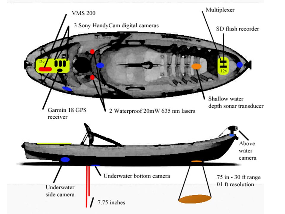
VIDEO CAMERAS LASERS SONAR TRANSDUCER WATERPROOF CASE

5
Geo-referenced Image Recording Audio Encoder Audio output (GPS output) Audio Input (GPS input) GPS Video input Splash Cam DVD Recorder GPS NMEA Data (ASCII)
 Audio Input (GPS input) GPS Video input Splash Cam DVD Recorder GPS NMEA Data (ASCII)")
7
Canoeing with Drop-down Camera

8
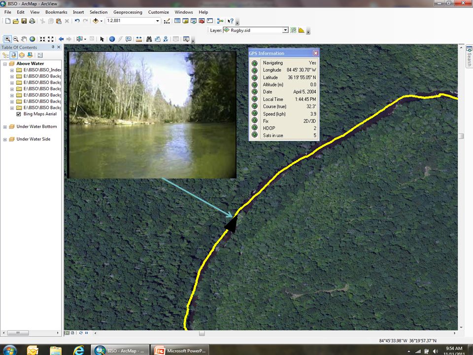
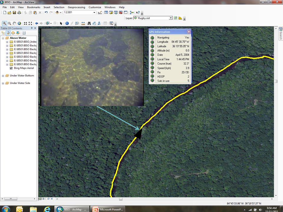
Georeferenced Above Water Image

9
GIS Attributes Defined GPS Position Depth Width Substrate River Characteristic Embeddedness Streambank Erosion (bank height, bank angle, riparian diversity, river sinuosity)
")
10
Modified Wentworth Scale SubstrateDescription BedrockUnbroken Rock Surface Fines/Sand< 0.3 cm (0.1 inch) Small Gravel0.3—1.0 cm (0.1—0.4 inch) Large Gravel1.0—10 cm (0.4—4 inch) Cobble10—30 cm (4—12 inch) Small Boulder30—60 cm (12—24 inch) Large Boulder> 60 cm (24 inch)
 Small Gravel0.3—1.0 cm (0.1—0.4 inch) Large Gravel1.0—10 cm (0.4—4 inch) Cobble10—30 cm (4—12 inch) Small Boulder30—60 cm (12—24 inch) Large Boulder> 60 cm (24 inch)")
11
Using underwater lasers to determine Substrate scale (dot spacing is 7.75 inches)
")
12
Substrate Classification

13
Sand Small Gravel Cobble Small BoulderLarge BoulderBedrock Some Substrate Types

14
River Surface Characteristics

15
Driftwood River River Characteristics 20 mile 38,503 Sample Points

16
Driftwood River Thalweg Depth 20 mile 38,053 Sample Points

17
Driftwood River Substrate 20 mile 38,053 Sample Points

18
Species at Risk Habitat Maps Rayed Bean (Villosa fabalis) mussel Develop Optimum Habitat Criteria
 mussel Develop Optimum Habitat Criteria")
19
Rayed Bean (Villosa fabalis) Habitat Criteria primarily found in small, shallow rivers usually about 4 feet in depth or less in and near riffles/runs usually found deeply buried in sand and gravel substrates often in and around aquatic vegetation Search (Depth <= 4 feet) River Characteristic = riffle/run Substrate = sand or gravel
 Habitat Criteria primarily found in small, shallow rivers usually about 4 feet in depth or less in and near riffles/runs usually found deeply buried in sand and gravel substrates often in and around aquatic vegetation Search (Depth <= 4 feet) River Characteristic = riffle/run Substrate = sand or gravel")
20
Rayed Bean (Villosa fabalis) 6.7% Optimum Habitat
 6.7% Optimum Habitat")
21
Obed Wild and Scenic River

23
Virtual tour capabilities

27
Summary - River Habitat Videomapping for Aquatic Species at Risk (SAR) Habitat Cover large reaches (10 miles/day) - continuous Non-intrusive, no access required Determine above and below water features Develop total river habitat suitability index By mapping every foot of the river, the total amount and location of optimum habitat can be determined (development occupancy model) Provides permanent historical video database to evaluate changing habitat conditions
 Habitat Cover large reaches (10 miles/day) - continuous Non-intrusive, no access required Determine above and below water features Develop total river habitat suitability index By mapping every foot of the river, the total amount and location of optimum habitat can be determined (development occupancy model) Provides permanent historical video database to evaluate changing habitat conditions")
28
Legacy FY 2015 Proposal Species At-Risk, Species of Concern and Declining Species and Habitat (Natural) Pilot or demonstration efforts of new techniques, methodologies, and management practices, including the implementation of new or innovative monitoring and predictive modeling techniques. Ken Oristaglio – Fort Picket (Nottoway River) –Roanoke Logperch –Atlantic Pigtoe Others?
 –Roanoke Logperch –Atlantic Pigtoe Others .")
31
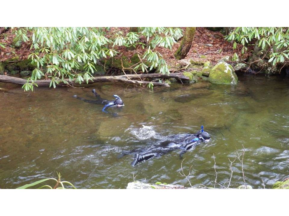
Snorkel mapping for Species counts Embedded video recorder and GPS on back strap

35
Georeferenced manual underwater recording video for observing under rocks

38
Legacy Project (Year 1) GIS-based streambank mapping to identify areas of erosion potential on rivers/streams within military installations (Camp Atterbury and Fort Benning) Mapping Site-specific Streambank Erosion
 GIS-based streambank mapping to identify areas of erosion potential on rivers/streams within military installations (Camp Atterbury and Fort Benning) Mapping Site-specific Streambank Erosion")
39
Streambank Erosion Videomapping Determine erodibility and erosivity Identify areas of restoration needs Cover large areas (10 miles/day) - continuous Non-intrusive, no access required Permanent video database and virtual tour capability Uses EPA Bank Assessment of Non-point source Consequences of Sediment (BANCS) for annual total streambank erosion prediction Used to determine sediment TMDL’s.
 - continuous Non-intrusive, no access required Permanent video database and virtual tour capability Uses EPA Bank Assessment of Non-point source Consequences of Sediment (BANCS) for annual total streambank erosion prediction Used to determine sediment TMDL’s.")
41
THE END -Questions? Paul Ayers, University of Tennessee - ayers@utk.eduayers@utk.edu

Similar presentations


 FUNCTIONAL STREAM ASSESSMENT Facilitated by LRL HGM Team: Jennifer.>")


 Stream Channel Pattern Substrate Chemical Properties pH Dissolved Oxygen Temperature Nutrients Turbidity.>")

>")


>")