Download presentation
Presentation is loading. Please wait.

1
Innovative methods for tropical cyclone genesis/track prediction T. N. Venkatesh Flosolver Unit National Aerospace Laboratories Bangalore, INDIA tnv@flosolver.nal.res.in

2
Outline Introduction: Flosolver Lab Problem of Tropical cyclone (TC) genesis/track prediction TC genesis –Vortex merger theory –Prediction method TC track –Effect of new boundary layer Conclusion
 genesis/track prediction TC genesis –Vortex merger theory –Prediction method TC track –Effect of new boundary layer Conclusion")
3
Flosolver Lab 1980’s – denial regime – in-house ``supercomputer’’ development India’s first parallel computer in 1986 Six generations

4
Flosolver Lab NAL / Flosolver : parallel computer for fluid dynamics Atmospheric modelling for nearly two decades TC genesis : PhD problem Track simulations : part of NMITLI project

5
Tropical cyclones Of both scientific and practical interest –Track, intensity prediction –Genesis –Storm surge Accurate track forecasts have considerable societal value. Genesis prediction, could help in advanced warning

6
TC Genesis: Gray’s conditions Warm sea waters ( > 27 degrees) Weak vertical shear of wind Latitude greater than 5 degrees Conditions suitable for moist convection Necessary but not sufficient What is the critical factor ?
 Weak vertical shear of wind Latitude greater than 5 degrees Conditions suitable for moist convection Necessary but not sufficient What is the critical factor")
7
Earlier theories : CISK Conditional Instability of the Second Kind Charney 1964 Growth at realistic length and time scales Short wavelength cutoff Energy source

8
Earlier theories : WISHE Air – Sea interaction Emanuel, 1986 Integral view of moisture/heating Finite amplitude nature Energy source

9
Vortex merger theory (PhD Thesis: T. N. Venkatesh, IISc, April 2003) Stage 1: Mid -level mesoscale vortices interact. If this interaction results in merger, the second stage is reached Stage 2: This larger vortex increases in strength due to the air- sea interaction mechanism
 Stage 1: Mid -level mesoscale vortices interact. If this interaction results in merger, the second stage is reached Stage 2: This larger vortex increases in strength due to the air- sea interaction mechanism.")
10
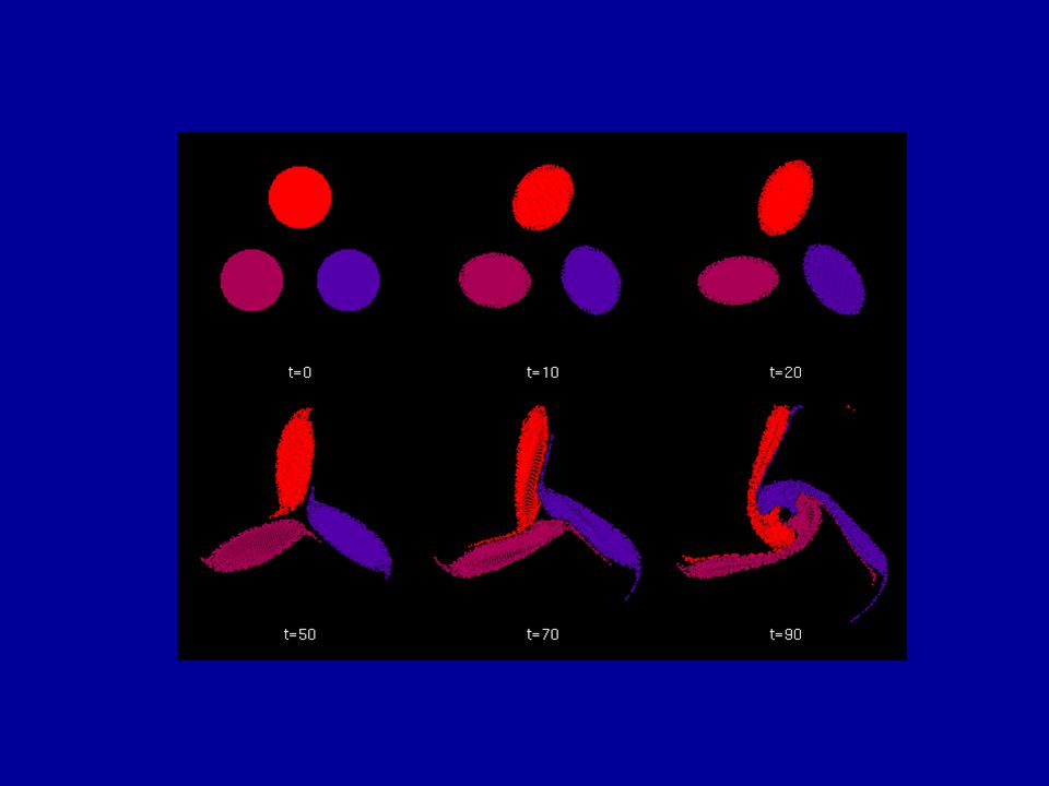
Numerical simulations Stage 1: 2 D vortex patch studies Critical distance for merger of regular configurations of vortex patches These occur at length and time scales relevant to atmospheric vortices Vortex blob method of Beale and Majda Also : Second order moment model of Melander etal

11
Two patches

12
Critical distance ~ 3.2

13
Three patches

15
Four patches

17
Critical distance for merger

18
Stage 2 Axisymmetric model – Clouds – Boundary layer –... Mid-level vortices decay, but a deep vortex which extends down to the boundary layer amplifies

19
Observational Evidence from IR Images Merger of MCVs prior to TC formation using satellite images and observed wind fields 23 October 1999 28 October 1999 Also, evidence exists from aircraft observations in the Pacific: Ritchie et al and Simpson et al

20
Prediction method R_cg : Average distance of the systems from centroid L : Average radius of the systems r*(n) : Critical radius of merger Prediction : True test of a theory Identify MCVs, integrate Simpler approach : Merger index
 : Critical radius of merger Prediction : True test of a theory Identify MCVs, integrate Simpler approach : Merger index")
21
Vortex merger index Calculated from satellite IR images –From the CIMSS website (3 hour intervals) Studies in the Bay of Bengal Real-time tests since October 2002 Can give advance warning for formation by about 48 hours – Geophysical Research Letters, Vol 31, L04105, February 2004 Four seasons : Eight events –6 lead to TC formation –2 False alarms (depressions formed)
 Studies in the Bay of Bengal Real-time tests since October 2002 Can give advance warning for formation by about 48 hours – Geophysical Research Letters, Vol 31, L04105, February 2004 Four seasons : Eight events –6 lead to TC formation –2 False alarms (depressions formed)")
22
The merger index

23
Test cases

24
Recent seasons False alarm More analysis required

25
Possible use of additional data from Megha-Tropiques Mesoscale structures (MCSs, MCVs) –Validate theory Earlier detection of MCS/MCVs Velocity fields ?
 –Validate theory Earlier detection of MCS/MCVs Velocity fields")
26
Track prediction

27
NMITLI project on “Mesoscale modelling for monsoon related predictions” NAL, IISc, TIFR team – Option A software Development of a new prediction code to be run efficiently on NMITLI hardware Reengineered NCMRF T-80 code forms the backbone for the present model: –Written in Fortran 90 –New boundary layer module –New radiation module –Grid clustering

28
NMITLI Code – Version 1 Operational on Flosolver MK6 Rewritten in Fortran 90 Seed code: NCMRWF/NCEP GCM T-80 Incorporates new physics modules Boundary layer Radiation Engineered software Code length reduced Nanjundiah & Sinha, Current Science, 1999

29
New boundary layer scaling at low winds Tropics characterized by convection at low winds Monin-Obukhov not applicable Usual fix: Gustiness parameter ( Hack et al, 1993 ) New parameterization in NMITLI code for weakly forced convection “Heat-flux scaling for weakly forced turbulent convection in the atmosphere” K. G. Rao and R. Narasimha, JFM 2005 Based on data from MONTBLEX-90 (Narasimha, Sikka and Prabhu 1997) and BLX-83 (Stull 1994)
 and BLX-83 (Stull 1994).")
30
Weakly forced convection MONTBLEX-90 (Jodhpur, India) Drag is linear in wind speed BLX-83 (Chickasha, USA)
 Drag is linear in wind speed BLX-83 (Chickasha, USA)")
31
Weakly forced convection Heat flux given by free convection MONTBLEX-90 (Jodhpur, India) BLX-83 (Chickasha, USA)
 BLX-83 (Chickasha, USA)")
32
Implementation of new parameterization Weakly forced convection Drag is a linear function of wind speed Heat flux is independent of wind speed Define matching velocity -V m V > V m use M-O estimates V < V m use Heat flux scaling Match at V m Integrated into the NMITLI GCM and tested Values of V m : 1, 3, 5 m/s

33
Low resolution : 80 Modes :Old BL Observed Simulated

34
Low resolution : 80 Modes: New BL V m = 5 m/s Observed Simulated

35
Higher resolution :120 Modes: Old BL Grid : 512x256 Observed Simulated

36
Higher resolution:120 Modes: New BL V m = 3 m/s Grid : 512x256 Observed Simulated

37
V m = 5 m/s Grid : 512x256 Observed Simulated Higher resolution:120 Modes: New BL

38
Orissa Supercyclone 1999 Track errors

39
Track improvement : Preliminary analysis Surface force on the TC due to the PBL computed –Within a radius of 8 grid lengths (approximately 640 km) from centre of TC Total torque
 from centre of TC Total torque")
40
Preliminary analysis: Stress fields

41
Surface force on TC

42
Possible use of additional data from Megha-Tropiques Surface fluxes –Heat –Moisture Accurate fixing of the Initial position of the Tropical Cyclone

43
Concluding remarks Tropical Cyclone genesis –New prediction method –Results are encouraging –Further work is necessary Tropical Cyclone track –Use of a new boundary layer scaling improves track simulation significantly Additional data from the Megha-Tropiques satellite would help in refining these schemes

49
Cyclone 03B, 2003 Track errors

50
Radiation Module Long wave - new code based on work of Varghese etal Valid from surface to 100 km Accurate near the surface Integrated into NMITLI Code Version 1 CPU time Being optimized Look up table Varghese, A. V. Murthy and R. Narasimha, JAS 2003

Similar presentations


 Kristen L. Corbosiero, Wei Wang, Yongsheng Chen, Jimy Dudhia.>")

 to Planetary Boundary Layer Parameterizations SCOTT A. BRAUN AND WEI-KUO TAO PRESENTATION.>")
 Associated With the ITCZ Breakdowns The UMD/NASA-GSFC Users' and Developers' Workshop,>")

 Chia-chi Wang Dept. Atmospheric Sciences Chinese Culture University Acknowledgment: Prof.>")
 and recent lack of ENSO related cold-tongue warming D.E. Harrison and A.M. Chiodi (presenting)>")


 Zhan Li and Zhaoxia Pu.>")


 Prediction System Next generation non-hydrostatic weather research and hurricane prediction system.>")

