Download presentation
Presentation is loading. Please wait.

1
A Rapid Assessment of Sediment Delivery from Clearcut Timber Harvest Activities in the Battle Creek Watershed, Shasta and Tehama Counties, California

2
SPI uses extensive clearcut harvesting Concerned environmental stakeholders in the watershed (Sacramento Bee, 2011)
")
3
Article implied clearcutting is causing water quality impacts to Battle Creek Is the permitting of clearcutting running counter to goals and objectives of Restoration Project? (Sacramento Bee, 2011)
.")
4
Battle Creek Task Force Formed Task Force staffed by two members from following THP Review Team agencies: –Central Valley Regional Water Quality Control Board; –California Department of Fish and Game; –California Geological Survey; and –CAL FIRE. Subject matter experts with decades of combined field experience in forestry-water- fish issues

5
Purpose Statement: Evaluate whether timber operation associated with SPI clearcut harvesting in Battle Creek has resulted in observable erosion and subsequent delivery of sediment which has resulted in violation of state law or observable negative impacts to fisheries.

6
Background

7
Water Quality Impacts From Timber Harvest A Function Of: Proximity of activity to stream Erosion potential of activity

8
Proximity of Erosion Source to Stream (Croke and Hairsine, 2006)
")
9
Erosion Potential of Activity Gully Erosion to a Class III watercourse

10
Soil Compaction

11
Surface Cover Removal Very Little Erosion Anything Can Happen High Risk (Larsen and others, 2009)
")
12
Flowpath Modification (R. Ettner, Siskiyou National Forest)
")
13
Soil/Earth Movement

14
Potential Impacts from Overstory Removal Discharge Time Pre- Clearcut Post- Clearcut (Jones and Grant, 1996)
")
15
Site Selection – Clearcuts Adjacent to Watercourses

16
Site Selection - Road Crossings

17
Site Selection – Watercourse- Adjacent Road Segments

18
Site Selection - Tractor Crossings

19
Site Selection – Watercourse- Adjacent Landings

20
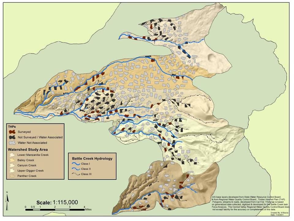
Site Selection Placed highest priority on clearcuts with buffers on fish-bearing streams (Class I WLPZs); Other prioritization criteria: –Time since operation (at least one season of overwintering) –Tractor logging –Steeper slopes –More erodible soils (e.g., rhyolite-derived soils)
; Other prioritization criteria: –Time since operation (at least one season of overwintering) –Tractor logging –Steeper slopes –More erodible soils (e.g., rhyolite-derived soils)")
22
Methods Walk the interface between clearcut and riparian buffer to look for sediment delivery (Litschert and MacDonald, 2009); Visit pre-identified road crossings, tractor crossings, and landings; Walk watercourse-adjacent road segments.
; Visit pre-identified road crossings, tractor crossings, and landings; Walk watercourse-adjacent road segments.")
23
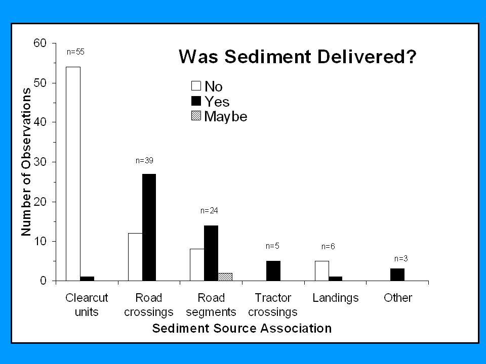
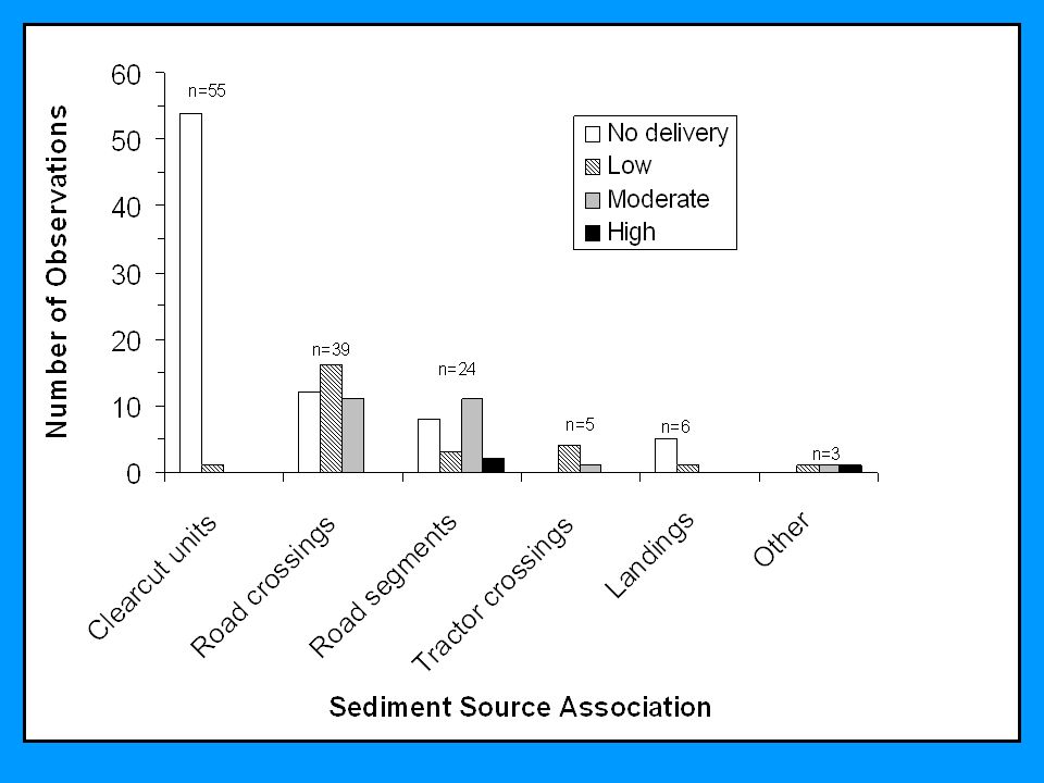
Methods Identify if sediment was delivered to watercourse; Evaluate relative magnitude of sediment delivery: –Low (< 1 yd 3 ) –Moderate (1 to 10 yd 3 ) –High (> 10 yd 3 ) Characterize erosion; Identify erosion source.
 –Moderate (1 to 10 yd 3 ) –High (> 10 yd 3 ) Characterize erosion; Identify erosion source.")
30
Watercourse Classification Total Length of Buffer (miles) Length of Buffer Assessed (miles) Percent Assessed Class I7.76.888 Class II5.11.733 Class III21.67.635 Total:34.416.147
 Length of Buffer Assessed (miles) Percent Assessed Class I Class II Class III Total:")
32
Road Crossings

33
Sediment delivery generally came from crossing approaches Privately-maintained road behind gates generally delivered little sediment Publicly-maintained roads and roads with public access had higher likelihood of delivering moderate magnitudes of sediment

36
Watercourse-Adjacent Road Segments

37
Segments most likely to deliver when they were within 30 feet of watercourse Roads with moderate to high magnitudes of sediment delivery were within 5 to 20 feet Sediment delivery often unmitigatible

39
Tractor Crossings and Landings All tractor crossings deliver at least a low magnitude of sediment –Difficult to return channel to pre-logging condition –Delivery limited by general lack of tractor crossings Landings generally delivered no sediment due to ample surface cover provided by chipping operations

40
Why No Sediment Delivery from Clearcuts?

41
BMPs Effective in Preventing Direct Sediment Delivery from Clearcuts Strategic skidding and effective drainage (waterbars) limits runoff production and erosion; Contour ripping decreases compaction, increases infiltration, and decreases slope length; Surface cover remains relatively high (typically greater than 75%); Sediment-laden runoff routed to areas relatively undisturbed by heavy machinery; Buffer strips effective at infiltrating runoff and filtering sediment.
 limits runoff production and erosion; Contour ripping decreases compaction, increases infiltration, and decreases slope length; Surface cover remains relatively high (typically greater than 75%); Sediment-laden runoff routed to areas relatively undisturbed by heavy machinery; Buffer strips effective at infiltrating runoff and filtering sediment.")
42
Is This An Anomaly? Litschert and MacDonald (2009) assessed 180 miles of stream buffer adjacent to timber harvest units, including clearcuts, in Sierra Nevada and Southern Cascades; Found only 6 erosion features that delivered to watercourses.
 assessed 180 miles of stream buffer adjacent to timber harvest units, including clearcuts, in Sierra Nevada and Southern Cascades; Found only 6 erosion features that delivered to watercourses..")
43
Linkage to Fish Habitat Clearcuts not causing observable negative impacts to fisheries habitat Roads may be causing chronic sedimentation –Further study and monitoring needed

44
Assessment Limitations Unable to look at indirect impacts of clearcutting: –Clearcutting can increase peak-flow magnitude and duration, potentially resulting in: Increases in suspended sediment and turbidity Channel changes – increased bank erosion and/or gully erosion

45
Assessment Limitations Depends on forensic evidence available in field: –Erosion features can be transient –Erosion features can be modified by subsequent management –Assessment area not subject to stressing storm events during recent harvest activity Time frame coincides with turbidity data collected by BCA

46
Conclusions (1) No significant direct water quality impacts related specifically to harvest within clearcuts units Most sediment delivery comes from road crossings and watercourse-adjacent road segments –Higher magnitudes came from publicly- accessed road (e.g., county roads, ungated roads)
 No significant direct water quality impacts related specifically to harvest within clearcuts units Most sediment delivery comes from road crossings and watercourse-adjacent road segments –Higher magnitudes came from publicly- accessed road (e.g., county roads, ungated roads)")
47
Conclusions (2) Violations of Forest Practice Rules occurred but generally rare and appeared to be of relatively minor significance to salmonids Did not assess indirect water quality impacts from clearcuts –Water quality impacts due to logging-induced changes in hydrology remains an open question in young volcanic terranes such as the Battle Creek watershed
 Violations of Forest Practice Rules occurred but generally rare and appeared to be of relatively minor significance to salmonids Did not assess indirect water quality impacts from clearcuts –Water quality impacts due to logging-induced changes in hydrology remains an open question in young volcanic terranes such as the Battle Creek watershed")
48
Questions? (http://www.battle-creek.net/)

49
Culvert Initiated Gully Delivering Sediment to the SF Battle Creek - Ponderosa Way

52
Recommendation #1 Maintain current emphasis on field review of road crossings, watercourse-adjacent road segments, tractor crossings, landings, and management activities in the WLPZ. More emphasis on interagency completion inspections to evaluate adequacy and effectiveness of road-related BMPs.

53
Recommendation #2 Encourage landowners in the watershed to develop road management plans for the roads on their property and/or roads they control. Encourage development of a watershed- wide road inventory to identify and prioritize the treatment of road-related sediment sources -

54
Recommendation #3 Focus on the hydrological disconnection of privately-maintained and publicly- maintained roads Training that highlights how to strategically place waterbreaks (rolling dips) to minimize sediment delivery Consider access limitations on sensitive road segments during the rainy season to limit damage of erosion control facilities
 to minimize sediment delivery Consider access limitations on sensitive road segments during the rainy season to limit damage of erosion control facilities")
55
Recommendation #4 Evaluate the need to treat road surfaces that drain to watercourses Focus treatment on roads most likely to deliver sediment –Crossing approaches that cannot be disconnected –Roads within ≈ 30-50 feet of stream

56
Recommendation #5 Road managers should evaluate the need to abandon and/or relocate watercourse- adjacent roads –Target roads within 30 to 50 feet of watercourses

57
Recommendation #6 Support passage of a comprehensive “Road Rules Package” by the Board of Forestry and Fire Protection. –Draft version requires implementation of Recommendations 2 and 3 of this report

58
Recommendation #7 Coordinate with counties to develop programs that focus on fish-friendly BMP implementation for county road systems Central Valley Water Board will explore regulatory mechanisms to help achieve water quality objectives on county roads

59
Recommendation #8 Provide a road and road crossing BMP component for Licensed Timber Operator (LTO) training
 training")
60
Recommendation #9 Encourage outreach workshops for LTOs, local landowners, and county public works supervisors and equipment operators to inform them of state-of-the-art-road- related-BMPs

61
Recommendation #10 Engage in follow-up study to relate results of the assessment to water column data (turbidity) and in-channel physical habitat characteristics. –Follow-up study should also address the potential for timber harvest associated peak- flow induced increases to suspended sediment, turbidity, bedload transport, and/or channel alterations.

Similar presentations


 Regulations Fulton County Conservation District 216 N. Second Street, Suite 15.>")


