Download presentation
Presentation is loading. Please wait.

1
Rerport on the use geographical information in the Statistical Office Slovak Republic October, 2001 Zuzana Podmanická, Ivan Masaryk

2
The State Information System. The State Information System GI strategy GI infrastructure

3
The State Information System. The state information system is a set of information entities and information activities that secures the fulfilment of the functions of the state. Information entities and information activities are parts of the state information system, insofar as they are financed by the state budget of the Slovak Republic.

4
Bodies Acting in the Area of the State Information System SIS Council of the Goverment for Information Technology Ministry of Education of the Slovak Republic Central bodies of state administration Office of the National Council Office of the President MinistriesEtc. Statistical Office Geodesy, Cartography and the Cadastre Authority...

5
Geodesy, Cartography and the Cadastre Authority of the Slovak Republic Automated Information System of Geodesy, Cartography and Cadastre Geodetic Control Information System of Cadastre Primary database for GIS source: Geodesy, Cartography and the Cadastre Authority

6
Primary database for GIS ¯The vector data base with the level of detail corresponding to the Basic map of the Slovak Republic 1 : 50 000 ¯The vector data base with the level of detail corresponding to the Basic map of the Slovak Republic 1 : 200 000 ¯The vector data base with the level of detail corresponding to the Map of the administrative division of the Slovak Republic 1 : 400 000 ¯The raster data base with the level of detail corresponding to the Administrative map of the Slovak Republic 1 : 250 000

7
Primary database for GIS Specimen: The Basic Map of the Slovak Republic 1:50 000 source: Geodesy, Cartography and the Cadastre Authority

8
Primary database for GIS Specimen: Administrative Map of the Slovak Republic 1:400 000 source: Geodesy, Cartography and the Cadastre Authority

9
Cooperation Statistical Office cooperates mainly with: Geodesy, Cartography and the Cadastre Authority of the Slovak Republic the Ministry of Interior of the Slovak Republic the Ministry of the Environment of the Slovak Republic

10
Statistical Office of the Slovak Republic BRATISLAVA SO SR Primary tasks GI

11
Codification Code: SK

12
Codification Code: SK01, SK02, SK03, SK04

13
Codification Code: SK01 (1), SK021, SK022, SK023, SK031, SK032, SK041, SK042
, SK021, SK022, SK023, SK031, SK032, SK041, SK042")
14
Codification In the Slovak Republic there are 79 districts. Nomenclature of districts is formed by three digit code with the region number as the first one.

15
Codification In the Slovak Republic there are 2883 municipalities. Nomenclature of municipalities of the Slovak Republic is formed by identification numbers within interval 50001 - 59999.

16
Data files Automated Statistical Information System Automated Statistical Information System (ASIS) is a part of the State Information System, and it has been built according to conception SO SR
 is a part of the State Information System, and it has been built according to conception SO SR")
17
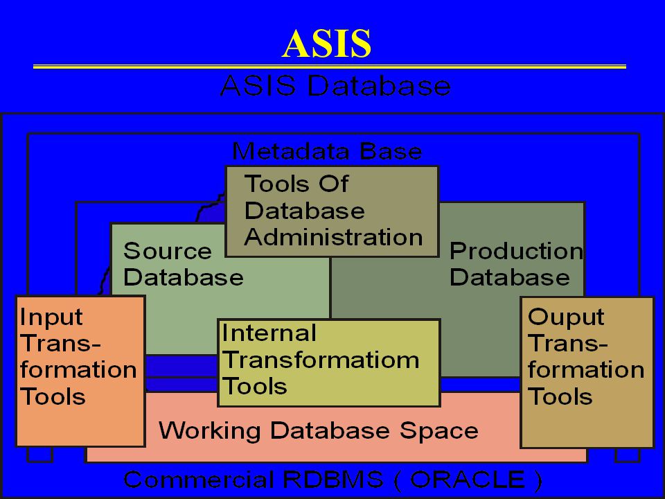
ASIS

19
Data files ASIS Regional database Database UMS/UIS PERSPECTIVE ASIS

20
The use of GIS Current situation So far GIS was used by the SO SR in the field of population statistics the regional statistics election statistics

21
The use of GIS Specimens Census 1991 20% is licit limit for administration

22
The use of GIS Specimen Census 2001

23
The use of GIS Specimen Demography

24
The use of GIS Specimen Demography

25
The use of GIS Specimen Demography

26
The use of GIS Specimen Regional statistics

27
The use of GIS Specimen Election statistics

28
The use of GIS Specimen Election statistics

29
The use of GIS Specimen Election statistics

30
GIS perspective The main short term aims are as follows: »development, management and upgrading of databases »software »GIS outputs quality »education »publications »Intra/Internet presentations

31
Thank you for your attention www.statistics.sk www.geodesy.gov.sk

Similar presentations


Status of use of GIS in production and dissemination of statistics – creation of thematic maps, yearbooks. b)Rules for handling confidentiality – under.>")


