Download presentation
Presentation is loading. Please wait.

2
What is Rural? Steven Hirsch Department of Health and Human Services Health Resources and Services Administration Office of Rural Health Policy

3
Who Defines Rural? The Census Bureau The Office of Management and Budget (OMB) United States Department of Agriculture’s Economic Research Service (ERS) Office of Rural Health Policy (ORHP)
 United States Department of Agriculture’s Economic Research Service (ERS) Office of Rural Health Policy (ORHP).")
4
The Census Bureau The Census Bureau identifies two types of urban areas: Urbanized Areas (UAs) of 50,000 or more people; Urban Clusters (UCs) of at least 2,500 and less than 50,000 people.
 of 50,000 or more people; Urban Clusters (UCs) of at least 2,500 and less than 50,000 people.")
5
The Census Bureau For the 2010 Census, an urban area will comprise a densely settled core of census tracts and/or census blocks that meet minimum population density requirements, along with adjacent territory containing non-residential urban land uses as well as territory with low population density included to link outlying densely settled territory with the densely settled core. To qualify as an urban area, the territory identified according to criteria must encompass at least 2,500 people, at least 1,500 of which reside outside institutional group quarters.

6
Urban/Rural Population AreaPopulationPercentage of Population 2010200020102000 United States308.7 million281.4 million Urban249.2 million222.3 million80.7%79% Urbanized Areas 219.9 million192.3 million71.2%68.3% Urban Clusters 29.3 million30 million9.5%10.7% Rural59.5 million59 million19.3%21%

16
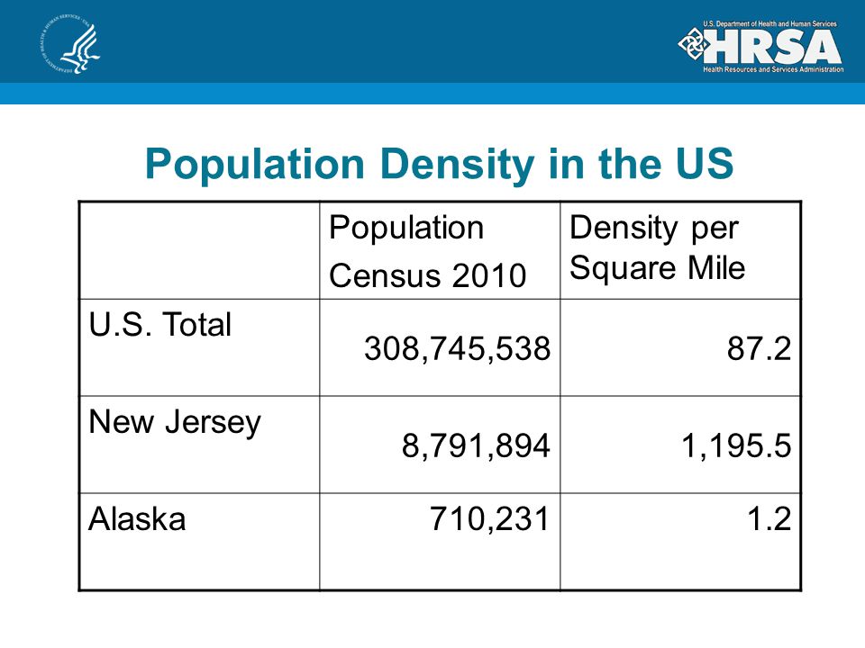
Population Density in the US Population Census 2010 Density per Square Mile U.S. Total 308,745,53887.2 New Jersey 8,791,8941,195.5 Alaska710,2311.2

17
Population Density in Urban Areas Population Census 2010 Density per Square Mile U.S. Total 308,745,53887.2 U.S. Urban Areas 249,253,2712,534.4 The Netherlands 16,730,6321,276.7

19
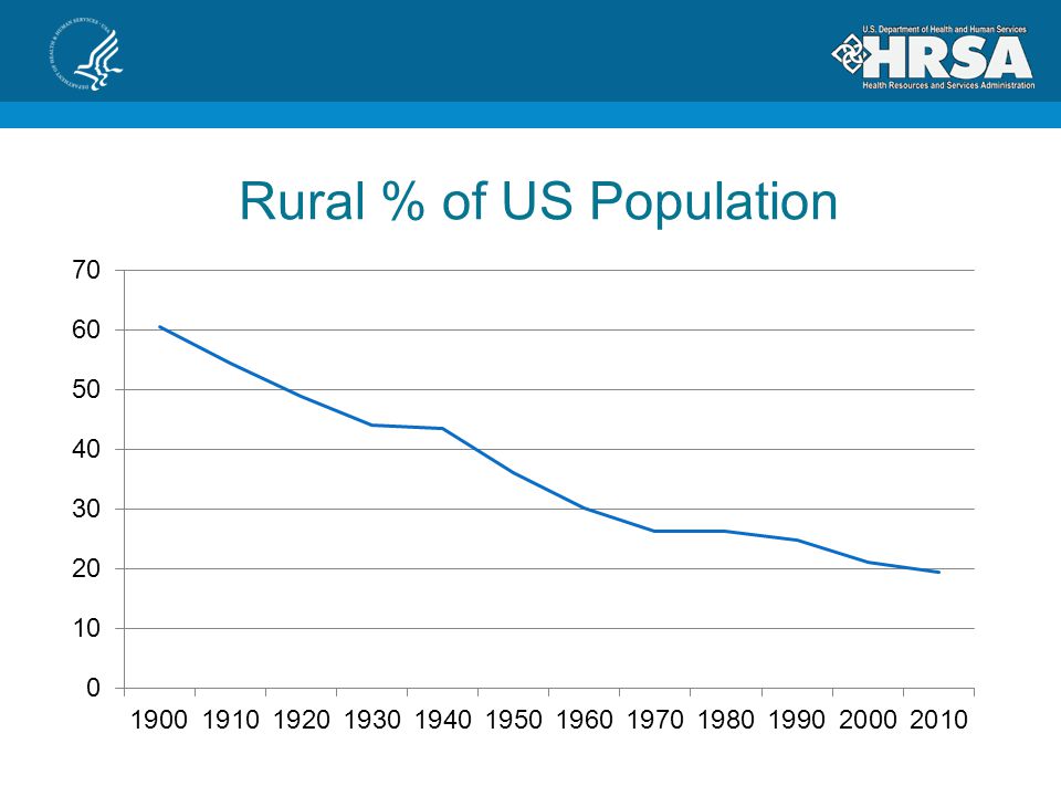
Rural % of US Population

20
Rural US Population

21
Howard County, Maryland

22
OMB OMB defines Metropolitan and Micropolitan Statistical Areas Metro Areas contain a core urban area of 50,000 or more population Micro Areas contains an urban core of at least 10,000 (but less than 50,000) population. Known as Core Based Statistical Areas (CBSAs)
.")
23
OMB Each metro or micro area consists of one or more counties and includes the counties containing the core urban area, as well as any adjacent counties that have a high degree of social and economic integration (as measured by commuting to work) with the urban core.
 with the urban core.")
27
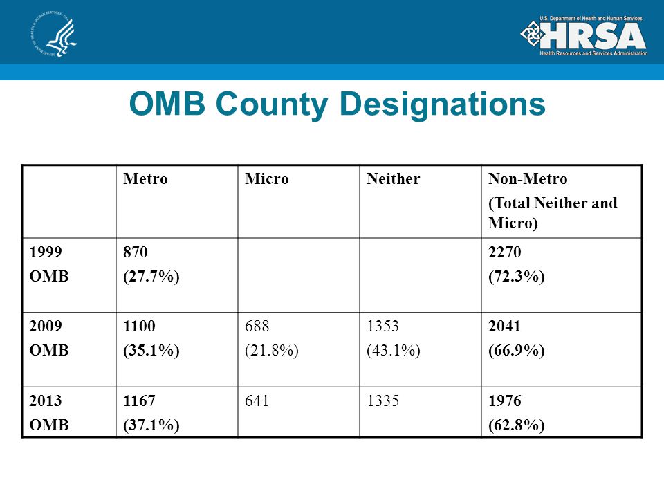
OMB County Designations MetroMicroNeitherNon-Metro (Total Neither and Micro) 1999 OMB 870 (27.7%) 2270 (72.3%) 2009 OMB 1100 (35.1%) 688 (21.8%) 1353 (43.1%) 2041 (66.9%) 2013 OMB 1167 (37.1%) 64113351976 (62.8%)
 1999 OMB 870 (27.7%) 2270 (72.3%) 2009 OMB 1100 (35.1%) 688 (21.8%) 1353 (43.1%) 2041 (66.9%) 2013 OMB 1167 (37.1%) (62.8%)")
28
Population (%) (2009 OMB) Population (%) (2013 OMB) Metro258,317,763 (83.7) 262,452,132 Micro 30,943,552 (10) 27,154,213 Neither19,484,223 (6.3) 19,139,193 Total Nonmetro 50,427,775 (16.3)46,293,406 OMB Counties, 2010 Census
 (2009 OMB) Population (%) (2013 OMB) Metro258,317,763 (83.7) 262,452,132 Micro 30,943,552 (10) 27,154,213 Neither19,484,223 (6.3) 19,139,193 Total Nonmetro 50,427,775 (16.3)46,293,406 OMB Counties, 2010 Census")
29
Metro Counties in Maryland

30
OMB Counties, 2010 Census Population (%) (2009 OMB) Population (%) (2013 OMB) Metro258,317,763 (83.7)262,452,132 (85) Micro30,943,552 (10)27,154,213 (8.8) Neither19,484,223 (6.3)19,139,193 (6.2) Total Non-metro 50,427,775 (16.3)46,293,406 (15)
 (2009 OMB) Population (%) (2013 OMB) Metro258,317,763 (83.7)262,452,132 (85) Micro30,943,552 (10)27,154,213 (8.8) Neither19,484,223 (6.3)19,139,193 (6.2) Total Non-metro 50,427,775 (16.3)46,293,406 (15)")
34
USDA - ERS Most counties, whether metropolitan or nonmetropolitan, contain a combination of urban and rural populations. ERS has developed several classifications to measure rurality and assess the economic and social diversity of rural America.

35
2003 Rural-Urban Continuum Codes CodeDescription Metro counties: 1Counties in metro areas of 1 million population or more 2Counties in metro areas of 250,000 to 1 million population 3Counties in metro areas of fewer than 250,000 population Nonmetro counties: 4Urban population of 20,000 or more, adjacent to a metro area 5Urban population of 20,000 or more, not adjacent to a metro area 6Urban population of 2,500 to 19,999, adjacent to a metro area 7Urban population of 2,500 to 19,999, not adjacent to a metro area 8Completely rural or less than 2,500 urban population, adjacent to a metro area 9Completely rural or less than 2,500 urban population, not adjacent to a metro area

36
2003 Urban Influence Codes CodeDescription Metro counties: 1In large metro area of 1+ million residents 2In small metro area of less than 1 million residents Nonmetro counties: 3Micropolitan area adjacent to large metro area 4Noncore adjacent to large metro area 5Micropolitan area adjacent to small metro area 6Noncore adjacent to small metro area and contains a town of at least 2,500 residents 7Noncore adjacent to small metro area and does not contain a town of at least 2,500 residents 8Micropolitan area not adjacent to a metro area 9Noncore adjacent to micro area and contains a town of at least 2,500 residents 10Noncore adjacent to micro area and does not contain a town of at least 2,500 residents 11Noncore not adjacent to metro or micro area and contains a town of at least 2,500 residents 12Noncore not adjacent to metro or micro area and does not contain a town of at least 2,500 residents

37
ORHP and ERS Rural-Urban commuting area (RUCA) codes Provides sub county alternative Takes functional relationships, population, & population density into account Taxonomy is adjustable to fit unique needs Scheme allows better targeting
 codes Provides sub county alternative Takes functional relationships, population, & population density into account Taxonomy is adjustable to fit unique needs Scheme allows better targeting")
38
RUCAs 1. Metropolitan area core: primary flow within an Urbanized Area (UA) 2. Metropolitan area high commuting: primary flow 30% or more to a UA 3 Metropolitan area low commuting: primary flow 10% to 30% to a UA 4. Micropolitan* area core: primary flow within an Urban Cluster of 10,000 through 49,999 (large UC) 5. Micropolitan* high commuting: primary flow 30% or more to a large UC 6. Micropolitan* low commuting: primary flow 10% to 30% to a large UC 7. Small town core: primary flow within an Urban Cluster of 2,500 through 9,999 (small UC) 8. Small town high commuting: primary flow 30% or more to a small UC 9. Small town low commuting: primary flow 10% through 29% to a small UC 10 Rural areas: primary flow to a tract outside a UA or UC (including self)
 5. Micropolitan* high commuting: primary flow 30% or more to a large UC 6. Micropolitan* low commuting: primary flow 10% to 30% to a large UC 7. Small town core: primary flow within an Urban Cluster of 2,500 through 9,999 (small UC) 8. Small town high commuting: primary flow 30% or more to a small UC 9. Small town low commuting: primary flow 10% through 29% to a small UC 10 Rural areas: primary flow to a tract outside a UA or UC (including self).")
40
ZIP Code RUCA Approximation Because the smallest geographic identifiers available for most health care data sets are ZIP codes, a ZIP code approximation of the Census tract-based RUCA codes was developed. The ZIP code approximation is based on the Census tract codes and are not based on commuting data unique to the ZIP code geographic unit.

41
ORHP’s Definition All Non-Metro Counties All RUCA Tracts 4-10 in Metro Counties Certain RUCA Tracts (over 400 sq. miles, fewer than 35 people per sq. mile and RUCA 2-3) in Metro Counties Around 60 million people Around 91% of the area of the USA
 in Metro Counties Around 60 million people Around 91% of the area of the USA.")
42
Where to Get More Details Census http://www.census.gov/geo/www/ua/urbanruralclass.html Metro Areas http://www.census.gov/population/metro/ USDA http://www.ers.usda.gov/data-products/county-typology-codes ORHP http://datawarehouse.hrsa.gov/RuralAdvisor/ New Frontier http://www.ers.usda.gov/data-products/frontier-and-remote-area-codes

43
Contact Information Steven Hirsch, shirsch@hrsa.gov 301-443-0835 http://www.hrsa.gov/ruralhealth/

Similar presentations


 § Montana.>")

 Project October 8, 2008 Nancy Torrieri American Community Survey Office U.S. Census.>")


