Download presentation
Presentation is loading. Please wait.

1
NAVY HYDROGRAPHIC CENTRE CHM CATARINA: A CASE STUDY ON THE SYSTEM FORMED IN THE SOUTH ATLANTIC

2
25 00Z

3
25 12Z

4
26 00Z

5
26 12Z

6
27 00Z

7
27 12Z

8
28 00Z

9
28 12Z

10
29 00Z

18
NHC (2618Z run)
")
19
27 00Z 27 12Z 28 00Z

20
28 12Z 29 00Z 29 12Z

21
NHC (2712Z run)
")
22
28 00Z 28 12Z 29 00Z

23
NHC (2800Z run)
")
24
28 12Z 29 00Z 29 12Z

27
HRM

31
USP

32
FAVOURABLE CONDITIONS FOR HURRICANES FORMATION Warm waters (min 26.5ºC) in a sufficient depth (at least 50 m), to feed the “heat machine”; layers relatively wet near the mean troposphere (5 km); a minimum distance from the Equator (≈ Lat > 5º). The Coriolis force cannot be neglected, for the occurrence of the gradient wind balance. In the absence of this force, the low pressure of the perturbation cannot be maintained; convergence on surface; and low values of vertical wind shear (below 20 knots between 850 and 200 hPa). High values of this shear may break the cyclone.
. High values of this shear may break the cyclone..")
33
UNFAVOURABLE CONDITIONS IN THE SOUTH ATLANTIC Around 20ºS of latitude, the vertical movement of the air is subsiding => subtropical high (semi-permanent system). The subsiding air warms and generates a temperature inversion (stable layer), preventing the formation of the hurricanes; strong winds on high levels prevent the development of storms by dispersing latent heat and breaking the energy supply of these storms; mean wind shear between 850 and 200 hPa are greater than 20 knots; and the easterly waves from Africa (convergent winds that burst storms) are virtually unknown in the tropical South Atlantic.
, preventing the formation of the hurricanes; strong winds on high levels prevent the development of storms by dispersing latent heat and breaking the energy supply of these storms; mean wind shear between 850 and 200 hPa are greater than 20 knots; and the easterly waves from Africa (convergent winds that burst storms) are virtually unknown in the tropical South Atlantic..")
34
Occurrence 30% 17% 11% 1% 5% 12% 12% 13%

35
DIFFERENCES BETWEEN HURRICANES AND MEAN LATITUDE STORMS Hurricane is a low pressure system which takes its energy, primarily, from the evaporation of sea water and from condensation associated to convective clouds; mean latitude storms (lows associated with frontal systems), take their energy, primarily, from the horizontal temperature gradients; hurricanes have stronger winds near the surface (a consequence of a warm centre); mean latitude storms have stronger winds near the tropopause (a consequence of a warm centre in the stratosphere and a cold centre in the troposphere).
, take their energy, primarily, from the horizontal temperature gradients; hurricanes have stronger winds near the surface (a consequence of a warm centre); mean latitude storms have stronger winds near the tropopause (a consequence of a warm centre in the stratosphere and a cold centre in the troposphere).")
36
Hurricanes Development Stages 1- Tropical Disturbance 2- Tropical Depression wind 22-33 knots - force 6-7 3- Tropical Storm Moderate wind 34-47 knots - force 8-9 Severe wind 48-63 knots - force 10-11 4- Hurricane wind ≥ 64 knots - force 12

37
Cross Section

38
The hurricane structure

39
The strong winds near the surface, which converge toward the centre, never reach the eye of the hurricane, forming a cylinder of calm winds. The most destructive part of the hurricane is around the eye wall, where the wind blows in the same direction of the movement of the hurricane.

41
Hurricanes may dissipate by several ways: moving above colder waters; moving over the continent; moving over an area where large scale flux isn’t favorable to its development.

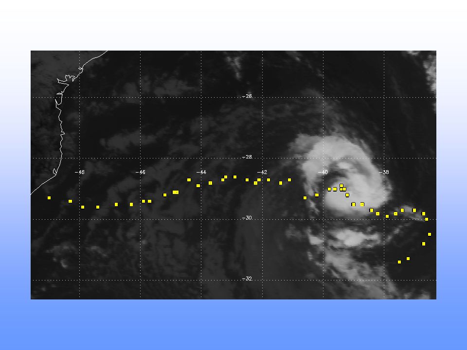
42
CATARINA TRMM (Tropical Rainfall Measuring Mission) estimated the radius of the eye of 20 to 25 km and the radius of the hurricane of about 500 km. It is believed that Catarina was a system with hybrid characteristics, formed as a tropical transition.

43
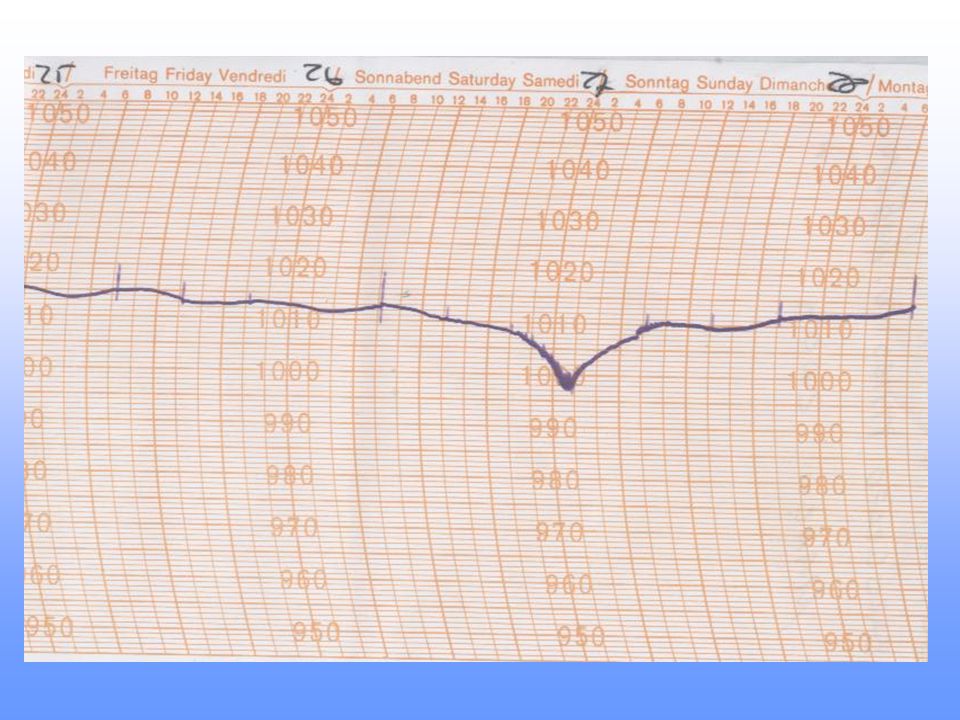
CHM, on 27 th March, issued severe weather warnings and characterised the system as follows: CATARINA WARNING NR 059/2004 GALE WARNING ISSUED AT 1400 GMT – SAT – 27/MAR/2004 NEAR GALE/SEVERE GALE WIND FORCE 7/9 SW/SE WITH GUSTS AFFECTING AREAS BRAVO/CHARLIE SOUTH OF 27S AND AREA ALFA NORTH OF 32S. VALID UNTIL 281800 GMT. PART TWO - WEATHER ANALYSIS AT 271200 LOW 1000 Hpa AS AN EXTRATROPICAL CYCLONE AT 29S046W WITH TROPICAL CHARACTERISTICS MOVING AT 6/8 KNOTS TO W/SW. THE PROGNOSIS IS TO REACH THE COAST OF RIO GRANDE DO SUL AND SANTA CATARINA AT 290000.

44
NUMBERS OF THE DESTRUCTION 150 km/h winds were estimated over the continent; 40 cities were affected in the state of SC; 5m waves near the coast; 2 boats were sunk with life losses; 2 people were killed and 76 were hurt over the continent; and in Criciúma, accumulated rain: 150 mm in about 3 hours.

Similar presentations


 Uneven solar energy inputs 2) Rotation of the Earth Global Circulation Patterns Local Events.>")


 and the Tropic of Capricorn (23.5S) The weather is very different.>")


 Tropical Cyclones (anywhere) Cyclones (Indian Ocean + others) Hurricanes (near N. America) 4/22/03.>")