Download presentation
Presentation is loading. Please wait.

1
What is it ? What does it do ? Under what circumstances would it be important ? PART I. The Department of Revenue is transitioning all assessment data to an electronic format by 2013 and photos and sketches by 2015. Electronic records management and integration has made its own business case, but there are parts of an ever evolving e-government process that is not widely understood. This is an open forum discussion covering everything with the evolving land records modernization process from: data standards and sharing, process improvement suggestions, finances, misconceptions, assumptions, ownership, protection and the future of electronic records. We will get into the heart of the issues surrounding the 3 plus million parcels that make up the State of Wisconsin. Part II. To be continued at the annual conference in 2013.

2
What play are we calling and is it designed to go left ?

3
What is the point ? What is the most important position on the field ?

8
The SOT

9
THE SOA

10
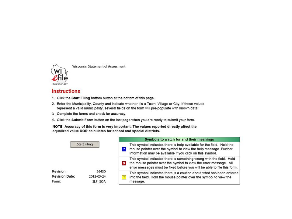
2013 Electronic Data Section 70.86, Wis. Stats., provides that, “The common council or other governing body of any city in this state may at its option adopt a simplified system of describing real property in either the assessment roll or the tax roll or in both the assessment roll and tax roll of such city, and may likewise from time to time amend or change such simplified system.” In1932, 21 Opinion of Attorney General 92 interpreted this to authorize a simplified system of describing real estate in assessment or tax rolls if the descriptions indicate the real estate intended with ordinary and reasonable certainty. Before any simplified system of describing real property is established, it is recommended that the municipality coordinate its system with the county real property lister and the county treasurer.

11
Electronic Data 70.23 W IS. S TATS Duties of assessors; entry of parcels on assessment roll. D UTIES OF THE LIO 59.72 Land information.

12
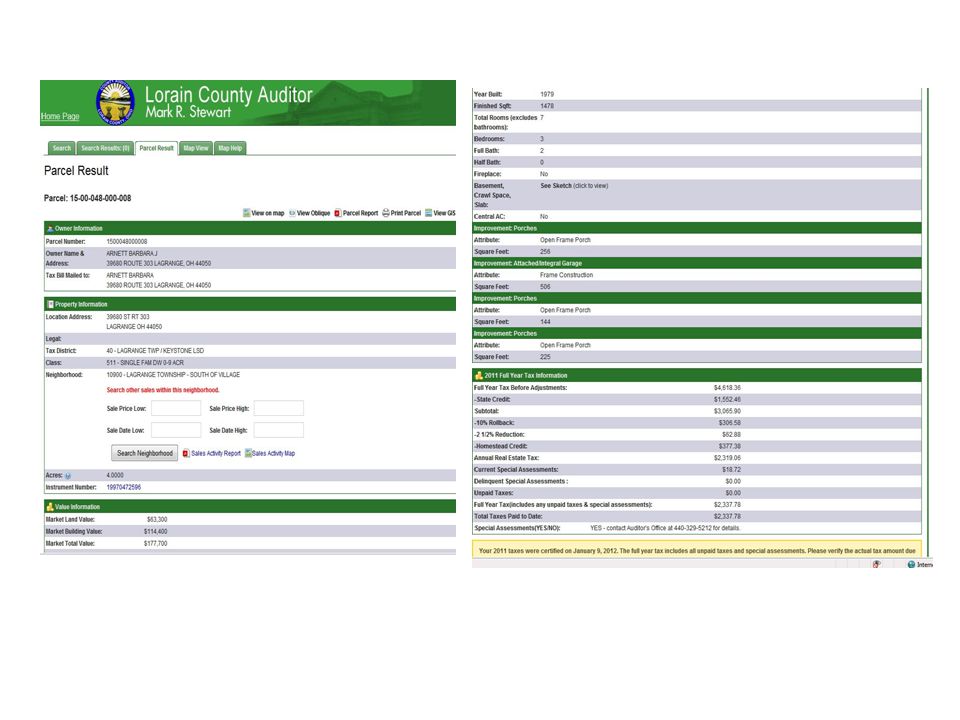
2) D UTIES OF LISTER. The county board may delegate any of the following duties to the lister: 70.09(2)(a)70.09(2)(a) (a) To prepare and maintain accurate ownership and description information for all parcels of real property in the county. That information may include the following: 70.09(2)(a)1.70.09(2)(a)1. 1. Parcel numbers. 70.09(2)(a)2.70.09(2)(a)2. 2. The owner's name and an accurate legal description as shown on the latest records of the office of the register of deeds. 70.09(2)(a)3.70.09(2)(a)3. 3. The owner's mailing address. 70.09(2)(a)4.70.09(2)(a)4. 4. The number of acres in the parcel if it contains more than one acre. 70.09(2)(a)5.70.09(2)(a)5. 5. School district and special purpose district codes. 70.09(2)(b)70.09(2)(b) (b) To provide information on parcels of real property in the county for the use of taxation district assessors, city, village and town clerks and treasurers and county offices and any other persons requiring that information. 70.09(2)(c)70.09(2)(c) (c) To serve as the coordinator between the county and the taxation districts in the county for assessment and taxation purposes. 70.09(2)(d)70.09(2)(d) (d) To provide computer services related to assessment and taxation for the assessors, clerks and treasurers of the taxation districts in the county, including but not limited to data entry for the assessment roll, notice of assessments, summary reports, tax roll and tax bills.
(a)70.09(2)(a) (a) To prepare and maintain accurate ownership and description information for all parcels of real property in the county. That information may include the following: 70.09(2)(a) (2)(a)1. 1. Parcel numbers (2)(a) (2)(a)2. 2. The owner s name and an accurate legal description as shown on the latest records of the office of the register of deeds (2)(a) (2)(a)3. 3. The owner s mailing address (2)(a) (2)(a)4. 4. The number of acres in the parcel if it contains more than one acre (2)(a) (2)(a)5. 5. School district and special purpose district codes (2)(b)70.09(2)(b) (b) To provide information on parcels of real property in the county for the use of taxation district assessors, city, village and town clerks and treasurers and county offices and any other persons requiring that information (2)(c)70.09(2)(c) (c) To serve as the coordinator between the county and the taxation districts in the county for assessment and taxation purposes (2)(d)70.09(2)(d) (d) To provide computer services related to assessment and taxation for the assessors, clerks and treasurers of the taxation districts in the county, including but not limited to data entry for the assessment roll, notice of assessments, summary reports, tax roll and tax bills..")
13
CORRECTION OF THE TAX ROLL Section 70.73, Wis. Stats., Correction of tax roll Provides: (1) Before Delivery. If it is discovered by any town, village, or city clerk or treasurer that any parcel of land has been erroneously described on the tax roll, the clerk or treasurer shall correct the description. If a town, village, or city clerk or treasurer discovers that personal property has been assessed to the wrong person, or two or more parcels of land belonging to different individuals or corporations have been erroneously assessed together on the tax roll, the clerk or treasurer shall notify the assessor and all parties interested, if the parties are residents of the county, by notice in writing to appear at the clerk’s office at some time, not less than five days thereafter, to correct the assessment roll, at which time and place the assessment roll shall be corrected by entering the names of the persons liable to assessment thereon, both as to real and personal property, describing each parcel of land and giving its proper valuation to each parcel separately owned; but the valuation so given to separate tracts of real estate shall not together exceed nor be less than the valuation given to the same property when the parcels were assessed together. Such valuation of parcels of land or correction of names of persons assessed with personal property may be made at any time before the tax roll shall be returned to the county treasurer for the year in which such tax is levied. Such valuation or correction of names, when so made, shall be held just and correct and be final and conclusive.
 Before Delivery. If it is discovered by any town, village, or city clerk or treasurer that any parcel of land has been erroneously described on the tax roll, the clerk or treasurer shall correct the description. If a town, village, or city clerk or treasurer discovers that personal property has been assessed to the wrong person, or two or more parcels of land belonging to different individuals or corporations have been erroneously assessed together on the tax roll, the clerk or treasurer shall notify the assessor and all parties interested, if the parties are residents of the county, by notice in writing to appear at the clerk’s office at some time, not less than five days thereafter, to correct the assessment roll, at which time and place the assessment roll shall be corrected by entering the names of the persons liable to assessment thereon, both as to real and personal property, describing each parcel of land and giving its proper valuation to each parcel separately owned; but the valuation so given to separate tracts of real estate shall not together exceed nor be less than the valuation given to the same property when the parcels were assessed together. Such valuation of parcels of land or correction of names of persons assessed with personal property may be made at any time before the tax roll shall be returned to the county treasurer for the year in which such tax is levied. Such valuation or correction of names, when so made, shall be held just and correct and be final and conclusive..")
14
REF 3.1 ASSESSMENT AND TAX ROLL INSTRUCTIONS FOR CLERKS (summary) SUMMARY – The assessor needs to: (1) Identify all general taxable real estate in the taxation district. (2) Value such property equitably. (3) Classify and list (coded and entered) in the columns under the heading “ACREAGE & VALUE OF DESCRIPTION SUBJECT TO GENERAL PROPERTY TAX”. (4) Crossfoot and balance the acres and values for each taxable legal description. (5) Review the summaries and compare the new totals with the previous year totals and current adjustments. Do not assume the entries and totals are always correct. (6) Complete and mail the Notices of Assessment as required by sec. 70.365, Wis. Stats. (7) Complete and file the AFR/MAR with the applicable DOR, Equalization Section District Office for the county in which this taxation district is located (see page 1 for list). The final assessment roll is given to the clerk once the personal property and other sections are completed. The clerk inspects the roll, makes any BOR changes and has the information loaded to the database. After receiving an updated summary, the clerk completes the SOA bound in the roll. The clerk then transcribes the data onto DOR’s copy of the SOA and files the SOA with DOR, or with the county if the county files the SOA for the clerk.
 Value such property equitably. (3) Classify and list (coded and entered) in the columns under the heading ACREAGE & VALUE OF DESCRIPTION SUBJECT TO GENERAL PROPERTY TAX . (4) Crossfoot and balance the acres and values for each taxable legal description. (5) Review the summaries and compare the new totals with the previous year totals and current adjustments. Do not assume the entries and totals are always correct. (6) Complete and mail the Notices of Assessment as required by sec , Wis. Stats. (7) Complete and file the AFR/MAR with the applicable DOR, Equalization Section District Office for the county in which this taxation district is located (see page 1 for list). The final assessment roll is given to the clerk once the personal property and other sections are completed. The clerk inspects the roll, makes any BOR changes and has the information loaded to the database. After receiving an updated summary, the clerk completes the SOA bound in the roll. The clerk then transcribes the data onto DOR’s copy of the SOA and files the SOA with DOR, or with the county if the county files the SOA for the clerk..")
16
Polygons that do not exist Name 10 MFL R/W – R/W undeveloped – R/W fronting Ag – R/W that is AG – R/W Classified as use

17
Polygons that do not exist Name 10 Swamp Productive forest Ag Forest Agriculture Grade 1 Grade 2 Grade 3 Pasture CRP WRP CREP All Easements

18
Polygons that do not exist Swamp TIF/TID

19
Some R/W is parcelizied

20
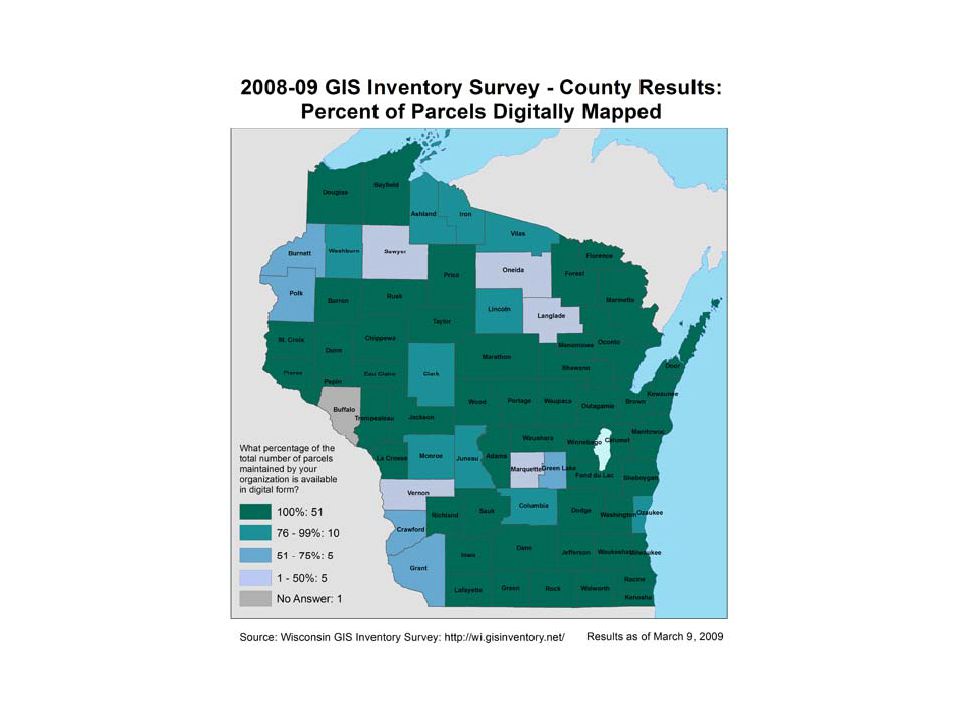
Parcel Standards

21
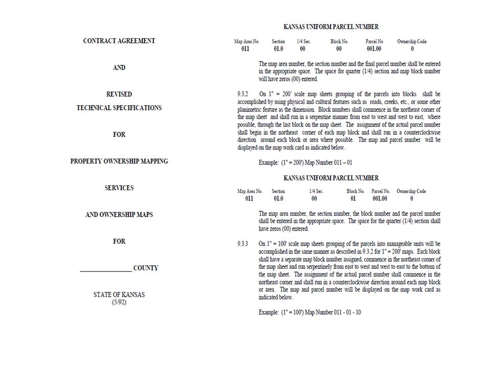
Dunn County EXAMPLE 17006-2-261305-110-0001 17= is the County number (Dunn) -006 = is the muni code ( T Eau Galle) -2 = west of the 4 th principal meridian 26=Township 13 =Range 05=Section number -1=1/4 section 10=1/4 ¼ or std tract Code -0001 =local parcel number 19 digits total including spaces
 -006 = is the muni code ( T Eau Galle) -2 = west of the 4 th principal meridian 26=Township 13 =Range 05=Section number -1=1/4 section 10=1/4 ¼ or std tract Code =local parcel number 19 digits total including spaces")
22
Oneida County WR 161-1 PE 23 Dodge County 00209173634003

26
THE WPAM

27
The County Section 70.86, Wis. Stats., provides that, “The common council or other governing body of any city in this state may at its option adopt a simplified system of describing real property in either the assessment roll or the tax roll or in both the assessment roll and tax roll of such city, and may likewise from time to time amend or change such simplified system.” In 1932, 21 Opinion of Attorney General 92 interpreted this to authorize a simplified system of describing real estate in assessment or tax rolls if the descriptions indicate the real estate intended with ordinary and reasonable certainty. Before any simplified system of describing real property is established, it is recommended that the municipality coordinate its system with the county real property lister and the county treasurer.

28
Back to ELECTRONIC DATA Is XML in the assessment roll an acceptable standard ? Are more standards needed ? – What do you suggest.

29
The 4-4 Blast-right needs to be simplified.

30
WLIA INVOLVEMENT

31
Recommendation

32
Goals

33
The Solutions

38
Foundational Elements vs. Framework Data Originally, the Wisconsin Land Information Board identified eight Foundational Elements – five technical and three institutional - against which to measure progress and set goals for the program. These elements were identified as: Geographic reference frameworks including digital orthophotos Parcels Soils Wetlands Zoning Institutional arrangements Communication, education and training Public access In the late 1990s, seven more elemental categories were added including: Parcel administration Election and administrative boundaries Street address and street network systems Land use mapping Natural resources Database design Infrastructure and facility management

42
Since 1990 WLIP has invested $159,000,000 into land records modernization Fees under 59.72(5) wis stats 16.967(7) wis stats
 wis stats (7) wis stats")
44
What data sets and players are missing from this discussion?

45
eRETR and Provide assessment data(PAD) MLS ______________ ____________________________ _________________________________
 MLS ______________ ____________________________ _________________________________")
47
MFL all types

48
E-911 Roads and parcels If a truck blows through a stop sign on Co Rd J and 16/60, AKA "O Sixteen" and I need medical attention, "NOW" how do I make sure they don’t go to the Co Rd J by Grove Prairie Cemetery ?

49
The Kroll Deer Report figures into this DEER, REALLY ? What is the implementation schedule: October 23,2012

51
RECOMMENDATIONS We suggest research and development related to habitat health and range assessment, modeled after Lay (1967). 1. As both part of DMAP activities and public lands management, local biologists/technicians should be required to conduct annual range evaluations to assess habitat health and condition. These assessments would have direct field involvement by the public and DMAP cooperators. 1. Training programs (Extension) should be developed for state and private resource managers to standardize habitat/range assessment methodologies. 2. There is a need for modernizing the GIS and GPS capabilities of Wisconsin’s agencies. 66 3. A statewide geospatial information system, similar to that developed for Texas, should be developed which provides seamless support to all state resource managers across agencies. This would include both access to and generation of geospatial data, and coordinated by the Wisconsin State Cartographer’s Office. This would permit significant leveraging of research and development dollars by allowing data generated for a specific project to be used by all. For example, a land cover map could be used to support commercial development of forest products, but at the same time support everything from deer management to emergency response and preparedness to economic development and feasibility. 4. Funding for these activities should arise from fees assessed by stakeholders and landowners using these data and services, as well as grants and contracts for various state agency activities. 5. The WDNR adopt an advocacy role in dealing with the National Forests of Wisconsin to encourage sustainable forest management, especially for early and mid-successional species (game and non-game). We also suggest and encourage action by Wisconsin federal representatives to improve the sustainability of Wisconsin’s federal lands. 6. Form a Young Forest Initiative Task Force. Concerns about the decreasing areas of early successional forest habitats in the Northern and Central Forests were expressed at the Deer Trustee meetings with WDNR (November 2011) and with other agency and NGO stakeholders (January 2012) as well as by participants of the April Town Hall meetings. Maturing forests with decreasing early successional habitats also has been identified as a major factor leading to declining deer harvests in several states (McKean 2011). The QDMA (2009) reported that while total forested area in Wisconsin increased by 446,000 acres from 1996-2007, the area of early successional forests declined by 1.3 million acres. This trend is particularly disturbing on public lands, especially the National Forests, and has been driven by public concerns about clear cutting and protecting the environment, depressed timber markets, and cumbersome planning processes and litigation against proposed timber harvests on National Forest lands (Thomas and Sienkiewicz 2011a, b). The decline of early successional forest habitats also has serious implications for other game species such as ruffed grouse and nongame species such as Kirtland’s Warbler which needs large areas of dense young Jack Pine stands for breeding habitat. Thus, we recommend the formation of a Wisconsin Young Forest Initiative Task Force to assess the decline of young forests across the state and define appropriate actions to slow or reverse this trend. The importance of fire as a disturbance factor in creation of forest communities and the impacts of invasive species also should be included in their charge. The Task Force should pay particular attention to lands in the MFL program as well as National Forest Lands. The Task Force should include representatives from the US Forest Service, state, county and municipal foresters, consulting foresters, the forest industry, the Wisconsin Conservation Congress, NIPF landowners, the Wisconsin Wildlife Federation, NGOs such as QDMA, WU, NWTF, RGS, and others.
 should be developed for state and private resource managers to standardize habitat/range assessment methodologies. 2. There is a need for modernizing the GIS and GPS capabilities of Wisconsin’s agencies A statewide geospatial information system, similar to that developed for Texas, should be developed which provides seamless support to all state resource managers across agencies. This would include both access to and generation of geospatial data, and coordinated by the Wisconsin State Cartographer’s Office. This would permit significant leveraging of research and development dollars by allowing data generated for a specific project to be used by all. For example, a land cover map could be used to support commercial development of forest products, but at the same time support everything from deer management to emergency response and preparedness to economic development and feasibility. 4. Funding for these activities should arise from fees assessed by stakeholders and landowners using these data and services, as well as grants and contracts for various state agency activities. 5. The WDNR adopt an advocacy role in dealing with the National Forests of Wisconsin to encourage sustainable forest management, especially for early and mid-successional species (game and non-game). We also suggest and encourage action by Wisconsin federal representatives to improve the sustainability of Wisconsin’s federal lands. 6. Form a Young Forest Initiative Task Force. Concerns about the decreasing areas of early successional forest habitats in the Northern and Central Forests were expressed at the Deer Trustee meetings with WDNR (November 2011) and with other agency and NGO stakeholders (January 2012) as well as by participants of the April Town Hall meetings. Maturing forests with decreasing early successional habitats also has been identified as a major factor leading to declining deer harvests in several states (McKean 2011). The QDMA (2009) reported that while total forested area in Wisconsin increased by 446,000 acres from , the area of early successional forests declined by 1.3 million acres. This trend is particularly disturbing on public lands, especially the National Forests, and has been driven by public concerns about clear cutting and protecting the environment, depressed timber markets, and cumbersome planning processes and litigation against proposed timber harvests on National Forest lands (Thomas and Sienkiewicz 2011a, b). The decline of early successional forest habitats also has serious implications for other game species such as ruffed grouse and nongame species such as Kirtland’s Warbler which needs large areas of dense young Jack Pine stands for breeding habitat. Thus, we recommend the formation of a Wisconsin Young Forest Initiative Task Force to assess the decline of young forests across the state and define appropriate actions to slow or reverse this trend. The importance of fire as a disturbance factor in creation of forest communities and the impacts of invasive species also should be included in their charge. The Task Force should pay particular attention to lands in the MFL program as well as National Forest Lands. The Task Force should include representatives from the US Forest Service, state, county and municipal foresters, consulting foresters, the forest industry, the Wisconsin Conservation Congress, NIPF landowners, the Wisconsin Wildlife Federation, NGOs such as QDMA, WU, NWTF, RGS, and others..")
53
Players,coaches, refs: county RPLS LIO's Feds DNR DOT DOR DATCP DOA SCO Towns Village City SAGIC WIGIC WLIA Money Standards Process Business use Ownership Misconceptions Schedule

Similar presentations


 Lack of detailed wetlands inventory information or guidance.>")


