Download presentation
Presentation is loading. Please wait.

1
A Potential Trinational Protected Area: the Campo-Tecate Creek Kumiai Corridor photo from CUNA

2
A blueprint for potential trinational protected area that would benefit the Campo Indian Reservation, the United States, and Mexico Disconnected cities Disconnected wildlife corridors

4
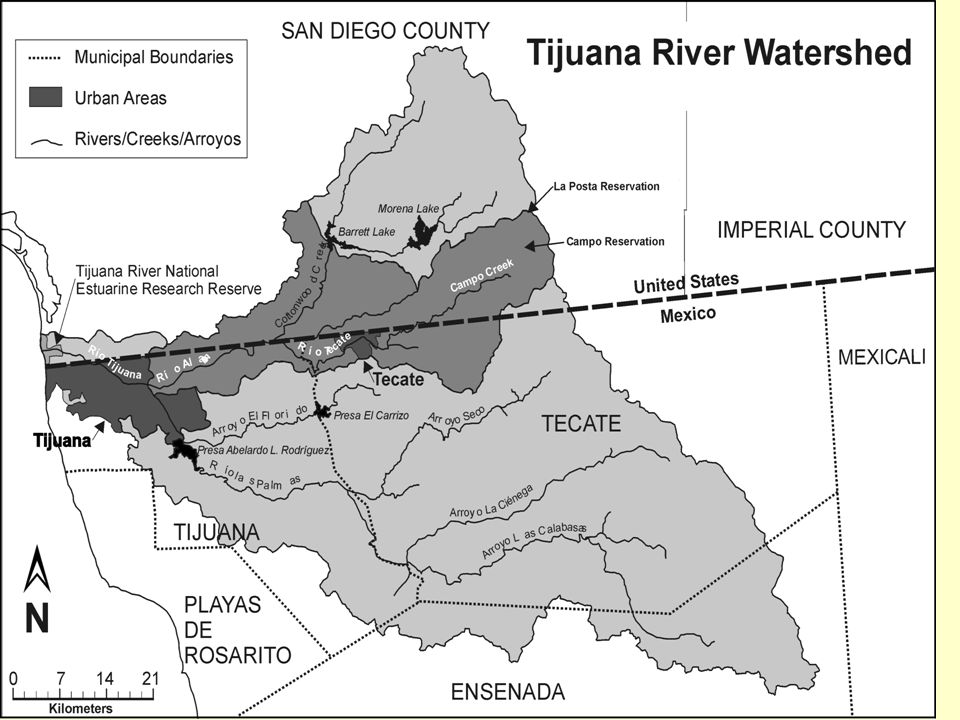
Why a Kumiai Corridor? Three nationsone river Good trinational planning example Existing programs and protected areas Plans for Tecate River Park A cultural focus draws stakeholders

5
Some potential stakeholders Back Country Land Trust· California Environmental Protection Agency (Cal EPA), Campo Environmental Protection Agency (Campo EPA)· Colegio de la Frontera Norte (College of the Northern Border) (COLEF)· Comisión Estatal de Servicios Públicos (State Commission of Public Services of Tecate) (CESPTE)· Comisión Nacional de Agua (National Water Commission) (CNA)· Comisión Nacional de Areas Naturales Protegidas (National Commission for Protected Areas) (CONAP)· County of San Diego· Dirección General de Ecología (State Secretary of Ecology) (DGE)· Fundación la Puerta, A.C. (La Puerta Foundation, A.C.)· Instituto de Culturas Nativas (Native Cultures Institute) (CUNA)· International Boundary and Water Commission (IBWC-CILA)· International Community Foundation (ICF)· Kumeyaay Indian communities: Campo Band of Kumayaay Indians, San José de la Zorra, San José Tecate, Juntas de Neji, and San Antonio Nécua. Mountain Empire Resources Information Taskforce (MERIT) · Municipality of Tecate· Pronatura, A.C.· Proyecto Bioregional de Educación Ambiental (Bio-regional Environmental Education Project) (PROBEA)· San Diego State University (SDSU)· Secretaría de Agricultura, Ganadería, Desarrollo Rural, Pesca y Alimentación (Ministry of Agriculture, Livestock, Rural Development, Fisheries and Food) (SAGARPA) · Secretaría de Infrastructura y Desarollo Urbano del Estado (State Secretary of Infrastructure and Urban Development) (SIDUE)· Secretaría del Medio Ambiente y Recursos Naturales (Secretary of the Environment and Natural Resources) (SEMARNAT)· Terra Peninsular, A.C.· The Nature Conservancy (TNC)· U.S. Environmental Protection Agency (U.S. EPA)· Universidad Autónoma de Baja California (Autonomous University of Baja California) (UABC)
· Instituto de Culturas Nativas (Native Cultures Institute) (CUNA)· International Boundary and Water Commission (IBWC-CILA)· International Community Foundation (ICF)· Kumeyaay Indian communities: Campo Band of Kumayaay Indians, San José de la Zorra, San José Tecate, Juntas de Neji, and San Antonio Nécua. Mountain Empire Resources Information Taskforce (MERIT) · Municipality of Tecate· Pronatura, A.C.· Proyecto Bioregional de Educación Ambiental (Bio-regional Environmental Education Project) (PROBEA)· San Diego State University (SDSU)· Secretaría de Agricultura, Ganadería, Desarrollo Rural, Pesca y Alimentación (Ministry of Agriculture, Livestock, Rural Development, Fisheries and Food) (SAGARPA) · Secretaría de Infrastructura y Desarollo Urbano del Estado (State Secretary of Infrastructure and Urban Development) (SIDUE)· Secretaría del Medio Ambiente y Recursos Naturales (Secretary of the Environment and Natural Resources) (SEMARNAT)· Terra Peninsular, A.C.· The Nature Conservancy (TNC)· U.S. Environmental Protection Agency (U.S. EPA)· Universidad Autónoma de Baja California (Autonomous University of Baja California) (UABC).")
6
Historical locations of Native American Groups

7
Servidumbre CuchumáCampo Indian Reservation Anchors for a 100 meter-wide biodiverse riparian ribbon through urban Tecate and rural San Diego lands

8
Two Phases Phase 1: lands are protected within national boundaries, using a variety of instruments. Phase 2: weld the protected areas across boundaries. See:Laguna Madre binational conservation area plan (TNC 2001),
,.")
9
Long term: Stretch the protected area from the Laguna Mountains to the Tijuana Estuary, and widen the 50 m buffer

10
Phase 1: Campo Indian Reservation Section

11
Campo Steps A protected area ordinance, or program, for example, could be passed by the Tribal Council and monitored by Campo EPA Programs could generate income and foster cultural values for the residents through: sustainable reed harvesting, traditional basket making and sales, a native plant nursery, medicinal plant harvesting, food harvesting, and ecotourism and cultural ecotourism. (input from Phil Green and Mike Connolly March 2004)
.")
12
San Diego Section

13
San Diego Steps Immediate legal protection of public (County and BLM) and private lands along river through an easement of approximately 15 km x 100 m Establish a Campo River Conservancy to acquire additional lands and manage the land see for example the San Diego Conservancy Law 2002
 and private lands along river through an easement of approximately 15 km x 100 m Establish a Campo River Conservancy to acquire additional lands and manage the land see for example the San Diego Conservancy Law 2002")
14
U.S. Mexico

15
Tecate Steps 1.Convene stakeholders, landowners, and government officials* 2.Agree on the objectives for the River Park* 3.Organize a publicity campaign to involve the public 4.Agree on the functions of the different actors 5.Create a realistic timeline and budget* 6.Map out the legal issues* 7.Complete the concession of administration rights to the federal zone from CNA to the City of Tecate Many steps suggested by Martín Guittierez, Pronatura have been completed with the assistance of Rancho La Puerta, A.C.

16
Tecate Suggested Steps 8.Create a servidumbre público, or easement, between CNA and another parcel, with third party NGO oversight. 9.Create additional easements between CNA and adjacent landowners to widen the Park With input from Fernando Ochoa and Miguel Angel Vargas, PRONATURA

17
Phase 2Welding the easements Between Campo Indian Reservation and the Campo River Conservancyan MOU At U.S.-Mexican border (Joe Bill Canyon) follow Cuchumá easement example Between Joe Bill and the Tecate River Park continue that ecological easement through private lands Between Servidumbre Cuchumá and the Tecate River Parkcontinue that ecological easement through Rancho La Puerta
 follow Cuchumá easement example Between Joe Bill and the Tecate River Park continue that ecological easement through private lands Between Servidumbre Cuchumá and the Tecate River Parkcontinue that ecological easement through Rancho La Puerta")
18
Kumiai Corridor: Conserve the natural and cultural resources and increase property values and economies

19
Some tools that are available to conserve land in the United States and Mexico

23
Questions for breakout groups: Which of these land conservation tools would work in your border area? What are the welding mechanisms (across borders) that might work in your area?
 that might work in your area .")
Similar presentations


 769-5038.>")


 OPERATIONS Federal Surface Management.>")
 Natural and cultural biodiversity.>")
 September 8, 2009 Permitting and Compliance.>")


