Download presentation
Presentation is loading. Please wait.

1
16.2 Changing weather

2
Discuss what happens when air masses meet
Learning Targets Describe the characteristics of air masses and how they get those characteristics Discuss what happens when air masses meet List the differences between stationary, cold, warm, and occluded fronts

3
Formation of Air Masses
Air with similar temperature and humidity (characteristics) Source Region - Temperature and humidity based on where they form or travel across May be 1000 miles across An air mass gets its characteristics from the ground or water it is above, and it also shares those characteristics with the regions that it travels over. Air masses are created primarily in high pressure zones. They most commonly form in polar and tropical regions, which have very distinctive temperature and humidity. The temperate zones are ordinarily too unstable for air masses to form. Instead, air masses move across them, making the middle latitudes the site of very interesting weather.
 Source Region - Temperature and humidity based on where they form or travel across. May be 1000 miles across. An air mass gets its characteristics from the ground or water it is above, and it also shares those characteristics with the regions that it travels over. Air masses are created primarily in high pressure zones. They most commonly form in polar and tropical regions, which have very distinctive temperature and humidity. The temperate zones are ordinarily too unstable for air masses to form. Instead, air masses move across them, making the middle latitudes the site of very interesting weather.")
4
Formation of Air Masses
Storms form when air mass and region it moves over have different characteristics Cold air mass moving over warmer ground Bottom layer heated, air rises, form clouds and precipitation Warm air mass moving over colder ground Forms inversions An air mass gets its characteristics from the ground or water it is above, and it also shares those characteristics with the regions that it travels over. Air masses are created primarily in high pressure zones. They most commonly form in polar and tropical regions, which have very distinctive temperature and humidity. The temperate zones are ordinarily too unstable for air masses to form. Instead, air masses move across them, making the middle latitudes the site of very interesting weather.

5
} Types of Air Masses Latitude Cold air masses flow toward equator
Warm air masses flow toward poles Continental (c) or Maritime (m) – Source Region Arctic (A) Polar (P) Tropical (T) Equatorial (E) } Latitude An air mass gets its characteristics from the ground or water it is above, and it also shares those characteristics with the regions that it travels over. Air masses are created primarily in high pressure zones. They most commonly form in polar and tropical regions, which have very distinctive temperature and humidity. The temperate zones are ordinarily too unstable for air masses to form. Instead, air masses move across them, making the middle latitudes the site of very interesting weather.
 or Maritime (m) – Source Region. Arctic (A) Polar (P) Tropical (T) Equatorial (E) } Latitude. An air mass gets its characteristics from the ground or water it is above, and it also shares those characteristics with the regions that it travels over. Air masses are created primarily in high pressure zones. They most commonly form in polar and tropical regions, which have very distinctive temperature and humidity. The temperate zones are ordinarily too unstable for air masses to form. Instead, air masses move across them, making the middle latitudes the site of very interesting weather.")
6
First symbol tells whether the air mass had its origin over a continent (c) or over an ocean (m, for maritime). second symbol tells the general latitude where the air mass gained its temperature and humidity traits. The categories are arctic (A), polar (P,) tropical (T), and equatorial (E).
, polar (P,) tropical (T), and equatorial (E).")
7
In general, cold air masses tend to flow toward the equator and warm air masses tend to flow toward the poles. If the air mass is very different from the ground beneath it, storms may form. For example, when a colder air mass moves over warmer ground, the bottom layer of air is heated. That air rises, forming clouds, rain, and sometimes thunderstorms. When a warmer air mass travels over colder ground, the bottom layer of air is cooled. This forms a temperature inversion, since the cold air near the ground is trapped. Inversions may form stratus clouds, advection fogs, or they may trap a layer of pollution over a city.

8
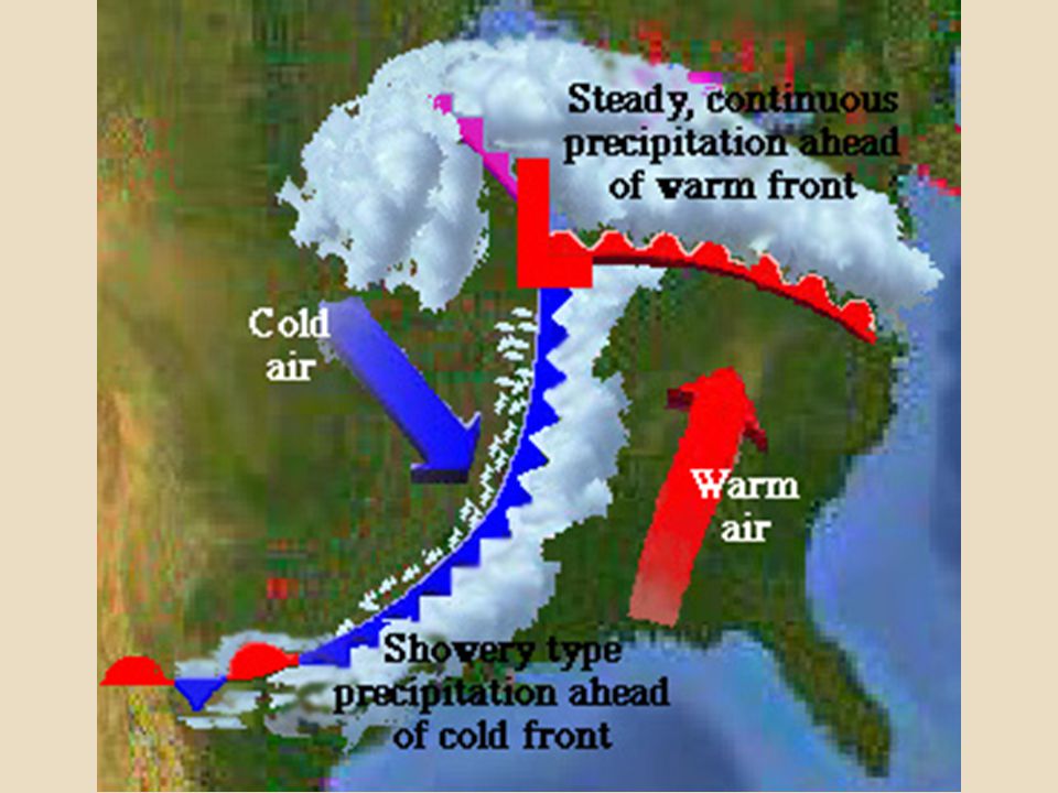
Fronts Storms Where 2 air masses meet
Different temperature, humidity, density Do NOT mix One goes up; one goes down Hot is less dense goes up Rising warm air creates a low pressure zone, A.K.A pressure is lifted up thereby lowering the pressure. If the lifted air is moist enough, there will be condensation and precipitation. Fronts usually also have winds in them. If the temperature difference between the two air masses is high, then the winds will be strong

10
Stationary Front Neither air mass is moving
Steady wind and precipitation Front may become stationary if an air mass is stopped by a barrier. For example, cold air masses may be stopped by mountains, because the cold air mass is too dense to rise over them

13
Animation of all 4 fronts

14
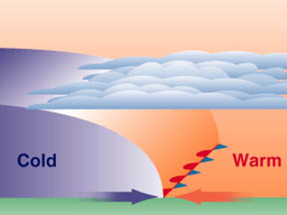
Cold Front Cold air moving into area covered by warm air
Cold (dense) air pushes warm (less dense) air up Humidity high enough forms clouds and precipitation Remember - warm air holds more moisture When a cold air mass takes the spot of a warm air mass, there is a cold front. Since cold air is denser than the warm air, the cold air mass slides beneath the warm air mass and pushes it up. As the warm air rises, there are often storms.
 air pushes warm (less dense) air up. Humidity high enough forms clouds and precipitation. Remember - warm air holds more moisture. When a cold air mass takes the spot of a warm air mass, there is a cold front. Since cold air is denser than the warm air, the cold air mass slides beneath the warm air mass and pushes it up. As the warm air rises, there are often storms.")
15
Fast-moving cold fronts create a line of intense storms over a fairly short distance.
Along the cold front, the denser, cold air pushes up the warm air, causing the air pressure to decrease. If the humidity is high enough, some types of cumulus clouds will grow. At the front, there will be a line of rain or snow showers or thunderstorms with blustery winds. Behind the front is the cold air mass. This mass is drier and so precipitation stops.

16
Squall line – line of severe thunderstorms that forms along a cold front

17
Animation of all 4 fronts

18
The weather at a cold front varies with the season
The weather at a cold front varies with the season. Thunderstorms or tornadoes may form in spring and summer, when the air is unstable. The points are in the direction the front is moving. Blue triangles looks like ice cycles = cold.

19
In the autumn, strong rains fall over a large area
In the autumn, strong rains fall over a large area. If the front moves slowly, enough rain may fall to cause flooding. Cold fronts in winter may bring frigid temperatures and heavy snows.

20
Cold Front varies with Seasons
Spring & Summer – Air unstable create thunderstorms & tornadoes Spring – If temperature gradient high, strong winds blow Autumn – Strong rains Winter – Source region in arctic bringing frigid temperatures and snows

21
Warm air moving over land covered by cold air
Warm Front Warm air moving over land covered by cold air Warm air is slides over cold air Atmosphere is stable create inversions

22
The transition between the cold air and the warm air takes place over a long distance. This means that the first signs of changing weather appear long before the front is actually over you.

23
Winds grow stronger as the low pressure approaches
Winds grow stronger as the low pressure approaches. As the front gets closer, the cold air mass is just above you but the warm air mass is not too far above that. The weather worsens. Warm and cold air mix at the front, leading to the formation of stratus clouds and fog.

24
Cold and Warm front

25
Animation of all 4 fronts

29
Occluded Front Forms around a low pressure zone L
Cold front catches up with a warm front Air masses are cold, warm, cold Variable and unpredictable weather as the various air masses mix Cyclones more on this later Forms around a low pressure system.

30
The occlusion starts when a cold front catches up to a warm front.

31
The air masses, in order from front to back, are cold, warm, and then cold again. The boundary line, where the two fronts meet, curves towards the pole because of the Coriolis Effect. The weather is especially fierce right at the occlusion.

33
Animation of all 4 fronts

Similar presentations