Download presentation
Presentation is loading. Please wait.

1
New Developments for OPUS Dr. Mark Schenewerk Mark.Schenewerk@noaa.gov 816-994-3009

2
Who is this guy? I am Mark Schenewerk with National Geodetic Survey (NGS). B.S. from the University of Missouri at Rolla. Ph.D. from the University of Illinois at Champaign-Urbana. The NGS calls me a geodesist, but I’m actually an astronomer who happens to do things that look like geodesy. I am the “father” of the PAGES processing software. I’ve been (very) indirectly involved in OPUS since its inception and directly involved in some of the new development for the last two years. 2011-03-03 2
 indirectly involved in OPUS since its inception and directly involved in some of the new development for the last two years")
3
Workshop Outline What is OPUS? (≈1.5 hr) An overview of OPUS in which I’ll “pull back the curtain” a bit and let you see what’s going on behind the web pages. BREAK New Developments for OPUS (≈0.5 hr) A summary of pending enhancements and new capabilities. BREAK OPUS-Projects (≈1 hr) On-line access to project organization and processing tools. 2011-03-03 3
 An overview of OPUS in which I’ll pull back the curtain a bit and let you see what’s going on behind the web pages. BREAK New Developments for OPUS (≈0.5 hr) A summary of pending enhancements and new capabilities. BREAK OPUS-Projects (≈1 hr) On-line access to project organization and processing tools")
4
I’m an informal speaker, so feel free to ask questions. I will show examples of the web pages for completeness, but I am assuming a basic familiarity with the existing OPUS web sites. If you find any discussion about a web page too terse, ask for clarification. 2011-03-03 4 Workshop Outline

5
What is OPUS? To better understand where OPUS is going, let’s begin by reviewing the who, what, when, where and why of OPUS as it is today. 2011-03-03 5

6
What is OPUS? OPUS, the On-line Positioning User Service, is a growing set of applications offering web-based access to the tools and resources provided by the NGS. Currently, OPUS is composed of: OPUS-S....... static processing OPUS-RS...... rapid-static processing OPUS-DB...... data base and publishing Reviewing each of these individually… 2011-03-03 6

7
OPUS-S....... static processing A Little OPUS-S History. The OPUS-S Interface. How Good Can I Do With OPUS-S? A Quick Example. The Extended Report. Back To Our Quick Example. How Does OPUS-S Work? OPUS-S Uploads By Month. 2011-03-03 7

8
A Little OPUS-S History. In the late 1990’s, a growing number of organizations were making their Continuously Operating Reference Station (CORS) data publically available with a short latency. Supporting products such as precise ephemerides were improving and also becoming available with a short latency. Many organizations recognized that the time seemed ripe for some sort of on-line, processing service. 2011-03-03 8
 data publically available with a short latency. Supporting products such as precise ephemerides were improving and also becoming available with a short latency. Many organizations recognized that the time seemed ripe for some sort of on-line, processing service")
9
A Little OPUS-S History. In the NGS, Gerry Mader started promoting the idea of a processing service. Specifically he envisioned a web-based service that was as simple as possible without significantly sacrificing accuracy thereby creating a tool useful to the largest possible group of potential users. The NGS recognized that such a service could also be an effective tool to disseminate the National Spatial Reference System (NSRS). 2011-03-03 9
")
10
A Little OPUS-S History. Mader and Weston (NGS) cloistered themselves and, with the help others too numerous to be mentioned here, created OPUS, now called OPUS-S, essentially as it exists today. After an extended trial period, OPUS was formally made available to the public in 2002. 2011-03-03 10
 cloistered themselves and, with the help others too numerous to be mentioned here, created OPUS, now called OPUS-S, essentially as it exists today. After an extended trial period, OPUS was formally made available to the public in")
11
The OPUS-S Interface. Beautiful in its simplicity, the user need only provide: Their email address. The antenna type. The offset to the antenna reference point (ARP). 2- to 48-hours of GPS L1 + L2 data. In turn, the user receives: Coordinates accurate to a few centimeters. 2011-03-03 11
. 2- to 48-hours of GPS L1 + L2 data. In turn, the user receives: Coordinates accurate to a few centimeters")
12
The OPUS-S Interface. 2011-03-03 12 http://www.ngs.noaa.gov/OPUS/ This is the OPUS home page used to submit data to the OPUS processing queues. To use OPUS-S, complete the four fields, then click the “Upload to STATIC” button. In a few minutes, an email arrives with the results.

13
How Good Can I Do With OPUS-S? OPUS-S reliably addresses the more historically conventional requirements for GPS data processing. It typically yields accuracies of: 1 – 2 cm horizontally 2 – 4 cm vertically. However, there is no guarantee that this stated accuracy will result from any given data set. Confirming the quality of the OPUS solution remains the user’s responsibility. That’s the “price” for automated processing. 2011-03-03 13

14
How Good Can I Do With OPUS-S? As a quality test, 2-hour data sets from more than 200 CORS were submitted to OPUS-S and the results compared to the accepted coordinates. Mean:<0.1 cm N-S RMS:0.8 cm E-W RMS:1.4 cm 2011-03-03 14 Weston, N. “OPUS: Online Positioning User Service”, CGSIC USSLS MEETING, 2008-07-08, NEW ORLEANS, LA.

15
How Good Can I Do With OPUS-S? Same data sets. Same analysis but for the vertical. The vertical is always a little more interesting. Mean:<0.1 cm U-D RMS:1.9 cm 2011-03-03 15 Weston, “OPUS: Online Positioning User Service”, CGSIC USSLS MEETING, 2008-07-08, NEW ORLEANS, LA

16
How Good Can I Do With OPUS-S? More generally, Eckl et al. (NGS) preformed a similar but more extensive test using the same software but outside OPUS. 2011-03-03 16 Eckl et al., 2001, “Accuracy of GPS-derived relative positions as a function of interstation distance and observing-session duration”, J. of Geod. 75, 633-640). Their results provide a good “rule of thumb” for accuracy versus session duration when using OPUS-S and in many other applications.
 preformed a similar but more extensive test using the same software but outside OPUS Eckl et al., 2001, Accuracy of GPS-derived relative positions as a function of interstation distance and observing-session duration , J. of Geod. 75, ). Their results provide a good rule of thumb for accuracy versus session duration when using OPUS-S and in many other applications..")
17
A Quick Example. As an example, 2-hours of 2009-059 data from CORV, a PBO CORS in Oregon were submitted to OPUS-S. 2011-03-03 17

18
A Quick Example. Here is part of the report for this submission. FYI, these results differ 2.1 cm horizontally and 1.6 cm vertically from the accepted position projected to the epoch of the data. 2011-03-03 18 USER: mark.schenewerk@noaa.gov DATE: March 31, 2010 RINEX FILE: corv059f.09o TIME: 19:43:42 UTC SOFTWARE: page5 0909.08 master40.pl 081023 START: 2009/02/28 05:00:00 EPHEMERIS: igs15206.eph [precise] STOP: 2009/02/28 06:59:00 NAV FILE: brdc0590.09n OBS USED: 5984 / 6181 : 97% ANT NAME: ASH700936C_M NONE # FIXED AMB: 31 / 31 : 100% ARP HEIGHT: 1.521 OVERALL RMS: 0.009(m) REF FRAME: NAD_83(CORS96)(EPOCH:2002.0000) ITRF00 (EPOCH:2009.1596) X: -2498422.603(m) 0.011(m) -2498423.344(m) 0.011(m) Y: -3802821.159(m) 0.007(m) -3802819.941(m) 0.007(m) Z: 4454736.661(m) 0.021(m) 4454736.734(m) 0.021(m) LAT: 44 35 7.91060 0.016(m) 44 35 7.92618 0.016(m) E LON: 236 41 43.48046 0.013(m) 236 41 43.42207 0.013(m) W LON: 123 18 16.51954 0.013(m) 123 18 16.57793 0.013(m) EL HGT: 106.011(m) 0.014(m) 105.627(m) 0.014(m) ORTHO HGT: 128.542(m) 0.020(m) [NAVD88 (Computed using GEOID09)] UTM COORDINATES STATE PLANE COORDINATES UTM (Zone 10) SPC (3601 OR N) Northing (Y) [meters] 4936954.909 105971.559 Easting (X) [meters] 475821.304 2277335.367 Convergence [degrees] -0.21381419 -1.98897513 Point Scale 0.99960719 0.99994603 Combined Factor 0.99959057 0.99992941 US NATIONAL GRID DESIGNATOR: 10TDQ7582136954(NAD 83) BASE STATIONS USED PID DESIGNATION LATITUDE LONGITUDE DISTANCE(m) DH4503 P376 EOLARESVR_OR2004 CORS ARP N445628.313 W1230608.100 42648.2 DE6258 MCSO MARION CNTY COOP CORS ARP N445825.701 W1225720.639 51226.8 DG5352 STAY STAYTON COOP CORS ARP N444950.530 W1224915.036 47030.9
 REF FRAME: NAD_83(CORS96)(EPOCH: ) ITRF00 (EPOCH: ) X: (m) 0.011(m) (m) 0.011(m) Y: (m) 0.007(m) (m) 0.007(m) Z: (m) 0.021(m) (m) 0.021(m) LAT: (m) (m) E LON: (m) (m) W LON: (m) (m) EL HGT: (m) 0.014(m) (m) 0.014(m) ORTHO HGT: (m) 0.020(m) [NAVD88 (Computed using GEOID09)] UTM COORDINATES STATE PLANE COORDINATES UTM (Zone 10) SPC (3601 OR N) Northing (Y) [meters] Easting (X) [meters] Convergence [degrees] Point Scale Combined Factor US NATIONAL GRID DESIGNATOR: 10TDQ (NAD 83) BASE STATIONS USED PID DESIGNATION LATITUDE LONGITUDE DISTANCE(m) DH4503 P376 EOLARESVR_OR2004 CORS ARP N W DE6258 MCSO MARION CNTY COOP CORS ARP N W DG5352 STAY STAYTON COOP CORS ARP N W")
19
A Quick Example. Again, I’m assuming familiarity with the report, but … … at the risk of stating the obvious, there are a few items I want to draw attention to. 2011-03-03 19 USER: mark.schenewerk@noaa.gov DATE: March 31, 2010 RINEX FILE: corv059f.09o TIME: 19:43:42 UTC SOFTWARE: page5 0909.08 master40.pl 081023 START: 2009/02/28 05:00:00 EPHEMERIS: igs15206.eph [precise] STOP: 2009/02/28 06:59:00 NAV FILE: brdc0590.09n OBS USED: 5984 / 6181 : 97% ANT NAME: ASH700936C_M NONE # FIXED AMB: 31 / 31 : 100% ARP HEIGHT: 1.521 OVERALL RMS: 0.009(m) REF FRAME: NAD_83(CORS96)(EPOCH:2002.0000) ITRF00 (EPOCH:2009.1596) X: -2498422.603(m) 0.011(m) -2498423.344(m) 0.011(m) Y: -3802821.159(m) 0.007(m) -3802819.941(m) 0.007(m) Z: 4454736.661(m) 0.021(m) 4454736.734(m) 0.021(m) LAT: 44 35 7.91060 0.016(m) 44 35 7.92618 0.016(m) E LON: 236 41 43.48046 0.013(m) 236 41 43.42207 0.013(m) W LON: 123 18 16.51954 0.013(m) 123 18 16.57793 0.013(m) EL HGT: 106.011(m) 0.014(m) 105.627(m) 0.014(m) ORTHO HGT: 128.542(m) 0.020(m) [NAVD88 (Computed using GEOID09)] UTM COORDINATES STATE PLANE COORDINATES UTM (Zone 10) SPC (3601 OR N) Northing (Y) [meters] 4936954.909 105971.559 Easting (X) [meters] 475821.304 2277335.367 Convergence [degrees] -0.21381419 -1.98897513 Point Scale 0.99960719 0.99994603 Combined Factor 0.99959057 0.99992941 US NATIONAL GRID DESIGNATOR: 10TDQ7582136954(NAD 83) BASE STATIONS USED PID DESIGNATION LATITUDE LONGITUDE DISTANCE(m) DH4503 P376 EOLARESVR_OR2004 CORS ARP N445628.313 W1230608.100 42648.2 DE6258 MCSO MARION CNTY COOP CORS ARP N445825.701 W1225720.639 51226.8 DG5352 STAY STAYTON COOP CORS ARP N444950.530 W1224915.036 47030.9
 REF FRAME: NAD_83(CORS96)(EPOCH: ) ITRF00 (EPOCH: ) X: (m) 0.011(m) (m) 0.011(m) Y: (m) 0.007(m) (m) 0.007(m) Z: (m) 0.021(m) (m) 0.021(m) LAT: (m) (m) E LON: (m) (m) W LON: (m) (m) EL HGT: (m) 0.014(m) (m) 0.014(m) ORTHO HGT: (m) 0.020(m) [NAVD88 (Computed using GEOID09)] UTM COORDINATES STATE PLANE COORDINATES UTM (Zone 10) SPC (3601 OR N) Northing (Y) [meters] Easting (X) [meters] Convergence [degrees] Point Scale Combined Factor US NATIONAL GRID DESIGNATOR: 10TDQ (NAD 83) BASE STATIONS USED PID DESIGNATION LATITUDE LONGITUDE DISTANCE(m) DH4503 P376 EOLARESVR_OR2004 CORS ARP N W DE6258 MCSO MARION CNTY COOP CORS ARP N W DG5352 STAY STAYTON COOP CORS ARP N W")
20
A Quick Example. I apologize for stating the obvious, but … When reviewing your OPUS solution, double check that the information you provided is correct. 2011-03-03 20 USER: mark.schenewerk@noaa.gov DATE: March 31, 2010 RINEX FILE: corv059f.09o TIME: 19:43:42 UTC SOFTWARE: page5 0909.08 master40.pl 081023 START: 2009/02/28 05:00:00 EPHEMERIS: igs15206.eph [precise] STOP: 2009/02/28 06:59:00 NAV FILE: brdc0590.09n OBS USED: 5984 / 6181 : 97% ANT NAME: ASH700936C_M NONE # FIXED AMB: 31 / 31 : 100% ARP HEIGHT: 1.521 OVERALL RMS: 0.009(m) REF FRAME: NAD_83(CORS96)(EPOCH:2002.0000) ITRF00 (EPOCH:2009.1596) X: -2498422.603(m) 0.011(m) -2498423.344(m) 0.011(m) Y: -3802821.159(m) 0.007(m) -3802819.941(m) 0.007(m) Z: 4454736.661(m) 0.021(m) 4454736.734(m) 0.021(m) LAT: 44 35 7.91060 0.016(m) 44 35 7.92618 0.016(m) E LON: 236 41 43.48046 0.013(m) 236 41 43.42207 0.013(m) W LON: 123 18 16.51954 0.013(m) 123 18 16.57793 0.013(m) EL HGT: 106.011(m) 0.014(m) 105.627(m) 0.014(m) ORTHO HGT: 128.542(m) 0.020(m) [NAVD88 (Computed using GEOID09)] UTM COORDINATES STATE PLANE COORDINATES UTM (Zone 10) SPC (3601 OR N) Northing (Y) [meters] 4936954.909 105971.559 Easting (X) [meters] 475821.304 2277335.367 Convergence [degrees] -0.21381419 -1.98897513 Point Scale 0.99960719 0.99994603 Combined Factor 0.99959057 0.99992941 US NATIONAL GRID DESIGNATOR: 10TDQ7582136954(NAD 83) BASE STATIONS USED PID DESIGNATION LATITUDE LONGITUDE DISTANCE(m) DH4503 P376 EOLARESVR_OR2004 CORS ARP N445628.313 W1230608.100 42648.2 DE6258 MCSO MARION CNTY COOP CORS ARP N445825.701 W1225720.639 51226.8 DG5352 STAY STAYTON COOP CORS ARP N444950.530 W1224915.036 47030.9 START: 2009/02/28 05:00:00 STOP: 2009/02/28 06:59:00 RINEX FILE: corv059f.09o ANT NAME: ASH700936C_M NONE ARP HEIGHT: 1.521
 REF FRAME: NAD_83(CORS96)(EPOCH: ) ITRF00 (EPOCH: ) X: (m) 0.011(m) (m) 0.011(m) Y: (m) 0.007(m) (m) 0.007(m) Z: (m) 0.021(m) (m) 0.021(m) LAT: (m) (m) E LON: (m) (m) W LON: (m) (m) EL HGT: (m) 0.014(m) (m) 0.014(m) ORTHO HGT: (m) 0.020(m) [NAVD88 (Computed using GEOID09)] UTM COORDINATES STATE PLANE COORDINATES UTM (Zone 10) SPC (3601 OR N) Northing (Y) [meters] Easting (X) [meters] Convergence [degrees] Point Scale Combined Factor US NATIONAL GRID DESIGNATOR: 10TDQ (NAD 83) BASE STATIONS USED PID DESIGNATION LATITUDE LONGITUDE DISTANCE(m) DH4503 P376 EOLARESVR_OR2004 CORS ARP N W DE6258 MCSO MARION CNTY COOP CORS ARP N W DG5352 STAY STAYTON COOP CORS ARP N W START: 2009/02/28 05:00:00 STOP: 2009/02/28 06:59:00 RINEX FILE: corv059f.09o ANT NAME: ASH700936C_M NONE ARP HEIGHT:")
21
A Quick Example. I apologize for stating the obvious, but … Check the quality control measures provided: OBS USED > 90% # FIXED AMB > 50% OVERALL RMS < 3 cm peak-to-peak < 5 cm In this example, we have a. 2011-03-03 21 USER: mark.schenewerk@noaa.gov DATE: March 31, 2010 RINEX FILE: corv059f.09o TIME: 19:43:42 UTC SOFTWARE: page5 0909.08 master40.pl 081023 START: 2009/02/28 05:00:00 EPHEMERIS: igs15206.eph [precise] STOP: 2009/02/28 06:59:00 NAV FILE: brdc0590.09n OBS USED: 5984 / 6181 : 97% ANT NAME: ASH700936C_M NONE # FIXED AMB: 31 / 31 : 100% ARP HEIGHT: 1.521 OVERALL RMS: 0.009(m) REF FRAME: NAD_83(CORS96)(EPOCH:2002.0000) ITRF00 (EPOCH:2009.1596) X: -2498422.603(m) 0.011(m) -2498423.344(m) 0.011(m) Y: -3802821.159(m) 0.007(m) -3802819.941(m) 0.007(m) Z: 4454736.661(m) 0.021(m) 4454736.734(m) 0.021(m) LAT: 44 35 7.91060 0.016(m) 44 35 7.92618 0.016(m) E LON: 236 41 43.48046 0.013(m) 236 41 43.42207 0.013(m) W LON: 123 18 16.51954 0.013(m) 123 18 16.57793 0.013(m) EL HGT: 106.011(m) 0.014(m) 105.627(m) 0.014(m) ORTHO HGT: 128.542(m) 0.020(m) [NAVD88 (Computed using GEOID09)] UTM COORDINATES STATE PLANE COORDINATES UTM (Zone 10) SPC (3601 OR N) Northing (Y) [meters] 4936954.909 105971.559 Easting (X) [meters] 475821.304 2277335.367 Convergence [degrees] -0.21381419 -1.98897513 Point Scale 0.99960719 0.99994603 Combined Factor 0.99959057 0.99992941 US NATIONAL GRID DESIGNATOR: 10TDQ7582136954(NAD 83) BASE STATIONS USED PID DESIGNATION LATITUDE LONGITUDE DISTANCE(m) DH4503 P376 EOLARESVR_OR2004 CORS ARP N445628.313 W1230608.100 42648.2 DE6258 MCSO MARION CNTY COOP CORS ARP N445825.701 W1225720.639 51226.8 DG5352 STAY STAYTON COOP CORS ARP N444950.530 W1224915.036 47030.9 OBS USED: 5984 / 6181 : 97% # FIXED AMB: 31 / 31 : 100% OVERALL RMS: 0.009(m) 0.011(m) 0.007(m) 0.021(m)
 REF FRAME: NAD_83(CORS96)(EPOCH: ) ITRF00 (EPOCH: ) X: (m) 0.011(m) (m) 0.011(m) Y: (m) 0.007(m) (m) 0.007(m) Z: (m) 0.021(m) (m) 0.021(m) LAT: (m) (m) E LON: (m) (m) W LON: (m) (m) EL HGT: (m) 0.014(m) (m) 0.014(m) ORTHO HGT: (m) 0.020(m) [NAVD88 (Computed using GEOID09)] UTM COORDINATES STATE PLANE COORDINATES UTM (Zone 10) SPC (3601 OR N) Northing (Y) [meters] Easting (X) [meters] Convergence [degrees] Point Scale Combined Factor US NATIONAL GRID DESIGNATOR: 10TDQ (NAD 83) BASE STATIONS USED PID DESIGNATION LATITUDE LONGITUDE DISTANCE(m) DH4503 P376 EOLARESVR_OR2004 CORS ARP N W DE6258 MCSO MARION CNTY COOP CORS ARP N W DG5352 STAY STAYTON COOP CORS ARP N W OBS USED: 5984 / 6181 : 97% # FIXED AMB: 31 / 31 : 100% OVERALL RMS: 0.009(m) 0.011(m) 0.007(m) 0.021(m).")
22
The Extended Report. If the extended report option was selected, next you’ll see the BASE STATION section. Here, the components contributing to the base stations’ coordinates are shown in detail. These and the following information are expressed in the ITRF currently in use. 2011-03-03 22 BASE STATION INFORMATION STATION NAME: p376 a 2 (EOLARESVR_OR2004; Salem, OR United States) MONUMENT: NO DOMES NUMBER XYZ -2469806.7634 -3788348.6049 4482853.4377 MON @ 1997.0000 (M) XYZ -0.0141 0.0030 -0.0043 VEL (M/YR) NEU -0.0000 0.0000 0.0083 MON TO ARP (M) NEU 0.0009 0.0009 0.1068 ARP TO L1 PHASE CENTER (M) NEU 0.0002 0.0017 0.1251 ARP TO L2 PHASE CENTER (M) XYZ -0.1715 0.0365 -0.0523 VEL TIMES 12.1597 YRS XYZ -0.0032 -0.0049 0.0059 MON TO ARP XYZ -0.0402 -0.0633 0.0761 ARP TO L1 PHASE CENTER XYZ -2469806.9782 -3788348.6366 4482853.4674 L1 PHS CEN @ 2009.1596 XYZ 0.0000 0.0000 0.0000 + XYZ ADJUSTMENTS XYZ -2469806.9782 -3788348.6366 4482853.4674 NEW L1 PHS CEN @ 2009.1596 XYZ -2469806.9381 -3788348.5733 4482853.3913 NEW ARP @ 2009.1596 XYZ -2469806.9348 -3788348.5684 4482853.3855 NEW MON @ 2009.1596 LLH 44 56 28.32921 236 53 51.83975 180.9607 NEW L1 PHS CEN @ 2009.1596 LLH 44 56 28.32918 236 53 51.83971 180.8539 NEW ARP @ 2009.1596 LLH 44 56 28.32918 236 53 51.83971 180.8456 NEW MON @ 2009.1596 STATION NAME: mcso a 1 (MARION CNTY COOP; Salem, Oregon, U.S.A.) MONUMENT: NO DOMES NUMBER XYZ -2458668.9460 -3792427.4770 4485327.2930 MON @ 1997.0000 (M) XYZ -0.0131 0.0018 -0.0047 VEL (M/YR) NEU 0.0000 0.0000 0.0000 MON TO ARP (M) NEU 0.0025 0.0013 0.1065 ARP TO L1 PHASE CENTER (M) NEU -0.0007 0.0013 0.1254 ARP TO L2 PHASE CENTER (M) XYZ -0.1593 0.0219 -0.0572 VEL TIMES 12.1597 YRS XYZ 0.0000 0.0000 0.0000 MON TO ARP XYZ -0.0389 -0.0624 0.0770 ARP TO L1 PHASE CENTER XYZ -2458669.1442 -3792427.5176 4485327.3129 L1 PHS CEN @ 2009.1596 XYZ -0.0000 -0.0000 -0.0000 + XYZ ADJUSTMENTS XYZ -2458669.1442 -3792427.5176 4485327.3129 NEW L1 PHS CEN @ 2009.1596 XYZ -2458669.1053 -3792427.4551 4485327.2358 NEW ARP @ 2009.1596 XYZ -2458669.1053 -3792427.4551 4485327.2358 NEW MON @ 2009.1596 LLH 44 58 25.71729 237 2 39.30118 52.9227 NEW L1 PHS CEN @ 2009.1596 LLH 44 58 25.71721 237 2 39.30112 52.8162 NEW ARP @ 2009.1596 LLH 44 58 25.71721 237 2 39.30112 52.8162 NEW MON @ 2009.1596
 MONUMENT: NO DOMES NUMBER XYZ (M) XYZ VEL (M/YR) NEU MON TO ARP (M) NEU ARP TO L1 PHASE CENTER (M) NEU ARP TO L2 PHASE CENTER (M) XYZ VEL TIMES YRS XYZ MON TO ARP XYZ ARP TO L1 PHASE CENTER XYZ L1 PHS XYZ XYZ ADJUSTMENTS XYZ NEW L1 PHS XYZ NEW XYZ NEW LLH NEW L1 PHS LLH NEW LLH NEW STATION NAME: mcso a 1 (MARION CNTY COOP; Salem, Oregon, U.S.A.) MONUMENT: NO DOMES NUMBER XYZ (M) XYZ VEL (M/YR) NEU MON TO ARP (M) NEU ARP TO L1 PHASE CENTER (M) NEU ARP TO L2 PHASE CENTER (M) XYZ VEL TIMES YRS XYZ MON TO ARP XYZ ARP TO L1 PHASE CENTER XYZ L1 PHS XYZ XYZ ADJUSTMENTS XYZ NEW L1 PHS XYZ NEW XYZ NEW LLH NEW L1 PHS LLH NEW LLH NEW")
23
The Extended Report. This section includes a priori information. 2011-03-03 23 BASE STATION INFORMATION STATION NAME: p376 a 2 (EOLARESVR_OR2004; Salem, OR United States) MONUMENT: NO DOMES NUMBER XYZ -2469806.7634 -3788348.6049 4482853.4377 MON @ 1997.0000 (M) XYZ -0.0141 0.0030 -0.0043 VEL (M/YR) NEU -0.0000 0.0000 0.0083 MON TO ARP (M) NEU 0.0009 0.0009 0.1068 ARP TO L1 PHASE CENTER (M) NEU 0.0002 0.0017 0.1251 ARP TO L2 PHASE CENTER (M) XYZ -0.1715 0.0365 -0.0523 VEL TIMES 12.1597 YRS XYZ -0.0032 -0.0049 0.0059 MON TO ARP XYZ -0.0402 -0.0633 0.0761 ARP TO L1 PHASE CENTER XYZ -2469806.9782 -3788348.6366 4482853.4674 L1 PHS CEN @ 2009.1596 XYZ 0.0000 0.0000 0.0000 + XYZ ADJUSTMENTS XYZ -2469806.9782 -3788348.6366 4482853.4674 NEW L1 PHS CEN @ 2009.1596 XYZ -2469806.9381 -3788348.5733 4482853.3913 NEW ARP @ 2009.1596 XYZ -2469806.9348 -3788348.5684 4482853.3855 NEW MON @ 2009.1596 LLH 44 56 28.32921 236 53 51.83975 180.9607 NEW L1 PHS CEN @ 2009.1596 LLH 44 56 28.32918 236 53 51.83971 180.8539 NEW ARP @ 2009.1596 LLH 44 56 28.32918 236 53 51.83971 180.8456 NEW MON @ 2009.1596 STATION NAME: mcso a 1 (MARION CNTY COOP; Salem, Oregon, U.S.A.) MONUMENT: NO DOMES NUMBER XYZ -2458668.9460 -3792427.4770 4485327.2930 MON @ 1997.0000 (M) XYZ -0.0131 0.0018 -0.0047 VEL (M/YR) NEU 0.0000 0.0000 0.0000 MON TO ARP (M) NEU 0.0025 0.0013 0.1065 ARP TO L1 PHASE CENTER (M) NEU -0.0007 0.0013 0.1254 ARP TO L2 PHASE CENTER (M) XYZ -0.1593 0.0219 -0.0572 VEL TIMES 12.1597 YRS XYZ 0.0000 0.0000 0.0000 MON TO ARP XYZ -0.0389 -0.0624 0.0770 ARP TO L1 PHASE CENTER XYZ -2458669.1442 -3792427.5176 4485327.3129 L1 PHS CEN @ 2009.1596 XYZ -0.0000 -0.0000 -0.0000 + XYZ ADJUSTMENTS XYZ -2458669.1442 -3792427.5176 4485327.3129 NEW L1 PHS CEN @ 2009.1596 XYZ -2458669.1053 -3792427.4551 4485327.2358 NEW ARP @ 2009.1596 XYZ -2458669.1053 -3792427.4551 4485327.2358 NEW MON @ 2009.1596 LLH 44 58 25.71729 237 2 39.30118 52.9227 NEW L1 PHS CEN @ 2009.1596 LLH 44 58 25.71721 237 2 39.30112 52.8162 NEW ARP @ 2009.1596 LLH 44 58 25.71721 237 2 39.30112 52.8162 NEW MON @ 2009.1596 STATION NAME: p376 a 2 (EOLARESVR_OR2004; Salem, OR United States) MONUMENT: NO DOMES NUMBER XYZ -2469806.7634 -3788348.6049 4482853.4377 MON @ 1997.0000 (M) XYZ -0.0141 0.0030 -0.0043 VEL (M/YR) NEU -0.0000 0.0000 0.0083 MON TO ARP (M) NEU 0.0009 0.0009 0.1068 ARP TO L1 PHASE CENTER (M) NEU 0.0002 0.0017 0.1251 ARP TO L2 PHASE CENTER (M)
 MONUMENT: NO DOMES NUMBER XYZ (M) XYZ VEL (M/YR) NEU MON TO ARP (M) NEU ARP TO L1 PHASE CENTER (M) NEU ARP TO L2 PHASE CENTER (M) XYZ VEL TIMES YRS XYZ MON TO ARP XYZ ARP TO L1 PHASE CENTER XYZ L1 PHS XYZ XYZ ADJUSTMENTS XYZ NEW L1 PHS XYZ NEW XYZ NEW LLH NEW L1 PHS LLH NEW LLH NEW STATION NAME: mcso a 1 (MARION CNTY COOP; Salem, Oregon, U.S.A.) MONUMENT: NO DOMES NUMBER XYZ (M) XYZ VEL (M/YR) NEU MON TO ARP (M) NEU ARP TO L1 PHASE CENTER (M) NEU ARP TO L2 PHASE CENTER (M) XYZ VEL TIMES YRS XYZ MON TO ARP XYZ ARP TO L1 PHASE CENTER XYZ L1 PHS XYZ XYZ ADJUSTMENTS XYZ NEW L1 PHS XYZ NEW XYZ NEW LLH NEW L1 PHS LLH NEW LLH NEW STATION NAME: p376 a 2 (EOLARESVR_OR2004; Salem, OR United States) MONUMENT: NO DOMES NUMBER XYZ (M) XYZ VEL (M/YR) NEU MON TO ARP (M) NEU ARP TO L1 PHASE CENTER (M) NEU ARP TO L2 PHASE CENTER (M).")
24
The Extended Report. Computation of the coordinates at the mean epoch of the data. 2011-03-03 24 BASE STATION INFORMATION STATION NAME: p376 a 2 (EOLARESVR_OR2004; Salem, OR United States) MONUMENT: NO DOMES NUMBER XYZ -2469806.7634 -3788348.6049 4482853.4377 MON @ 1997.0000 (M) XYZ -0.0141 0.0030 -0.0043 VEL (M/YR) NEU -0.0000 0.0000 0.0083 MON TO ARP (M) NEU 0.0009 0.0009 0.1068 ARP TO L1 PHASE CENTER (M) NEU 0.0002 0.0017 0.1251 ARP TO L2 PHASE CENTER (M) XYZ -0.1715 0.0365 -0.0523 VEL TIMES 12.1597 YRS XYZ -0.0032 -0.0049 0.0059 MON TO ARP XYZ -0.0402 -0.0633 0.0761 ARP TO L1 PHASE CENTER XYZ -2469806.9782 -3788348.6366 4482853.4674 L1 PHS CEN @ 2009.1596 XYZ 0.0000 0.0000 0.0000 + XYZ ADJUSTMENTS XYZ -2469806.9782 -3788348.6366 4482853.4674 NEW L1 PHS CEN @ 2009.1596 XYZ -2469806.9381 -3788348.5733 4482853.3913 NEW ARP @ 2009.1596 XYZ -2469806.9348 -3788348.5684 4482853.3855 NEW MON @ 2009.1596 LLH 44 56 28.32921 236 53 51.83975 180.9607 NEW L1 PHS CEN @ 2009.1596 LLH 44 56 28.32918 236 53 51.83971 180.8539 NEW ARP @ 2009.1596 LLH 44 56 28.32918 236 53 51.83971 180.8456 NEW MON @ 2009.1596 STATION NAME: mcso a 1 (MARION CNTY COOP; Salem, Oregon, U.S.A.) MONUMENT: NO DOMES NUMBER XYZ -2458668.9460 -3792427.4770 4485327.2930 MON @ 1997.0000 (M) XYZ -0.0131 0.0018 -0.0047 VEL (M/YR) NEU 0.0000 0.0000 0.0000 MON TO ARP (M) NEU 0.0025 0.0013 0.1065 ARP TO L1 PHASE CENTER (M) NEU -0.0007 0.0013 0.1254 ARP TO L2 PHASE CENTER (M) XYZ -0.1593 0.0219 -0.0572 VEL TIMES 12.1597 YRS XYZ 0.0000 0.0000 0.0000 MON TO ARP XYZ -0.0389 -0.0624 0.0770 ARP TO L1 PHASE CENTER XYZ -2458669.1442 -3792427.5176 4485327.3129 L1 PHS CEN @ 2009.1596 XYZ -0.0000 -0.0000 -0.0000 + XYZ ADJUSTMENTS XYZ -2458669.1442 -3792427.5176 4485327.3129 NEW L1 PHS CEN @ 2009.1596 XYZ -2458669.1053 -3792427.4551 4485327.2358 NEW ARP @ 2009.1596 XYZ -2458669.1053 -3792427.4551 4485327.2358 NEW MON @ 2009.1596 LLH 44 58 25.71729 237 2 39.30118 52.9227 NEW L1 PHS CEN @ 2009.1596 LLH 44 58 25.71721 237 2 39.30112 52.8162 NEW ARP @ 2009.1596 LLH 44 58 25.71721 237 2 39.30112 52.8162 NEW MON @ 2009.1596 XYZ -0.1715 0.0365 -0.0523 VEL TIMES 12.1597 YRS XYZ -0.0032 -0.0049 0.0059 MON TO ARP XYZ -0.0402 -0.0633 0.0761 ARP TO L1 PHASE CENTER XYZ -2469806.9782 -3788348.6366 4482853.4674 L1 PHS CEN @ 2009.1596
 MONUMENT: NO DOMES NUMBER XYZ (M) XYZ VEL (M/YR) NEU MON TO ARP (M) NEU ARP TO L1 PHASE CENTER (M) NEU ARP TO L2 PHASE CENTER (M) XYZ VEL TIMES YRS XYZ MON TO ARP XYZ ARP TO L1 PHASE CENTER XYZ L1 PHS XYZ XYZ ADJUSTMENTS XYZ NEW L1 PHS XYZ NEW XYZ NEW LLH NEW L1 PHS LLH NEW LLH NEW STATION NAME: mcso a 1 (MARION CNTY COOP; Salem, Oregon, U.S.A.) MONUMENT: NO DOMES NUMBER XYZ (M) XYZ VEL (M/YR) NEU MON TO ARP (M) NEU ARP TO L1 PHASE CENTER (M) NEU ARP TO L2 PHASE CENTER (M) XYZ VEL TIMES YRS XYZ MON TO ARP XYZ ARP TO L1 PHASE CENTER XYZ L1 PHS XYZ XYZ ADJUSTMENTS XYZ NEW L1 PHS XYZ NEW XYZ NEW LLH NEW L1 PHS LLH NEW LLH NEW XYZ VEL TIMES YRS XYZ MON TO ARP XYZ ARP TO L1 PHASE CENTER XYZ L1 PHS")
25
The Extended Report. And the coordinates at the mean epoch of the data. 2011-03-03 25 BASE STATION INFORMATION STATION NAME: p376 a 2 (EOLARESVR_OR2004; Salem, OR United States) MONUMENT: NO DOMES NUMBER XYZ -2469806.7634 -3788348.6049 4482853.4377 MON @ 1997.0000 (M) XYZ -0.0141 0.0030 -0.0043 VEL (M/YR) NEU -0.0000 0.0000 0.0083 MON TO ARP (M) NEU 0.0009 0.0009 0.1068 ARP TO L1 PHASE CENTER (M) NEU 0.0002 0.0017 0.1251 ARP TO L2 PHASE CENTER (M) XYZ -0.1715 0.0365 -0.0523 VEL TIMES 12.1597 YRS XYZ -0.0032 -0.0049 0.0059 MON TO ARP XYZ -0.0402 -0.0633 0.0761 ARP TO L1 PHASE CENTER XYZ -2469806.9782 -3788348.6366 4482853.4674 L1 PHS CEN @ 2009.1596 XYZ 0.0000 0.0000 0.0000 + XYZ ADJUSTMENTS XYZ -2469806.9782 -3788348.6366 4482853.4674 NEW L1 PHS CEN @ 2009.1596 XYZ -2469806.9381 -3788348.5733 4482853.3913 NEW ARP @ 2009.1596 XYZ -2469806.9348 -3788348.5684 4482853.3855 NEW MON @ 2009.1596 LLH 44 56 28.32921 236 53 51.83975 180.9607 NEW L1 PHS CEN @ 2009.1596 LLH 44 56 28.32918 236 53 51.83971 180.8539 NEW ARP @ 2009.1596 LLH 44 56 28.32918 236 53 51.83971 180.8456 NEW MON @ 2009.1596 STATION NAME: mcso a 1 (MARION CNTY COOP; Salem, Oregon, U.S.A.) MONUMENT: NO DOMES NUMBER XYZ -2458668.9460 -3792427.4770 4485327.2930 MON @ 1997.0000 (M) XYZ -0.0131 0.0018 -0.0047 VEL (M/YR) NEU 0.0000 0.0000 0.0000 MON TO ARP (M) NEU 0.0025 0.0013 0.1065 ARP TO L1 PHASE CENTER (M) NEU -0.0007 0.0013 0.1254 ARP TO L2 PHASE CENTER (M) XYZ -0.1593 0.0219 -0.0572 VEL TIMES 12.1597 YRS XYZ 0.0000 0.0000 0.0000 MON TO ARP XYZ -0.0389 -0.0624 0.0770 ARP TO L1 PHASE CENTER XYZ -2458669.1442 -3792427.5176 4485327.3129 L1 PHS CEN @ 2009.1596 XYZ -0.0000 -0.0000 -0.0000 + XYZ ADJUSTMENTS XYZ -2458669.1442 -3792427.5176 4485327.3129 NEW L1 PHS CEN @ 2009.1596 XYZ -2458669.1053 -3792427.4551 4485327.2358 NEW ARP @ 2009.1596 XYZ -2458669.1053 -3792427.4551 4485327.2358 NEW MON @ 2009.1596 LLH 44 58 25.71729 237 2 39.30118 52.9227 NEW L1 PHS CEN @ 2009.1596 LLH 44 58 25.71721 237 2 39.30112 52.8162 NEW ARP @ 2009.1596 LLH 44 58 25.71721 237 2 39.30112 52.8162 NEW MON @ 2009.1596 XYZ -2469806.9782 -3788348.6366 4482853.4674 NEW L1 PHS CEN @ 2009.1596 XYZ -2469806.9381 -3788348.5733 4482853.3913 NEW ARP @ 2009.1596 XYZ -2469806.9348 -3788348.5684 4482853.3855 NEW MON @ 2009.1596 LLH 44 56 28.32921 236 53 51.83975 180.9607 NEW L1 PHS CEN @ 2009.1596 LLH 44 56 28.32918 236 53 51.83971 180.8539 NEW ARP @ 2009.1596 LLH 44 56 28.32918 236 53 51.83971 180.8456 NEW MON @ 2009.1596
 MONUMENT: NO DOMES NUMBER XYZ (M) XYZ VEL (M/YR) NEU MON TO ARP (M) NEU ARP TO L1 PHASE CENTER (M) NEU ARP TO L2 PHASE CENTER (M) XYZ VEL TIMES YRS XYZ MON TO ARP XYZ ARP TO L1 PHASE CENTER XYZ L1 PHS XYZ XYZ ADJUSTMENTS XYZ NEW L1 PHS XYZ NEW XYZ NEW LLH NEW L1 PHS LLH NEW LLH NEW STATION NAME: mcso a 1 (MARION CNTY COOP; Salem, Oregon, U.S.A.) MONUMENT: NO DOMES NUMBER XYZ (M) XYZ VEL (M/YR) NEU MON TO ARP (M) NEU ARP TO L1 PHASE CENTER (M) NEU ARP TO L2 PHASE CENTER (M) XYZ VEL TIMES YRS XYZ MON TO ARP XYZ ARP TO L1 PHASE CENTER XYZ L1 PHS XYZ XYZ ADJUSTMENTS XYZ NEW L1 PHS XYZ NEW XYZ NEW LLH NEW L1 PHS LLH NEW LLH NEW XYZ NEW L1 PHS XYZ NEW XYZ NEW LLH NEW L1 PHS LLH NEW LLH NEW")
26
The Extended Report. So, if you add the a priori coordinates + ARP TO L1, + MON TO ARP + VEL offsets, you will get the coordinates at the mean epoch of the data, shown here highlighted in yellow, used in the processing. 2011-03-03 26 BASE STATION INFORMATION STATION NAME: p376 a 2 (EOLARESVR_OR2004; Salem, OR United States) MONUMENT: NO DOMES NUMBER XYZ -2469806.7634 -3788348.6049 4482853.4377 MON @ 1997.0000 (M) XYZ -0.0141 0.0030 -0.0043 VEL (M/YR) NEU -0.0000 0.0000 0.0083 MON TO ARP (M) NEU 0.0009 0.0009 0.1068 ARP TO L1 PHASE CENTER (M) NEU 0.0002 0.0017 0.1251 ARP TO L2 PHASE CENTER (M) XYZ -0.1715 0.0365 -0.0523 VEL TIMES 12.1597 YRS XYZ -0.0032 -0.0049 0.0059 MON TO ARP XYZ -0.0402 -0.0633 0.0761 ARP TO L1 PHASE CENTER XYZ -2469806.9782 -3788348.6366 4482853.4674 L1 PHS CEN @ 2009.1596 XYZ 0.0000 0.0000 0.0000 + XYZ ADJUSTMENTS XYZ -2469806.9782 -3788348.6366 4482853.4674 NEW L1 PHS CEN @ 2009.1596 XYZ -2469806.9381 -3788348.5733 4482853.3913 NEW ARP @ 2009.1596 XYZ -2469806.9348 -3788348.5684 4482853.3855 NEW MON @ 2009.1596 LLH 44 56 28.32921 236 53 51.83975 180.9607 NEW L1 PHS CEN @ 2009.1596 LLH 44 56 28.32918 236 53 51.83971 180.8539 NEW ARP @ 2009.1596 LLH 44 56 28.32918 236 53 51.83971 180.8456 NEW MON @ 2009.1596 STATION NAME: mcso a 1 (MARION CNTY COOP; Salem, Oregon, U.S.A.) MONUMENT: NO DOMES NUMBER XYZ -2458668.9460 -3792427.4770 4485327.2930 MON @ 1997.0000 (M) XYZ -0.0131 0.0018 -0.0047 VEL (M/YR) NEU 0.0000 0.0000 0.0000 MON TO ARP (M) NEU 0.0025 0.0013 0.1065 ARP TO L1 PHASE CENTER (M) NEU -0.0007 0.0013 0.1254 ARP TO L2 PHASE CENTER (M) XYZ -0.1593 0.0219 -0.0572 VEL TIMES 12.1597 YRS XYZ 0.0000 0.0000 0.0000 MON TO ARP XYZ -0.0389 -0.0624 0.0770 ARP TO L1 PHASE CENTER XYZ -2458669.1442 -3792427.5176 4485327.3129 L1 PHS CEN @ 2009.1596 XYZ -0.0000 -0.0000 -0.0000 + XYZ ADJUSTMENTS XYZ -2458669.1442 -3792427.5176 4485327.3129 NEW L1 PHS CEN @ 2009.1596 XYZ -2458669.1053 -3792427.4551 4485327.2358 NEW ARP @ 2009.1596 XYZ -2458669.1053 -3792427.4551 4485327.2358 NEW MON @ 2009.1596 LLH 44 58 25.71729 237 2 39.30118 52.9227 NEW L1 PHS CEN @ 2009.1596 LLH 44 58 25.71721 237 2 39.30112 52.8162 NEW ARP @ 2009.1596 LLH 44 58 25.71721 237 2 39.30112 52.8162 NEW MON @ 2009.1596 XYZ -2469806.7634 -3788348.6049 4482853.4377 MON @ 1997.0000 (M) XYZ -2469806.9782 -3788348.6366 4482853.4674 L1 PHS CEN @ 2009.1596 XYZ -0.1715 0.0365 -0.0523 VEL TIMES 12.1597 YRS XYZ -0.0032 -0.0049 0.0059 MON TO ARP XYZ -0.0402 -0.0633 0.0761 ARP TO L1 PHASE CENTER
 MONUMENT: NO DOMES NUMBER XYZ (M) XYZ VEL (M/YR) NEU MON TO ARP (M) NEU ARP TO L1 PHASE CENTER (M) NEU ARP TO L2 PHASE CENTER (M) XYZ VEL TIMES YRS XYZ MON TO ARP XYZ ARP TO L1 PHASE CENTER XYZ L1 PHS XYZ XYZ ADJUSTMENTS XYZ NEW L1 PHS XYZ NEW XYZ NEW LLH NEW L1 PHS LLH NEW LLH NEW STATION NAME: mcso a 1 (MARION CNTY COOP; Salem, Oregon, U.S.A.) MONUMENT: NO DOMES NUMBER XYZ (M) XYZ VEL (M/YR) NEU MON TO ARP (M) NEU ARP TO L1 PHASE CENTER (M) NEU ARP TO L2 PHASE CENTER (M) XYZ VEL TIMES YRS XYZ MON TO ARP XYZ ARP TO L1 PHASE CENTER XYZ L1 PHS XYZ XYZ ADJUSTMENTS XYZ NEW L1 PHS XYZ NEW XYZ NEW LLH NEW L1 PHS LLH NEW LLH NEW XYZ (M) XYZ L1 PHS XYZ VEL TIMES YRS XYZ MON TO ARP XYZ ARP TO L1 PHASE CENTER.")
27
The Extended Report. Next are summaries of the solutions relative to each base station. We’ll discuss this a few minutes, but, for now, simply be aware that OPUS “solves” each baseline separately, then compares and averages these results to create the report. 2011-03-03 27 REMOTE STATION INFORMATION STATION NAME: corv 1 MONUMENT: NO DOMES NUMBER XYZ -2498423.7849 -3802820.9571 4454737.7025 MON @ 2009.1595 (M) NEU -0.0014 0.0010 1.5210 MON TO ARP (M) NEU 0.0014 -0.0010 0.1089 ARP TO L1 PHASE CENTER (M) NEU 0.0010 0.0005 0.1274 ARP TO L2 PHASE CENTER (M) XYZ -0.5945 -0.9067 1.0667 MON TO ARP XYZ -0.0429 -0.0635 0.0774 ARP TO L1 PHASE CENTER XYZ -2498424.4223 -3802821.9273 4454738.8466 L1 PHS CEN @ 2009.1596 BASELINE NAME: p376 corv XYZ 0.4450 1.0132 -0.9754 + XYZ ADJUSTMENTS XYZ -2498423.9773 -3802820.9141 4454737.8713 NEW L1 PHS CEN @ 2009.1596 XYZ -2498423.9344 -3802820.8506 4454737.7938 NEW ARP @ 2009.1596 XYZ -2498423.3399 -3802819.9439 4454736.7271 NEW MON @ 2009.1596 LLH 44 35 7.92601 236 41 43.42229 107.2518 NEW L1 PHS CEN @ 2009.1596 LLH 44 35 7.92597 236 41 43.42234 107.1429 NEW ARP @ 2009.1596 LLH 44 35 7.92601 236 41 43.42229 105.6219 NEW MON @ 2009.1596 BASELINE NAME: mcso corv XYZ 0.4343 1.0202 -0.9746 + XYZ ADJUSTMENTS XYZ -2498423.9880 -3802820.9071 4454737.8721 NEW L1 PHS CEN @ 2009.1596 XYZ -2498423.9451 -3802820.8436 4454737.7946 NEW ARP @ 2009.1596 XYZ -2498423.3506 -3802819.9369 4454736.7279 NEW MON @ 2009.1596 LLH 44 35 7.92603 236 41 43.42171 107.2523 NEW L1 PHS CEN @ 2009.1596 LLH 44 35 7.92599 236 41 43.42176 107.1434 NEW ARP @ 2009.1596 LLH 44 35 7.92603 236 41 43.42171 105.6224 NEW MON @ 2009.1596 BASELINE NAME: stay corv XYZ 0.4437 1.0153 -0.9543 + XYZ ADJUSTMENTS XYZ -2498423.9786 -3802820.9120 4454737.8923 NEW L1 PHS CEN @ 2009.1596 XYZ -2498423.9357 -3802820.8485 4454737.8149 NEW ARP @ 2009.1596 XYZ -2498423.3412 -3802819.9418 4454736.7482 NEW MON @ 2009.1596 LLH 44 35 7.92653 236 41 43.42219 107.2658 NEW L1 PHS CEN @ 2009.1596 LLH 44 35 7.92648 236 41 43.42224 107.1569 NEW ARP @ 2009.1596 LLH 44 35 7.92653 236 41 43.42219 105.6359 NEW MON @ 2009.1596
 NEU MON TO ARP (M) NEU ARP TO L1 PHASE CENTER (M) NEU ARP TO L2 PHASE CENTER (M) XYZ MON TO ARP XYZ ARP TO L1 PHASE CENTER XYZ L1 PHS BASELINE NAME: p376 corv XYZ XYZ ADJUSTMENTS XYZ NEW L1 PHS XYZ NEW XYZ NEW LLH NEW L1 PHS LLH NEW LLH NEW BASELINE NAME: mcso corv XYZ XYZ ADJUSTMENTS XYZ NEW L1 PHS XYZ NEW XYZ NEW LLH NEW L1 PHS LLH NEW LLH NEW BASELINE NAME: stay corv XYZ XYZ ADJUSTMENTS XYZ NEW L1 PHS XYZ NEW XYZ NEW LLH NEW L1 PHS LLH NEW LLH NEW")
28
The Extended Report. Here we see the best guess for “my” site’s a priori information. This is based upon the information I provided when I uploaded the data file to OPUS-S and a crude point position solution. Remember that these are also in the ITRF. 2011-03-03 28 REMOTE STATION INFORMATION STATION NAME: corv 1 MONUMENT: NO DOMES NUMBER XYZ -2498423.7849 -3802820.9571 4454737.7025 MON @ 2009.1595 (M) NEU -0.0014 0.0010 1.5210 MON TO ARP (M) NEU 0.0014 -0.0010 0.1089 ARP TO L1 PHASE CENTER (M) NEU 0.0010 0.0005 0.1274 ARP TO L2 PHASE CENTER (M) XYZ -0.5945 -0.9067 1.0667 MON TO ARP XYZ -0.0429 -0.0635 0.0774 ARP TO L1 PHASE CENTER XYZ -2498424.4223 -3802821.9273 4454738.8466 L1 PHS CEN @ 2009.1596 BASELINE NAME: p376 corv XYZ 0.4450 1.0132 -0.9754 + XYZ ADJUSTMENTS XYZ -2498423.9773 -3802820.9141 4454737.8713 NEW L1 PHS CEN @ 2009.1596 XYZ -2498423.9344 -3802820.8506 4454737.7938 NEW ARP @ 2009.1596 XYZ -2498423.3399 -3802819.9439 4454736.7271 NEW MON @ 2009.1596 LLH 44 35 7.92601 236 41 43.42229 107.2518 NEW L1 PHS CEN @ 2009.1596 LLH 44 35 7.92597 236 41 43.42234 107.1429 NEW ARP @ 2009.1596 LLH 44 35 7.92601 236 41 43.42229 105.6219 NEW MON @ 2009.1596 BASELINE NAME: mcso corv XYZ 0.4343 1.0202 -0.9746 + XYZ ADJUSTMENTS XYZ -2498423.9880 -3802820.9071 4454737.8721 NEW L1 PHS CEN @ 2009.1596 XYZ -2498423.9451 -3802820.8436 4454737.7946 NEW ARP @ 2009.1596 XYZ -2498423.3506 -3802819.9369 4454736.7279 NEW MON @ 2009.1596 LLH 44 35 7.92603 236 41 43.42171 107.2523 NEW L1 PHS CEN @ 2009.1596 LLH 44 35 7.92599 236 41 43.42176 107.1434 NEW ARP @ 2009.1596 LLH 44 35 7.92603 236 41 43.42171 105.6224 NEW MON @ 2009.1596 BASELINE NAME: stay corv XYZ 0.4437 1.0153 -0.9543 + XYZ ADJUSTMENTS XYZ -2498423.9786 -3802820.9120 4454737.8923 NEW L1 PHS CEN @ 2009.1596 XYZ -2498423.9357 -3802820.8485 4454737.8149 NEW ARP @ 2009.1596 XYZ -2498423.3412 -3802819.9418 4454736.7482 NEW MON @ 2009.1596 LLH 44 35 7.92653 236 41 43.42219 107.2658 NEW L1 PHS CEN @ 2009.1596 LLH 44 35 7.92648 236 41 43.42224 107.1569 NEW ARP @ 2009.1596 LLH 44 35 7.92653 236 41 43.42219 105.6359 NEW MON @ 2009.1596 STATION NAME: corv 1 MONUMENT: NO DOMES NUMBER XYZ -2498423.7849 -3802820.9571 4454737.7025 MON @ 2009.1595 (M) NEU -0.0014 0.0010 1.5210 MON TO ARP (M) NEU 0.0014 -0.0010 0.1089 ARP TO L1 PHASE CENTER (M) NEU 0.0010 0.0005 0.1274 ARP TO L2 PHASE CENTER (M) XYZ -0.5945 -0.9067 1.0667 MON TO ARP XYZ -0.0429 -0.0635 0.0774 ARP TO L1 PHASE CENTER XYZ -2498424.4223 -3802821.9273 4454738.8466 L1 PHS CEN @ 2009.1596
 NEU MON TO ARP (M) NEU ARP TO L1 PHASE CENTER (M) NEU ARP TO L2 PHASE CENTER (M) XYZ MON TO ARP XYZ ARP TO L1 PHASE CENTER XYZ L1 PHS BASELINE NAME: p376 corv XYZ XYZ ADJUSTMENTS XYZ NEW L1 PHS XYZ NEW XYZ NEW LLH NEW L1 PHS LLH NEW LLH NEW BASELINE NAME: mcso corv XYZ XYZ ADJUSTMENTS XYZ NEW L1 PHS XYZ NEW XYZ NEW LLH NEW L1 PHS LLH NEW LLH NEW BASELINE NAME: stay corv XYZ XYZ ADJUSTMENTS XYZ NEW L1 PHS XYZ NEW XYZ NEW LLH NEW L1 PHS LLH NEW LLH NEW STATION NAME: corv 1 MONUMENT: NO DOMES NUMBER XYZ (M) NEU MON TO ARP (M) NEU ARP TO L1 PHASE CENTER (M) NEU ARP TO L2 PHASE CENTER (M) XYZ MON TO ARP XYZ ARP TO L1 PHASE CENTER XYZ L1 PHS")
29
The Extended Report. In the associated “blocks”, the estimated adjustment and resulting coordinates from each baseline solution are shown. 2011-03-03 29 REMOTE STATION INFORMATION STATION NAME: corv 1 MONUMENT: NO DOMES NUMBER XYZ -2498423.7849 -3802820.9571 4454737.7025 MON @ 2009.1595 (M) NEU -0.0014 0.0010 1.5210 MON TO ARP (M) NEU 0.0014 -0.0010 0.1089 ARP TO L1 PHASE CENTER (M) NEU 0.0010 0.0005 0.1274 ARP TO L2 PHASE CENTER (M) XYZ -0.5945 -0.9067 1.0667 MON TO ARP XYZ -0.0429 -0.0635 0.0774 ARP TO L1 PHASE CENTER XYZ -2498424.4223 -3802821.9273 4454738.8466 L1 PHS CEN @ 2009.1596 BASELINE NAME: p376 corv XYZ 0.4450 1.0132 -0.9754 + XYZ ADJUSTMENTS XYZ -2498423.9773 -3802820.9141 4454737.8713 NEW L1 PHS CEN @ 2009.1596 XYZ -2498423.9344 -3802820.8506 4454737.7938 NEW ARP @ 2009.1596 XYZ -2498423.3399 -3802819.9439 4454736.7271 NEW MON @ 2009.1596 LLH 44 35 7.92601 236 41 43.42229 107.2518 NEW L1 PHS CEN @ 2009.1596 LLH 44 35 7.92597 236 41 43.42234 107.1429 NEW ARP @ 2009.1596 LLH 44 35 7.92601 236 41 43.42229 105.6219 NEW MON @ 2009.1596 BASELINE NAME: mcso corv XYZ 0.4343 1.0202 -0.9746 + XYZ ADJUSTMENTS XYZ -2498423.9880 -3802820.9071 4454737.8721 NEW L1 PHS CEN @ 2009.1596 XYZ -2498423.9451 -3802820.8436 4454737.7946 NEW ARP @ 2009.1596 XYZ -2498423.3506 -3802819.9369 4454736.7279 NEW MON @ 2009.1596 LLH 44 35 7.92603 236 41 43.42171 107.2523 NEW L1 PHS CEN @ 2009.1596 LLH 44 35 7.92599 236 41 43.42176 107.1434 NEW ARP @ 2009.1596 LLH 44 35 7.92603 236 41 43.42171 105.6224 NEW MON @ 2009.1596 BASELINE NAME: stay corv XYZ 0.4437 1.0153 -0.9543 + XYZ ADJUSTMENTS XYZ -2498423.9786 -3802820.9120 4454737.8923 NEW L1 PHS CEN @ 2009.1596 XYZ -2498423.9357 -3802820.8485 4454737.8149 NEW ARP @ 2009.1596 XYZ -2498423.3412 -3802819.9418 4454736.7482 NEW MON @ 2009.1596 LLH 44 35 7.92653 236 41 43.42219 107.2658 NEW L1 PHS CEN @ 2009.1596 LLH 44 35 7.92648 236 41 43.42224 107.1569 NEW ARP @ 2009.1596 LLH 44 35 7.92653 236 41 43.42219 105.6359 NEW MON @ 2009.1596 BASELINE NAME: p376 corv XYZ 0.4450 1.0132 -0.9754 + XYZ ADJUSTMENTS XYZ -2498423.9773 -3802820.9141 4454737.8713 NEW L1 PHS CEN @ 2009.1596 XYZ -2498423.9344 -3802820.8506 4454737.7938 NEW ARP @ 2009.1596 XYZ -2498423.3399 -3802819.9439 4454736.7271 NEW MON @ 2009.1596 LLH 44 35 7.92601 236 41 43.42229 107.2518 NEW L1 PHS CEN @ 2009.1596 LLH 44 35 7.92597 236 41 43.42234 107.1429 NEW ARP @ 2009.1596 LLH 44 35 7.92601 236 41 43.42229 105.6219 NEW MON @ 2009.1596
 NEU MON TO ARP (M) NEU ARP TO L1 PHASE CENTER (M) NEU ARP TO L2 PHASE CENTER (M) XYZ MON TO ARP XYZ ARP TO L1 PHASE CENTER XYZ L1 PHS BASELINE NAME: p376 corv XYZ XYZ ADJUSTMENTS XYZ NEW L1 PHS XYZ NEW XYZ NEW LLH NEW L1 PHS LLH NEW LLH NEW BASELINE NAME: mcso corv XYZ XYZ ADJUSTMENTS XYZ NEW L1 PHS XYZ NEW XYZ NEW LLH NEW L1 PHS LLH NEW LLH NEW BASELINE NAME: stay corv XYZ XYZ ADJUSTMENTS XYZ NEW L1 PHS XYZ NEW XYZ NEW LLH NEW L1 PHS LLH NEW LLH NEW BASELINE NAME: p376 corv XYZ XYZ ADJUSTMENTS XYZ NEW L1 PHS XYZ NEW XYZ NEW LLH NEW L1 PHS LLH NEW LLH NEW")
30
The Extended Report. Near the top, in light blue, you can see the pieces need to compute the estimated (NEW) L1 phase center. Below, in light green, are the three estimates from the each baseline. 2011-03-03 30 REMOTE STATION INFORMATION STATION NAME: corv 1 MONUMENT: NO DOMES NUMBER XYZ -2498423.7849 -3802820.9571 4454737.7025 MON @ 2009.1595 (M) NEU -0.0014 0.0010 1.5210 MON TO ARP (M) NEU 0.0014 -0.0010 0.1089 ARP TO L1 PHASE CENTER (M) NEU 0.0010 0.0005 0.1274 ARP TO L2 PHASE CENTER (M) XYZ -0.5945 -0.9067 1.0667 MON TO ARP XYZ -0.0429 -0.0635 0.0774 ARP TO L1 PHASE CENTER XYZ -2498424.4223 -3802821.9273 4454738.8466 L1 PHS CEN @ 2009.1596 BASELINE NAME: p376 corv XYZ 0.4450 1.0132 -0.9754 + XYZ ADJUSTMENTS XYZ -2498423.9773 -3802820.9141 4454737.8713 NEW L1 PHS CEN @ 2009.1596 XYZ -2498423.9344 -3802820.8506 4454737.7938 NEW ARP @ 2009.1596 XYZ -2498423.3399 -3802819.9439 4454736.7271 NEW MON @ 2009.1596 LLH 44 35 7.92601 236 41 43.42229 107.2518 NEW L1 PHS CEN @ 2009.1596 LLH 44 35 7.92597 236 41 43.42234 107.1429 NEW ARP @ 2009.1596 LLH 44 35 7.92601 236 41 43.42229 105.6219 NEW MON @ 2009.1596 BASELINE NAME: mcso corv XYZ 0.4343 1.0202 -0.9746 + XYZ ADJUSTMENTS XYZ -2498423.9880 -3802820.9071 4454737.8721 NEW L1 PHS CEN @ 2009.1596 XYZ -2498423.9451 -3802820.8436 4454737.7946 NEW ARP @ 2009.1596 XYZ -2498423.3506 -3802819.9369 4454736.7279 NEW MON @ 2009.1596 LLH 44 35 7.92603 236 41 43.42171 107.2523 NEW L1 PHS CEN @ 2009.1596 LLH 44 35 7.92599 236 41 43.42176 107.1434 NEW ARP @ 2009.1596 LLH 44 35 7.92603 236 41 43.42171 105.6224 NEW MON @ 2009.1596 BASELINE NAME: stay corv XYZ 0.4437 1.0153 -0.9543 + XYZ ADJUSTMENTS XYZ -2498423.9786 -3802820.9120 4454737.8923 NEW L1 PHS CEN @ 2009.1596 XYZ -2498423.9357 -3802820.8485 4454737.8149 NEW ARP @ 2009.1596 XYZ -2498423.3412 -3802819.9418 4454736.7482 NEW MON @ 2009.1596 LLH 44 35 7.92653 236 41 43.42219 107.2658 NEW L1 PHS CEN @ 2009.1596 LLH 44 35 7.92648 236 41 43.42224 107.1569 NEW ARP @ 2009.1596 LLH 44 35 7.92653 236 41 43.42219 105.6359 NEW MON @ 2009.1596 XYZ -2498423.9773 -3802820.9141 4454737.8713 NEW L1 PHS CEN @ 2009.1596 XYZ 0.4450 1.0132 -0.9754 + XYZ ADJUSTMENTS XYZ -2498424.4223 -3802821.9273 4454738.8466 L1 PHS CEN @ 2009.1596 XYZ -2498423.3399 -3802819.9439 4454736.7271 NEW MON @ 2009.1596 XYZ -2498423.3506 -3802819.9369 4454736.7279 NEW MON @ 2009.1596 XYZ -2498423.3412 -3802819.9418 4454736.7482 NEW MON @ 2009.1596
 L1 phase center. Below, in light green, are the three estimates from the each baseline REMOTE STATION INFORMATION STATION NAME: corv 1 MONUMENT: NO DOMES NUMBER XYZ (M) NEU MON TO ARP (M) NEU ARP TO L1 PHASE CENTER (M) NEU ARP TO L2 PHASE CENTER (M) XYZ MON TO ARP XYZ ARP TO L1 PHASE CENTER XYZ L1 PHS BASELINE NAME: p376 corv XYZ XYZ ADJUSTMENTS XYZ NEW L1 PHS XYZ NEW XYZ NEW LLH NEW L1 PHS LLH NEW LLH NEW BASELINE NAME: mcso corv XYZ XYZ ADJUSTMENTS XYZ NEW L1 PHS XYZ NEW XYZ NEW LLH NEW L1 PHS LLH NEW LLH NEW BASELINE NAME: stay corv XYZ XYZ ADJUSTMENTS XYZ NEW L1 PHS XYZ NEW XYZ NEW LLH NEW L1 PHS LLH NEW LLH NEW XYZ NEW L1 PHS XYZ XYZ ADJUSTMENTS XYZ L1 PHS XYZ NEW XYZ NEW XYZ NEW")
31
The Extended Report. Following the baseline information are some Bluebook records… 2011-03-03 31 G-FILES Axx2009 228 9 228 B2009 228 5 0 9 228 659 1 page5 v0909.08IGS 226 1 2 27NGS 2010 7 9IFDDFX Iant_info.003 NGS 20100616 C00090001 286164051 30 144713755 32 281166583 28 X0599ACORVX0599AP376 D 1 2 9032521 1 3 -2281991 2 3 -5618980 Axx2009 228 9 228 B2009 228 5 0 9 228 659 1 page5 v0909.08IGS 226 1 2 27NGS 2010 7 9IFDDFX Iant_info.003 NGS 20100616 C00090002 397542453 32 103924818 30 305905079 27 X0599ACORVX0599AMCSO D 1 2 8318045 1 3 -1709106 2 3 -6334467 Axx2009 228 9 228 B2009 228 5 0 9 228 659 1 page5 v0909.08IGS 226 1 2 27NGS 2010 7 9IFDDFX Iant_info.003 NGS 20100616 C00090003 425824609 35 -48539879 22 193670380 18 X0599ACORVX0599ASTAY D 1 2 6847311 1 3 -1553171 2 3 -7047523

32
The Extended Report. Following the Bluebook information are solution statistics and observation counts in tabular form ordered by satellite (rows) and baseline (columns)… 2011-03-03 32 POST-FIT RMS BY SATELLITE VS. BASELINE OVERALL 03 06 07 08 10 13 16 19 p376-corv| 0.009 0.010 0.016... 0.007 0.014 0.005 0.015 0.009 20 23 25 27 28 p376-corv|... 0.008 0.005... 0.010 OVERALL 03 06 07 08 10 13 16 19 mcso-corv| 0.009 0.010 0.014... 0.010 0.011 0.006 0.015 0.012 20 23 25 27 28 mcso-corv|... 0.008 0.005... 0.010 OVERALL 03 06 07 08 10 13 16 19 stay-corv| 0.010 0.014 0.016... 0.009 0.014 0.006 0.013 0.012 20 23 25 27 28 stay-corv|... 0.011 0.005... 0.012 OBS BY SATELLITE VS. BASELINE OVERALL 03 06 07 08 10 13 16 19 p376-corv| 2000 238 237... 238 169 238 99 187 20 23 25 27 28 p376-corv|... 227 238... 129 OVERALL 03 06 07 08 10 13 16 19 mcso-corv| 1973 238 234... 238 169 238 93 185 20 23 25 27 28 mcso-corv|... 211 238... 129 OVERALL 03 06 07 08 10 13 16 19 stay-corv| 2011 238 238... 238 169 238 99 199 20 23 25 27 28 stay-corv|... 229 238... 125
 and baseline (columns)… POST-FIT RMS BY SATELLITE VS. BASELINE OVERALL p376-corv| p376-corv| OVERALL mcso-corv| mcso-corv| OVERALL stay-corv| stay-corv| OBS BY SATELLITE VS. BASELINE OVERALL p376-corv| p376-corv| OVERALL mcso-corv| mcso-corv| OVERALL stay-corv| stay-corv|")
33
The Extended Report. These tables can be a challenge to read, especially for longer data spans, because the lines wrap in the standard 80- column format. Here’s the same table without line-wrapping and with the extra header lines removed. 2011-03-03 33 POST-FIT RMS BY SATELLITE VS. BASELINE OVERALL 03 06 07 08 10 13 16 19 20 23 25 27 28 p376-corv| 0.009 0.010 0.016... 0.007 0.014 0.005 0.015 0.009... 0.008 0.005... 0.010 mcso-corv| 0.009 0.010 0.014... 0.010 0.011 0.006 0.015 0.012... 0.008 0.005... 0.010 stay-corv| 0.010 0.014 0.016... 0.009 0.014 0.006 0.013 0.01... 0.011 0.005... 0.012 OBS BY SATELLITE VS. BASELINE OVERALL 03 06 07 08 10 13 16 19 20 23 25 27 28 p376-corv| 2000 238 237... 238 169 238 99 187... 227 238... 129 mcso-corv| 1973 238 234... 238 169 238 93 185... 211 238... 129 stay-corv| 2011 238 238... 238 169 238 99 199... 229 238... 125

34
The Extended Report. Next are covariance matrices for the XYZ and NEU vectors, and the network horizontal and vertical accuracy… The network horizontal and vertical accuracies are a relatively new addition and will become the standard in the future. Because of the way OPUS-S works (now), these values are derived from empirically determined relationships in the CORS network plus statistics from the individual baseline solutions. 2011-03-03 34 Covariance Matrix for the xyz OPUS Position (meters^2). 0.0000069978 0.0000004873 -0.0000000972 0.0000004873 0.0000053511 -0.0000002879 -0.0000000972 -0.0000002879 0.0000040822 Covariance Matrix for the enu OPUS Position (meters^2). 0.0000060540 0.0000007189 -0.0000006244 0.0000007189 0.0000048712 -0.0000010998 -0.0000006244 -0.0000010998 0.0000055059 Horizontal network accuracy = 0.00573 meters. Vertical network accuracy = 0.00460 meters.
, these values are derived from empirically determined relationships in the CORS network plus statistics from the individual baseline solutions Covariance Matrix for the xyz OPUS Position (meters^2) Covariance Matrix for the enu OPUS Position (meters^2) Horizontal network accuracy = meters. Vertical network accuracy = meters..")
35
The Extended Report. Additional information related to the derivation of NAD_83(CORS96) vector components… You’ll see four “blocks”: the reference sites’ ARP and MON coordinates, their velocities and the solution vector components all expressed in the NAD 83(CORS96) frame. 2011-03-03 35 Derivation of NAD 83 vector components Position of reference station ARP in NAD_83(CORS96)(EPOCH:2002.0000). Xa(m) Ya(m) Za(m) P376 -2469806.16816 -3788349.79220 4482853.31622 2002.00 MCSO -2458668.34414 -3792428.66602 4485327.16392 2002.00 STAY -2455840.11392 -3807675.15002 4474103.71103 2002.00 Position of reference station monument in NAD_83(CORS96)(EPOCH:2002.0000). Xr(m) Yr(m) Zr(m) P376 -2469806.16496 -3788349.78730 4482853.31032 2002.00 MCSO -2458668.34414 -3792428.66602 4485327.16392 2002.00 STAY -2455840.11392 -3807675.15002 4474103.71103 2002.00 Velocity of reference station monument in NAD_83(CORS96)(EPOCH:2002.0000). Vx (m/yr) Vy (m/yr) Vz (m/yr) P376 0.00440 0.00380 0.00560 MCSO 0.00550 0.00260 0.00520 STAY 0.00460 0.00290 0.00490 Vectors from unknown station monument to reference station monument in NAD_83(CORS96)(EPOCH:2002.0000). Xr-X= DX(m) Yr-Y= DY(m) Zr-Z= DZ(m) P376 28616.43804 14471.37170 28116.64932 2002.00 MCSO 39754.25886 10392.49298 30590.50292 2002.00 STAY 42582.48908 -4853.99102 19367.05003 2002.00
 vector components… You’ll see four blocks : the reference sites’ ARP and MON coordinates, their velocities and the solution vector components all expressed in the NAD 83(CORS96) frame Derivation of NAD 83 vector components Position of reference station ARP in NAD_83(CORS96)(EPOCH: ). Xa(m) Ya(m) Za(m) P MCSO STAY Position of reference station monument in NAD_83(CORS96)(EPOCH: ). Xr(m) Yr(m) Zr(m) P MCSO STAY Velocity of reference station monument in NAD_83(CORS96)(EPOCH: ). Vx (m/yr) Vy (m/yr) Vz (m/yr) P MCSO STAY Vectors from unknown station monument to reference station monument in NAD_83(CORS96)(EPOCH: ). Xr-X= DX(m) Yr-Y= DY(m) Zr-Z= DZ(m) P MCSO STAY")
36
The Extended Report. The state plane coordinates expressed using the international foot rather than meters … 2011-03-03 36 STATE PLANE COORDINATES - International Foot SPC (3601 OR N) Northing (Y) [feet] 347675.719 Easting (X) [feet] 7471572.725 Convergence [degrees] -1.98897513 Point Scale 0.99994603 Combined Factor 0.99992941
 Northing (Y) [feet] Easting (X) [feet] Convergence [degrees] Point Scale Combined Factor")
37
The Extended Report. And, finally, the ortho- metric height derived using the USGG2009 geoid model. The USGG2009 is a “true” geoid model based upon satellite and other space geodesy techniques. This will become the standard in the future. For more information, visit the USGG2009 home page at http://www.ngs.noaa.gov/GEOID/USGG2009/. 2011-03-03 37 STATE PLANE COORDINATES - International Foot SPC (3601 OR N) Northing (Y) [feet] 347675.719 Easting (X) [feet] 7471572.725 Convergence [degrees] -1.98897513 Point Scale 0.99994603 Combined Factor 0.99992941
 Northing (Y) [feet] Easting (X) [feet] Convergence [degrees] Point Scale Combined Factor")
38
Back To Our Quick Example. If you’re uncomfortable with your results (we’re not, but speaking hypothetically), check your data first. Your hardware manufacturer may provide QC software. Use third-party software such as TEQC. Estes and Meertens, “TEQC: The Multi-Purpose Toolkit for GPS/GLONASS Data”, 1999, GPS Solutions, 3, 1, 42-49. Resubmit requesting the extended report. If you’re still uncomfortable, consider checking the CORS used in the OPUS processing. The performance of the CORS is reflected in your results. 2011-03-03 38
, check your data first. Your hardware manufacturer may provide QC software. Use third-party software such as TEQC. Estes and Meertens, TEQC: The Multi-Purpose Toolkit for GPS/GLONASS Data , 1999, GPS Solutions, 3, 1, Resubmit requesting the extended report. If you’re still uncomfortable, consider checking the CORS used in the OPUS processing. The performance of the CORS is reflected in your results")
39
Back To Our Quick Example. The CORS selected as reference sites are listed towards the bottom of the standard report. OPUS examined the available sites and selected P376, MCSO and STAY. 2011-03-03 39 USER: mark.schenewerk@noaa.gov DATE: March 31, 2010 RINEX FILE: corv059f.09o TIME: 19:43:42 UTC SOFTWARE: page5 0909.08 master40.pl 081023 START: 2009/02/28 05:00:00 EPHEMERIS: igs15206.eph [precise] STOP: 2009/02/28 06:59:00 NAV FILE: brdc0590.09n OBS USED: 5984 / 6181 : 97% ANT NAME: ASH700936C_M NONE # FIXED AMB: 31 / 31 : 100% ARP HEIGHT: 1.521 OVERALL RMS: 0.009(m) REF FRAME: NAD_83(CORS96)(EPOCH:2002.0000) ITRF00 (EPOCH:2009.1596) X: -2498422.603(m) 0.011(m) -2498423.344(m) 0.011(m) Y: -3802821.159(m) 0.007(m) -3802819.941(m) 0.007(m) Z: 4454736.661(m) 0.021(m) 4454736.734(m) 0.021(m) LAT: 44 35 7.91060 0.016(m) 44 35 7.92618 0.016(m) E LON: 236 41 43.48046 0.013(m) 236 41 43.42207 0.013(m) W LON: 123 18 16.51954 0.013(m) 123 18 16.57793 0.013(m) EL HGT: 106.011(m) 0.014(m) 105.627(m) 0.014(m) ORTHO HGT: 128.542(m) 0.020(m) [NAVD88 (Computed using GEOID09)] UTM COORDINATES STATE PLANE COORDINATES UTM (Zone 10) SPC (3601 OR N) Northing (Y) [meters] 4936954.909 105971.559 Easting (X) [meters] 475821.304 2277335.367 Convergence [degrees] -0.21381419 -1.98897513 Point Scale 0.99960719 0.99994603 Combined Factor 0.99959057 0.99992941 US NATIONAL GRID DESIGNATOR: 10TDQ7582136954(NAD 83) BASE STATIONS USED PID DESIGNATION LATITUDE LONGITUDE DISTANCE(m) DH4503 P376 EOLARESVR_OR2004 CORS ARP N445628.313 W1230608.100 42648.2 DE6258 MCSO MARION CNTY COOP CORS ARP N445825.701 W1225720.639 51226.8 DG5352 STAY STAYTON COOP CORS ARP N444950.530 W1224915.036 47030.9 BASE STATIONS USED PID DESIGNATION LATITUDE LONGITUDE DISTANCE(m) DH4503 P376 EOLARESVR_OR2004 CORS ARP N445628.313 W1230608.100 42648.2 DE6258 MCSO MARION CNTY COOP CORS ARP N445825.701 W1225720.639 51226.8 DG5352 STAY STAYTON COOP CORS ARP N444950.530 W1224915.036 47030.9
 REF FRAME: NAD_83(CORS96)(EPOCH: ) ITRF00 (EPOCH: ) X: (m) 0.011(m) (m) 0.011(m) Y: (m) 0.007(m) (m) 0.007(m) Z: (m) 0.021(m) (m) 0.021(m) LAT: (m) (m) E LON: (m) (m) W LON: (m) (m) EL HGT: (m) 0.014(m) (m) 0.014(m) ORTHO HGT: (m) 0.020(m) [NAVD88 (Computed using GEOID09)] UTM COORDINATES STATE PLANE COORDINATES UTM (Zone 10) SPC (3601 OR N) Northing (Y) [meters] Easting (X) [meters] Convergence [degrees] Point Scale Combined Factor US NATIONAL GRID DESIGNATOR: 10TDQ (NAD 83) BASE STATIONS USED PID DESIGNATION LATITUDE LONGITUDE DISTANCE(m) DH4503 P376 EOLARESVR_OR2004 CORS ARP N W DE6258 MCSO MARION CNTY COOP CORS ARP N W DG5352 STAY STAYTON COOP CORS ARP N W BASE STATIONS USED PID DESIGNATION LATITUDE LONGITUDE DISTANCE(m) DH4503 P376 EOLARESVR_OR2004 CORS ARP N W DE6258 MCSO MARION CNTY COOP CORS ARP N W DG5352 STAY STAYTON COOP CORS ARP N W")
40
Back To Our Quick Example. Shown are the positions of P376, MCSO and STAY relative to our “test” site, CORV. A similar, interactive map can be found under the CORS link at the NGS web site. http://www.ngs.noaa.gov/CORS/ 2011-03-03 40

41
Back To Our Quick Example. The NGS monitors the CORS data daily and provides summaries of those results. Site logs and coordinate time series for the CORS can be accessed through the Logfiles option under the CORS Site Metadata. 2011-03-03 41 http://www.ngs.noaa.gov/CORS/logfiles/

42
Back To Our Quick Example. Looking at the 60-day time-series for each CORS, we discover that the P376 data for the this day happens to be the last before an extended gap. 2011-03-03 42

43
Back To Our Quick Example. Although this site and the results appears fine otherwise, we may want to consider digging a little deeper. Possible next steps in evaluating this CORS are: Resubmit requesting the extended report. Review the P376 site log. Resubmit excluding P376. 2011-03-03 43

44
How Does OPUS-S Work? The primary steps of OPUS-S processing are: 1.Prepare and quality control the submitted data. 2.Estimate a crude point-position using TEQC. 3.Compute distances to every available CORS. 4.Select the three “best” CORS based upon: Being closest to the user’s site. Having common satellite visibility with the user data. Having more than 80% of the possible data available. Having low multipath measures. 5.Complete the single-baseline processing using PAGES. 6.Check the solution quality and replace a CORS if needed. 7.Generate and email the report to the user. 2011-03-03 44

45
How Does OPUS-S Work? OPUS-S uses PAGES for data processing. PAGES is a state-of-the-art processing engine developed by the NGS. Besides OPUS-S, PAGES is used for orbit production, reference frame definition, network monitoring and many other GPS data processing tasks. http://www.ngs.noaa.gov/GRD/GPS/DOC/toc.html http://igscb.jpl.nasa.gov/igscb/center/analysis/noaa.acn 2011-03-03 45

46
How Does OPUS-S Work? OPUS-S modeling highlights: Satellite coordinates from the International GNSS Service (IGS) precise ephemerides. http://igscb.jpl.nasa.gov/components/usage.html. CORS coordinates and hardware histories from the NGS site information data base. Receiver antenna phase center offsets and variations from the NGS relative antenna model data base. http://www.ngs.noaa.gov/ANTCAL/. International Earth Rotation Service (IERS) 2003 solid Earth tide model. http://www.iers.org/nn_11216/IERS/EN/Publications/TechnicalNotes/tn32.html. Surface met from a climatological model. Boehm et al., “Short Note: A global model of pressure and temperature for geodetic applications”, J. Geod., 2007. 2011-03-03 46
 precise ephemerides. CORS coordinates and hardware histories from the NGS site information data base. Receiver antenna phase center offsets and variations from the NGS relative antenna model data base. International Earth Rotation Service (IERS) 2003 solid Earth tide model. Surface met from a climatological model. Boehm et al., Short Note: A global model of pressure and temperature for geodetic applications , J. Geod.,")
47
How Does OPUS-S Work? OPUS-S processing highlights: Everything is “done” in the International Terrestrial Reference Frame (ITRF). SV coordinates are held rigidly fixed. CORS coordinates are heavily constrained. Neutral atmosphere (tropo) dry component modeled. Neutral atmosphere (tropo) wet component estimated. Double-differenced, ion-free carrier phase observable. Carrier phase ambiguities are fixed to their integer values where possible; float ambiguities are estimated otherwise. Individual baselines are processed and the results combined generating mean coordinates and peak-to-peak uncertainties. 2011-03-03 47
. SV coordinates are held rigidly fixed. CORS coordinates are heavily constrained. Neutral atmosphere (tropo) dry component modeled. Neutral atmosphere (tropo) wet component estimated. Double-differenced, ion-free carrier phase observable. Carrier phase ambiguities are fixed to their integer values where possible; float ambiguities are estimated otherwise. Individual baselines are processed and the results combined generating mean coordinates and peak-to-peak uncertainties")
48
How Does OPUS-S Work? Some thoughts on phase ambiguity integer fixing. The ambiguities, (charged and neutral) atmosphere delays and station heights strongly alias into each other. There are really only two ways to “break” this aliasing: 1.Introduce more data. 2.Introduce additional information. 2011-03-03 48
 atmosphere delays and station heights strongly alias into each other. There are really only two ways to break this aliasing: 1.Introduce more data. 2.Introduce additional information")
49
How Does OPUS-S Work? OPUS-S uses the former strategy. Depending upon the circumstances, 1- to 2-hours of observations are sufficient to decorrelate the ambiguities, atmosphere and heights allowing reliable estimation of all. Thus the requirement for a minimum of 2-hours in OPUS-S. As an aside, be aware that while simply having more data helps, it is actually the change in orientation of the satellites over the data span that forces the decorrelation. 2011-03-03 49

50
OPUS-S Uploads By Month. 2011-03-03 50 Valid as of 2010-03-30. Values before January, 2005 are approximate. Shown here are the monthly upload counts to OPUS-S. Submissions to OPUS-S comprise a non-trivial percentage of all “hits” on the NGS web sites.

51
OPUS-RS....... rapid-static processing A Little OPUS-RS History. The OPUS-RS Interface. How Good Can I Do With OPUS-RS? A Quick Example (cont.). The Extended Report (cont.). How Does OPUS-RS Work? OPUS-S and OPUS-RS Uploads By Month. 2011-03-03 51
. The Extended Report (cont.). How Does OPUS-RS Work. OPUS-S and OPUS-RS Uploads By Month")
52
A Little OPUS-RS History Although successful, OPUS obviously does not satisfy the needs of all users. Discussions with the user community about future development began almost immediately after OPUS was made public. These early discussions clearly indicated that the most desired enhancement would be a tool capable of producing a similar quality result from a shorter data span. 2011-03-03 52

53
A Little OPUS-RS History Work by several groups demonstrated that reliably producing results of similar quality to OPUS from shorter data spans was possible. Collaboration between the NGS and the Satellite Positioning and Inertial Navigation (SPIN) group at The Ohio State University enabled Schwarz (DST) to implement a new processing engine capable of generating those results. In early 2007, OPUS-RS was made publically available after its own trial period. To better delineate uses, the original OPUS processing stream was renamed OPUS-S. 2011-03-03 53
 group at The Ohio State University enabled Schwarz (DST) to implement a new processing engine capable of generating those results. In early 2007, OPUS-RS was made publically available after its own trial period. To better delineate uses, the original OPUS processing stream was renamed OPUS-S")
54
The OPUS-RS Interface. With OPUS-RS, the beautiful simplicity remained. In fact the entry form is the same as for OPUS-S. The user provides: Their email address. An antenna type. The vertical offset to the ARP. 15-minutes to 2-hours of GPS L1 + L2 data. The user receives: Coordinates accurate to a few centimeters. 2011-03-03 54

55
The same interface is used except one clicks the “Upload to RAPID-STATIC” button instead. The OPUS-RS Interface. 2011-03-03 55 http://www.ngs.noaa.gov/OPUS/

56
A Quick Example. (cont.) Shown here is part of the OPUS-RS report for the same CORV data discussed earlier. The results differ by 2.4 cm horizontally and 0.2 cm vertically from the accepted position projected to the epoch of the data. 2011-03-03 56 USER: mark.schenewerk@noaa.gov DATE: April 01, 2010 RINEX FILE: corv059f.09o TIME: 16:17:51 UTC SOFTWARE: rsgps 1.35 RS11.prl 1.57 START: 2009/02/28 05:00:00 EPHEMERIS: igs15206.eph [precise] STOP: 2009/02/28 06:59:30 NAV FILE: brdc0590.09n OBS USED: 5652 / 11169 : 51% ANT NAME: ASH700936C_M QUALITY IND. 48.23/108.85 ARP HEIGHT: 1.521 NORMALIZED RMS: 0.280 REF FRAME: NAD_83(CORS96)(EPOCH:2002.0000) ITRF00 (EPOCH:2009.15959) X: -2498422.589(m) 0.015(m) -2498423.330(m) 0.015(m) Y: -3802821.147(m) 0.012(m) -3802819.929(m) 0.012(m) Z: 4454736.644(m) 0.021(m) 4454736.717(m) 0.021(m) LAT: 44 35 7.91061 0.004(m) 44 35 7.92619 0.004(m) E LON: 236 41 43.48069 0.011(m) 236 41 43.42230 0.011(m) W LON: 123 18 16.51931 0.011(m) 123 18 16.57770 0.011(m) EL HGT: 105.986(m) 0.026(m) 105.602(m) 0.026(m) ORTHO HGT: 128.517(m) 0.030(m) [NAVD88 (Computed using GEOID09)] UTM COORDINATES STATE PLANE COORDINATES UTM (Zone 10) SPC (3601 OR N) Northing (Y) [meters] 4936954.909 105971.559 Easting (X) [meters] 475821.309 2277335.372 Convergence [degrees] -0.21381414 -1.98897509 Point Scale 0.99960719 0.99994603 Combined Factor 0.99959058 0.99992942 US NATIONAL GRID DESIGNATOR: 10TDQ7582136954(NAD 83) BASE STATIONS USED PID DESIGNATION LATITUDE LONGITUDE DISTANCE(m) DH4503 P376 EOLARESVR_OR2004 CORS ARP N445628.313 W1230608.100 42648.2 DG5352 STAY STAYTON COOP CORS ARP N444950.530 W1224915.036 47030.9 DE6258 MCSO MARION CNTY COOP CORS ARP N445825.701 W1225720.639 51226.8 DI7529 P367 NEWPRTAIR_OR2007 CORS ARP N443506.870 W1240341.598 60113.5
 Shown here is part of the OPUS-RS report for the same CORV data discussed earlier. The results differ by 2.4 cm horizontally and 0.2 cm vertically from the accepted position projected to the epoch of the data USER: DATE: April 01, 2010 RINEX FILE: corv059f.09o TIME: 16:17:51 UTC SOFTWARE: rsgps 1.35 RS11.prl 1.57 START: 2009/02/28 05:00:00 EPHEMERIS: igs15206.eph [precise] STOP: 2009/02/28 06:59:30 NAV FILE: brdc n OBS USED: 5652 / : 51% ANT NAME: ASH700936C_M QUALITY IND / ARP HEIGHT: NORMALIZED RMS: REF FRAME: NAD_83(CORS96)(EPOCH: ) ITRF00 (EPOCH: ) X: (m) 0.015(m) (m) 0.015(m) Y: (m) 0.012(m) (m) 0.012(m) Z: (m) 0.021(m) (m) 0.021(m) LAT: (m) (m) E LON: (m) (m) W LON: (m) (m) EL HGT: (m) 0.026(m) (m) 0.026(m) ORTHO HGT: (m) 0.030(m) [NAVD88 (Computed using GEOID09)] UTM COORDINATES STATE PLANE COORDINATES UTM (Zone 10) SPC (3601 OR N) Northing (Y) [meters] Easting (X) [meters] Convergence [degrees] Point Scale Combined Factor US NATIONAL GRID DESIGNATOR: 10TDQ (NAD 83) BASE STATIONS USED PID DESIGNATION LATITUDE LONGITUDE DISTANCE(m) DH4503 P376 EOLARESVR_OR2004 CORS ARP N W DG5352 STAY STAYTON COOP CORS ARP N W DE6258 MCSO MARION CNTY COOP CORS ARP N W DI7529 P367 NEWPRTAIR_OR2007 CORS ARP N W")
57
A Quick Example. (cont.) Note that the solution quality measures are slightly different. OBS USED > 50% QUALITY IND. > 3 NORM. RMS ≈ 1 uncertainties < 5 cm The uncertainties are standard deviations from the solution, not the peak-to-peak values reported by OPUS-S. 2011-03-03 57 USER: mark.schenewerk@noaa.gov DATE: April 01, 2010 RINEX FILE: corv059f.09o TIME: 16:17:51 UTC SOFTWARE: rsgps 1.35 RS11.prl 1.57 START: 2009/02/28 05:00:00 EPHEMERIS: igs15206.eph [precise] STOP: 2009/02/28 06:59:30 NAV FILE: brdc0590.09n OBS USED: 5652 / 11169 : 51% ANT NAME: ASH700936C_M QUALITY IND. 48.23/108.85 ARP HEIGHT: 1.521 NORMALIZED RMS: 0.280 REF FRAME: NAD_83(CORS96)(EPOCH:2002.0000) ITRF00 (EPOCH:2009.15959) X: -2498422.589(m) 0.015(m) -2498423.330(m) 0.015(m) Y: -3802821.147(m) 0.012(m) -3802819.929(m) 0.012(m) Z: 4454736.644(m) 0.021(m) 4454736.717(m) 0.021(m) LAT: 44 35 7.91061 0.004(m) 44 35 7.92619 0.004(m) E LON: 236 41 43.48069 0.011(m) 236 41 43.42230 0.011(m) W LON: 123 18 16.51931 0.011(m) 123 18 16.57770 0.011(m) EL HGT: 105.986(m) 0.026(m) 105.602(m) 0.026(m) ORTHO HGT: 128.517(m) 0.030(m) [NAVD88 (Computed using GEOID09)] UTM COORDINATES STATE PLANE COORDINATES UTM (Zone 10) SPC (3601 OR N) Northing (Y) [meters] 4936954.909 105971.559 Easting (X) [meters] 475821.309 2277335.372 Convergence [degrees] -0.21381414 -1.98897509 Point Scale 0.99960719 0.99994603 Combined Factor 0.99959058 0.99992942 US NATIONAL GRID DESIGNATOR: 10TDQ7582136954(NAD 83) BASE STATIONS USED PID DESIGNATION LATITUDE LONGITUDE DISTANCE(m) DH4503 P376 EOLARESVR_OR2004 CORS ARP N445628.313 W1230608.100 42648.2 DG5352 STAY STAYTON COOP CORS ARP N444950.530 W1224915.036 47030.9 DE6258 MCSO MARION CNTY COOP CORS ARP N445825.701 W1225720.639 51226.8 DI7529 P367 NEWPRTAIR_OR2007 CORS ARP N443506.870 W1240341.598 60113.5 OBS USED: 5652 / 11169 : 51% QUALITY IND. 48.23/108.85 NORMALIZED RMS: 0.280
(EPOCH: ) ITRF00 (EPOCH: ) X: (m) 0.015(m) (m) 0.015(m) Y: (m) 0.012(m) (m) 0.012(m) Z: (m) 0.021(m) (m) 0.021(m) LAT: (m) (m) E LON: (m) (m) W LON: (m) (m) EL HGT: (m) 0.026(m) (m) 0.026(m) ORTHO HGT: (m) 0.030(m) [NAVD88 (Computed using GEOID09)] UTM COORDINATES STATE PLANE COORDINATES UTM (Zone 10) SPC (3601 OR N) Northing (Y) [meters] Easting (X) [meters] Convergence [degrees] Point Scale Combined Factor US NATIONAL GRID DESIGNATOR: 10TDQ (NAD 83) BASE STATIONS USED PID DESIGNATION LATITUDE LONGITUDE DISTANCE(m) DH4503 P376 EOLARESVR_OR2004 CORS ARP N W DG5352 STAY STAYTON COOP CORS ARP N W DE6258 MCSO MARION CNTY COOP CORS ARP N W DI7529 P367 NEWPRTAIR_OR2007 CORS ARP N W OBS USED: 5652 / : 51% QUALITY IND / NORMALIZED RMS:")
58
A Quick Example. (cont.) Although the quality indices, normalized RMS and uncertainties are OK, the percentage of observations used gives this solution a. If you are uncomfortable with your solution, the same diagnostic steps discussed for OPUS-S can be applied here too. 2011-03-03 58 USER: mark.schenewerk@noaa.gov DATE: April 01, 2010 RINEX FILE: corv059f.09o TIME: 16:17:51 UTC SOFTWARE: rsgps 1.35 RS11.prl 1.57 START: 2009/02/28 05:00:00 EPHEMERIS: igs15206.eph [precise] STOP: 2009/02/28 06:59:30 NAV FILE: brdc0590.09n OBS USED: 5652 / 11169 : 51% ANT NAME: ASH700936C_M QUALITY IND. 48.23/108.85 ARP HEIGHT: 1.521 NORMALIZED RMS: 0.280 REF FRAME: NAD_83(CORS96)(EPOCH:2002.0000) ITRF00 (EPOCH:2009.15959) X: -2498422.589(m) 0.015(m) -2498423.330(m) 0.015(m) Y: -3802821.147(m) 0.012(m) -3802819.929(m) 0.012(m) Z: 4454736.644(m) 0.021(m) 4454736.717(m) 0.021(m) LAT: 44 35 7.91061 0.004(m) 44 35 7.92619 0.004(m) E LON: 236 41 43.48069 0.011(m) 236 41 43.42230 0.011(m) W LON: 123 18 16.51931 0.011(m) 123 18 16.57770 0.011(m) EL HGT: 105.986(m) 0.026(m) 105.602(m) 0.026(m) ORTHO HGT: 128.517(m) 0.030(m) [NAVD88 (Computed using GEOID09)] UTM COORDINATES STATE PLANE COORDINATES UTM (Zone 10) SPC (3601 OR N) Northing (Y) [meters] 4936954.909 105971.559 Easting (X) [meters] 475821.309 2277335.372 Convergence [degrees] -0.21381414 -1.98897509 Point Scale 0.99960719 0.99994603 Combined Factor 0.99959058 0.99992942 US NATIONAL GRID DESIGNATOR: 10TDQ7582136954(NAD 83) BASE STATIONS USED PID DESIGNATION LATITUDE LONGITUDE DISTANCE(m) DH4503 P376 EOLARESVR_OR2004 CORS ARP N445628.313 W1230608.100 42648.2 DG5352 STAY STAYTON COOP CORS ARP N444950.530 W1224915.036 47030.9 DE6258 MCSO MARION CNTY COOP CORS ARP N445825.701 W1225720.639 51226.8 DI7529 P367 NEWPRTAIR_OR2007 CORS ARP N443506.870 W1240341.598 60113.5
 Although the quality indices, normalized RMS and uncertainties are OK, the percentage of observations used gives this solution a. If you are uncomfortable with your solution, the same diagnostic steps discussed for OPUS-S can be applied here too USER: DATE: April 01, 2010 RINEX FILE: corv059f.09o TIME: 16:17:51 UTC SOFTWARE: rsgps 1.35 RS11.prl 1.57 START: 2009/02/28 05:00:00 EPHEMERIS: igs15206.eph [precise] STOP: 2009/02/28 06:59:30 NAV FILE: brdc n OBS USED: 5652 / : 51% ANT NAME: ASH700936C_M QUALITY IND / ARP HEIGHT: NORMALIZED RMS: REF FRAME: NAD_83(CORS96)(EPOCH: ) ITRF00 (EPOCH: ) X: (m) 0.015(m) (m) 0.015(m) Y: (m) 0.012(m) (m) 0.012(m) Z: (m) 0.021(m) (m) 0.021(m) LAT: (m) (m) E LON: (m) (m) W LON: (m) (m) EL HGT: (m) 0.026(m) (m) 0.026(m) ORTHO HGT: (m) 0.030(m) [NAVD88 (Computed using GEOID09)] UTM COORDINATES STATE PLANE COORDINATES UTM (Zone 10) SPC (3601 OR N) Northing (Y) [meters] Easting (X) [meters] Convergence [degrees] Point Scale Combined Factor US NATIONAL GRID DESIGNATOR: 10TDQ (NAD 83) BASE STATIONS USED PID DESIGNATION LATITUDE LONGITUDE DISTANCE(m) DH4503 P376 EOLARESVR_OR2004 CORS ARP N W DG5352 STAY STAYTON COOP CORS ARP N W DE6258 MCSO MARION CNTY COOP CORS ARP N W DI7529 P367 NEWPRTAIR_OR2007 CORS ARP N W")
59
The Extended Report. (cont.) Of necessity, the OPUS-RS extended report is larger than the corresponding OPUS-S solution. Too large to be conveniently shown here. But while seemingly intimidating, the OPUS-RS extended report sections are basically the same as those in the OPUS-S extended report. Some additional sections include: A covariance matrix for the reference-station-only solution. A correlation as well as a covariance matrix. Various Dilutions Of Precision (DOPs). 2011-03-03 59
 Of necessity, the OPUS-RS extended report is larger than the corresponding OPUS-S solution. Too large to be conveniently shown here. But while seemingly intimidating, the OPUS-RS extended report sections are basically the same as those in the OPUS-S extended report. Some additional sections include: A covariance matrix for the reference-station-only solution. A correlation as well as a covariance matrix. Various Dilutions Of Precision (DOPs)")
60
How Good Can I Do With OPUS-RS? OPUS-RS can produce quality results from more challenging “short” data sets, but it is slightly more restrictive in the data sets allowed. Because of the restrictions, which will be discussed later, the NGS recently made available the “OPUS-RS Accuracy and Availability” tool (Choi, NGS). Typical estimated and empirical accuracies within the continental U.S. are comparable to OPUS-S. Remember that the estimated accuracies suggested by this tool are just that - estimates. Confirming the quality of the OPUS solution remains the user’s responsibility. 2011-03-03 60
. Typical estimated and empirical accuracies within the continental U.S. are comparable to OPUS-S. Remember that the estimated accuracies suggested by this tool are just that - estimates. Confirming the quality of the OPUS solution remains the user’s responsibility")
61
How Good Can I Do With OPUS-RS? http://www.ngs.noaa.gov/OPUSI/Plots/Gmap/OPUSRS_sigmap.shtml 2011-03-03 61 The OPUS-RS Accuracy and Availability Tool.

62
1 σ for each 0.2 degree grid. Horizontal and vertical standard errors for 15 minutes and 1-hour length data. Inverse Distance Weighting method to interpolate the sigmas. Areas outside the color overlay are where there are less than three active CORS sites within 250 km range. OPUS-RS will usually fail at these locations. Automated Weekly update o Use updated CORS list and observation data availability Global coverage including non-US territories. How Good Can I Do With OPUS-RS? 2011-03-03 62

63
How Does OPUS-RS Work? OPUS-RS uses the RSGPS program which was developed specifically for this purpose. Like OPUS-S, OPUS-RS uses state-of-the-art models, but the strategy to fix phase ambiguities to their integer values differs. To fix integers, OPUS-RS introduces more information: Pseudorange and carrier phase. More reference stations if possible. 2011-03-03 63

64
How Does OPUS-RS Work? OPUS-RS selects three to nine “best” CORS based upon: Having common satellite visibility with the user data. Having distances from the user’s site <250 km. This is shown here graphically. The star represents the user’s site. The triangles are CORS. No CORS farther than 250 km from the user’s site will be included. The three CORS minimum is shown. No more than nine are used. 2011-03-03 64 s 250km >250km Choi, 2010, personal communication.

65
How Does OPUS-RS Work? In addition, user’s site must be no more than 50 km from the (convex) polygon created by the selected CORS. Again in this figure, the star represents the user’s site; the triangles are CORS. Five CORS and their resulting polygon are shown in this example. If the user’s site, the star, is more than 50 km outside this polygon, alternate CORS will be considered. If none can be found, the processing will abort. 2011-03-03 65 Schwarz et al., “Accuracy assessment of the National Geodetic Survey's OPUS-RS utility”, 2009, GPS Solutions, 13(2), 119-132.
 polygon created by the selected CORS. Again in this figure, the star represents the user’s site; the triangles are CORS. Five CORS and their resulting polygon are shown in this example. If the user’s site, the star, is more than 50 km outside this polygon, alternate CORS will be considered. If none can be found, the processing will abort Schwarz et al., Accuracy assessment of the National Geodetic Survey s OPUS-RS utility , 2009, GPS Solutions, 13(2),")
66
How Does OPUS-RS Work? OPUS-RS uses no less than 1-hour of CORS data and no more than the submitted data’s span plus 15-minutes before and after. The CORS data are used to estimate the atmospheric delays at each CORS and predict them at the user’s site. OPUS-RS then processes each baseline to the user’s site individually to produce a improved a priori position. Switching modes, the previously determined values and all data are used in an “integer-fixed” solution for the user’s site. Schwarz et al., “Accuracy assessment of the National Geodetic Survey's OPUS-RS utility”, 2009, GPS Solutions, 13(2), 119-132. 2011-03-03 66
,")
67
OPUS-S And OPUS-RS Uploads By Month. Upload rates to OPUS-S and OPUS-RS appear to have leveled off at approximately 15,000 per month for each. 2011-03-03 67 Valid as of 2010-03-30.

68
OPUS-DB...... data base and publishing A Little OPUS-DB History. The OPUS-DB Interface. How Does OPUS-DB Work? OPUS-DB Uploads By Month. 2011-03-03 68

69
A Little OPUS-DB History. With the release of OPUS-RS, the comments about OPUS began to focus on a new issue. Users wanted an equally simple way to share their OPUS results with the community. 2011-03-03 69

70
A Little OPUS-DB History. Historically, when in collaboration with or publishing through the NGS, one submitted results to the Integrated Data Base (IDB) and, in this manner, contributed to the NSRS. Before submitted results could be entered into the IDB, the submissions had to meet a well-defined set of requirements and quality controls. Reconciling the “open” input philosophy represented by OPUS with the “controlled” input philosophy represented by IDB is a tremendous challenge. 2011-03-03 70
 and, in this manner, contributed to the NSRS. Before submitted results could be entered into the IDB, the submissions had to meet a well-defined set of requirements and quality controls. Reconciling the open input philosophy represented by OPUS with the controlled input philosophy represented by IDB is a tremendous challenge")
71
A Little OPUS-DB History. A significant step in reconciliation came in 2009 with the release of OPUS-DB. OPUS-DB allows users to publish their OPUS result in an on-line data base if minimum requirements for quality are met and the associated meta-data, such as photos and descriptions, are provided. 2011-03-03 71

72
A Little OPUS-DB History. For now, OPUS-DB and the IDB exist as two separate tools. As the NGS begins to more fully understand the characteristics of the OPUS-DB, the OPUS-DB and the IDB will be more fully reconciled. In the meantime, a submission to the OPUS-DB may be eligible for, but not guaranteed to be included in the IDB. 2011-03-03 72

73
OPUS-DB Interface. Before publishing to OPUS-DB, one must first register. That form is found at the bottom of the “view” tab on the OPUS home page. 2011-03-03 73 http://www.ngs.noaa.gov/OPUS/view.jsp

74
OPUS-DB Interface. The first step in publishing to OPUS-DB is to submit data to OPUS. The user completes the OPUS form normally, but must explicitly designate that the results should be published. This is done through the Options. The “Submit to Data Base”, i.e. publish, option is near the bottom of the Options list. 2011-03-03 74

75
OPUS-DB Interface. The user is taken to a new page where they designate the mark associated with their data as “new” or “recovered”. 2011-03-03 75

76
OPUS-DB Interface. After making that selection, the user is offered the appropriate form for entering the meta-data. In this example, we’re following the “new” mark designation. 2011-03-03 76

77
OPUS-DB Interface. Many of you will recognize these fields as a subset of the information required to “blue book” a mark. 2011-03-03 77

78
OPUS-DB Interface. This is not blue booking per se because the process is streamlined. This is possible, in part, because some information is provided by the data processing itself. 2011-03-03 78

79
OPUS-DB Interface. As a last step, the user given a chance to review the submission in the form of a mock-up of the datasheet for their submission. If the meta-data is complete, the quality control restrictions are met and the user gives the “OK”, the submission is entered into the data base. 2011-03-03 79

80
OPUS-DB Interface. The “view” tab on the OPUS home page provides access to the results stored in the data base. 2011-03-03 80 http://www.ngs.noaa.gov/OPUS/view.jsp

81
OPUS-DB Interface. 2011-03-03 81 The notes in the red box on the right side summarize the characteristics of the OPUS data base and its differences to the IDB. http://www.ngs.noaa.gov/OPUS/view.jsp

82
OPUS-DB Interface. 2011-03-03 82 This is part of an OPUS-DB data sheet. Note the “See Also” highlight. Note the “See Also” highlight. This provides access to other data base and IDB entries for this mark.

83
How Does OPUS-DB Work? 2011-03-03 83 OPUS-DB is a data base in the sense that we think of electronic, software-driven data bases today. This implies that entries in the data base can be sorted and sampled by any of the individual data elements provided with each submission. For example, users normally search the data base by PID, descriptor or location, but, of course, one could search for all the marks in by county or zip code.

84
How Does OPUS-DB Work? 2011-03-03 84 The OPUS-DB interface has started as a small, logical extension of the IDB interface, but, in a sense, OPUS-DB is a “blank sheet”. Given a fully functional data base with graphical user interface, it’s not clear how OPUS-DB will evolve in the future.

85
How Does OPUS-DB Work? 2011-03-03 85 For this reason, note the “comments” link on the “view” page. This and similar links on other pages are sincere requests for your help in guiding future development. http://www.ngs.noaa.gov/OPUS/view.jsp

86
OPUS-DB Marks Published. 2011-03-03 86 Evjen, “OPUS at 1000 published marks”, “Brown bag” presentation 2009-08-06. OPUS-DB is showing steady growth in registered users and published marks.

87
New Developments for OPUS. Lots of things are in the works for OPUS. Here is a sample. ITRF2008, IGS08, NGSTRF08 And NAD 83(CORS96A). New Look And Feel. OPUS-Net. OPUS-Mapper. Other GNSS. BREAK OPUS-Projects. 2011-03-03 87
. New Look And Feel. OPUS-Net. OPUS-Mapper. Other GNSS. BREAK OPUS-Projects")
88
ITRF2008, IGS08, NGSTRF08 AND NAD 83(CORS96A)
")
89
ITRF2008, IGS08, NGSTRF08 And NAD 83(CORS96A). 2011-03-03 89 The global community is in the process of adopting an updated expression for the Earth’s reference system. For the geodesy, geophysics and surveying communities, the best know expression of this system will be the International Terrestrial Reference Frame; in this case, the ITRF2008. The ITRF2008 is expressed through the coordinates and velocities of marks on the ground plus ancillary data. For GPS and other GNSS, the ancillary data includes ephemerides, EOP, and antenna and other kinds of models.

90
ITRF2008, IGS08, NGSTRF08 And NAD 83(CORS96A). 2011-03-03 90 The ITRF2008 includes a specific set of all available marks. Other organizations can take that information, add additional marks, perform their own adjustment and align their results to the ITRF2008 (A.K.A. densifying). The variants try to be as consistent with the ITRF2008 as possible, but are unique from the ITRF2008. Therefore, they are given unique names: IGS08: most International GNSS Service sites. NGSTRF08:many IGS and most CORS.
. The variants try to be as consistent with the ITRF2008 as possible, but are unique from the ITRF2008. Therefore, they are given unique names: IGS08: most International GNSS Service sites. NGSTRF08:many IGS and most CORS..")
91
ITRF2008, IGS08, NGSTRF08 And NAD 83(CORS96A). 2011-03-03 91 CORS Newsletter (Tue Feb 15 17:49 GPS 2011) http://www.ngs.noaa.gov/CORS/news.shtml On Tuesday, March 8, 2011 1300h-1430h EST, NGS will host a repeat webinar focused on the forthcoming change in coordinates velocities for CORS sites in switching from:the ITRF2000 epoch 1997.0 and NAD 83(CORS96) epoch 2002.0 to:the NGSTRF08 epoch 2005.0 and NAD 83(CORS96A) epoch 2010.0.
 On Tuesday, March 8, h-1430h EST, NGS will host a repeat webinar focused on the forthcoming change in coordinates velocities for CORS sites in switching from:the ITRF2000 epoch and NAD 83(CORS96) epoch to:the NGSTRF08 epoch and NAD 83(CORS96A) epoch")
92
ITRF2008, IGS08, NGSTRF08 And NAD 83(CORS96A). 2011-03-03 92 The following will be discussed in the webinar: methodology used to establish the new coordinates. magnitude of the coordinate changes. implications for post-processing applications outside of NGS e.g. holding CORS with fixed positions and use of absolute (vs. relative) antenna calibrations. time-frame for the distribution of coordinates.
 antenna calibrations. time-frame for the distribution of coordinates..")
93
ITRF2008, IGS08, NGSTRF08 And NAD 83(CORS96A). 2011-03-03 93 The meeting will be via GoToMeeting. The registration link, phone number, meeting number and passcode are forthcoming. Check the CORS Newsletter or contact giovanni.sella@noaa.gov for more information. giovanni.sella@noaa.gov The information for the Feb 25 webinar was: https://www2.gotomeeting.com/register/122817186 Call in number is:US: 888-946-7792 Int: 1-517-308-9369 Passcode:35813

94
NEW LOOK AND FEEL

95
New Look And Feel. 2011-03-03 95 The National Oceanic and Atmospheric Administration, the parent of the NGS, has asked all offices to implement a common “look and feel” to their web pages. This will soon be reflected in all the OPUS pages.

96
New Look And Feel. 2011-03-03 96 You can begin using the new look and feel now through the “beta” page: http://beta.ngs.noaa.gov/OPUS/.

97
New Look And Feel. 2011-03-03 97 The basic questions remain: email, file, antenna, ARP.

98
New Look And Feel. 2011-03-03 98 The OPUS Options have been substantially redesigned.

99
New Look And Feel. 2011-03-03 99 The Options button “accordions” to a streamlined set of menus and entry fields. No more jumping to a new page.

100
New Look And Feel. 2011-03-03 100 An OPUS-specific menu has been added.

101
New Look And Feel. 2011-03-03 101 Note that OPUS-Projects …

102
New Look And Feel. 2011-03-03 102 … and the data base are accessed through this menu.

103
New Look And Feel. 2011-03-03 103 Following the Published Solutions link, we find the data base access controls.

104
New Look And Feel. 2011-03-03 104 Although the data base access and other OPUS pages on the beta site look different, the functionality remains.

105
OPUS-NET

106
OPUS-Net. Weston and Ray (NGS) have found that by more fully implementing the available processing models in conjunction with changing the CORS selection criteria, at a minimum the scatter in the north and east components can be significantly reduced with no degradation in the scatter in the height produced by OPUS-S. Moreover, the resulting coordinates agree better with other sources such as the IGS weekly combinations. Weston and Ray, “Test of the Use of Regional Networks for OPUS Processing”, 2010, EGU General Assembly 2010, Geophysical Research Abstracts. 2011-03-03 106
 have found that by more fully implementing the available processing models in conjunction with changing the CORS selection criteria, at a minimum the scatter in the north and east components can be significantly reduced with no degradation in the scatter in the height produced by OPUS-S. Moreover, the resulting coordinates agree better with other sources such as the IGS weekly combinations. Weston and Ray, Test of the Use of Regional Networks for OPUS Processing , 2010, EGU General Assembly 2010, Geophysical Research Abstracts")
107
OPUS-Net. This processing strategy was implemented in an OPUS-like application, called OPUS-Net during its testing phase. It includes An ocean-tide loading (OTL) model. Absolute antenna phase correction models. A combination of near-by and more-distant CORS. Let’s look at these individually. 2011-03-03 107
 model. Absolute antenna phase correction models. A combination of near-by and more-distant CORS. Let’s look at these individually")
108
OPUS-Net. What is OTL? Subtle differences in the gravitational force of the Moon and Sun cause the Earth to deform. Most commonly seen as ocean tides, it also affects the solid Earth and atmosphere. 2011-03-03 108 Schenewerk, “Physical Models Used (and Not Used) in the PAGES Software Suite”, 2008, private communication.
 in the PAGES Software Suite , 2008, private communication..")
109
OPUS-Net. Focusing on ocean tides, as the tide swells and ebbs, the changing weight of water presses on the Earth’s crust causing it to deform with the same period as the tide. 2011-03-03 109

110
OPUS-Net. The magnitude of the deformation depends upon the shape of the coastline and topography of the ocean floor. 1 – 3 cm vertical deformation is common along the continental U.S. coasts; larger deformations on the Gulf of Alaska. 2011-03-03 110 Schenewerk et al., "Vertical Ocean Loading Deformations Derived from a Global GPS Network", 2001, J. of the Geod. Soc. Of Japan, 47, 1, 237-242.

111
OPUS-Net. What are absolute antenna phase correction models? No antenna is physically or electro- magnetically perfect. For about two decades, some sort of antenna correction has been applied as part of processing. Historically, these corrections have been relative to a specific antenna type. The NGS antenna test range and a sample relative correction pattern are shown. http://www.ngs.noaa.gov/ANTCAL/ 2011-03-03 111

112
OPUS-Net. The “relative” antenna corrections work well, particularly if the antennas are close together. But, as data processing has improved, the limitations of relative antenna corrections have become increas- ingly evident. One example: satellite antenna corrections can not be fully applied when using a relative model. 2011-03-03 112 http://www.ngs.noaa.gov/ANTCAL/

113
By using data from a spatially large network with diverse equipment, and by including data from new tools such as robotic arms which shift the orientation of the antenna being tested on demand, “absolute” antenna phase patterns can be produced. Absolute antenna corrections: More fully implement the corrections. Help minimize the effects of baseline lengths. Help minimize hardware changes. OPUS-Net. 2011-03-03 113 http://www.geopp.de/

114
Why use near-by and more-distant CORS? Although it may seem counter-intuitive, using a combination of near and distant CORS has a number of advantages. CORS “quality” can be emphasized as well as data quantity. Longer baselines enable better atmosphere corrections. More CORS minimizes the effects of missing data and changes. OPUS-Net. 2011-03-03 114

115
OPUS-MAPPER

116
Traditionally, NGS products have supported higher-accuracy uses: conventional surveying, geodetic and geophysical research, et cetera. Nevertheless, these products also support other uses such as GIS, kinematic and hand-held tracking to list a few. To support activities that are dynamic by their very nature and often depend upon short latency, OPUS seems an appropriate gateway. But, do we need another flavor of OPUS? The answer is unclear, but may be yes. A limited accuracy application fits nicely into NGS plans and may be a valuable service to this large user community. OPUS-Mapper. 2011-03-03 116

117
OPUS-Mapper. 2011-03-03 117 mmcmdmmdamhm km # of People Who Care Position Accuracy NGS Works Here GIS Works Here Mader and Weston, “An On-Line Positioning User Service For Geographic Information Systems”, 2007, 2007 ESRI Survey & Engineering GIS Summit.

118
OPUS-Mapper. 2011-03-03 118 What does OPUS-Mapper offer? Accepts single- and dual-frequency data. Accepts kinematic data. Differential pseudorange solution to CORS. Kinematic trajectory report. Static occupation report. Shape files are coming.

119
OPUS-Mapper. 2011-03-03 119 NN SS EEWW Why opt for differential over point positioning? Point PositioningDifferential Positioning

120
OPUS-Mapper. 2011-03-03 120 Although some trials were completed, there is no active web interface for OPUS-Mapper at this time. This is because: Often, results like these are only part of a more comprehensive data set. It was realized that a means for “connecting” user-supplied data and meta-data needed to be developed. Sometimes the developer needs a “kick in the pants.” If you feel this application has value for your work, let me know or contact the NGS.

121
OPUS-Mapper. 2011-03-03 121 2005/12/ 3 17: 1:31.0 2.9 1.160 954480.027 -5680360.821 2729931.909 1.056 2.848 1.418 25.5077314 -80.4616043 -27.099 0.913 1.239 2.977 2005/12/ 3 17: 1:32.0 3.2 1.236 954481.086 -5680362.067 2729932.279 1.441 3.341 1.528 25.5077290 -80.4615959 -25.672 1.070 1.474 3.500 2005/12/ 3 17: 1:33.0 3.2 1.222 954481.036 -5680362.056 2729932.286 1.426 3.303 1.511 25.5077291 -80.4615964 -25.687 1.059 1.458 3.461 2005/12/ 3 17: 1:34.0 3.2 1.083 954481.059 -5680362.424 2729932.291 1.263 2.926 1.338 25.5077277 -80.4615968 -25.353 0.938 1.292 3.066 2005/12/ 3 17: 1:35.0 3.2 1.067 954480.952 -5680362.523 2729932.256 1.245 2.881 1.318 25.5077271 -80.4615980 -25.297 0.924 1.272 3.018 2005/12/ 3 17: 1:36.0 2.9 1.072 954480.179 -5680361.378 2729932.061 0.975 2.626 1.307 25.5077304 -80.4616037 -26.515 0.844 1.143 2.746 2005/12/ 3 17: 1:37.0 2.9 1.007 954480.317 -5680361.418 2729932.122 0.916 2.467 1.228 25.5077307 -80.4616024 -26.432 0.793 1.074 2.579 2005/12/ 3 17: 1:38.0 2.9 0.926 954480.509 -5680361.612 2729932.255 0.843 2.268 1.129 25.5077309 -80.4616009 -26.174 0.729 0.987 2.370 2005/12/ 3 17: 1:39.0 2.9 0.852 954480.740 -5680361.761 2729932.392 0.776 2.088 1.040 25.5077313 -80.4615988 -25.947 0.671 0.909 2.183 2005/12/ 3 17: 1:40.0 2.9 0.772 954480.960 -5680361.889 2729932.507 0.703 1.891 0.941 25.5077316 -80.4615969 -25.752 0.608 0.824 1.977 2005/12/ 3 17: 1:41.0 2.9 0.751 954481.064 -5680362.026 2729932.598 0.683 1.838 0.915 25.5077317 -80.4615961 -25.575 0.591 0.801 1.921 2005/12/ 3 17: 1:42.0 2.9 0.732 954481.140 -5680362.105 2729932.554 0.666 1.790 0.891 25.5077310 -80.4615955 -25.512 0.576 0.780 1.871 2005/12/ 3 17: 1:43.0 3.2 0.970 954481.362 -5680362.468 2729932.576 1.132 2.613 1.196 25.5077297 -80.4615939 -25.146 0.841 1.157 2.738 2005/12/ 3 17: 1:44.0 2.9 0.671 954481.325 -5680362.341 2729932.577 0.611 1.641 0.818 25.5077302 -80.4615941 -25.264 0.528 0.716 1.716 2005/12/ 3 17: 1:45.0 2.9 0.639 954481.429 -5680362.449 2729932.646 0.582 1.563 0.779 25.5077303 -80.4615932 -25.123 0.504 0.682 1.634 2005/12/ 3 17: 1:46.0 2.9 0.625 954481.526 -5680362.463 2729932.677 0.569 1.528 0.761 25.5077304 -80.4615923 -25.083 0.493 0.666 1.598 2005/12/ 3 17: 1:47.0 2.9 0.621 954481.582 -5680362.499 2729932.724 0.566 1.518 0.756 25.5077306 -80.4615918 -25.022 0.490 0.662 1.587 GPST Date & Time RDOP RMS XYZXYZ RMSLAT, LON, EL HGT NEU RMS OPUS–Mapper Kinematic Trajectory Report

122
OPUS-Mapper. 2011-03-03 122 Station #: 1 File: zzyy337r.05o 2005/12/ 3 17: 1:31 954482.055 0.566 25 1 27.8497 0.603 2005/12/ 3 17: 3:14 -5680362.733 0.590 -80 27 41.7152 0.487 #sec: 103 #pts: 104 2729933.535 0.812 -24.3934 0.855 Station #: 2 File: zzyy337r.05o 2005/12/ 3 17: 4:41 955062.476 0.248 25 4 23.5041 0.268 2005/12/ 3 17: 7:23 -5680325.193 0.257 -80 27 20.9951 0.250 #sec: 162 #pts: 163 2729813.609 0.339 -22.6164 0.330 Station #: 3 File: zzyy337r.05o 2005/12/ 3 17: 9:56 955528.756 0.327 25 9 57.3369 0.179 2005/12/ 3 17:12:31 -5680598.380 0.312 -80 27 6.1520 0.280 #sec: 155 #pts: 156 2729086.863 0.359 -22.5733 0.472 Station #: 4 File: zzyy337r.05o 2005/12/ 3 17:14:13 956928.191 2.125 25 14 57.7295 0.045 2005/12/ 3 17:14:23 -5680357.338 0.525 -80 26 15.3043 2.181 #sec: 10 #pts: 11 2729097.676 0.128 -22.7844 0.206 OPUS–Mapper Static Occupation Report

123
OTHER GNSS

124
Other Global Navigation Satellite System, GNSS, are or will be operational in the future. GLONASS is operational now. Galileo is in testing and preparing for deployment. COMPASS is in planning and testing. Like you, the NGS wants to make use of these systems. Other GNSS. 2011-03-03 124

125
Unfortunately, the infrastructure must also be in place before new GNSS can be incorporated into OPUS. Precise ephemerides must be available in a timely manner. A robust and comprehensive CORS network is needed. Antenna models and other information must be available. Software must be ready and proven robust. The community must feel a sufficient level of comfort which is gained by reliably producing quality products. Other GNSS. 2011-03-03 125

126
Looking at these point for GLONASS specifically: Precise ephemerides are available no sooner than two- weeks and there is limited global support for this product. The number of GLONASS enable CORS is limited but growing (approximately 12% in the U.S.). Antenna models and other information are being produced. Software development is underway at the NGS. The NGS has begun activities which will help develop a solid foundation for using GLONASS. Other GNSS. 2011-03-03 126
. Antenna models and other information are being produced. Software development is underway at the NGS. The NGS has begun activities which will help develop a solid foundation for using GLONASS. Other GNSS")
127
What’s happening now? Schenewerk is extending the PAGES suite to handle GLONASS and other GNSS. GLONASS PAGES will be able to process integer-fixed or float GPS and float GLONASS separately or together. The software is literally an extension of PAGES which has been proven in a variety of operational tasks. Other GNSS. 2011-03-03 127

128
The GLONASS PAGES programming is largely complete. Orbit production trials should be underway by April, 2011. Contribution to the IGS GLONASS precise ephemeris combinations is planned by the end of the year. Recall that the precise ephemerides have a two-week latency, so the viability of a GLONASS rapid product (one day latency or less) will be investigated. Other GNSS. 2011-03-03 128
 will be investigated. Other GNSS")
129
But GLONASS PAGES is just a transitional tool: It provides useful products in the short-term. Its products will be regularly compared with similar products from the international community. It can provide experience with other GNSS. It can provide a way to experiment with other GNSS. It is a “benchmark” for the next-generation software. Other GNSS. 2011-03-03 129

130
At the same time, Choi et al. are building the next generation software. Software requirements: o Ability to process single- or multi-frequency data. o Ability to process single- or multi-constellation data. o Ability to process other many observables. o Ability to fix integers. Other GNSS. 2011-03-03 130

131
At the same time, Choi et al. are building the next generation software. Technical aspects: o Object oriented programming. o C++ or Java. o Unified formats and a robust interface which supports backward- and forward-compatibility. Other GNSS. 2011-03-03 131

132
Challenges in building the next-generation software. Understanding the biases within and between GNSS. o Receiver clock biases. o Inter-channel biases: hardware dependent for each frequency. o Other system biases. The classic double-difference approach won’t work. o Different receiver clock estimates for each GNSS. o Mixing different frequencies. o Inter-channel biases. o Integer ambiguity fixing. Other GNSS. 2011-03-03 132

133
OPUS-PROJECTS

134
OPUS-Projects A Little OPUS-Projects History. What Is OPUS-Projects? The OPUS-Projects Interface. How Good Can I Do With OPUS-Projects? 2011-03-03 134

135
The success of OPUS clearly demonstrated the value of web-based tools for some activities. This begged the question, could a web-based utility be made for a more complex task such as an airport or height modernization survey? In these cases, one or more survey crews would be occupying one or more marks over several hours or days in a manner consistent with predefined project specifications. 2011-03-03 135 A Little OPUS-Projects History.

136
2011-03-03 136 A Little OPUS-Projects History. The “wish list” for such a web-based utility included: Visualize and organize multiple, related data submissions. Process all or subsets of the data according to user specifications. Offer the results in useful forms and formats. Do all this as simply as possible.

137
2011-03-03 137 A Little OPUS-Projects History. But do we really need another OPUS flavor? The practical answer is probably yes. The NGS and other groups have a history of project’s whose specifications can’t be entirely supported by OPUS. The academic answer is probably yes. As good as OPUS does, and that is very good, sacrificing simplicity for flexibility can improve results - at least in some cases.

138
2011-03-03 138 A Little OPUS-Projects History. In 2005, Weston and Gwinn began initial development on OPUS-Projects. In 2006, several “proof of concept” tests were completed including one that involved hundreds of occupations spanning several weeks. Many “pros and cons” resulted, but the overall impression was positive.

139
2011-03-03 139 A Little OPUS-Projects History. After a hiatus, Schenewerk began development again in 2007. Prusky and Schenewerk oversaw a second, more focus test in 2009. Again, many “pros and cons” in the original design were revealed, but a better defined set of desirable capabilities resulted. A beta version was released via training workshops in December, 2010.

140
What Is OPUS-Projects? OPUS-Projects gives users web-based access to simple visualization, management and processing tools for multiple sites and multiple occupations. These tools include: The advantages of data uploading through OPUS. Data visualization and management aids. Enhanced data processing using the PAGES suite. Solution visualization aids. Seamless connectivity with other OPUS tools. 2011-03-03 140

141
What Is OPUS-Projects? OPUS-Projects exists in a hierarchical structure 1. Create................ creates a project. 2. Upload................ data submission. 3. Session............... session review & processing. 4. Manage............... network adjustments. 5.OPUS-Projects czar for general support. 2011-03-03 141

142
What Is OPUS-Projects? 2011-03-03 142 Graphically, this looks like: Processor or Manager Data & Metadata Data & Metadata Network Solution Manager Publish To OPUS Publish To OPUS Session Solution Session Solution Session Solution Session Solution Copy To User Your OPUS Project Copy To User OPUS Solution

143
The OPUS-Projects Interface. It’s probably easier to show the interface than describe it, so let’s walk through some of the basic steps in creating and reviewing a project. 2011-03-03 143 Please be aware … OPUS-Projects is actively being developed. The information shown here reflects many, but not all of the recent and pending changes. Please be aware … OPUS-Projects is actively being developed. The information shown here reflects many, but not all of the recent and pending changes.

144
2011-03-03 144 (Note that the browser’s navigation banners at the top and bottom of each page are omitted.)
")
145
2011-03-03 145

146
2011-03-03 146

147
The first step is to create a project. This allocates on-line storage for the project’s data and generates project keywords. Start by clicking the “Create” button. 2011-03-03 147

148
You’ll be taken to the project creation and registration page where you’ll enter your email, a title for, the type of, the approximate location of, start date for and size of your project. 2011-03-03 148

149
If you haven’t completed this training, you’ll be notified. Information about future training classes can be found at http://www.ngs.noaa.gov/corbin/calendar.shtml. If you haven’t completed this training, you’ll be notified. Information about future training classes can be found at http://www.ngs.noaa.gov/corbin/calendar.shtml. 2011-03-03 149

150
If you are registered, you can complete the form and click the (now enabled) Create button. 2011-03-03 150

151
After a moment, the introduction to your newly created project is displayed. You’ll also receive an email with this information. 2011-03-03 151

152
Let’s take a few moments to highlight a few of the critical items. 2011-03-03 152

153
The Project Identifier, and the Manager and Session Keywords enable all other access to your project. 2011-03-03 153

154
Some find these randomly generated strings challenging, so they can be modified from the manager’s page. 2011-03-03 154

155
Your Project Identifier can be shared thereby permitting others to contribute data to your project. 2011-03-03 155
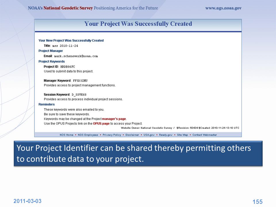
156
UPLOADING DATA TO A PROJECT 2011-03-03 156

157
The second step is to “Upload” data files to your project. At this time, this is done through OPUS-S implying the same restrictions: Your data must be dual frequency pseudorange and phase P1 (or C1), P2, L1 and L2. A minimum 2-hours data span for each submission. A collection rate of 1, 2, 3, 5, 10, 15 or 30 seconds. 2011-03-03 157
, P2, L1 and L2. A minimum 2-hours data span for each submission. A collection rate of 1, 2, 3, 5, 10, 15 or 30 seconds")
158
2011-03-03 158
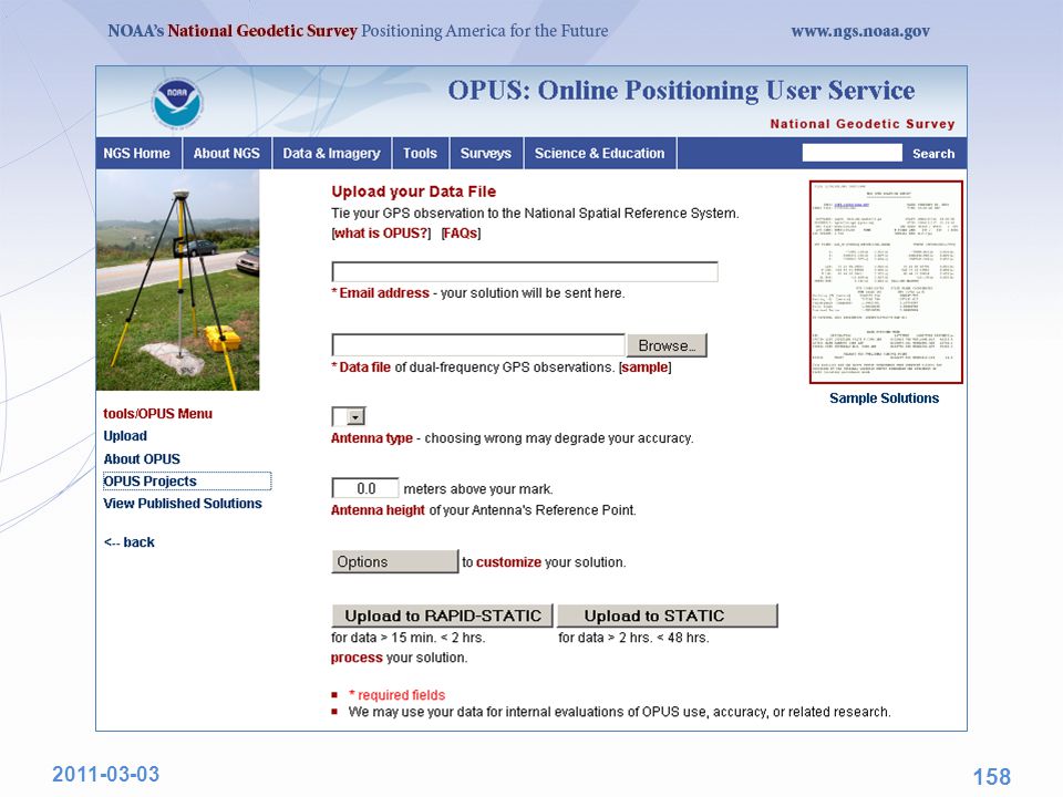
159
2011-03-03 159

160
2011-03-03 160

161
2011-03-03 161

162
2011-03-03 162

163
2011-03-03 163

164
2011-03-03 164

165
2011-03-03 165

166
2011-03-03 166

167
When data are submitted to a project, the OPUS-S results are “quality controlled” using thresholds specified by the project manager. If the results from a data file exceed any of the thresholds, a warning message is sent to the email address entered when the data were submitted. Receiving a warning message does not mean the data will be excluded from your project. That is the project’s decision. However, the data are flagged for easy identification by the project. 2011-03-03 167

168
The highlight is mine. 2011-03-03 168 These preferences can be modified by the project manager.

169
Again, receiving a warning does not mean that the uploaded file is rejected. It only means the file will be flagged. It is still copied to the project and is available for processing. 2011-03-03 169

170
VIEW AND PROCESS A SESSION 2011-03-03 170

171
OPUS-Projects groups the data into sessions. Sessions are groups of site occupations that overlap significantly in time. Note that a site may appear in more than one session. as new data are submitted, the definitions of the sessions may change. Now that some data has been submitted to the project, processing can begin. 2011-03-03 171

172
Let’s switch to a project already loaded with data. The project title is: “ Training data set 1 ” The project keywords are: PROJECT :hrdb86fc MANAGER :ff5d3zmu PROCESS :d_ssvk68 Please note that this is a project used for testing and, so, may not always be in this exact state. Nevertheless, feel free to visit and look around. 2011-03-03 172

173
This time we’ll enter through the Session login on the OPUS- Projects gateway page. 2011-03-03 173

174
2011-03-03 174

175
The banner shows the project’s title and session. The session pull-down menu can be used to select another session to view/work with. 2011-03-03 175

176
The left sidebar holds the controls. 2011-03-03 176

177
The map shows the relative location of the marks in this session or solution, and their status. 2011-03-03 177

178
The right sidebar lists the marks. 2011-03-03 178

179
The table below the map summarizes the status for each mark. 2011-03-03 179

180
The table below at the bottom of the page graphically represents the data availability. 2011-03-03 180

181
Someone working with a session can email other members of the project. 2011-03-03 181

182
Review copies of the reports associated with the session. 2011-03-03 182

183
Or process the session’s data. 2011-03-03 183

184
MANAGE A PROJECT 2011-03-03 184

185
At any time during its lifetime, the manager can review the project’s status and modify details. Once again we’ll use the more interesting project, “ Training data set 1 ” The project keywords are: PROJECT :hrdb86fc MANAGER :ff5d3zmu PROCESS :d_ssvk68 Recall that this is an active test project and, so, may not always be in this exact state 2011-03-03 185

186
2011-03-03 186 The manager’s tasks are sufficiently numerous and varied to warrant a separate login. To begin, enter the project and manager keyword, then click the “Manage” button. The manager’s tasks are sufficiently numerous and varied to warrant a separate login. To begin, enter the project and manager keyword, then click the “Manage” button.

187
2011-03-03 187

188
The menu at the top of the page selects the type of solution or solutions. 2011-03-03 188

189
Because Session processing has been completed, Session and OPUS solutions are now available. Eventually, network adjustments will be available too. 2011-03-03 189

190
The sidebar on the left contains the controls for the manager’s page. 2011-03-03 190

191
The map shows the relative location of the project’s marks. Here, again, the Session solution results are shown, but the OPUS solution results could be selected and displayed instead. 2011-03-03 191

192
The sidebar on the left lists the sites alphanumerically but segregated by project and CORS marks. 2011-03-03 192

193
The summary table at the bottom of the page also provided convenience links to other pages for the project. 2011-03-03 193
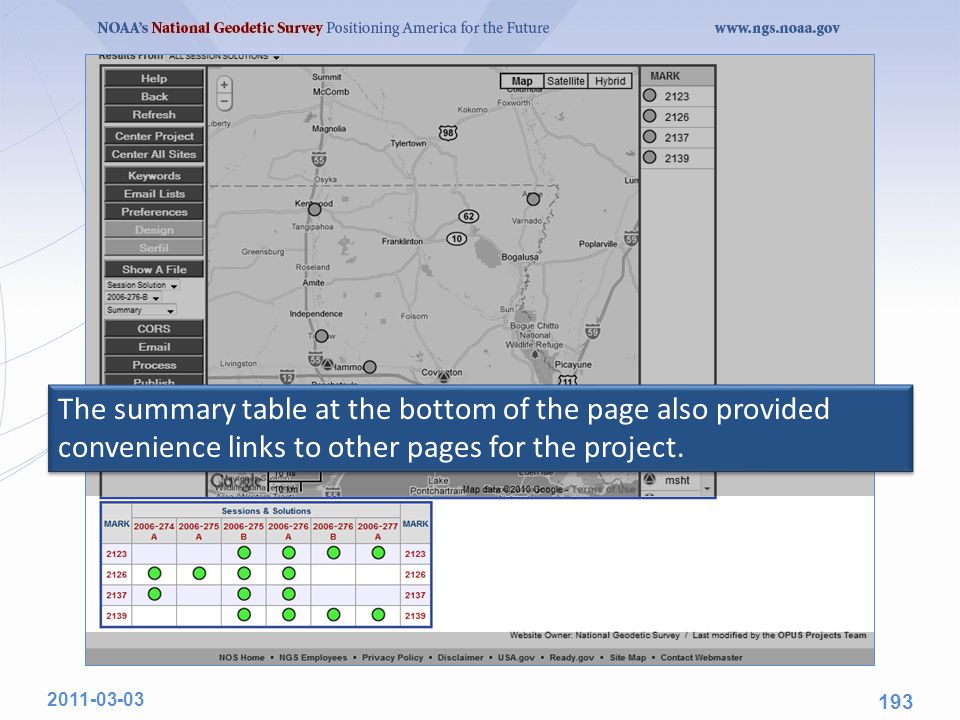
194
The column headers are links to individual Sessions (and later, solutions). 2011-03-03 194
")
195
The row headers are links to individual sites. 2011-03-03 195

196
The Keywords button opens a window with controls to change the project title, project identifier, the manager keyword or the Session keyword. 2011-03-03 196

197
The Email Lists opens a window with controls instructing OPUS- Projects to carbon copy (CC) the manager’s email to others. 2011-03-03 197

198
Preferences allows the manager to customize the defaults for his or her project. 2011-03-03 198

199
A future enhancements will offer tools to design a project, e.g. create hardware lists and deployment schedules, and communicate that information to other project participants. 2011-03-03 199

200
The Serfil button is a placeholder for pending B-, D- and G-record manipulation. These records comprise part of a “bluebook” submission for publication to the integrated database. 2011-03-03 200

201
The reports created during OPUS, Session or Network processing are available through the Show A File controls. The selected files are display in a separate window for printing or saving locally. 2011-03-03 201

202
Additional CORS can be added to a project using the CORS button. 2011-03-03 202

203
A basic email tool for communicating with project participants or the OPUS-Projects staff through the Email button. Note that project reports can be appended. 2011-03-03 203

204
Session solution matrices can be combined and solved creating an adjustment for this project. 2011-03-03 204

205
Using the Publish button, a final network adjustment can be selected, and its results plus the associated mark metadata published. 2011-03-03 205

206
In the near future, tools will be provided to “clean up” a project in preparation for back-up and removal of a project. 2011-03-03 206
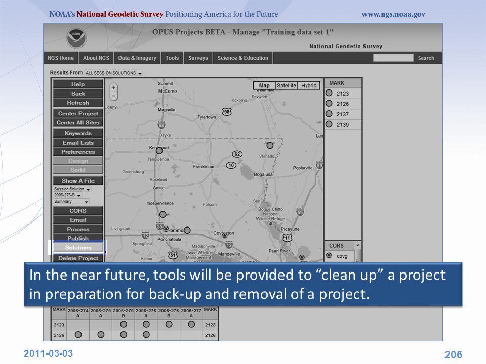
207
Lastly, a request to delete the project can be initiated. This begins a three step confirmation process which, if confirmed at each step, results in the project being deleted. 2011-03-03 207

208
AN INDIVIDUAL SITE PAGE 2011-03-03 208

209
Let’s go to a Mark summary page and examine some results. To navigate to the 2123 page, let’s start on the project manager’s page and click on the Session & Solution table row header for Mark 2123. Similar access is possible from any session page which includes this mark. 2011-03-03 209

210
2011-03-03 210

211
At the top we see the title and controls. 2011-03-03 211

212
Next is a mockup of the datasheet if the mark were to be published. These can be edited by the manager if errors or omissions are found. 2011-03-03 212

213
Below the datasheet mockup is a summary of site metadata by occupation. 2011-03-03 213

214
Below the summary by occupation are the coordinate and status summary tables. 2011-03-03 214

215
And at the bottom are summary plots and tables for comparison of different solutions. The orange parts of the plots indicate regions outside the thresholds set by the project manager. And at the bottom are summary plots and tables for comparison of different solutions. The orange parts of the plots indicate regions outside the thresholds set by the project manager. 2011-03-03 215

216
New Developments for OPUS Dr. Mark Schenewerk Mark.Schenewerk@noaa.gov 816-994-3009

Similar presentations


 for Microcontrollers>")


 Grants Chapter 6.>")

 Geometry (29%)>")

