Download presentation
Presentation is loading. Please wait.

2
Environmental Study Group November 30, 2004 Soil Characterization & Sampling for Effective Surface Reclamation of Saltwater-Impaired Soils

3
Soil Characterization & Sampling for Effective Surface Reclamation of Saltwater-Impaired Soils Gilbert J. Van Deventer, PG, NMCS, REM gil@trident-environmental.com Trident Environmental, PO Box 7624, Midland TX 79708 Office: 432-682-0808 Fax: 432-682-0727 Mobile: 432-638-3106 Website Address: www.trident-environmental.com

4
Sources of information: Remediation of Salt-Affected Soils at Oil and Gas Production Facilities, API Publication No. 4663, Oct. 1997 The Nature and Properties of Soils, by Nyle C. Brady, 1990, 10 th Edition, McMillan Publishing Co. Seeding Rangeland, by Tommy C. Welch, et al, April 1994, Texas Agricultural Experiment Station

5
Soil Characterization Sampling for Effective Surface Reclamation of Saltwater-Impaired Soils Onsite Assessment and Sampling Physical Components Important Soil Properties Soil Horizons Slope and Erosion Susceptibility Drainage Soil Chemistry Water Climate

6
Very important to characterize the soil because we need to know the health, maturity, properties of the soil, and other site conditions if we are to be able to improve or restore the surface. Soil Characterization

7
Soil has four physical components. A typical soil consists of approximately Physical Components Therefore, about 50% of a soil is pore space is occupied by either water or air.

8
Important Soil Properties Texture - relates to the size of individual soil particles (gravel, sand, silt, clay) and how they are apportioned. loam - mixture of sand, silt and clay –clay soils (low permeability); –sandy soils (high permeability); –loams have good drainage –Hard horizon may result in perched water conditions Soil Texture Triangle
; –sandy soils (high permeability); –loams have good drainage –Hard horizon may result in perched water conditions Soil Texture Triangle.")
9
Important Soil Properties Color -- depends on organic content -- makes soil dark Fe-oxide content -- makes soil red Greenish, dark gray, bluish colors or mottles (splotches of light color in dark soil) indicate prolonged wetness. Al-oxides, CaCO3 -- light colors Structure -- shape of aggregates in soil; may influence direction of percolation through soil Soil particles bound in stable aggregates are resistant to erosion and indicative of relatively large and beneficial macropores in the soil. These macropores help the soil efficiently take in rainwater and air which are essential to the survival of most plants and animals.

10
Soil Horizons

11
Soil Profile and Horizons O horizon -- abundant organic matter (OM); dark colored. OM >50% by weight. A horizon -- considered “topsoil” or primary root zone. Has the greatest biological activity and richest in plant nutrients. Internal biotic activities, including plant growth, help bind soil particles together into stable structural units called aggregates. Region from which materials (esp. calcite, iron oxide, clays) are removed (eluviation); lighter color than O, but still contains OM. B horizon -- subsoil material moved from A horizon may accumulate here (illuviation); color depends on presence of iron oxide, calcite, or clay (any of these may be abundant); lighter color than A. Little OM, fewer plant roots, and much less biological activity than topsoil. Usually has the highest proportion of clay which greatly restricts downward migration of water. C horizon -- partially altered parent material, but looks similar to parent material. Contains esentially no OM or illuviation of clay material from above. Has been subjected to chemical weathering by water percolating through the soil. Soil salts, carbonates, and reprecipitated silicates often concentrate and become cemented, further decreasing porosity. R horizon -- (regolith) consolidated geologic bedrock material such as sandstone or limestone. Not considered to have been sufficiently weathered to be described as part of the soil.
 are removed (eluviation); lighter color than O, but still contains OM. B horizon -- subsoil material moved from A horizon may accumulate here (illuviation); color depends on presence of iron oxide, calcite, or clay (any of these may be abundant); lighter color than A. Little OM, fewer plant roots, and much less biological activity than topsoil. Usually has the highest proportion of clay which greatly restricts downward migration of water. C horizon -- partially altered parent material, but looks similar to parent material. Contains esentially no OM or illuviation of clay material from above. Has been subjected to chemical weathering by water percolating through the soil. Soil salts, carbonates, and reprecipitated silicates often concentrate and become cemented, further decreasing porosity. R horizon -- (regolith) consolidated geologic bedrock material such as sandstone or limestone. Not considered to have been sufficiently weathered to be described as part of the soil..")
12
Eluviation - or washing out of carbonates from A horizon to B horizon Illuviation or washing in of material and calcification (CaCO 3 ) from A and C horizon to B horizon Decalcification - removal of calcium from C horizon to B horizon by chemical transformation O A1A1 A2A2 A3A3 B1B1 B2B2 C Example of translocation (movement of materials within the soil profile)
 from A and C horizon to B horizon Decalcification - removal of calcium from C horizon to B horizon by chemical transformation O A1A1 A2A2 A3A3 B1B1 B2B2 C Example of translocation (movement of materials within the soil profile)")
13
The 12 soil orders (soil types) are listed below in the sequence in which they key out in Soil Taxonomy Gelisols - soils with permafrost within 2 m of the surface Histosols - organic soils Spodosols - acid forest soils with a subsurface accumulation of metal-humus complexes Andisols - soils formed in volcanic ash Oxisols - intensely weathered soils of tropical and subtropical environments Vertisols - clayey soils with high shrink/swell capacity Aridisols - CaCO3-containing soils of arid environments with subsurface horizon development Ultisols - strongly leached soils with a subsurface zone of clay accumulation and <35% base saturation Mollisols - grassland soils with high base status Alfisols - moderately leached soils with a subsurface zone of clay accumulation and >35% base saturation Inceptisols - soils with weakly developed subsurface horizons Entisols - soils with little or no morphological development
 are listed below in the sequence in which they key out in Soil Taxonomy Gelisols - soils with permafrost within 2 m of the surface Histosols - organic soils Spodosols - acid forest soils with a subsurface accumulation of metal-humus complexes Andisols - soils formed in volcanic ash Oxisols - intensely weathered soils of tropical and subtropical environments Vertisols - clayey soils with high shrink/swell capacity Aridisols - CaCO3-containing soils of arid environments with subsurface horizon development Ultisols - strongly leached soils with a subsurface zone of clay accumulation and <35% base saturation Mollisols - grassland soils with high base status Alfisols - moderately leached soils with a subsurface zone of clay accumulation and >35% base saturation Inceptisols - soils with weakly developed subsurface horizons Entisols - soils with little or no morphological development")
14
Characteristics of Aridisols Of the twelve soil orders for soil types, Aridisols are probably the most common in west Texas and southeast New Mexico. They are characterized as dry soils generally light in color and low in organic matter. They have a horizon of accumulation of calcium carbonate (calcic), gypsum (gypsic), soluble salts (salic), or sodium (sodic). Except where there is groundwater or irrigation, the soil layers are moist only for short periods of the year. These short moist periods may be sufficient for drought-adapted desert shrubs and annual plants, but much less so for many varieties of perennial grasses or conventional crops. If groundwater is present near the surface, soluble salts often accumulate to levels that most crop plants cannot tolerate. The major land use for Aridisols are for rangeland. They are not generally suitable for cropland as they have a naturally low fertility. Where irrigation water is available, Aridisols can be highly productive however,they must be carefully managed to prevent the accumulation of soluble salts.
, gypsum (gypsic), soluble salts (salic), or sodium (sodic). Except where there is groundwater or irrigation, the soil layers are moist only for short periods of the year. These short moist periods may be sufficient for drought-adapted desert shrubs and annual plants, but much less so for many varieties of perennial grasses or conventional crops. If groundwater is present near the surface, soluble salts often accumulate to levels that most crop plants cannot tolerate. The major land use for Aridisols are for rangeland. They are not generally suitable for cropland as they have a naturally low fertility. Where irrigation water is available, Aridisols can be highly productive however,they must be carefully managed to prevent the accumulation of soluble salts..")
15
Aridisols are further broken down into suborders below:

16
Map of Aridisols in the United States

17
Aridisols have a limited availability of soil moisture for sustained plant growth. The redistribution and accumulation of soluble materials in some layers of the soils are common.

18
Calcid Aridisol with a calcic horizon. The parent materials have a high carbonate (caliche) content.
 content..")
19
Slope and Erosion Susceptibility Erosion is problematic where sloping occurs and potentially severe with slopes > 8% because it results in loss of topsoil Erosion and Slope Controls Rapid establishment of vegetation Berming Terracing Prevention of runon and runoff Leveling Erosion-control fabrics Mulching Contour tillage Hydromulching Biodegradable nets

20
Drainage The ability of a soil to drain is very important especially because salts must be able to move out of the soil root zone in order to remediate the soil. Soil internal drainage is affected by soil texture, pore size distribution, and low permeability layers. Drainage categories as created by the USDA-NRCS are described as: Excessively Drained - Water drains so rapidly that the soil retains relatively little water and plants are frequently in drought stress. Well Drained - Water drains readily but not rapidly allowing for sufficient water to be available for mesophytic plants (plants which require a moderate amount of water) during most of the growing season. Moderately Drained - Water is removed somewhat slowly during some periods of the year. Growth of mesophytic plants is limited. Poorly Drained - Water is removed very slowly and soil is usually wet. Without drainage enhancements, excessive wetness is growth limiting to mesophytic plants. One or more of the following factors: substantial rainfall, minimal slope or depression area, high water table, fine soil texture or low permeability layer, or minimal macropores.
 during most of the growing season. Moderately Drained - Water is removed somewhat slowly during some periods of the year. Growth of mesophytic plants is limited. Poorly Drained - Water is removed very slowly and soil is usually wet. Without drainage enhancements, excessive wetness is growth limiting to mesophytic plants. One or more of the following factors: substantial rainfall, minimal slope or depression area, high water table, fine soil texture or low permeability layer, or minimal macropores..")
21
Soil Chemistry The soil solution (liquid phase of a soil) dissolves and allows other plant nutrients to move toward plant roots. In order for a plant to survive it must have an appropriate amount of each of the plant nutrients as listed below.

22
Soil Chemistry Sources of Nutrients in the Soil Organic matter Most soil nutrients are contained in the soil organic matter. To make these nutrients available the organic matter must be decomposed.. Adsorbed nutrients These are the nutrients that are held on the soil colloid. This is the major source of nutrients for the plants, and is the source that is most easily controlled by man. Soil minerals (includes clay minerals) These are the nutrients that are in the parent materials. These nutrients may become available through weathering, however this is a very slow process.
 These are the nutrients that are in the parent materials. These nutrients may become available through weathering, however this is a very slow process..")
23
Soil Chemistry The salts in saline soils are primarily chloride (Cl - ) and sulfate (SO 4 -2 ) anions that pair with calcium (Ca + ), magnesium (Mg +2 ), sodium (Na + ), and potassium (K + ) cations. Once deposited or released in the soil whether by by natural or man-made means, the salts are brought to or near the surface through micropores by upward-moving water, which then evaporates, leaving the salts behind. Unfortunately, high levels of these salts cannot be tolerated by most crop plants. Detrimental effects on plants stem not only from the high salt contents but also from the level of sodium in the soil, especially in relation to levels of calcium and magnesium. High exchangeable sodium levels are detrimental both physically and chemically. Because of the situations outlined above four primary chemical properties should be measured to characterize salt-affected soils: 1: pH 2: Electrical Conductivity (EC) 3: Exchangeable Sodium Percentage (ESP) 4: Sodium Absorption Ratio (SAR)
 3: Exchangeable Sodium Percentage (ESP) 4: Sodium Absorption Ratio (SAR).")
24
Chemical Properties pH - is a measure of the degree of soil acidity (H + dominant) and alkalinity (OH - dominant). The soil pH controls many chemical and biological functions of soils and plants, especially in relation to nutrient availability for plant growth. In the above diagram the denser the band shade, the greater the availability for that particular plant nutrient, as the shading diminishes nutrient availability decreases.

25
Chemical Properties Electrical Conductivity (EC) - measures the ability of the salt in the soil solution to conduct electricity which correlates indirectly to the concentration of salt in soil. Units are commonly expressed in decisiemens per meter (dS/m). Traditionally, the pH and EC measurements are made in a suspension of soil in water (usually a ratio of 1:1 or 1:2). Although this method is suitable for quick screening in the field, for saline soils it is better to determine pH and EC on a saturated paste of the soil because the moisture content of the paste is sufficiently near that of the soil to make the measured pH more meaningful. Normal (non-saline and non-sodic) soils typically have a pH ranging from 6.5-7.2 pH units and an EC value of 2-6 dS/m.
. Traditionally, the pH and EC measurements are made in a suspension of soil in water (usually a ratio of 1:1 or 1:2). Although this method is suitable for quick screening in the field, for saline soils it is better to determine pH and EC on a saturated paste of the soil because the moisture content of the paste is sufficiently near that of the soil to make the measured pH more meaningful. Normal (non-saline and non-sodic) soils typically have a pH ranging from pH units and an EC value of 2-6 dS/m..")
26
Chemical Properties Exchangeable Sodium Percentage (ESP) - identifies the degree to which the exchange complex is saturated with sodium. Exchangeable sodium - amount of sodium on cation exchange sites or in the soil solution that can participate in the cation exchange process in soil. Cation exchange capacity (CEC) - The number of cation positive charges retained by 100 grams of soil. The CEC is a measurement of the total amount of exchangeable cations that can be held by the soil. Soil clays and organic matter have a relatively large number of negative charge sites which retain cations in dynamic equilibrium with the soil solution. CEC gives an indication of the soils potential to hold plant nutrients. Normal soils typically have an ESP between 13-15
 - The number of cation positive charges retained by 100 grams of soil. The CEC is a measurement of the total amount of exchangeable cations that can be held by the soil. Soil clays and organic matter have a relatively large number of negative charge sites which retain cations in dynamic equilibrium with the soil solution. CEC gives an indication of the soils potential to hold plant nutrients. Normal soils typically have an ESP between")
27
Chemical Properties Sodium Adsorption Ratio (SAR) - is a measure of the relative competitiveness of sodium versus calcium plus magnesium for adsorption onto clay cation exchange sites. It is calculated as follows: Normal soils typically have a SAR between 13-15 One problem with the overdependence on using SAR is that it is merely a ratio of dissolved cations, and is completely unrelated to the total amount of sodium in the soil or the CEC of the soil. This is important because we want to know the total amount of sodium in the soil when calculating the quantity of chemical amendments required to remediate the soil. For this reason, ESP is the preferred over SAR in order to calculate required chemical amendments. ESP ~ SAR when either are <40 (soil at equilibrium)
.")
28
Chemical Properties Saline Soils and Osmotic Potential Soil Dispersion - is the reverse process of aggregation. Dispersion is a detrimental electrochemical process in which soil clay particles repel each other, that is physically move apart, and clog soil pores. Unless soil salinity is also high dispersion will occur in soils having excess sodium. Osmotic Potential - The force which causes dissolved constituents to retain water molecules. Highly saline soil water competes with the plants for water molecules because of the high osmotic potential it creates. Sodic Soils and Soil Dispersion

29
Climate To a great extent, climate determines the type of soil present as it dictates the frequency, duration, and quantity of precipitation and evaporation, as well as the extremes and duration of temperature and wind. After a rainfall, a portion of the rainwater percolates downward through the soil dissolving and carrying soluble salts. During evaporative periods, soil-pore water reverses course and moves back upward through the soil bringing dissolved salts back to the surface. Since salts do not evaporate, they continue to concentrate at the soil surface during evaporation of soil water. These factors have a major impact on the fate and transport of salts in the soil. Most chemical reactions occur at a faster rate with increasing temperature.

30
Water Water is critical to plant growth because it provides the transportation medium in which nutrients are delivered to plants. As stated earlier, a typical soil contains about 25% water in its pore spaces. The pore spaces can be full of water, but rarely contain less than 10% water, even when very dry. Mean Annual Total Precipitation in Texas

31
Salt and Drought Tolerance of Native Grass Plants Common to west Texas Source: Seeding Rangeland, Tommy Welch, et al, April 1994, Texas Agricultural Experiment Station The traditionally accepted objective criteria for remediation of saline and/or sodic soils for all plants has been to decrease the salinity and ESP to <4 dS/m and 15, respectively. However, the presence of naturally saline and sodic environments and the halophytic plants which thrive naturally in these soils indicates that more elevated levels of salts can be an acceptable remediation goal.

32
Law of the Minimum Stave Concept Whether a primary or secondary macronutrient or, a micronutrient, the Law of the Minimum holds: the most growth-limiting nutrient will limit growth, no matter how favorable the nutrient supply of other elements. For example, a deficiency of Fe or Mn (most common in soils containing calcium carbonate) can severely limit plant growth in spite of adequate N, P, and K. This concept also applies to other requirements for active plant growth.
 can severely limit plant growth in spite of adequate N, P, and K. This concept also applies to other requirements for active plant growth..")
33
Assessment and Sampling Activities Compile pertinent information concerning release Draw site map that includes pertinent features, structures, and affected area Collect Soil Samples Test and observe soil sample characteristics

34
Assessment and Sampling Activities Compile pertinent information concerning release -Site identification (Lease No.) and legal location (section, township, range,latitude, longitude, etc.) - Land use (agricultural, grazing, industrial, etc.) - Date of Release (if known) - Amount of release (if known) - Cause of release (if known)
 and legal location (section, township, range,latitude, longitude, etc.) - Land use (agricultural, grazing, industrial, etc.) - Date of Release (if known) - Amount of release (if known) - Cause of release (if known)")
35
Assessment and Sampling Activities Draw site map that includes pertinent features, structures, and affected area__ - Features: roads, fence line, surface water bodies, property lines, etc. - Structures: tank batteries, pipelines, etc. - Horizontal and vertical extent of the salt-affected area - Topography, drainage, and slope characteristics - Native vegetation types (and crops if applicable) - Sample locations and field measured values (pH, EC, chloride, soil type, etc)
 - Sample locations and field measured values (pH, EC, chloride, soil type, etc).")
36
Source: Remediation of Salt-Affected Soils at Oil and Gas Production Facilities, API Publication No. 4663, Oct. 1997 Useful Forms

37
Assessment and Sampling Activities Collect Soil Samples for both Field Measurements and Lab Analysis - Hot spot composites (0-1 ft and 1-2 ft) (Deeper samples may be required) - Avg condition composite (0-1 ft and 1-2 ft) - Background (0-1 ft and 1-2 ft)
 (Deeper samples may be required) - Avg condition composite (0-1 ft and 1-2 ft) - Background (0-1 ft and 1-2 ft)")
39
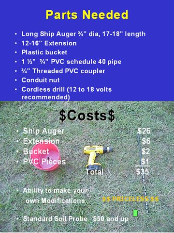
$$ PRICELESS $$

40
Assessment and Sampling Activities Test and observe soil sample characteristics -Determine depth of saltwater penetration -Identify soil horizons and note thickness (particularly topsoil and A horizon. -Identify soil texture, color, structure and quantify sand, silt, clay content - Measure pH, EC, and chloride concentration in the field from samples comprised of a suspension of soil in water (usually a ratio of 1:1 or 1:2). These quick “screening” measurements will be useful in choosing which and how many samples will be submitted for laboratory analysis. - Submit samples for laboratory analysis of CEC, SAR, ESP, OM, cations(Ca, Mg, Na, K, S) and anions (SO 4, Cl), moisture content, pH, and EC.
. These quick screening measurements will be useful in choosing which and how many samples will be submitted for laboratory analysis. - Submit samples for laboratory analysis of CEC, SAR, ESP, OM, cations(Ca, Mg, Na, K, S) and anions (SO 4, Cl), moisture content, pH, and EC..")
42
The moisture content (weight of soil moisture divided by dry weight of soil) at which pH, EC, SAR, ESP values are measured is very important because the ratio of less soluble salts (Ca and Mg) to more soluble salts (Na) increases with increasing moisture content. The saturated percentage represents the maximum moisture content at which dissolved nutrients are available to plants. The saturated percentage is achieved when all soil pores are completely filled with water, but there is no water in excess of that amount. For this reason the method of preparing a saturated paste is recommended to allow measurements of pH, EC, SAR, ESP, and soluble ions. Fortunately, if this is too time consuming and burdensome to do in the field it may be more convenient to have an experienced laboratory do this work for you since they will be performing the analyses anyway. Preparing a saturated paste extract requires allowing the water to equilibrate with the soil for at least an hour and extraction by inducing a vacuum or positive pressure. Saturated Paste Extract

43
Soil Testing Laboratories Texas Plant & Soil Lab, Inc. 5115 W. Monte Cristo Edinburg, TX 78539 956-383-0739 http://www.txplant-soillab.com Texas A&M University Soil, Water and Forage Testing Laboratory 345 Heep Center College Station, TX 77843-2474 979-845-4816 http://soiltesting.tamu.edu/ Texas A&M University Soil & Crop Sciences Department College Station, TX 77843-2474 979-845-7295 http://soildata.tamu.edu/

44
Source: Remediation of Salt-Affected Soils at Oil and Gas Production Facilities, API Publication No. 4663, Oct. 1997

47
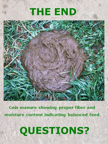
THE END Cow manure showing proper fiber and moisture content indicating balanced feed. QUESTIONS?

Similar presentations


 Parent material (chemical make-up) Life (biological activity)>")