Download presentation
Presentation is loading. Please wait.

1
HOW CAN ENERGY BE TRANSFERRED?
1. CONDUCTION: 2. CONVECTION: 3. ADVECTION: 4. RADIATION:

2
CONDUCTION

3
CONVECTION

4
ADVECTION

5
RADIATION - - + - -

6
Before you leave this section
1. Be able to list the 4 means of energy transfer, and identify the one which transfers all energy into and out of the Earth’s climate system. 2. Be able to describe the means by which energy is transferred in each. 3. Be able to reproduce, with explanation, four concept sketches of the energy transfer mechanisms.

7
What controls the quantity and type of energy the Earth System receives?
How much? What type?

8
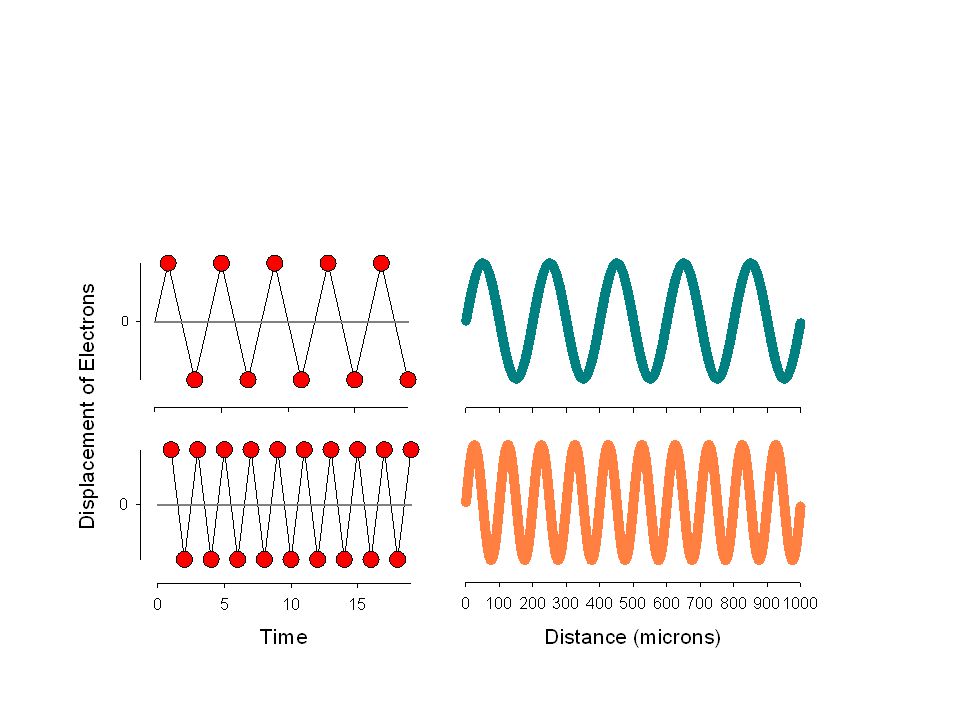
STEFAN-BOLZMAN E= T = d =

9
WEIN Wmax= T =

11
SUN AND EARTH Surface Energy Wmax Temp (Wm-2) (μ) Sun Earth
 (μ) Sun Earth")
14
Before you leave this section
1. Name the laws and understand the physical concepts behind the control that the surface temperature of an object exerts on the quantity and dominant wavelength of Electromagnetic Radiation that it emits. 2. Understand why these two properties of Electromagnetic Radiation are related in the opposite fashion to the temperature of the object. 3. Be aware of what the term “temperature” of an object actually means in terms of energy and the various scales that we use to measure it.

15
PLANCK’S LAW Sun

16
Sun and Earth

17
ELECTRO-MAGNETIC RADIATION SPECTRUM

18
Before you leave this section
1. Graph the types and quantities of radiation being emitted by the Sun and Earth. 2. Know the relative ordering of the various components of the Electro-magnetic Radiation spectrum based on wavelength, including the colors of the visible portions of that spectrum.

19
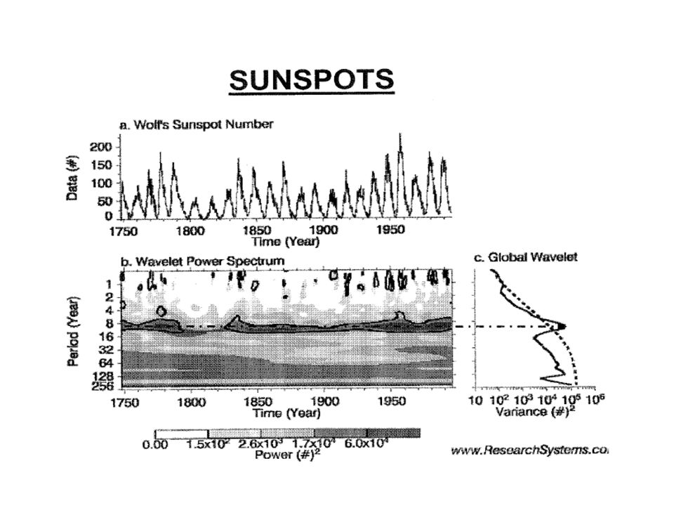
SOLAR CONSTANT

21
Before you leave this section
1. Be able to describe conceptually the derivation of the Solar Constant. 2. Know the numerical value of the Solar Constant and be able to provide a verbal definition. 3. Explain why the Solar Constant may not actually be a true “constant”, but vary periodically with a frequency of about 11 years

22
ZENITH ANGLE AND WHY SHOULD WE CARE?
WHAT IS THE ZENITH ANGLE AND WHY SHOULD WE CARE?

24
Before you leave this section
1. Be able to define the zenith angle. 2. Know what the zenith angle will be at sunrise and sunset and when it will at its minimum. 3. Explain how the zenith angle controls the proportion of the Solar Constant falling on a unit area (square meter) of the Earth’s surface.
 of the Earth’s surface.")
25
Why are some places hot and others cold
Why are some places hot and others cold? Why are some times of the year warmer than others? A. SPATIAL B. TEMPORAL 1. Annual 2. Seasonal 3. Daily

26
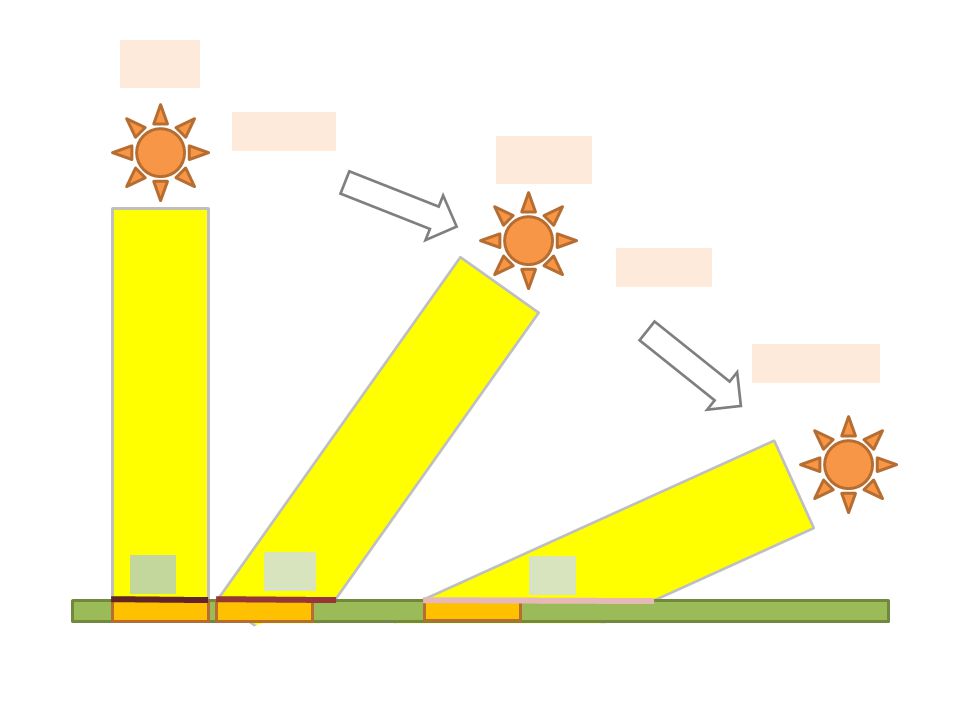
CAN WE QUANTIFY THE EFFECT OF THE ZENITH ANGLE
AND LATITUDE AT NOON? SUN N Equator Center of Earth S

27
CAN WE QUANTIFY THE EFFECT OF THE ZENITH ANGLE
AND LATITUDE AT NOON? SUN N Equator Center of Earth S

28
CAN WE QUANTIFY THE EFFECT OF THE ZENITH ANGLE
AND LATITUDE AT NOON? SUN N Equator Center of Earth S

29
CAN WE QUANTIFY THE EFFECT OF THE ZENITH ANGLE
AND LATITUDE AT NOON? SUN N Equator Center of Earth S

30
Ten parallel rays representing the solar constant (345Wm-2)
SUN

31
Ten parallel rays representing the solar constant (345Wm-2)
SUN

32
Before you leave this section
1. Be able to sketch the relationship between the latitude of a locations and the zenith angle at noon on March and September 21. 2. Be able to explain why the outside of the Earth’s atmosphere at various latitudes will receive varying portions of the solar constant at noon on these days. 3. Understand the trigonometric way in which the zenith angle controls the proportion of the solar constant intercepted. 4. Understand this trigonometric function sufficiently well to be able to explain why large/small zenith angles are associated with varying proportions of the solar constant.

33
HOW DOES THE EARTH’S ORBIT AROUND THE SUN AFFECT INSOLATION?
BYLTS

34
Before you leave this section
1. Be able to identify the dates of the Aphelion and Perihelion. 2. Know approximate Earth-Sun distances at these times, and the average Earth-Sun distance. 3. Understand how to make the appropriate adjustment to the value of the solar constant based upon actual Earth-Sun distance, and be aware of the potential magnitude of this impact.

35
S S U N U N s June 21 N Sun on horizon z = 90° Sun overhead z = 0°
Cancer Equator U Sun overhead z = 0° N Antarctic s Sun on horizon z = 90°

36
S S U N U N December 22 N s WHERE IS THE SUN OVERHEAD AT NOON?
Sun on horizon z = 90° S U N S Arctic Z = >0° = = 23.5° Sun overhead z = 0° U Equator Capricorn N 23.5°S Sun on horizon z = 90° s

37
BOTTOM LINE March and September: Summer (Jun. in N, Dec. in S): Winter (Dec. in N, Jun. in S):
: Winter (Dec. in N, Jun. in S):")
38
Before you leave this section
1. Given the latitude of a location and the time of the year, be able to estimate the zenith angle at noon. 2. Know at which latitude the sun will be directly overhead at the varying times of year. 3. Know the latitudes beyond which the sun is never directly overhead. 4. Know the latitudes beyond which there is at least one day of total darkness (and one of light) and the seasons in which these occur.
 and the seasons in which these occur.")
39
Why do the lengths of Day and Night vary with the seasons? September 21 SUN June 21 December 21 March 21

40
s s s N N N Latitude Degrees North June Solstice Hours of Daylight
Arctic C. Cancer Equator Capricorn Antarctic C. s s s Latitude Degrees North June Solstice Hours of Daylight March/September Equinox December Solstice 90 6 months 12hr 0 hr 80 4 months 70 2 months 66.5 24 hr 50 16 hr 8 hr 40 15 hr 9 hr 30 14 hr 10 hr 20 13 hr 11 hr 10 12.5hr 11.5 hr 12 hr

41
THE BOTTOM LINE 1. 2. 3. 4.

42
Before you leave this section
1. Be able to sketch the orientation of the Earth’s axis of rotation with respect to the Sun during the course of the Earth’s annual revolution around the Sun, and identify the Circle of Illumination. 2. Given key times of year and/or key geographic latitudes be able to estimate the length of daylight. 3. Understand the 4 “bottom line” items with regard to controls on the seasonal and spatial variations in the length of daylight.

43
SEASONAL CHANGES IN INSOLATION WITH LATITUDE

45
GEOGRAPHY MATTERS!

46
Seasonal Changes in Daily Insolation
0° 10°N 30°N 50°N 70°N 90°N

47
PUTTING IT ALL TOGETHER

48
GLOBAL RADIATION REGIMES

49
Before you leave this section
1. Be able to integrate information concerning spatial and temporal scales of variability of insolation. 2. Explain the significance of the Equator, Tropics and Arctic and Antarctic circles in terms of patterns of insolation. 3. Sketch the temporal and spatial variability of insolation at the top of the Earth’s atmosphere , and therefore the basic input to the Earth’s climate system.

50
1. Atmospheric Composition.
WHAT MAKES OUR ATMOSPHERE DISTINCT FROM SPACE? 1. Atmospheric Composition. ALL ATMOSPHERE 1. 2. 3. 4. TRACE GASES 1. 2. 3. 4.

51
WHAT MAKES OUR ATMOSPHERE DISTINCT FROM SPACE?
1. Density of Gases.

52
TORRICELLI

53
Before you leave this section
1. Know the major chemical constituents of the Earth’s atmosphere and the trace gases which will be important in later discussions. 2. Understand the vertical distribution of gases in the Earth’s atmosphere. 3. Understand the concept of Atmospheric Pressure and how this varies vertically in the atmosphere. 4. Know how Atmospheric Pressure is measured.

54
THE GAS LAWS CHARLES’ LAW

55
BOYLE’S LAW

56
“ATMOSPHERIC ENGINE”

57
THE EQUATION OF STATE FOR AN IDEAL GAS. PUTTING IT ALL TOGETHER!
P = R. ρ. T P = R = ρ = T =

58
PRACTICAL APPLICATION
P = R. ρ. T Normal Lapse Rate:

59
Before you leave this section
1. Name and understand the law relating the temperature of a gas and the volume that the gas occupies (at a fixed pressure). 2. Name and understand the law relating the pressure on a gas and the volume that the gas occupies (at a fixed temperature). 3. Be able to follow the linkages by which differences in the supply of insolation ultimately impact atmospheric pressures and movements within the atmosphere. 4. Know the equation of state for an ideal gas and show how it encompasses both Charles’ and Boyle’s Law. 5. Show how this determines the rate at which air cools and warms as it rises and falls respectively.
. 2. Name and understand the law relating the pressure on a gas and the volume that the gas occupies (at a fixed temperature). 3. Be able to follow the linkages by which differences in the supply of insolation ultimately impact atmospheric pressures and movements within the atmosphere. 4. Know the equation of state for an ideal gas and show how it encompasses both Charles’ and Boyle’s Law. 5. Show how this determines the rate at which air cools and warms as it rises and falls respectively.")
61
Before you leave this section
1. Label in the correct vertical sequence, the four thermal layers within the atmosphere, and the boundaries that separate them. 2. Identify those zones which display normal and reverse temperature gradients. 3. Explain why those reverse gradients exist and the gases that are responsible for them. 4. Be able to explain what is believed to cause the “hole in the ozone layer”, and why it might be of environmental concern.

62
WHERE DOES THE INSOLATION GO TO? –
SHORTWAVE RADIATION BUDGET

63
Before you leave this section
1. Understand what is meant by scattering and its impact upon insolation. 2. Identify the means by which energy is absorbed by the atmosphere. 3. Understand the concept of albedo. 4. Delineate the quantities of insolation effected by each atmospheric process. 5. Determine the global average percentages of insolation returned to space, and those stored in the atmosphere and at the Earth’s surface.

64
Albedo: A Geographic Variable?

65
1. 2. 3.
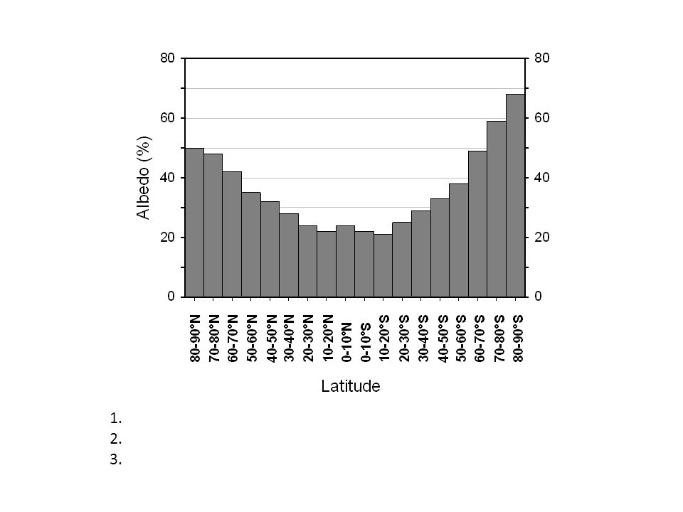
66
Before you leave this section
1. Have an understanding of the albedo of various naturally occurring surfaces. 2. Explain the Pole – Equator differences in albedo. 3. Explain differences in albedo of the Arctic and Antarctic. 4. Identify global zones of rainforest and deserts by their albedo.

67
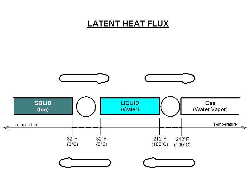
THREE SINKS OF INSOLATION
1. Sensible Heat Flux. 2. Ground Heat Flux. 3. Latent Heat Flux.

70
Before you leave this section
1. Identify the three major sinks to which insolation gets sent in the Earth system, noting the major global ocean-atmosphere features to which these are linked. 2. Understand why the same chemical compound (water) can occur in three very different natural states, and what it is about the behavior of that compound which determines the state. 3. Understand the concept of Latent Heat and how it is stored/released from water in its three natural states without changing the temperature of the water. 4. Know the quantities of energy required/released when water changes states between solid and liquid and liquid and gas – the latent heat of fusion and the latent heat of vaporization.
 can occur in three very different natural states, and what it is about the behavior of that compound which determines the state. 3. Understand the concept of Latent Heat and how it is stored/released from water in its three natural states without changing the temperature of the water. 4. Know the quantities of energy required/released when water changes states between solid and liquid and liquid and gas – the latent heat of fusion and the latent heat of vaporization.")
71
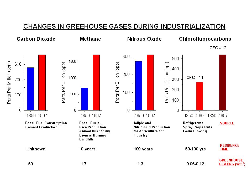
GREENHOUSE EFFECT

74
What Would Temperatures be Without Greenhouse Gases?
SUN EARTH WITH GREENHOUSE ATMOSPHERE EARTH WITHOUT ATMOSPHERE

75
DO OTHER PLANETS HAVE GREENHOUSE EFFECTS?
Just how smart are we in this class? Planet Solar Constant, Wm-2 Planetary Albedo, % Effective Radiating Temperature K Observed Surface Greenhouse Warming Mars 147 15 217(-56°C, -94°F) 220 (-53°C, -87°F) 3 (7°F) Earth 345 31 255 (-18°C, - 9°F 288 (15°C, 66°F) 33 (73°F Venus 653 75 232 (-41°C, -60°F) 700 (427°C, 929°F) 468 (989°F)
 220 (-53°C, -87°F) 3 (7°F) Earth (-18°C, - 9°F. 288 (15°C, 66°F) 33 (73°F. Venus (-41°C, -60°F) 700 (427°C, 929°F) 468 (989°F)")
76
Before you leave this section
1. Understand how greenhouse gases permit shortwave radiation to enter, but prevent long wave radiation from leaving, the atmosphere. 2. Be aware the increases in some greenhouses in the atmosphere and the potential they may have for increasing the amount of energy stored in the Earth’s system, partly manifested by global temperatures. 3. Be able to show the extent of the “Greenhouse Effect” naturally on Earth.

77
LONGWAVE RADIATION BUDGET
Space Atmosphere Surface

78
Before you leave this section
1. Understand how energy is lost from the surface of the Earth to the atmosphere. 2. Be able to explain why the atmosphere itself emits longwave radiation back to the surface of the Earth and to space. 3. Explain why a change in the quantity of greenhouse gases (natural or anthropogenic) in the atmosphere will impact the quantities of direct outgoing longwave radiation and the temperature of the atmosphere before a new equilibrium between incoming and outgoing radiation to the Earth system can be established.
 in the atmosphere will impact the quantities of direct outgoing longwave radiation and the temperature of the atmosphere before a new equilibrium between incoming and outgoing radiation to the Earth system can be established.")
79
NORTHERN HEMISPHERE MERIDIONAL RADIATION
BALANCE AND TRANSFER 0° ~35° 90° Latitude

80
Before you leave this section
1. Describe and explain the meridional (latitudinal) distribution of annual insolation. 2. Describe and explain the meridional (latitudinal) distribution of annual outgoing longwave radiation. 3. Define global zones of surplus and deficit energy balance, and the approximate location of the boundary between the two. 4. Derive the distribution of cumulative net poleward (meridional) transfer of energy across the surface of the globe required to balance out surplus and deficits.
 distribution of annual insolation. 2. Describe and explain the meridional (latitudinal) distribution of annual outgoing longwave radiation. 3. Define global zones of surplus and deficit energy balance, and the approximate location of the boundary between the two. 4. Derive the distribution of cumulative net poleward (meridional) transfer of energy across the surface of the globe required to balance out surplus and deficits.")
81
How is Energy Moved? P = R. ρ. T Tropopause North Pole 2 2 1 South

82
Sir Edmund forgot The rotation of the Earth
North Pole Tropopause South Pole

83
WINDS 45-60°N 30°N Tropopause 0° 30°S 45-60°S

84
SURFACE PRESSURES 45-60°N 30°N Tropopause 0° 30°S 45-60°S

85
Before you leave this section
1. Describe the dominant three dimensional pattern of air circulation within the Earth’s atmosphere. 2. Locate and account for the dominant patterns of surface atmospheric pressure belts on the globe. 3. Identify the global pattern of surface pressure gradients down which the surface winds of the world will flow.

86
CORIOLIS EFFECT Earth Rotating in anti-clockwise direction
Lat. Circum. Velocity 80° km km.hr-1 70° km km.hr-1 60° km km.hr-1 50° km 1078 km.hr-1 40° km 1284 km.hr-1 30° km 1450 km.hr-1 20° km 1574 km.hr-1 10° km 1648 km.hr-1 0° km 1670 km.hr-1 Lat. Circum. Velocity All latitudes rotate with the same ANGULAR VELOCITY (360°/24hrs) 15°.hr-1. However LINEAR VELOCITIES change with latitude.
 15°.hr-1. However LINEAR VELOCITIES change with latitude.")
87
VIEWED FROM ABOVE NORTH POLE
Earth Rotating in anti-clockwise direction

88
Merry-go-round is moving frame of reference
Trees are fixed frame of reference

89
CORIOLIS EFFECT Ferrel’s Law 1. 2.

90
CORIOLIS AS GEOGRAPHIC VARIABLE
Rate of Change of Linear Velocity of Rotation 4000 2000 3000 1000 90°N 80°N 70°N 60°N, Reykjavik 50°N, Southampton 40°N, Philadelphia 30°N, Gainesville 20°N, Guantanamo 10°N, San José 0°, Quito, Equator

91
CORIOLIS AS GEOGRAPHIC VARIABLE
1. 2.

92
CORIOLIS GOES TRUCKING IN A FIXED
FRAME OF REFERENCE, 104! Velocity Distance per unit time Acceleration Change in Velocity per unit time Change in Velocity + Distance - Time Time t = 0

93
CORIOLIS (CB) IN A MOVING
FRAME OF REFERENCE! Velocity Distance per unit time Acceleration Change in Velocity per unit time 8 7 Change in Velocity + Distance 6 5 4 Time Time 3 2 1 t = 0 1 2 3 4 5 6 7 8

94
CORIOLIS PUTS THE PEDAL TO THE METAL IN A MOVING FRAME OF REFERENCE!
Velocity Distance per unit time Acceleration Change in Velocity per unit time 4 Change in Velocity + Distance 3 2 Time Time 1 t = 0 1 2 3 4 5 6 7 8

95
Quantitative Expression
CORIOLIS EFFECT Quantitative Expression Coriolis Effect proportional to: -2Ω . V. Sin (φ). where: Ω = V = Φ =
. where: Ω = V = Φ =")
96
Before you leave this section
1. Know Ferrel’s Law and the apparent direction in which moving objects are deflected from their intended paths in each hemisphere. 2. Understand how (and why) the Coriolis effect varies as a function of latitude. 3. Understand the relationship between the Coriolis effect and the linear velocity of the moving object.
 the Coriolis effect varies as a function of latitude. 3. Understand the relationship between the Coriolis effect and the linear velocity of the moving object.")
97
GLOBAL SURFACE WIND DIRECTIONS
LOW HIGH ~0° ~30°S ~30°N ~45-60°S ~45-60°N ~90°S ~90°N Polar Ferrel Hadley

98
PLUS BONUS CORIOLIS! Polar Ferrel Hadley HIGH LOW ~90°N ~45-60°N ~30°N
~0° ~30°S ~30°N ~45-60°S ~45-60°N ~90°S ~90°N Polar Ferrel Hadley

99
Before you leave this section
1. Be able to construct a diagram of global surface pressures and winds. 2. Be able to designate the correct name to each set of planetary surface winds. 3. Be able to explain why the degree of deflection from the pressure gradient force is greater in some regions of the world than others (and hence the slight variation in nomenclature procedure).
.")
100
CYCLONIC AND ANTICYCLONIC FLOWS
Trust me I am a Doctor! CYCLONE (LOWN) ANTI-CYCLONE NORTHERN SOUTHERN 1) Pressure Gradient 2) Coriolis Effect L H
 ANTI-CYCLONE. NORTHERN. SOUTHERN. 1) Pressure Gradient. 2) Coriolis Effect. L. H.")
101
Before you leave this section
1. Be able to construct predicted air flows around low pressure (cyclones) and high pressure cells (anticyclones) in either hemisphere based simply upon considerations of pressure gradient and Coriolis effect.
 and high pressure cells (anticyclones) in either hemisphere based simply upon considerations of pressure gradient and Coriolis effect.")
102
DIFFERENCES IN OCEANIC AND CONTINENTAL THERMAL PROPERTIES
Differences in Specific Heat. Differences in Latent Heat Flux. Differences in the Penetration of Radiation. Differences in Mixing.

103
SPECIFIC HEAT

104
LATENT HEAT Oceans Continents

105
PENETRATION OF RADIATION
Oceans Continents OCEAN CONTINENT Depth Depth Temperature Temperature

106
MIXING

107
Before you leave this section
1. Be able to explain the concept of Specific Heat and why Oceans and Continents possess such different values. 2. Be able to explain why the partitioning of insolation over continents and oceans is different and the impact that this is likely to have on temperatures. 3. Discuss the impact that varying depths to which insolation can penetrate soil/rock and water will impact the surface temperatures of both global surfaces. 4. Explain the various mechanisms of mixing of surface ocean waters which may act to redistribute energy away from the ocean surface.

108
CAN WE BRING THIS ALL TOGETHER TO EXPLAIN PATTERNS OF GLOBAL
CLIMATE? Our tool kit: 1 2 3 4 5 6

109
90°N SURPLUS/ DEFICIT 45° - 60°N 30°N 0° 30°S 45° - 60°S 90°S

110
90°N SURFACE PRESSURE BELTS 45° - 60°N 30°N 0° 30°S 45° - 60°S 90°S

111
90°N OCEAN\ CONTINENT CONTRAST 45° - 60°N 30°N 0° 30°S 45° - 60°S 90°S

112
90°N OCEAN\ CONTINENT CONTRAST 45° - 60°N 30°N 0° 30°S 45° - 60°S 90°S

113
90°N PRESSURE CELLS 45° - 60°N 30°N 0° 30°S 45° - 60°S 90°S

114
Pressure Gradient

115
90°N SURFACE WINDS 45° - 60°N 30°N 0° 30°S 45° - 60°S 90°S

116
HIGH LOW HIGH HIGH HIGH LOW HIGH LOW 90°N SURFACE OCEAN CURRENTS 45° -

117
REALITY

118
THE SOUTHERN OCEANS 0° 30°S 45° - 60°S 90°S

119
Before you leave this section
1. Be able to combine the elements of the class thus far to define annual average pressure belts and cells over the major ocean basins and continents of the world using a simple two-continent, one ocean models. 2. Through the use of sketches be able to define the location and nature of major ocean currents (cold and warm) using the same simple model . 3. Identify the major global exceptions to these generalizations, and be able to explain why and how they differ.
 using the same simple model . 3. Identify the major global exceptions to these generalizations, and be able to explain why and how they differ.")
120
90°N June 21 Boreal Summer 45° - 60°N 30°N 23.5°N 0° 23.5°S 30°S

121
90°N June 21 Boreal Summer 45° - 60°N 30°N 23.5°N 0° 23.5°S 30°S

122
90°N Dec. 21 Boreal winter 45° - 60°N 30°N 23.5°N 0° 23.5°S 30°S

123
90°N Dec. 21 Boreal Wnter 45° - 60°N 30°N 23.5°N 0° 23.5°S 30°S

124
GLOBAL SURFACE PRESSURES JULY 2010

125
GLOBAL SURFACE PRESSURES JANUARY 2010

126
Before you leave this section
1. With the aid of the simple concept sketches, describe and explain the physical reasoning for the shifts in boreal pressure belts and wind directions in the northern hemisphere summer. 2. With the aid of the simple concept sketches, describe and explain the physical reasoning for the shifts in boreal pressure belts and wind directions in the northern hemisphere winter.

127
SINKS OF INSOLATION REVISITED
1. 2. 3.
128
ENERGY TRANSFER REVISITED
1. 2. 3.
129
TRANSFER OF LATENT HEAT

130
HOW TO EXTRACT LATENT HEAT FROM WATER VAPOR.

131
HOT FLORIDA AND AIR CONDITIONER!

132
ENGLAND!

133
TOO COLD TO SNOW?

134
PUT ON THE FURNACE!

135
GLOBAL AIR CONDITIONERS???
Q. A.

136
Tropopause HIGH LOW LOW HIGH HIGH HIGH LOW LOW LOW HIGH HIGH HIGH LOW
45-60°N LOW LOW 30°N HIGH HIGH HIGH Tropopause 0° LOW LOW LOW 30°S HIGH HIGH HIGH LOW LOW 45-60°S HIGH

137
INTER-TROPICAL CONVERGENCE ZONE

139
Tropopause HIGH LOW LOW HIGH HIGH HIGH LOW LOW LOW HIGH HIGH HIGH LOW
45-60°N LOW LOW 30°N HIGH HIGH HIGH Tropopause 0° LOW LOW LOW 30°S HIGH HIGH HIGH LOW LOW 45-60°S HIGH

141
GLOBAL FURNACES??? Q. A.

142
Tropopause HIGH LOW LOW HIGH HIGH HIGH LOW LOW LOW HIGH HIGH HIGH LOW
45-60°N LOW LOW 30°N HIGH HIGH HIGH Tropopause 0° LOW LOW LOW 30°S HIGH HIGH HIGH LOW LOW 45-60°S HIGH

144
Tropopause HIGH LOW LOW HIGH HIGH HIGH LOW LOW LOW HIGH HIGH HIGH LOW
45-60°N LOW LOW 30°N HIGH HIGH HIGH Tropopause 0° LOW LOW LOW 30°S HIGH HIGH HIGH LOW LOW 45-60°S HIGH

146
MORE GLOBAL AIR CONDITIONERS???
Q. A.

147
CENTRAL AIR (Heating and Cooling)!!
Ocean Continent

148
FLORIDA Gulf of Mexico North Atlantic

150
CALIFORNIA North Pacific

152
Before you leave this section
With the aid of the simple concept sketches, be able to describe and explain the physical reasoning for the following: 1. The distribution of global precipitation, specifically the equatorial and mid-latitude precipitation belts. 2. The role of topography in modifying global precipitation patterns. 3. The distribution of global deserts. 4. The role of surface ocean currents in modifying the global distribution of precipitation and deserts.

Similar presentations