Download presentation
Presentation is loading. Please wait.

2
Volcanoes

3
Welcome to Washington - the 42 nd State

4
Why are we in Washington? How are volcanoes different in Washington than Hawaii?

5
The evergreen state

9
Space needle – built for the 1962 World’s Fair

10
Pike’s place market – you can get anything from fish to tulips

11
Honey – I’m home

12
Cascade Range We’re in Washington because of the volcanoes in the Cascade Range

15
Historic 1847 painting

16
The tiny Juan de Fuca plate is subducting under the North American Plate – this created the chain of volcanoes

17
What mountains make up the Cascade Range Mount Thielsen Mount Stuart Mount Lassen Mount Shasta Mount Rainier Mount St. Helens

18
Mount ThielsenMount Thielsen: Mount Thielsen is one of the "pointiest" mountains in the world, but the firm rock of the summit pinnacle makes it an easy climb.

19
Mount Stuart is a massive rocky pyramid that utterly dominates the view from Longs Pass.

20
Lassen PeakLassen Peak: The volcanic moonscape of the summit crater.

21
Mt. Shasta and the prominent "heart", surrounded by narrow snowfields, from the town of Mt. Shasta.

22
The massive, icy form of Mount Rainier in the classic view from the Paradise Inn area on the south side of the mountain.

23
Mt. St. Helens before the blast

24
And after – what happened

25
Mt. St. Helens is on an ocean-continent subduction boundary (the Juan de Fuca plate is subducting under the N. American plate). Mt. St. Helens is an active stratovolcano.
. Mt. St. Helens is an active stratovolcano..")
26
May 18, 1980

31
Realizing their dangerous situation, the pilot put the plane into a steep dive to gain speed, and thus was able to outrun the rapidly mushrooming eruption cloud that threatened to engulf them. The Stoffels were fortunate to escape, and other scientists were fortunate to have their eyewitness account to help unscramble the sequence and timing of the quick succession of events that initiated the May 18 eruption. The collapse of the north flank produced the largest landslide-debris avalanche recorded in historic time. Detailed analysis of photographs and other data shows that an estimated 7-20 seconds (about 10 seconds seems most reasonable) elapsed between the triggering earthquake and the onset of the flank collapse. During the next 15 seconds, first one large block slid away, then another large block began to move, only to be followed by still another block. The series of slide blocks merged downslope into a gigantic debris avalanche, which moved northward at speeds of 110 to 155 miles an hour. Part of the avalanche surged into and across Spirit Lake, but most of it flowed westward into the upper reaches of the North Fork of the Toutle River. At one location, about 4 miles north of the summit, the advancing front of the avalanche still had sufficient momentum to flow over a ridge more than 1,150 feet high. The resulting hummocky avalanche deposit consisted of intermixed volcanic debris, glacial ice, and, possibly, water displaced from Spirit Lake. Covering an area of about 24 square miles, the debris avalanche advanced more than 13 miles down the North Fork of the Toutle River and filled the valley to an average depth of about 150 feet; the total volume of the deposit was about 0.7 cubic mile. The dumping of avalanche debris into Spirit Lake raised its bottom by about 295 feet and its water level by about 200 feet. - NEXT PAGE - - NEXT PAGE - Schematic cross sections of Mount St. Helens showing the cryptodome of magma that produced the bulge and the three major blocks that collapsed to form the debris avalanche (After USGS Professional Paper 1250). Compare with photographs in "The Catastrophic First Minute."
 elapsed between the triggering earthquake and the onset of the flank collapse. During the next 15 seconds, first one large block slid away, then another large block began to move, only to be followed by still another block. The series of slide blocks merged downslope into a gigantic debris avalanche, which moved northward at speeds of 110 to 155 miles an hour. Part of the avalanche surged into and across Spirit Lake, but most of it flowed westward into the upper reaches of the North Fork of the Toutle River. At one location, about 4 miles north of the summit, the advancing front of the avalanche still had sufficient momentum to flow over a ridge more than 1,150 feet high. The resulting hummocky avalanche deposit consisted of intermixed volcanic debris, glacial ice, and, possibly, water displaced from Spirit Lake. Covering an area of about 24 square miles, the debris avalanche advanced more than 13 miles down the North Fork of the Toutle River and filled the valley to an average depth of about 150 feet; the total volume of the deposit was about 0.7 cubic mile. The dumping of avalanche debris into Spirit Lake raised its bottom by about 295 feet and its water level by about 200 feet. - NEXT PAGE - - NEXT PAGE - Schematic cross sections of Mount St. Helens showing the cryptodome of magma that produced the bulge and the three major blocks that collapsed to form the debris avalanche (After USGS Professional Paper 1250). Compare with photographs in The Catastrophic First Minute. .")
33
Graphic shows the amount of material displaced by the 1980 blast

35
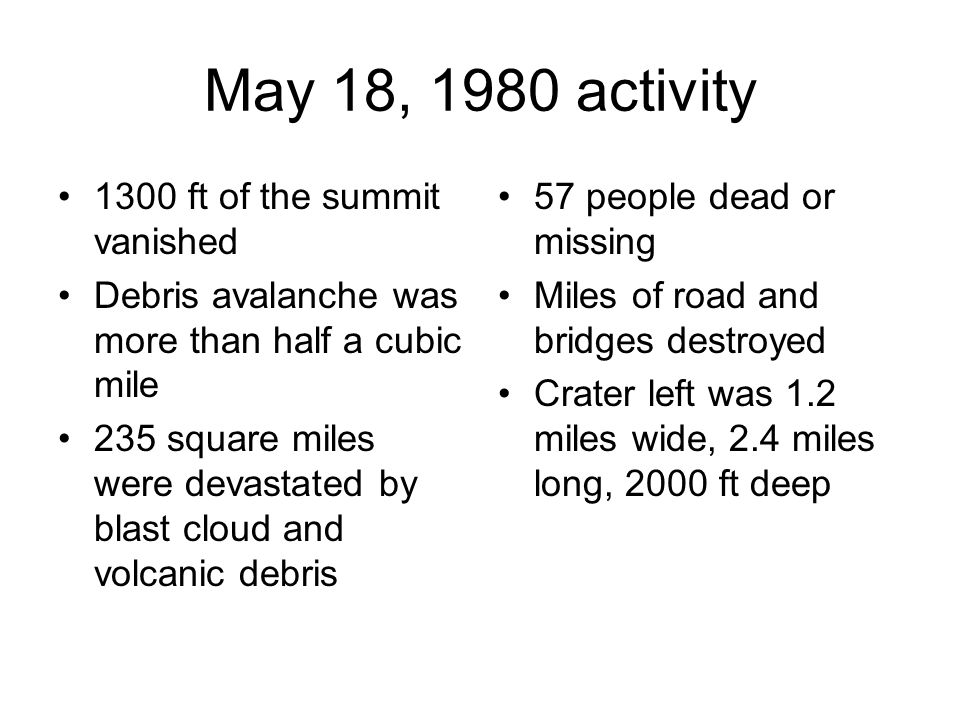
May 18, 1980 activity 1300 ft of the summit vanished Debris avalanche was more than half a cubic mile 235 square miles were devastated by blast cloud and volcanic debris 57 people dead or missing Miles of road and bridges destroyed Crater left was 1.2 miles wide, 2.4 miles long, 2000 ft deep

39
Mudflow-damaged house along the Toutle River.

40
Downed trees from blast – note people in lower right

59
Another view of lahar

62
January 2007

64
25 years after the eruption

65
Current eruption over The nearly three and a half years of eruption at Mount St. Helens is over for now and on July 10, 2008, scientists lowered the volcano alert level from Advisory to Normal and the aviation color code from Yellow to Green. Mount St. Helens reawakened in October 2004 when four explosions blasted steam and ash up to 10,000 feet above the crater. Growth of this lava dome continued until late January 2008. Five months have passed with no signs of renewed eruptive activity. Earthquakes, volcanic gas emissions, and ground deformation are all at levels seen before the eruption began.

66
Next eruption?

67
Just in case

Similar presentations


 Erupted on the morning of May 18 th 1980, after being inactive for over 120 years. Caused by the.>")


 high The mountain is 6 miles (9.5.>")


 convergent boundaries = plates converge (come together) transform boundaries = plates slide past each.>")