Download presentation
Presentation is loading. Please wait.

1
A Bureau of Land Management Field Office Approach

2
Carlsbad Field Office

3
Current Office Processes Segregated review Data isolation Physical Nature of Information Paper maps Analog files and folders Loss of Institutional Knowledge Retirements Reactionary Mode of GIS Professionals Can you make me a Map?

4
Project Folder Analysis DATA 10 days Analysis DATA 9 days Analysis DATA 18 days Analysis DATA 20 days Wildlife Soil-Air- Water Archaeology Recreation Range Analysis DATA 15 days Example

7
Physical Nature of Information Realty Range Archaeology

8
Physical Nature of Information Minerals Archaeology Wildlife

9
Epidemic loss of Information Retirements Relocations Dysfunction Workflow How was this data collected and used? Two steps forward, three steps back Functioning Workflow Resource Data Dysfunctional Workflow Resource Data

10
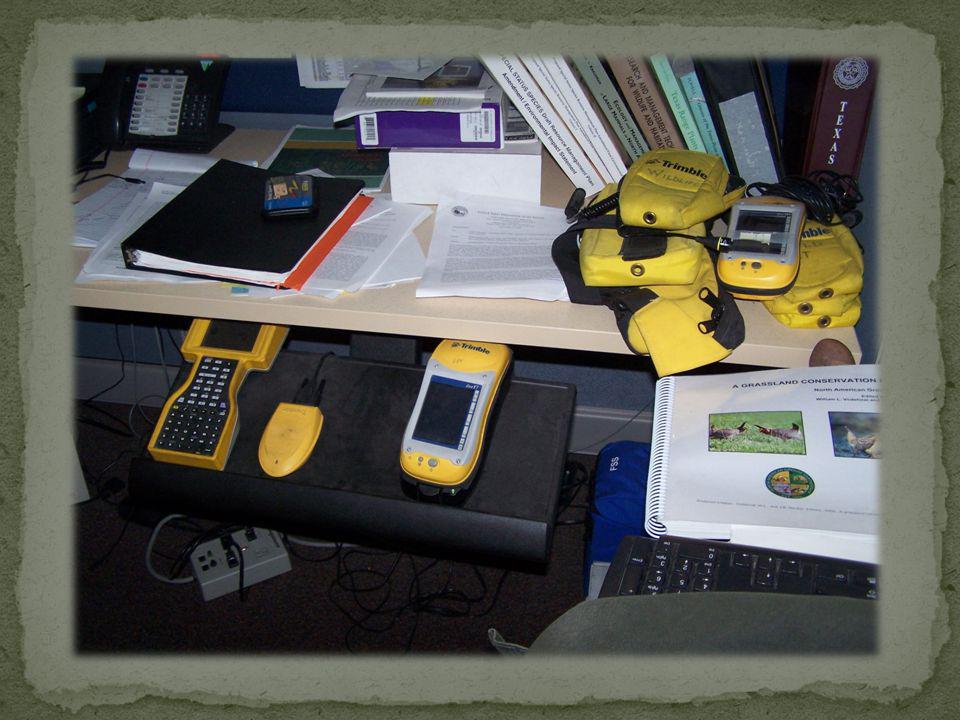
Reactionary Mode of GIS Pictures of maps and plotting devices

11
November 2005 Field Office Archaeologists High Workload 1,500 NEPA projects High Turn Over 7 months Can GIS Help?

12
Project Folder submitted to Archaeology NEPA documents matched up with survey and site maps Wait For Report NO Yes Record of review Federal Surface/Split Estate Identify Surface owner Arch review for NEPA adequacies NO Yes Contact Archaeologist Positive Negative Verify Notify Client Eligible Not Determined Not Eligible Adverse Effect No Adverse Effect No effect Determination of Effect Test/Move/Abandoned Build conditions of approval If necessary Mitigation strategy sent to State Historic Preservation Officer (SHPO) If Bureau of Reclamation or State of New Mexico - Consult with Agency Archaeologist BLM to implement Surface owners concerns Sign Off 1 2 2A 35 6 6A6A 5A 5A15A2 5B5B 6A1 6 B1 6 B2 6 B3 6B4 a 6B4 b 6B4 c 6B5a 6B5b 6B5c 6B5a1 6B1a 6B1b 8 9 Build conditions of approval to achieve no effect Determination of Eligibility 6B46B4 Addendum report or sundry 5B 6B5c1 Wait For Report Review Complete Field check Negative/Positive Arch Report received Database and analog Site maps updated Database and analog Site maps updated Field check 4 7 Needed Spatial Information Archaeological Report
 If Bureau of Reclamation or State of New Mexico - Consult with Agency Archaeologist BLM to implement Surface owners concerns Sign Off 1 2 2A A6A 5A 5A15A2 5B5B 6A1 6 B1 6 B2 6 B3 6B4 a 6B4 b 6B4 c 6B5a 6B5b 6B5c 6B5a1 6B1a 6B1b 8 9 Build conditions of approval to achieve no effect Determination of Eligibility 6B46B4 Addendum report or sundry 5B 6B5c1 Wait For Report Review Complete Field check Negative/Positive Arch Report received Database and analog Site maps updated Database and analog Site maps updated Field check 4 7 Needed Spatial Information Archaeological Report")
13
Documenting Business Requirements Office ProcessesDataWorkload Data – Workflow interactions NEPA related projects are routed to resource specialists for internal review. Arch report contains scale sensitive information that is transferred to 7.5 topographic maps (sites & surveys). Archaeologists are responsible for determining if arch resources would be impacted by activity. Arch site boundaries information is used to determine location. Archaeologist review last. Topographic maps have been used since the late 70s and are difficult to read and make determinations. Due to increased Oil/Gas activity, resource staff spends large percentage of time reviewing projects Arch survey information is used to determine if adequate survey has been completed. Waiting for arch survey reports to be submitted to BLM by contract archaeologists. Topographic maps have been lost, stolen or misplaced. Large amount of time is spent manually matching up Arch reports with NEPA projects. Multiple maps exist for both project data and site boundaries. Certain areas of field office contain multiple topographic maps for same area (up to 7). If Archaeologist had issue with project, location was relocated and review process began again. Arch data is considered proprietary and maps are locked in cabinets from other BLM staff. Approximately 1,100 reports are gathered yearly. Maps are degraded and updated daily as new information becomes available.
. Archaeologists are responsible for determining if arch resources would be impacted by activity. Arch site boundaries information is used to determine location. Archaeologist review last. Topographic maps have been used since the late 70s and are difficult to read and make determinations. Due to increased Oil/Gas activity, resource staff spends large percentage of time reviewing projects Arch survey information is used to determine if adequate survey has been completed. Waiting for arch survey reports to be submitted to BLM by contract archaeologists. Topographic maps have been lost, stolen or misplaced. Large amount of time is spent manually matching up Arch reports with NEPA projects. Multiple maps exist for both project data and site boundaries. Certain areas of field office contain multiple topographic maps for same area (up to 7). If Archaeologist had issue with project, location was relocated and review process began again. Arch data is considered proprietary and maps are locked in cabinets from other BLM staff. Approximately 1,100 reports are gathered yearly. Maps are degraded and updated daily as new information becomes available..")
14
Documenting Business Requirements Add screen shot of current Archaeology GIS

15
Documenting Business Requirements Add screen shot of current Arch report in GIS

16
Documenting Business Requirements

17
Developing a Field Office Needs Assessment ESRI Design strategy Requirements GIS Planning Methodology Stages 1-4 BLM Field office constraints Objectives Field level assessment Process Components

18
Assessment Stages-People Assessment Components-Procedure

19
Manager Support Assessment Team Resource Collaboration

20
One-on-One Manager Interaction Introduce project goals and review documentation Manger Meeting Approval for Needs Assessment Document Comments, Concerns & Issues The process needs to remain transparent to entire staff Public Display of Support Will lay the foundation for assessment process

21
One-on-One Resource interaction Considered a continuation for support and approval Review project goals, workload, resource responsibilities Document comments, concerns and Issues Available manager input Document any new input or concerns

22
Team Interaction Team meeting Project goals and objectives established Roles & Responsibilities Lead and Support roles Document comments, concerns & Issues

23
Identify Resource Functions Map out Workflows Gather remaining components Review Process

24
Resource Overview Summary of resource or program functions and procedures To be written by GIS professional Major Functions Identify and document all resource functions Resource Staff Identification of positions Current Hardware and Software

25
Level of Technological Usage Description Browse Map Creation Query and Display Map Overlay Spatial Modeling Current Capabilities Resource Data Maps, files, databases, GIS data, spreadsheets Summaries To be written by GIS professional Workflow Gain insight on interactions between resource staff and information.

27
Matrix Detailed information on individual steps within workflow Process steps Descriptions Data source Data Input Time Occurrence Frequencies Output

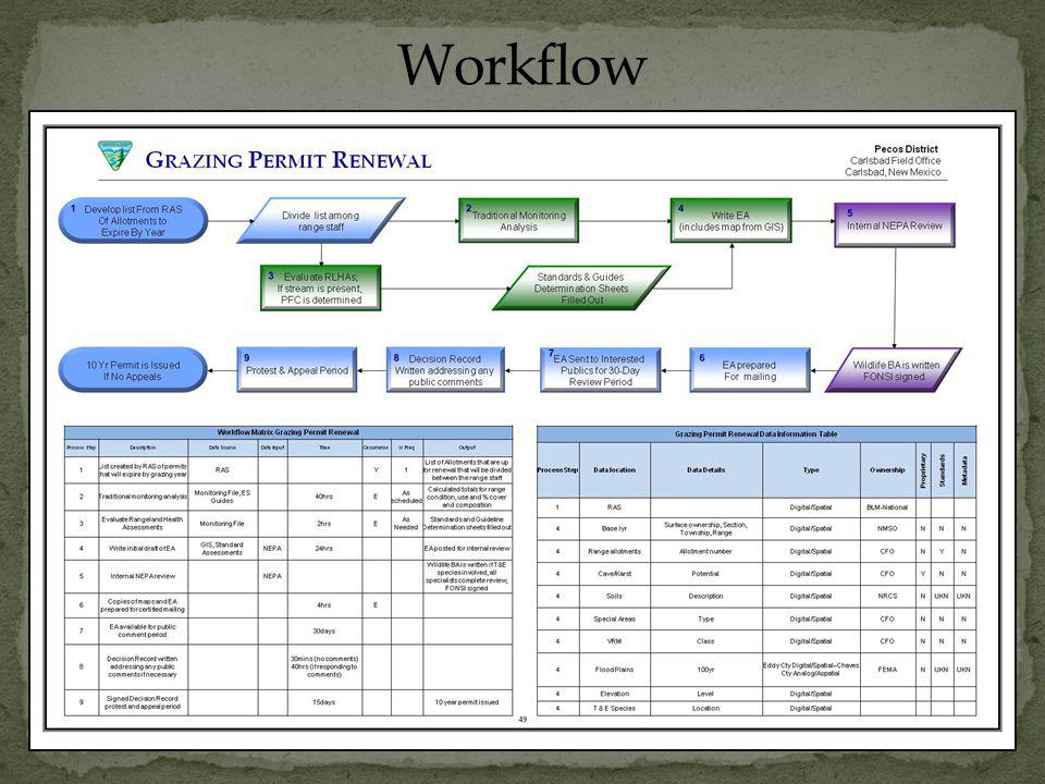
28
Workflow Matrix Grazing Permit Renewal Process Step DescriptionData Source Data Input TimeOccurrenceYr FreqOutput 1 List created by RAS of permits that will expire by grazing year RAS Y1 List of Allotments that are up for renewal that will be divided between the range staff 2Traditional monitoring analysisMonitoring File, ES Guides 40hrsE As scheduled Calculated totals for range condition, use and % cover and composition 3 Evaluate Rangeland Health Assessments Monitoring File 2hrsEAs Needed Standards and Guideline Determination sheets filled out 4Write initial draft of EA GIS, Standard Assessments NEPA24hrs EA posted for internal review 5Internal NEPA review NEPA Wildlife BA is written if T&E species involved, all specialists complete review, FONSI signed 6 Copies of maps and EA prepared for certified mailing 4hrsE 7 EA available for public comment period 30days 8 Decision Record written addressing any public comments if necessary 30mins (no comments) 40hrs (if responding to comments) 9 Signed Decision Record protest and appeal period 15days 10 year permit issued
 40hrs (if responding to comments) 9 Signed Decision Record protest and appeal period 15days 10 year permit issued")
29
Data List Identify data used during workflow process Process step Data Location Data Details Type Ownership Proprietary Standards Metadata

30
Grazing Permit Renewal Data List Process Step Data locationData DetailsTypeOwnership Proprietary Standards Metadata 1RAS Digital/SpatialBLM-National 4Base.lyr Surface ownership, Section, Township, Range Digital/SpatialNMSONNN 4Range allotmentsAllotment numberDigital/SpatialCFONYN 4Cave/KarstPotentialDigital/SpatialCFOYNN 4SoilsDescriptionDigital/SpatialNRCSNUKN 4Special AreasTypeDigital/SpatialCFONNN 4VRMClassDigital/SpatialCFONNN 4Flood Plains100yr Eddy Cty Digital/Spatial--Chaves Cty Analog/Aspatial FEMANUKN 4ElevationLevelDigital/Spatial 4T & E SpeciesLocationDigital/Spatial

31
Assessment Stages Manager Support Resource Collaboration Assessment Team Resource Interviews Assessment Components Resource Overview Major functions Resource Staff Current Hardware & Software Level of Technological Usage Current Available Capabilities Existing Resource data Workflow Summaries Workflows Matrix Data List

33
O BJECTIVE To investigate and develop resource and field level financial analysis for the Carlsbad Field Office (CFO). U TILIZED D OCUMENTATION Final Business Case For The Development Of A Statewide GIS Utility Geospatial Services Model Building a Business Case for Geospatial Information Technology BLM Geospatial Services Strategic Plan

34
O PERATIONAL AND E FFICIENCY B ENEFITS Expected gains in efficiency and productivity Less time – Less expense C ONSTRUCTED T ABLE Resource functions 5 value categories Description and benefits Time reduction

35
C OLLATERAL V ALUE B ENEFITS Intangible benefits Financial in nature – Best measured in non-financial terms Supports operational and efficiency benefits C ONSTRUCTED T ABLE Resource functions 5 value categories Description and benefits Resource functions (internal/external)
")
36
V ALUE C ATEGORIES AND M EASURES FOR C OLLATERAL B ENEFITS 5 value categories Measures – address benefits for value categories Listed with current status and targets What do users want?

37
C OLLATERAL V ALUE B ENEFITS AND GIS M ILESTONES Based on the Value Categories and Measures for Collateral Benefits table 5 value categories Measures and Targets Qualitative Rating Scale Milestones Where are we where do we want to be and how long will it take us to get there?

38
F INANCIAL A NALYSIS I NVESTIGATION All documentation at this point is under investigation for further use to the Carlsbad Field Office.

Similar presentations


 Changes Iowa Medicaid Enterprise October 14, 2008.>")


 and>")


 Presentation by - Membertou Geomatics Solutions Mikmaq Ecological Knowledge Studies.>")


 and Oil.>")


