Download presentation
Presentation is loading. Please wait.

1
YEAR 7 GEOGRAPHY 4 FIGURE GRID REFERENCES INTRODUCTORY

2
This activity will help you to support your child to...
Read and write four-figure grid references using an Ordnance Survey map.

3
Map courtesy of the Ordnance Survey-
Read this explanation... Ordnance Survey maps are covered by numbered grids. These help us pinpoint places more easily. Map courtesy of the Ordnance Survey-

4
If a place is given a number, 4323, it is called a grid reference.
The first two digits (43) are called the Eastings, they found along the bottom and top of a map. The second two digits (23) are called the Northings, they are found along the side of the map. Read this explanation...
 are called the Eastings, they found along the bottom and top of a map. The second two digits (23) are called the Northings, they are found along the side of the map. Read this explanation...")
5
To find the grid reference 4421-
First place a finger on line 44 of the Eastings. Place a second finger on line 21 of the Northings. Draw your fingers together, the square you are looking for is North-East of where the two lines cross. Read this explanation...

6
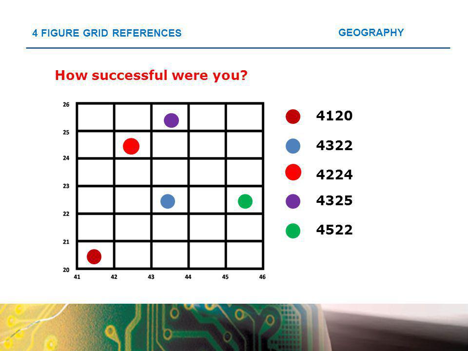
Note the four figure grid references of the five coloured dots below.
Try this activity...

7
How successful were you?
4120 4322 4224 4325 4522
8
Challenge your child and take their learning to the next level...
The Ordnance Survey Map Zone has a number of interactive activities for developing basic map skills. Click on the logo below.

Similar presentations

 North Downs at OS 1:25,000 Explorer map No 171 Figure 2 Map centred at GR TQ444569.>")


 of a landscape or area of a country 3-D maps: google earth, streetmap etc It could be anything from a sketched.>")