Download presentation
Presentation is loading. Please wait.

1
Integrated Monitoring in Bird Conservation Regions (IMBCR) Program
Jay Carlisle Intermountain Bird Observatory, Boise State University With help from Chris White, Nick Van Lanen, and Christian Meny

2
NABCI “Opportunities for Improving Avian Monitoring”
Goal 1: Integrate monitoring into bird management and conservation practices. Goal 2: Coordinate monitoring programs among organizations and integrate them across spatial scales. Goal 3: Increase the value of monitoring information by improving statistical design. Goal 4: Maintain bird population monitoring data in modern data management systems. 2

4
Sampling Frame Bird Conservation Regions (BCRs) Ecologically distinct regions in North America with similar bird communities, habitats, and resource management issues.
 Ecologically distinct regions in North America with similar bird communities, habitats, and resource management issues.")
5
Overview of the Design BCR is the sampling frame Not road biased
Grid-based, scaleable sampling design Stratified with fixed (not ephemeral) strata Spatially balanced sample selection Increased precision – reduces variance Not road biased Collect site characteristics at the sampling points For evaluating changes in populations 5
 strata. Spatially balanced sample selection. Increased precision – reduces variance. Not road biased. Collect site characteristics at the sampling points. For evaluating changes in populations. 5.")
6
Stratification Strata are defined by areas to which we want to make inferences Strata are based on fixed attributes Federal/state land ownership Elevation, latitude, soil type, eco-region All vegetation types available for sampling Flexible Each state within the BCR and each BCR within a state can be stratified differently depending on local needs

8
IMBCR sampling design allows inference at multiple spatial scales:
Land Ownership Management Units within units Sampling locations selected such that all scales of inference are sampled randomly and in a spatially balanced fashion X

9
Sample Unit Selection Spatially balanced sample distribution (GRTS)
All sample units ranked within each strata in selection order Not Road biased

10
BCR & Management Boundaries In Idaho
Using BCR’s as the bounds of the sampling frame invites expanding partnerships in an approach that would be coordinated for North America. In this example and out pilot study, we will focus on BCR 16 and specifically the Colorado and Wyoming Portions of BCR 16. 3 US Forest Service Regions would be involved in BCR 16 monitoring increasing partnership collaboration complexity but also hopefully also increasing consistent funding and higher level commitment to the project. 7 states (Co, Ut, Nm, Az and parts of Nv, Id, and Wy) There may be opportunities to work with other entities (NABCI, JVP, ABC (multi-state grant)) to coordinate regionally and gain efficiencies. Cost Sharing
 There may be opportunities to work with other entities (NABCI, JVP, ABC (multi-state grant)) to coordinate regionally and gain efficiencies. Cost Sharing.")
11
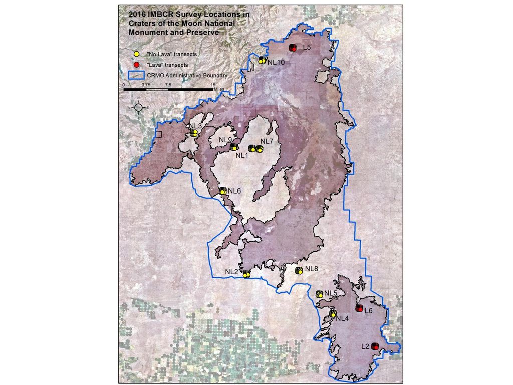
2016 IMBCR in Idaho BLM (70): USFS (97): Craters of the Moon (13)
2 Districts/6 Field Offices in SW Idaho as a pilot effort (57) USFS (97): Region 1 (81) – Clearwater (22), Idaho Panhandle (33), Nez Perce (22), Bitterroot (2), and Kootenai (2) Region 4 (16) – 4 each on Boise, Payette, Sawtooth, and Salmon-Challis
 USFS (97): Region 1 (81) – Clearwater (22), Idaho Panhandle (33), Nez Perce (22), Bitterroot (2), and Kootenai (2) Region 4 (16) – 4 each on Boise, Payette, Sawtooth, and Salmon-Challis.")
15
2017 IMBCR in Idaho (expected)
BLM ( ): 10 transects each on 14 Field Offices plus an extra 13 on Cottonwood USFS ( ): Region 1 (81) – Clearwater (22), Idaho Panhandle (33), Nez Perce (22), Bitterroot (2), and Kootenai (2) Region 4 (45) – 10 each on Boise, Payette, & Sawtooth; 15 on Salmon-Challis
: 10 transects each on 14 Field Offices plus an extra 13 on Cottonwood. USFS ( ): Region 1 (81) – Clearwater (22), Idaho Panhandle (33), Nez Perce (22), Bitterroot (2), and Kootenai (2) Region 4 (45) – 10 each on Boise, Payette, & Sawtooth; 15 on Salmon-Challis.")
16
Inform Conservation Design: Informing staff of IMBCR & uses
Rocky Mountain Avian Data Center Specialized queries available User’s guide exists Recorded demonstrations available User’s guide to IMBCR program and products for USFS In review

18
Sampling Points within Sampling Unit
Sample unit = 1 km2 • 16 points per cell • 250 m spacing Survey points • Fixed radius = 125 m • Survey area per point 4.9 ha Six minute point-counts • Three 2-minute intervals Sampling technique depends on the species of interest and the question being asked. Landbirds: 16 sampling points are evenly distributed within the cell (250 m apart). Flams Sage Grouse Other taxa: bats, elk, insects It is a monitoring design and does not have to be specific to birds. Rule sets for eliminating transects based on safety concerns, mixed ownership, private lands access permissions Point count layout for songbirds; sampling technique will vary with taxa, methods
. Flams. Sage Grouse. Other taxa: bats, elk, insects. It is a monitoring design and does not have to be specific to birds. Rule sets for eliminating transects based on safety concerns, mixed ownership, private lands access permissions. Point count layout for songbirds; sampling technique will vary with taxa, methods.")
19
Point Count Methods Visit 1 grid cell per day
Attempt to survey all 16 points Ocular vegetation data collection 6 minute point count 1 minute intervals Measure distances to each bird detected

20
Comparing trends from original and new designs
Goal is that new trend may be more precise and number may be different, but rates of change between programs can be compared. Interrupted time series Point 1 – can still use the old data Post stratification of new design to compare to old design – so you are not wasting old work Point 2 – new line s likely better Ex: Warbling vireo in aspen Redline – large contiguous stands Yellow line – any point that fell in that type – better represents aspen

21
Benefits of this approach
Increases collaboration Decreases costs of monitoring (more partners) Ability to compare bird trend to habitat trend Compare local trend to broader scale trend Increases Precision we can combine data across programs/efforts Decrease time to detect trend
 Ability to compare bird trend to habitat trend. Compare local trend to broader scale trend. Increases Precision. we can combine data across programs/efforts. Decrease time to detect trend.")
22
Benefits of IMBCR … Increase the credibility of monitoring programs with a robust sampling design and the scientific method Engage resource managers to ensure relevance Multi-scale results & tool development to support project planning and unit assessments All-lands monitoring, with the ability to generate wildlife estimates specific to management units Provide confidence to policymakers, funders and the public by increasing accountability and leveraging resources among partners Go beyond monitoring and meeting requirements to data application, informed management, feedback loops, metrics of success and impacts of restoration and habitat work. X % of USFS priority species are monitoring through IMBCR and other special projects including citizen science?

23
Partnerships = Leverage $
Colorado Partnership USFS = $80,000 + in kind CDOW = $120,000 + in kind CO- BLM= $34,000 RMBO = $15,000 (in kind) NPS = Not yet incorporated ~$74,000 Total = $249,000 May increase if NPS integrates Wyoming Partnership USFS = $50,000 + in kind WYFG = $50,000 WY-BLM = $45,000 WYNDD = $15,000 (in kind) RMBO = $7,500 (in kind) USGS = possible participation in 2008 Total = 167,500+ USGS + salary time in kind(*)
 NPS = Not yet incorporated. ~$74,000. Total = $249,000. May increase if NPS integrates. Wyoming Partnership. USFS = $50,000 + in kind. WYFG = $50,000. WY-BLM = $45,000. WYNDD = $15,000 (in kind) RMBO = $7,500 (in kind) USGS = possible participation in Total = 167,500+ USGS + salary time in kind(*)")
Similar presentations


 Data Management Kerry Shakarjian University of Denver Department of Geography Masters.>")


