Download presentation
Presentation is loading. Please wait.

1
Copernicus's contribution to land cover mapping in Africa Andreas Brink Senior Scientist Joint Research Centre – European Commission AfriGEOSS 27-29 April 2016, Victoria Falls

2
2014 Sentinel 1 – SAR imaging All weather, day/night applications, interferometry 2015 Sentinel 2 – Multispectral imaging Land applications: urban, forest, agriculture,.. Continuity of LANDSAT, SPOT, … 2016 Sentinel 3 – Ocean and global land monitoring : ocean color, vegetation, sea/land surface temperature, altimetry 2017 Sentinel 4 – Geostationary atmospheric Atmospheric composition monitoring, trans- boundary pollution 2014, 2019+ Sentinel 5 – Low-orbit atmospheric Atmospheric composition monitoring (S5 Precursor launch in 2014)
.")
3
Land Marine Atmosphere Emergency Climate Change Security Services monitoring Earth systems COPERNICUS Core Services Global

4
COPERNICUS: a public good. free and open access free and open access (Security restrictions may apply) (Security restrictions may apply) Value added of an Operational Core Services Long term and reliable provision of products and services for downstream applicationsLong term and reliable provision of products and services for downstream applications Delivery of fully validated products and servicesDelivery of fully validated products and services Data Policy
 (Security restrictions may apply) Value added of an Operational Core Services Long term and reliable provision of products and services for downstream applicationsLong term and reliable provision of products and services for downstream applications Delivery of fully validated products and servicesDelivery of fully validated products and services Data Policy.")
5
Land Service - Global Biophysical Variables

6
Objective: Support to specific EU policies at international level and support to EU commitments under international treaties and conventions Support to GMES-Africa Support to BIOPAMA 2 General public Operational Provision - Production line Evolution line Biophysical Variable in Near Real Time (NRT) Land Service - Global Sentinel 2 graphic courtesy USGS
 Land Service - Global Sentinel 2 graphic courtesy USGS")
7
June 2014 7 S3 From 2016 More products Hot Spot Monitoring In-situ data Evolution + + METOP S1 S2 Moderate resolution land cover Greenness evolution Phenology Active fires Evapotranspiration Surface soil moisture Snow area extent Snow water equivalent Lake ice coverage Lake surface water temperatures Coastal evolution Water level (lakes and rivers) Lake surface reflectance Lake turbidity
 Lake surface reflectance Lake turbidity")
8
1km resolution 333m resolution Proba-V & Sentinel 3 yearly 100m global land cover map

9
Copernicus High resolution Hot Spot Monitoring 8-10M Euro over 4 years 8-10M Euro over 4 years Initial focus on PA’s in Africa Initial focus on PA’s in Africa Beyond PA’s: TFCA, KLA, Beyond PA’s: TFCA, KLA, ~ 500,000 km2 ~ 500,000 km2

10
Implementation of a Hot Spot monitoring component Objective : To support development projects and specific monitoringObjective : To support development projects and specific monitoring Portfolio : i.e. Land cover and land use mapping … HR - VHRPortfolio : i.e. Land cover and land use mapping … HR - VHR Sector : Biodiversity conservation (protected areas and national parks), Rural development (land administration – land degradation), Infrastructure (road network – impact assessment) …Sector : Biodiversity conservation (protected areas and national parks), Rural development (land administration – land degradation), Infrastructure (road network – impact assessment) … Implementation on request from EU institutionsImplementation on request from EU institutions Pictures BIOPAMA / DG DEVCO – DG JRC
, Rural development (land administration – land degradation), Infrastructure (road network – impact assessment) …Sector : Biodiversity conservation (protected areas and national parks), Rural development (land administration – land degradation), Infrastructure (road network – impact assessment) … Implementation on request from EU institutionsImplementation on request from EU institutions Pictures BIOPAMA / DG DEVCO – DG JRC.")
11
11 Implementation of a Hot Spot monitoring component Cataloguing, archiving of all generated products, and products dissemination process. Independent validation and quality control of all generated products. Pictures BIOPAMA / DG DEVCO – DG JRC

12
Class1990 km 2 2000 km 2 2010 km 2 1990- 2000% 2000- 2010% Tree Cover1,670.901,565.201,530.00-6.3-2.2 Tree Cover Mosaic1,256.101,069.601,018.40-14.8-4.8 Other Wooded Land 1,537.701,069.60951.1-30.4-11.1 Agriculture689.91,545.501,825.3012418.1 Water16.415.815.4-3.7-2.8 Other Land690685.7591.9-0.6-13.7 Clouds and shadows 110.817.429-84.366.7 Urban33.737.438.5113 - Method and Tools Development - Data and Results Distribution - Training and Capacity Building

13
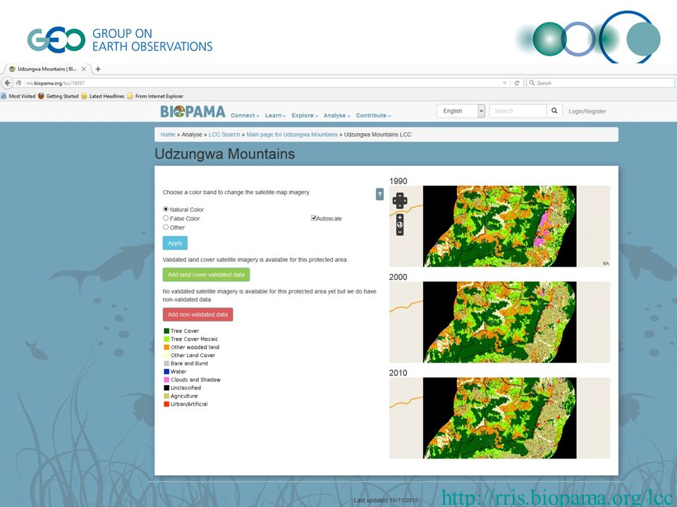
http://rris.biopama.org/lcc
14
SPOT VGT 1km MODIS 250m PROBA-V 1km – 333m GLOBAL-V Sentinel 3 300m Landsat series 30m Sentinel 2 10 – 20m Resolution – up and downscaling – compatibility with planned GL yearly global land cover product Product cube High resolution Hot Spot Monitoring

15
15 Thank you!

Similar presentations

 A demonstration space mission dedicated to land surface environment (Vegetation and Environment New.>")


 Coordination Group.>")
, Australia (CSIRO), Norway (NSC), Japan (JAXA), Canada (CSA), Brazil (INPE), USA (USGS), Thailand (GISTDA)>")

, USA. 13-14 September 2012 European Space Agency Frank Martin Seifert Earth Observation Programme ESRIN,>")


, Terra, and the MODIS Instrument Michele Thornton 406-243-6263.>")


